Showing 1090 items matching "geological"
-
 Ringwood and District Historical Society
Photographs, 1979-80 MMBW pipe line project at Hubbard Reserve, North Ringwood � Track down to creek bridge
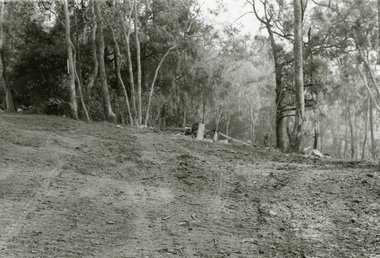
Part of a 43-photo record of the MMBW�s engineering feat in drilling a 12 inch pipe line up to 40 feet deep through rock hardened by volcanic action associated with geological fault that occurs along the line. The work took place from October 1979 to May 1980 on the southern boundary of Hubbard Reserve, North Ringwood. The collection was presented to the Ringwood Historical Research Group by J Clarke on 9th June 1980.E565 N12 13 May 1980 A43 My old track down to the bridge over the creek. The pipe line went to the right of the big tree 40-foot down. -
 Ringwood and District Historical Society
Photographs, 1979-80 MMBW pipe line project at Hubbard Reserve, North Ringwood � The new trach goes on down to Debbie Place
Part of a 43-photo record of the MMBW�s engineering feat in drilling a 12 inch pipe line up to 40 feet deep through rock hardened by volcanic action associated with geological fault that occurs along the line. The work took place from October 1979 to May 1980 on the southern boundary of Hubbard Reserve, North Ringwood. The collection was presented to the Ringwood Historical Research Group by J Clarke on 9th June 1980.E566 N13 13 May 1980 A43 The parting of the ways. My old track goes left to Burlock Avenue. The new way goes on down to Debbie Place. -
 Ringwood and District Historical Society
Photographs, 1979-80 MMBW pipe line project at Hubbard Reserve, North Ringwood � Manhole behind 29 Burlock Avenue
Part of a 43-photo record of the MMBW�s engineering feat in drilling a 12 inch pipe line up to 40 feet deep through rock hardened by volcanic action associated with geological fault that occurs along the line. The work took place from October 1979 to May 1980 on the southern boundary of Hubbard Reserve, North Ringwood. The collection was presented to the Ringwood Historical Research Group by J Clarke on 9th June 1980.E566 N5 13 May 1980 A43 Manhole behind 29 Burlock Avenue, 38 feet deep. Debbie place is on the far right. -
 Ringwood and District Historical Society
Photographs, 1979-80 MMBW pipe line project at Hubbard Reserve, North Ringwood � The manhole in the creek
Part of a 43-photo record of the MMBW�s engineering feat in drilling a 12 inch pipe line up to 40 feet deep through rock hardened by volcanic action associated with geological fault that occurs along the line. The work took place from October 1979 to May 1980 on the southern boundary of Hubbard Reserve, North Ringwood. The collection was presented to the Ringwood Historical Research Group by J Clarke on 9th June 1980.E563 1 April 1980 A43 The manhole in the creek, waiting until boring is finished. -
 Ringwood and District Historical Society
Photographs, 1979-80 MMBW pipe line project at Hubbard Reserve, North Ringwood � Tracked drill rig
Part of a 43-photo record of the MMBW�s engineering feat in drilling a 12 inch pipe line up to 40 feet deep through rock hardened by volcanic action associated with geological fault that occurs along the line. The work took place from October 1979 to May 1980 on the southern boundary of Hubbard Reserve, North Ringwood. The collection was presented to the Ringwood Historical Research Group by J Clarke on 9th June 1980.E561 N16 3 March 1980 A43 Tracked drill rig on the line of trench for sewer to Debbie Place -
 Ringwood and District Historical Society
Photographs, 1979-80 MMBW pipe line project at Hubbard Reserve, North Ringwood � Air track drill rig
Part of a 43-photo record of the MMBW�s engineering feat in drilling a 12 inch pipe line up to 40 feet deep through rock hardened by volcanic action associated with geological fault that occurs along the line. The work took place from October 1979 to May 1980 on the southern boundary of Hubbard Reserve, North Ringwood. The collection was presented to the Ringwood Historical Research Group by J Clarke on 9th June 1980.E561 N19 3 March 1980 A43 Air track drill rig in position as in N18 -
 Ringwood and District Historical Society
Photographs, 1979-80 MMBW pipe line project at Hubbard Reserve, North Ringwood � Last days of the boring
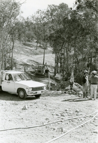
Part of a 43-photo record of the MMBW�s engineering feat in drilling a 12 inch pipe line up to 40 feet deep through rock hardened by volcanic action associated with geological fault that occurs along the line. The work took place from October 1979 to May 1980 on the southern boundary of Hubbard Reserve, North Ringwood. The collection was presented to the Ringwood Historical Research Group by J Clarke on 9th June 1980.E561 N1 1 April 1980 A43 Last days of the boring. The mole had broken between the last two shafts. Dominic Di Nezza and Glen Pearson discuss further moves to release it. -
 Ringwood and District Historical Society
Photographs, 1979-80 MMBW pipe line project at Hubbard Reserve, North Ringwood � Drill rig
Part of a 43-photo record of the MMBW�s engineering feat in drilling a 12 inch pipe line up to 40 feet deep through rock hardened by volcanic action associated with geological fault that occurs along the line. The work took place from October 1979 to May 1980 on the southern boundary of Hubbard Reserve, North Ringwood. The collection was presented to the Ringwood Historical Research Group by J Clarke on 9th June 1980.E561 N17 3 March 1980 A43 Powder-monkey marks out the spots for holes -
 Ringwood and District Historical Society
Photographs, 1979-80 MMBW pipe line project at Hubbard Reserve, North Ringwood � View towards Debbie Place
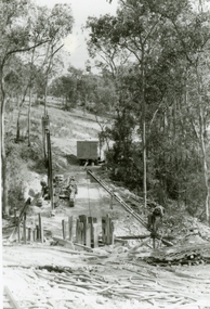
Part of a 43-photo record of the MMBW�s engineering feat in drilling a 12 inch pipe line up to 40 feet deep through rock hardened by volcanic action associated with geological fault that occurs along the line. The work took place from October 1979 to May 1980 on the southern boundary of Hubbard Reserve, North Ringwood. The collection was presented to the Ringwood Historical Research Group by J Clarke on 9th June 1980.E561 N15 3 March 1980 A43 View towards Debbie Place, showing 2 swivel cranes at shafts, timber of manhole in creek, the tracked drill rig and its compressor caravan. -
 Ringwood and District Historical Society
Photographs, 1979-80 MMBW pipe line project at Hubbard Reserve, North Ringwood � Boring mole pit
Part of a 43-photo record of the MMBW�s engineering feat in drilling a 12 inch pipe line up to 40 feet deep through rock hardened by volcanic action associated with geological fault that occurs along the line. The work took place from October 1979 to May 1980 on the southern boundary of Hubbard Reserve, North Ringwood. The collection was presented to the Ringwood Historical Research Group by J Clarke on 9th June 1980.E561 N14 3 March 1980 A43 View west behind No. 29 Burlock Avenue, showing gantry over manhole 38 feet deep. -
 Ringwood and District Historical Society
Photographs, 1979-80 MMBW pipe line project at Hubbard Reserve, North Ringwood � The work on sewer line from 29-39 Burlock Avenue
Part of a 43-photo record of the MMBW�s engineering feat in drilling a 12 inch pipe line up to 40 feet deep through rock hardened by volcanic action associated with geological fault that occurs along the line. The work took place from October 1979 to May 1980 on the southern boundary of Hubbard Reserve, North Ringwood. The collection was presented to the Ringwood Historical Research Group by J Clarke on 9th June 1980.E561 N11 3 March 1980 A43 The work on sewer line from 29-39 Burlock Avenue. Lundy-Clarke's place on sky-line. -
 Ringwood and District Historical Society
Photograph, 1979-80 MMBW pipe line project at Hubbard Reserve, North Ringwood. Debbie Place from the east end
Part of a 43-photo record of the MMBW's engineering feat in drilling a 12 inch pipe line up to 40 feet deep through rock hardened by volcanic action associated with geological fault that occurs along the line. The work took place from October 1979 to May 1980 on the southern boundary of Hubbard Reserve, North Ringwood. The collection was presented to the Ringwood Historical Research Group by J Clarke on 9th June 1980.E550 N12 Dec 1979 A43 Debbie Place from the east end -
 Ringwood and District Historical Society
Photographs, 1979-80 MMBW pipe line project at Hubbard Reserve, North Ringwood � View from Debbie Place, preliminary sewer work
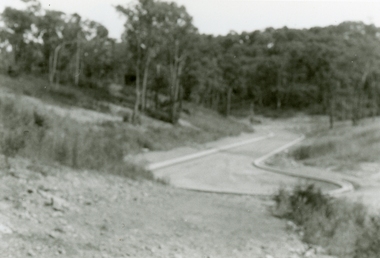
Part of a 43-photo record of the MMBW�s engineering feat in drilling a 12 inch pipe line up to 40 feet deep through rock hardened by volcanic action associated with geological fault that occurs along the line. The work took place from October 1979 to May 1980 on the southern boundary of Hubbard Reserve, North Ringwood. The collection was presented to the Ringwood Historical Research Group by J Clarke on 9th June 1980.E561 N13 28 Feb 1980 A43 View from Debbie Place, preliminary sewer work -
 Ringwood and District Historical Society
Photographs, 1979-80 MMBW pipe line project at Hubbard Reserve, North Ringwood � Line of tunnel shafts behind 29-39 Burlock Avenue
Part of a 43-photo record of the MMBW�s engineering feat in drilling a 12 inch pipe line up to 40 feet deep through rock hardened by volcanic action associated with geological fault that occurs along the line. The work took place from October 1979 to May 1980 on the southern boundary of Hubbard Reserve, North Ringwood. The collection was presented to the Ringwood Historical Research Group by J Clarke on 9th June 1980.E561 N10 Feb 1980 A43 Line of tunnel shafts behind 29-39 Burlock Avenue. Horizontal gantry was above the manhole in the corner of No. 29. -
 Ringwood and District Historical Society
Photographs, 1979-80 MMBW pipe line project at Hubbard Reserve, North Ringwood � First hole west of bore hole at 39 Burlock Avenue
Part of a 43-photo record of the MMBW�s engineering feat in drilling a 12 inch pipe line up to 40 feet deep through rock hardened by volcanic action associated with geological fault that occurs along the line. The work took place from October 1979 to May 1980 on the southern boundary of Hubbard Reserve, North Ringwood. The collection was presented to the Ringwood Historical Research Group by J Clarke on 9th June 1980.E561 N9 Feb 1980 A43 First hole west of bore hole at 39 Burlock Avenue -
 Bendigo Historical Society Inc.
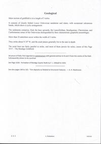
Document - MINING REPORTS - GEOLOGICAL REPORT OF MAIN SECTION OF GOLDFIELD
Handwritten notes by Albert Richardson, with typed copy, on a Geological report of main section in a length of 5 miles. Report mentions sandstones and slates, with occasional calcareous bands, which show a cyclic arrangement. Also mentioned are different zones of sediments, anticlines, structure of the field and references: Page 1028 Formation of Bendigo Quartz Reefs by F R Stilwell to 1032 and pages 160 to 163 'Ore deposits as Related to Structural Features - A H Newhouse. document, gold, mining reports, mining reports, geological report of main section of goldfield, the bendigo goldfields page 1015, formation of bendigo quartz reefs by f r stilwell page 1028 to 1032, ore deposits as related to structural features pages 160 to 163 a h newhouse -
 Bendigo Historical Society Inc.
Document - VICTORIA HILL - QUESTION 5 ON VICTORIA HILL
Handwritten notes and carbon copy titled Question 5. Notes refer to Victoria Hill being opened up by Theodore Ballerstedt and his son early in 1854. Theodore Ballerstedt left for Germany having sold his home, crushing battery and mine to Mr. Geo Lansell. He called the mine the '180'. Next mine north to the '180' was the Victoria Quartz. Also contains notes on machinery, geological formations and earning from the mines.document, gold, victoria hill, victoria hill, question 5 on victoria hill, theodore ballerstedt, mr geo lansell, fortuna villa, commonwealth survey regiment, the 180, ballerstedt's original open cut, bendigo south rotary club, john wybrandt, north old chum coy, victoria quartz, victoria reef quartz company, mr william rae, a roberts & sons united ironworks, australian mining standard special edition 1899, bendigo advertiser 10/2/1897, a harkness & coy, bendigo advertiser 30/6/1910 page 5, rae's open cut, e j dunn, bendigo saddle reefs, wittscheibe's 'jeweller's shop', roberts & frost, ashley noy & coy, grant & co, woodward & son, couth allen and co, taylor gould and co, crawshaw & co, roberts & co -
 Bendigo Historical Society Inc.
Map - GEOLOGICAL MAP: BENDIGO GOLD FIELDS
GEOLOGICAL MAP - BENDIGO GOLD FIELDS - Donated by JOHN HORWOOD. Two geological maps of the Bendigo Gold fields. The maps display , reef lines, Hills, Dams and mine locations. Also Anticlines, sinclines, shafts, alluvial deposits, contours and gullys. All items are superimposed on a map of the major roads and streets of Bendigo. The maps were printed by The Victorian Minister for Mines in 1923 and re-issued in 1936. The maps have been specifically framed and donated to The Bendigo Historical Society Inc. in May 2015 for display at Specimen Cottage. John had been a student at The School of Mines- Bendigo and found them useful as a student living in Bendigo. Prior to being framed , the maps have been kept rolled up in his home. Accession Number 309/15 Were on Display at Specimen Cottage 2015 - 2020. After all items removed from SC to the BRAC in 2021 the framed maps could not be located. Search ongoing. BP 2.3.2023Victorian Minister of Minesgoldfields -
 Federation University Historical Collection
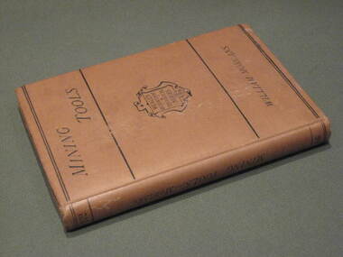
Book, Manual of Mining Tools, 1871, 1871
The author, William Morgans, was a lecturer on mining at the Bristol School of Mines. The owner of the book, William Baragwanath, was a former student of the Ballarat School of Mines who held the following positions: Department of Mines (1897-1922); director of the geological survey (1922-24); chief mining surveyor (1924-32); secretary for mines (1932-34); chief mining surveyor (1934-43); consultant to the Department of Mines (1943-50); President, Royal Society of Victoria (1943-44), councillor of the Ballarat School of Mines (1916-50).Hard cover book of 207 pages with buff cloth cover. The books covers materials andf processes used in the manufacture of tools, special uses, qualities and efficiciency. It includes 235 wood engravings of mining tools drawn to scale. Tools include borers, hammers, sledges, picks, shovels, spades, saws, helves and handles.Title page handwritten in ink 'W.B.' [William Baragwanath]mining, tools, ballarat school of mines, geology, bristol school of mines, government geologist, william baragwanath -
 Federation University Historical Collection
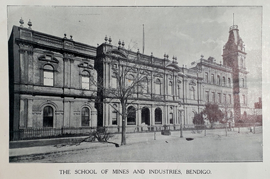
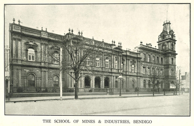
Booklet - Booklet - Prospectus, Cambridge & Leaney Printers, Bendigo Junior Technical School, School of Mines, Prospectus 1913, 1913
The Bendigo School of Mines was opened in 1873 to meet the scientific and technical needs of the mining industry on the local gold fields. Mining, chemistry, geology, metallurgy and art were taught. In c.1907 a Junior Technical School commenced to operate at the School of Mines and Industry. This was to enable boys who had completed primary school the opportunity to continue their education and learn skills to assist them in their future. In c.1961 the Junior Technical School ceased to operate with that function being transferred to the White Hills and Kangaroo Flat technical schools.Red/brown soft covered booklet.A.W Steane written on front coverbendigo junior technical school, prospectus, w.h walter, j.r.v anderson, a.w. steane, w.s. lake, k.c. abbott, mr grant, mathematics and science, woodwork and sheet metal, art, principal, bendigo -
 Federation University Historical Collection
Booklet, Cambridge Press Bendigo, Bendigo Junior Technical School Prospectus, 1914, 1914
The Bendigo School of Mines was opened in 1873 to meet the scientific and technical needs of the mining industry on the local gold fields. Mining, chemistry, geology, metallurgy and art were taught. In c.1907 a Junior Technical School commenced to operate at the School of Mines and Industry. This was to enable boys who had completed primary school the opportunity to continue their education and learn skills to assist them in their future. In c.1961 the Junior Technical School ceased to operate with that function being transferred to the White Hills and Kangaroo Flat technical schools.Grey soft covered booklet with green printing. The prospectus outlines preparatory courses in Trade, Art and Science. Photographs include Physical Culture, Geometrical Development, Science Laboratory, Design, Sheetmetal, Woodwork and Modelling.Handwritten on front Cover A.W. Steanebendigo junior technical school, prospectus, head master, a e tutton, mathematics and science master, j a donald, woodwork and sheet matal, h f day, crafts master, k c abbott -
 Nillumbik Shire Council
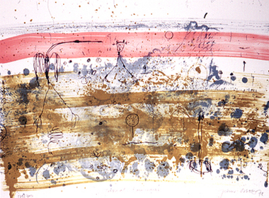
Print (Lithograph): John Olsen (b.1928 NSW), John Olsen, Tropical Rain Shower from The Bodford Terrace Suite, 1978
A typical Olsen painting combines an implied aerial view with an ambiguous and seemingly unpremeditated figuration. His characteristically quizzical line and irregular squiggles and dots deftly render countless organisms, large and minute. Their environment is conjured through loosely brushed and stained expanses of colour (on canvas or hardboard) and lines which sometimes read as geological mappings. In Olsen's work there is no foreground/ middle ground/ background, nor any sign of European landscape's concern with "human scale." Instead he employs simultaneously the contrary vantages of naturalist and geographer. 'Tropical Rain Shower' by John Olsen forms one of the eight artworks represented in the Bodford Terrace Suite. Eight of Australia's finest artists were brought together to create a folio of lithographic prints to celebrate the restoration of historic Bodford Terrace. Printed at the Druckma Press by John Robinson under the supervision of master printer Jock Abbott. The folio edition was limited to 300 signed and numbered folios. The lithographs were printed on special heavy weight french Arche's paper in accordance with the tradition of this artistic medium. Lithographic print on paper.Signed John Olsen '78, lower right hand corner. Edition 179/300bodfford terrace collection, john olsen, tropical rain shower -
 Federation University Historical Collection
Book, Cassell, Petter, Galpin & Co, Popular Educator Vol. 5
Green/black clothcovered book of 412 pages. Includes illustrations and topics such as Knights Templar, Red Cross Knights, Lesson in Architecture, botany, arithmetic, algebra, static forces, Cambridge University, chemistry, latin, Euclid, fossils, geology, Greek, Electricity, German, Organic Chemistry, shells, pearls, North America, nightshades, the Thirty Years War, commerce, reflection of light, book-keeping, mosses, South America, hydrostatics, camera obscura, London UniversityStamped 'Springs Public Libray'cambridge university, knights templar, red cross knights, organic chemistry, north america, thirty years war, south america, camera obscura, london university, springs public library -
Federation University Historical Collection
Document, Pat Hope (Dean of Business and Information Management), Ballarat University College Prizes and Scholarships, 1991, 26/02/1991
A prize is a reward granted in recognition of excellence, such as cash, an article as a book or a medal, or both. A scholarship is a grant for the maintenance of a student. 12 page typed document relating to prizes and scholarships offered at Ballarat University College, and their conditions for award. Prizes in 1990 included the following: Chemistry, Josephine Brelaz (Physics, Metallurgy, Multi-disciplinary Science, Electrical Engineering, Civil Engineering), Harold Yates (Geology), Martha Pinkerton (Art), Adrienne Guy Award (Art), Librarianship, Business, Mica Smith (Mining Engineering), Mary Allnutt Award (Humanities and Social Sciences), R.W. Richards Medal.ballarat university college, prizes, awards, scholarships, r.w. richards medal, josephine brelaz award,, martha pinkerton award, adrienne guy award, mica-smith award, mary allnutt award, martha pinkerton, scholarships -
 Bendigo Historical Society Inc.
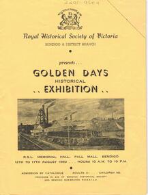
Document - LYDIA CHANCELLOR COLLECTION: ROYAL HISTORICAL SOCIETY OF VICTORIA
A yellow catalogue published by the Royal Historical Society of Victoria Bendigo & District Branch. It is presenting the ' Golden Days Historical Exhibition ' at the R.S.L. Memorial Hall, Pall Mall, Bendigo 12th to 17th August 1960. The categories of exhibits are antiques, bush ranging, coins and tokens, documents, fashions, firearms, geology, gold mining, pioneers, postal history, prints and photography, shipping and sport. Within the catalogue are Bendigo Advertiser July and August cuttings relating to the exhibition.history, australian, exhibition, lydia chancellor collection, collection, bendigo, australia, royal historical society of victoria, exhibits, bendigo city council -
 Bendigo Historical Society Inc.
Document - VICTORIA HILL - NOTES ON VICTORIA HILL
Handwritten notes and typed copy, on Victoria Hill. Notes mention the completion of the Bendigo and District Tourist Association's Mining project, what can be seen in the area, the views of Bendigo from the top of the 68 feet high poppet legs, geological features and rock colourings in the open cuts, its direct link to Fortuna mansion and the one-time deepest mine workings in the world. On the back is a number of references and page numbers. Notes prepared by Albert Richardson.document, memo, victoria hill, victoria hill, notes on victoria hill, bendigo and district tourist association, new chum line, lansell's fortuna mansion, central nell gwynne -
 Bendigo Historical Society Inc.
Map - HUSTLER'S REEF MINE - EAST & WEST CROSS-CUTS, NORTH & SOUTH OF SHAFT
East & West Crosscuts, North & South of Shaft, Hustler's Reef Mine Bulletin No 33, Plate No XIX. Map shows main shaft and smaller drawing of section with different stone encountered. Also gives location in relation to the shaft, e. g. 225'E & 150'S of Shaft. Reference diagram to show the different stone and features encountered. Geological Survey of Victoria emblem. Signed by H A Whitelaw, Underground Survey Office Bendigo, September 1913. mining, parish map, hustler's reef mine, east & west cross-cuts north & south of shaft, geological survey of victoria, h a whitelaw, underground survey office bendigo -
 Federation University Historical Collection
Article - Article - Women, Ballarat School of Mines: Women of Note; Jeanette Perkins, First Female Geology Student, (1927 - )
Jeanette Perkins was born in 1927 at Ballarat. She attended Alfredton State School and Pleasant Street State School before completing her secondary schooling at Ballarat High School (BHS). During her later years at BHS Perkins decided that she wanted to become a geologist, but was ineligible for university when she failed Leaving Certificate maths. She attended an interview with the principal (Heseltine) at the Ballarat School of Mines (SMB) and announced that she wanted to be a geologist. Heseltine was, according to Perkins, aghast: he informed her that there had never been a female geologist at SMB and they didn't want one. But Perkins persisted. Only then did Heseltine reluctantly enrol her in the School's Applied Chemistry Course which offered the most geological subjects, moreover, it was the only one he considered available to a 'mere' female. After graduating Perkins was employed as a metallurgical chemist with M.B. Johns Valves, Ballarat. In 1949 she married Alfred Watson. In 1951 Jeanette and Alf Watson moved to Melbourne where she commenced work as a metallurgical chemist at the Maribyrnong Ordnance Factory while studying geology part time: Alf returned to study at the University of Melbourne. Once again, Watson set a precedent by becoming the first female student to study geology part-time at the Melbourne Technical College. Increasing demands brought about by her growing family, she turned to part-time lecturing second and third year stratigraphy and palaeontology at RMIT. In 1957 the Watsons moved to the Mary Kathleen Uranium Mine in NW Queensland where he was appointed electrical design engineer. After their return to Melbourne in 1960, Jeanette taught herself to SCUBA dive and quickly developed a passion for the sport and the marine environment. She taught senior science to secondary students for 10 years whilst working towards a Masters degree. In 1991 Jeanette Watson was awarded a Doctorate from Deakin University.women of note, ballarat school of mines, alfredton state school, pleasant street state school, ballarat high school, leaving certificate maths, interview with principal, heseltine, geologist, applied chemistry course, no female geologists, metallurgical chemist, married 1949, melbourne, ordinance factory, part time study, melbourne technical college, rmit, part time lecturer, scuba diving, science teacher for ten years, masters degree, doctorate, deakin university -
 Federation University Historical Collection
Photograph - Colour, Ballarat College of Advanced Education Staffmembers, c1986, c1986
Ballarat College of Advanced Education is a predecessor institution of Federation University Australia. The staffmembers depicted were 'new staff' as outlined in 'CAENews'.Seven portraits of Administrative Staff Members of Ballarat College of Advanced Education. .1) Leanne Barltett, Secretary to Academic Secretary, 1986 .2) Sue E. Taylor, Secretary, Geology/Metallurgy, 1986 .3) Janine Balharrie. Acquisitions Librarian, 1986 .4) Maureen Addenbrooke, Community Officer, Registry, 1987 .5) Maureen Lynch, typist/receptionist, Arts, 1987 .6) Cecily Moreton, Counsellor, 1987 .7) Heather Martin, Laboratory Assistant, Applied Biology/Chemistry, 1987ballarat college of advanced education, bartlett, taylor, balharrie, addenbrooke, lynch, moreton, martin, janine balharrie, librarian -
 Bendigo Historical Society Inc.
Map - HUSTLER'S REEF MINE - TRANSVERSE SECTION OF THE HUSTLER'S REEF MINE
Transverse Section of the Hustler's Reef Mine on the Hustler's Line of Reefs. Bulletin No 33, Plate No XVIII. Shows cross-cuts and their depth, different types of stone and geological features encountered. Drawing of poppet legs at the surface and Sill of Shaft 756.39 ft above Sea Level. Reference Table shows key to the different stone and geographical features encountered. Geographical Survey of Victoria. Signed by H A Whitelaw, Underground Survey Office, Bendigo, September 1913. Thompson's Reef is also mentioned on the map. mining, hustler's reef mine, transverse section of the hustler's reef mine, geological survey of victoria, h a whitelaw, underground survey office bendigo, thompson's reef.