Showing 1748 items
matching grove
-
 Whitehorse Historical Society Inc.
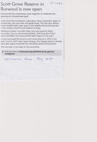
Article, Scott Grove Reserve, Aug 2023
A new open space park has been established at 14 - 16 Scott Grove, Burwoodnon-fictionA new open space park has been established at 14 - 16 Scott Grove, Burwoodscott grove reserve, scott grove burwood no 14 -16, playgrounds -
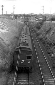 Darebin Art Collection
Photograph, David Wadelton, A view from the Westbourne Grove rail bridge, 1976
trainline, westbourne grove, northcote -
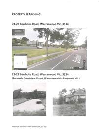 Ringwood and District Historical Society
Archive - Parent Record, Family History - Collection of 1960s Land Titles and Property Records associated with Carter and Brown Families and others, Grandview Grove, (later Bemboka Road) Warranwood, (Parts of Crown Grant 20, 1854)
Set of four clear-fronted plastic A4 binders containing family history research printouts and photocopies. -
 Old Colonists' Association of Ballarat Inc.
Photograph, Clare Gervasoni, 5 Charles Anderson Grove, Lake Gardens
charles anderson grove, old colonists association of ballarat, retirement village, 5 charles anderson grove -
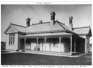 Linton and District Historical Society Inc
Photocopy, Pine Grove : home of O'Beirne family
Home of O'Beirne family, in Skipton Road, Linton. Built in 1907.A4 photocopy of photograph showing a large wooden house with decorative lacework around the verandah, four chimney,s iron roof with decorative ridge cap. pine grove, fw & ae o'beirne, o'beirne residence linton -
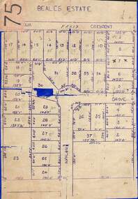 Ringwood and District Historical Society
Map, Subdivision Plan of 37 residential allotments on Panorama Avenue, Felix Crescent, Evelyn Road and Avalon Grove, Ringwood, Victoria - (Undated - circa 1960)
Stencilled copy of map on blue cardboard backingBeales Estate -
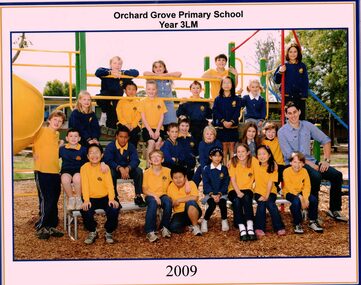 Whitehorse Historical Society Inc.
Photograph - Coloured School Photograph, Orchard Grove Primary School 2009, 2009
primary school, south blackburn, orchard grove -
 Kew Historical Society Inc
Collection, Floods in North Kew (Series), 1929–1934
Flooding of the Yarra Valley, including that section of the Yarra bordering Kew and Kew East in the north and west of the municipality, was a regular occurrence. Extreme flood events of the Yarra River are recorded to have occurred in 1891, 1901, 1916, 1923 and 1934. The Municipality of Kew's response to these floods was to enact planning decisions restricting residential development in flood prone areas following the floods of 1916, 1921 and 1934. While floods continued after the development of the Upper Yarra Reservoir (construction 1948-57), the regularity and extent of these inundations diminished. Natural disasters had an impact on the development and settlement of Melbourne and its suburbs. Flooding in the Melbourne region was a regular event in the nineteenth and for most of the twentieth centuries. Changes in the impact of natural disasters could occur due to a number of factors. This collection of small snapshots, mostly taken from Kellett Grove in North Kew, provide provenanced evidence of flooding in the area before the development of the unnatural flood barrier that is the Eastern Freeway.Collection of 16 monochrome photographs, annotated on verso by different hands, of the flooding of the River Yarra in North Kew in the third and fourth decades of the twentieth century [1920s & 1930s]. Individual photos include the dates of different floods. Many of the photos were taken from the rear of 8 Kellett Grove; a house still extant in 2023yarra river -- north kew, floods -- yarra valley, floods -- north kew, floods -- 1929, floods -- 1934, natural disasters -- kew -
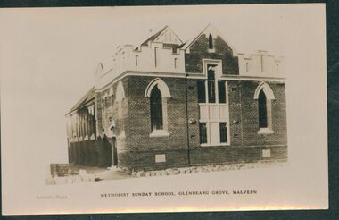 Uniting Church Archives - Synod of Victoria
Photograph, undated
The opening services of the Glendearg Grove Methodist Church South Malvern were held on 5th February 1905. The church had seating for 400 people and was built at a cost of 1200 pounds. The President of Conference the Rev. W.H. Fitchett D.D. preached at the opening services.Sepia photograph showing the the Glendearg Grove Methodist Sunday School. glendearg grove malvern, methodist, sunday school -
Glen Eira Historical Society
Document - Athole, Poplar Grove, 18, Carnegie
3 page photocopy of an article on Athole, Poplar Grove, 18, Carnegie, from the Caulfield Conservation Study by Andrew Ward in 01/1995. Article includes a description, brief history, state of significance of Athole, poor quality photography and a bibliography.carnegie, poplar grove, athole, kelleher john thomas, rosstown swamp, market gardens, mackay richard, fish kareen, strathnaver estate, land subdivision, architects, brick houses, stables, greenhouses, architectural styles, architectural features -
Glen Eira Historical Society
Article - Mayfield Grove, 2/2A, Caulfield North
Newspaper advertisement, source unknown, dated 30-/09/2011, giving details concerning the forthcoming auction of 2/2A Mayfield Grove, Caulfield North. Includes one colour photographs of the house exterior and three colour photographs of the house interior.jones noel, mayfield grove, caulfield north, caulfield park, estate agents -
Glen Eira Historical Society
Article - Carrington Grove, 8, St Kilda East
A one page typed report dated 05/08/1989, by H Bullock and R Landells, containing a brief history of the house at 8 Carrington Grove from 1914 to 1989. The report provides a list of occupants and briefly mentions Charles Carrington and Lord Loch after whom Loch Avenue and Carrington Grove was named. The file also includes one page of accompanying handwritten working notes. The file also includes a photocopy of an article from a book, title and publication details unknown, containing a biography of Charles Robert Carrington. A one page research note by Chloe Stapleton, dated 08/05/2012, identifies the source of the article.carrington grove, st kilda east, loch avenue, heads of state, governors, officials, depression 1890s, economic depression, world war 1914-1918, carrington charles robert, harrop thomas s, harrop r, koesis l, mitchell n i, bullock h, landells r -
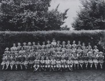 Coburg Historical Society
Black and white photograph of the students of Clare Grammar School, c1948 - 1954
The students of Clare Grammar School, The Grove, Coburg, c1948 - 1954. Names include: 3rd row down - 4th from left - Teddy Lithgow; 7th from left - Peter Weddle. 4th row down - 7th from left - Lorna Patchett.Black and white photographclare grammar school, the grove, coburg -
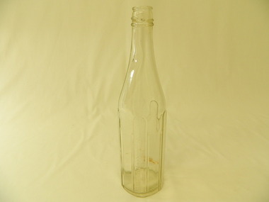 Kiewa Valley Historical Society
Bottle - Sauce, Late 1940's
Sauce came in bottles bought at the local grocery store or at a large city store on a shopping expedition. The shape and embossing on the bottle changed as did the stopper used to seal it. Bottles were re cycled remaining the property of the manufacturer. History of Groves McVitty & Co. Pty. Ltd. Melbourne.Historical: Change of bottles - shape, glass, embossing, use Aesthetic: Display showing embossing and shape.Clear glass bottle with straight sides a little over half way up. These sides have 4 panels curved at the top equally spaced vertically around the sides with 1 panel seemingly missing. The panels are embossed onto the glass and have accentuated embossed sides. 1 panel is heavily embossed with print in capital letters. It has a screw top. The base is embossed. Side: 'The Property of / Groves McVitty & Co Pty Ltd Melb.' Base: 'The / Property of / Groves McVitty / & Co Pty Ltd / Melb.'sauce, glass bottle, groves mcvitty & co. pty ltd mebourne -
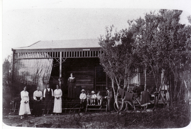 Whitehorse Historical Society Inc.
Photograph, Louis Schwerkolt Holiday Home, c1917
Black and white photograph of Holiday Home of Louis & Francesca (Cissie) Schwerkolt - Ti Tree Grove, Mentone - c1917 - 'Mitcham'. Left to right - Louisa, Cissie, Les and Frances (Dit) Hogan and four children, Alice (middle daughter on verandah). Man in hat is believed to be Van Pruyen, husband of Dora, older sister of Cissie & Dit - it may be Louis Schwerkolt.schwerkolt family, schwerkolt cottage -
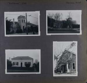 Glen Eira Historical Society
Album - Album page, Ercildoune (576), Inkerman Street, Circa 1972
This photograph is part of the Caulfield Historical Album 1972. This album was created in approximately 1972 as part of a project by the Caulfield Historical Society to assist in identifying buildings worthy of preservation. The album is related to a Survey the Caulfield Historical Society developed in collaboration with the National Trust of Australia (Victoria) and Caulfield City Council to identify historic buildings within the City of Caulfield that warranted the protection of a National Trust Classification. Principal photographer thought to be Trevor Hart, member of Caulfield Historical Society. Most photographs were taken between 1966-1972 with a small number of photographs being older and from unknown sources. All photographs are black and white except where stated, with 386 photographs over 198 pages. Vol 1 Caulfield's Building Heritage by Dr Geulah Solomon states that Ercildoune was the home of Sir Samuel Wilson and later, Arthur Knox. Knox is likely the person who subdivided the land, creating Ercildoune Street.Page 100 of Photograph Album with two photographs (landscape) of Ercildoune and two photographs (one landscape and one portrait) of two other houses on Inkerman Street.Handwritten: "Ercildoune" (576) [top left] / Inkerman Street [top right] / 138 INKERMAN ST [under bottom left photo] / LABASSA GROVE CORNER OF INKERMAN OPPOSITE ERCILDOUNE [under bottom right photo] / 100 [bottom right]trevor hart, east st kilda, ercildoune, mansions, towers, gardens, bloomsbury, inkerman road, labassa grove, attic houses, porches, inkerman street, caulfield north, st kilda east, sir samuel wilson, arthur knox, ercildoune street, house names -
 Eltham District Historical Society Inc
Photograph, Bird family Orchard, Pitt Street, Eltham, c.1980s
View looking northeast from near junction of Wattle Grove and Mount Pleasant Road across to Eucalyptus Road on right and Pitt Street at top. Early pioneer, George Bird Snr. arrived from England in 1852 and lived with his uncle, George Stebbing. He worked for him as bricklayer's assistant in building, among others, the Anglican and Methodist Churches in Eltham. In 1862 he purchased land in the east end of Pitt Street bounded by Eucalyptus Road and Wattle Grove and established a mixed farm and orchard. His son, Arthur Bird succeeded him and also worked on this orchard which then passed to Arthur's son, Harold Bird OAM, where Harold and Yvonne Bird lived in the family home till the mid 2000s A4 size photographic print reproduction of a paintingaos6, wattle grove, pitt street, arthur bird, bird family orchard, eucalyptus road, george bird, harold bird, yvonne bird, eltham -
 Eltham District Historical Society Inc
Photograph, Bird family Orchard, Pitt Street, Eltham, c.1980s, 1980s
View looking northeast from near junction of Wattle Grove and Mount Pleasant Road across to Eucalyptus Road on right and Pitt Street at top. Early pioneer, George Bird Snr. arrived from England in 1852 and lived with his uncle, George Stebbing. He worked for him as bricklayer's assistant in building, among others, the Anglican and Methodist Churches in Eltham. In 1862 he purchased land in the east end of Pitt Street bounded by Eucalyptus Road and Wattle Grove and established a mixed farm and orchard. His son, Arthur Bird succeeded him and also worked on this orchard which then passed to Arthur's son, Harold Bird OAM, where Harold and Yvonne Bird lived in the family home till the mid 2000s A4 size photographic printaos6, wattle grove, pitt street, arthur bird, bird family orchard, eucalyptus road, george bird, harold bird, yvonne bird, eltham -
 Old Colonists' Association of Ballarat Inc.
Photograph - Colour, Clare Gervasoni, Council of the Ballarat Old Colonists' Association Inc., 2015, 01/12/2016
This photograph was taken on the occasion of choosing a builder for the new units at Charles Anderson Grove, BallaratColour photographs of Council Members of the Old Colonists' Association Inc., after agreeing on the builder for the new Charles Anderson Grove Units. charles anderson grove, contract, ballarat old colonists' association -
 Whitehorse Historical Society Inc.
Photograph, Nunawading Recreational Centre, c1985
Fund raising by the Rotary Club of Nunawading and a Public Works grant led to the completion of the Nunawading Recreation Centre, Silver Grove, in 1976Black and white photo of the front entrance of the Nunawading Recreational Centre, Silver Grove, Nunawading. Taken about 1985nunawading recreation centre, recreation facilities -
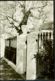 Kew Historical Society Inc
Photograph - House, Highbury Grove, Kew, Nita Green, 1979
Nita Green was a member the Society and owner of Reno in St John's Parade, Kew. She was clearly a skilled photographer from the examples of photographs taken by and processed by her.Front fences of two two-storey houses at the south end of Highbury Grove. The cast iron pickets have since been replaced by high brick walls."Front entrance to home Highbury Grove opposite former Presbyterian Hall & Manse / Donated by and taken by Nita Green, 1979"houses -- highbury grove -- kew (vic.), fences -- kew (vic.) -
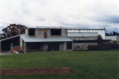 Whitehorse Historical Society Inc.
Photograph, Nunawading Recreational Centre
Fund raising by the Rotary Club of Nunawading and a Public Works grant led to the completion of the Nunawading Recreation Centre, Silver Grove, Nunawading in 1976Coloured photo showing the southern side of the Nunawading Recreational Centre, Silver Grove, Nunawading. Taken in 1980'snunawading recreation centre, recreation facilities -
 Bendigo Historical Society Inc.
Functional object - BOTTLES COLLECTION: GROVES MCVITTY CO
Blue castor oil bottle with thin neck screw top mouth. Moulded into the glass are the words ''GROVES McVITTY & Co. PTY LTD. CASTOR OIL''. A moulded stamp on the base of the bottle has the letters and numbers ''D661 GM.'' The base is 4 cm in diameter and the bottle is 20 cm high.''Groves McVitty & Co. Pty Ltd. Castor Oil'' ''D661 GM.''food technology, bottling, castor oil bottle -
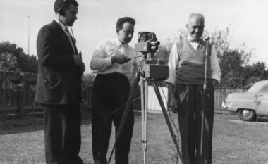 Ithacan Historical Society
Photograph, Angelo Petalas and Stathi Raftopoulos, 1956
Stathi Raftopoulos (middle) and Angelo Petalas (left) and a Mr Palaris are pictured filming at Madden Grove Kew. Both Stathi and Angelo were passionate about cinema. Stathi brought Greek cinema to Melbourne and Angelo ran the Melbourne University Cinema. Angelo's son Kim Petalas has carried on his father's passion and is the National Programming Director for Palace Cinemas.Black & white photograph with white crinkled border of 3 men with a movie camera. -
 Kew Historical Society Inc
Photograph - Flooding of the Yarra River in North Kew, 1934
North Kew, now divided between Kew and Kew East, bordered the Yarra River. As such, it was a region subject to flooding in the Yarra Valley. Development beyond this point (ie Kellett Grove) was limited by the City of Kew's planning regulations. Prior to urban development, the area since European settlement and the first land sales in the district in the 1840s, had been used for dairy farming. Small sepia snapshot of floodwaters taken from near Willsmere Road, in what was then known as North Kew. The point of view is looking towards Fairfield. In the foreground are two figures viewing a group in a rowboat in the middle of the flooded river. Semi-submerged street lighting indicates that entire streets had been. overwhelmed by the flood waters. Verso: WILLSMERE ROAD NORTH KEW / Stamped 3 163yarra river -- north kew, floods -- yarra valley, floods -- north kew, floods -- 1934, natural disasters -- kew, willsmere road -
 Kew Historical Society Inc
Photograph - Flooding of the Yarra River in North Kew, 1934
North Kew, now divided between Kew and Kew East, bordered the Yarra River. As such, it was a region subject to flooding in the Yarra Valley. Development beyond this point (ie Kellett Grove) was limited by the City of Kew's planning regulations. Prior to urban development, the area since European settlement and the first land sales in the district in the 1840s, had been used for dairy farming. Small sepia snapshot of floodwaters in North Kew. The point of view is of two houses belonging to local families that were surrounded by floodwater. Verso: HYATTS HOUSE / WILLSMERE ROAD / Stamped 3 163yarra river -- north kew, floods -- yarra valley, floods -- north kew, floods -- 1934, natural disasters -- kew, willsmere road -
 Kew Historical Society Inc
Photograph - Flooding of the Yarra River in North Kew, 1934
North Kew, now divided between Kew and Kew East, bordered the Yarra River. As such, it was a region subject to flooding in the Yarra Valley. Development beyond this point (ie Kellett Grove) was limited by the City of Kew's planning regulations. Prior to urban development, the area since European settlement and the first land sales in the district in the 1840s, had been used for dairy farming. .Small sepia snapshot of a local family's house in what was then River Avenue, North Kew being surrounded by floodwaters.Verso: THE SIDE OF RYANSyarra river -- north kew, floods -- yarra valley, floods -- north kew, floods -- 1934, natural disasters -- kew -
Glen Eira Historical Society
Document - Robertson, Alexander William
Two items. Photocopied typed pages from the National Trust of Australia, includes forty-two poor copies of family photographs and a summary of information about Alexander William Robertson and LABASSA. 2 Manor Grove, Caulfield, by C. Kelloway, dated 03/02/1981. One handwritten page of references relating to Alexander William Robertson, life and business connections, undated, author unknownrobertson a.w., ontario, labassa, billing richard annersley, orrong road, cobb and co., coaches, house names, judge, carriers, robertson emily davidson, pastoralists, robertson hannah elizabeth goldsburgh, caulfield, mansion houses, goldsbrough and co., wool industry, koch j.a.b., architects -
Glenelg Shire Council Cultural Collection
Photograph - Photograph - Portland Harbour group of men on ship, 1982
Port of Portland Authority ArchivesBack: 'Stan Groves - - - Mick Krisik, Ron Waters, Ian Baird Maiden voyage ? ick Wing '82 - blue biroport of portland archives, stan groves, mick krisik, ron waters, ian baird -
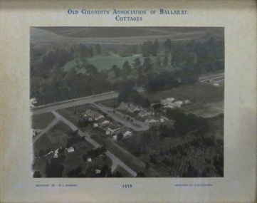 Old Colonists' Association of Ballarat Inc.
Photograph - Photograph - Colour, N.L. Harvey, Old Colonists' Association of Ballarat Cottages, 1958, 1958
Aerial Photograph of the Old Colonists' Association of Ballarat Cottages at Charles Anderson Grove. One of the first objectives of the Association was "to provide the shelter of a hose for those Pioneers of the Goldfields whom the reverses of fortune have deprived of the means of procuring the comforts of life in their declining years." The first home at Charles Anderson Grove was built in 1925. Before that time the Association provided relief for needy pioneers. relief included monthly monetary payments, loads of firewood, medical assistance and distribution of Christmas bosed of groceries to deserving pensioners, and in some cases payment of burial costs. ::a) The dominant purpose of the Association is to give public benevolent relief as a charity, but providing independent living accommodation in our Retirement Village for person in need who are over 65. ::b) To raise funds by membership subscription, commercial and residential rents, donations, gifts and voluntary work, for the purpose of providing direct relief of poverty, distress, misfortune or helplessness. ::c) To maintain the important heritage and ongoing viability of the Old Colonists' Association. (Revised Rules of the Old Colonists' Association of Ballarat Inc., 2016) old colonists' association, ballarat, charles anderson grove, retirement village