Showing 53515 items matching "hobsons-bay-city-council"
-
 Camberwell Historical Society
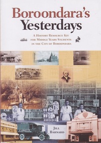
Book, Jill Barnard, Boroondara's Yesterdays: a history resource kit for middle years students in the City of Boroondara, 2009
The book is designed to help middle years students in the Boroondara area to understand and discover more of the local history of their citycamberwell, boroondara -
 Camberwell Historical Society
Document (Item) - Report, City of Boroondara, City of Boroondara Annual Report 2000, 2000
boroondara -
Canterbury History Group
Book, City of Camberwell, Pictures of Camberwell: a Progressive City
The book demonstrates with black and white photographs and text the progression of the Shire of Boroondara into the City of Camberwell, with a foreward by Gwen McWilliamnon-fictioncamberwell, burwood, glen iris, ashburton, canterbury, surrey hills, balwyn, deepdene, north balwyn, mcwilliam> gwen -
 Greensborough Historical Society
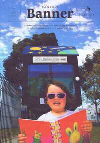
Magazine, Banyule City Council, Banyule Banner May June 2015, 2015_05
The Banyule Banner is published quarterly by Banyule City Council to advertise upcoming events in the City of Banyule and to report on past events. This edition includes information on new local laws, the Greensborough Structure Plan review, activities for children and a reflection on the centenary of Gallipoli.A record of events within the City of Banyule.20 pages (approx.), colour illustrations.banyule city council -
Greensborough Historical Society
Magazine, Banyule City Council, Banyule Banner May/June 2013, 2013_05
The Banyule Banner is published quarterly by Banyule City Council to advertise upcoming events in the City of Banyule and to report on past events. This edition includes information on Hatch contemporary arts space. St Helena Bush Reserve, and several articles on tree protection.A record of events within the City of Banyule.20 pages, with colour illustrations.banyule city council, banyule banner -
 Ringwood and District Historical Society
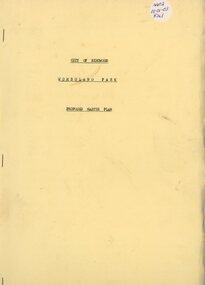
Book, Wombolano Park, 1973
Wombolano Park - City of Ringwood Proposed Master Plan - 1973 -
Port Melbourne Historical & Preservation Society
Document, Jan HARPER, Sugar and Starch to Sandridge Bay Towers, 2023
Jan HARPER's document covers the history of the building from the Victorian Sugar Works to Harper's Starch Factory to Sandridge Bay Towers.White oblong 26 page publication with colour photograph of Sandridge Bay Towers on the cover.sandridge bay towers, harpers starch factory, victorian sugar works -
 Greensborough Historical Society
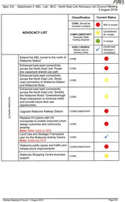
Document, Advocacy list (North East Link), 05/08/2019
Attachment to Item 5.6, Ordinary meeting of Council 5 August 2019, discussing the North East Link and possible impacts on the City of Banyule, including Watsonia.5 pages, typescriptnorth east link, watsonia station, watsonia -
 Greensborough Historical Society
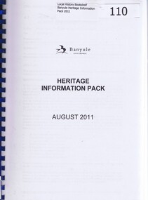
Book, Heritage Information Pack August 2011, 2011_08
This is an updated draft of Banyule City Council's "Heritage Policy and Plan". Its purpose is "To give strategic direction for improved understanding, protection and promotion of Banyule's heritage"This document lists sites in the City of Banyule assessed for their heritage value.261 pages plus appendices. Photocopied A4 book on white paper with red pages interleaved. Blue spiral binding, clear front cover and brown card back cover.bnayule city council, banyule heritage review -
 Greensborough Historical Society
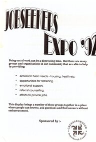
Flyer - Leaflet, Greensborough Inter Church Council, Greensborough Interchurch Council. Jobseekers Expo '92, 1992
The Greensborough Interchurch Council sponsored a Jobseekers program in the 1990s. These leaflets outline services available, including a database to match job seekers with employers.2 p. Black text on blue paper; blue text on white papergreensborough interchurch council, jobseekers, employment programs -
 Greensborough Historical Society
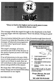
Pamphlet - Newsletter, Greensborough Inter Church Council, Greensborough Interchurch Council News. Summer 1992, 1992
The Greensborough Interchurch Council Newsletter (Summer 1992) reviews past activities and advertises coming events, including Christmas services at participating Churches.4 p., black text on cream paper.greensborough interchurch council, church services, newsletters -
 Robin Boyd Foundation
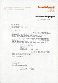
Letter, Australia Council, Australia Council to Patricia Davies, 13.09.1979
A letter from A. Johnson, Public Lending Right, Australia Council to Patricia Davies (formerly Boyd), regarding a request for tracing authors or their heirs.Answered 10/9/79 in pen. -
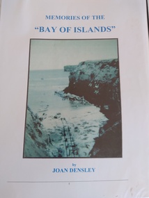 Peterborough History Group
Book, Memories of the Bay of Islands + Crofts Bay Huts
Early use of Crown Land for holiday makers prior to the Great Ocean Road extension, when leaseholders were forced to relinquish their land and houses. Includes a list of the names of occupants at that time. Also includes letters from the Crown Lands Dept about the efforts to retain the Crofts Bay Huts.Significant because it is an eyewitness description of the huts which were demolished in the mid 1970's. Also describes holiday activities and mentions other families in the area.Folder containing the photocopy of the book by Joan Densley and the separate story of the Crofts Bay huts.including copies of Crown Land documents and letters. Includes copy of photographs of the huts and beach.peterborough, crofts bay, bay of islands, joan densley, great ocean road, crofts bay huts, bay of islands huts -
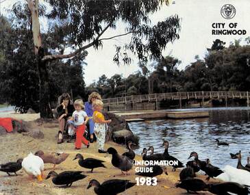 Ringwood and District Historical Society
Booklet, City of Ringwood Information Guide 1983, 1983
Community information booklet issued by City of Ringwood for 1983 - covering the facilities and activities of the Ringwood Council and other local organisations and associations. Cover photograph: Ringwood Lake Reserve.CONTENTS: (page no.) Aged — Centre for the Frail Aged 22 Building — General Information 28 By-Laws and Regulations 27 Circuit Bus — Ringwood City 33 Commissioners for taking Declarations and Affidavits 29 Committees of Council 6 Council Meeting Dates 6 Council Officers 8 Council Representation 7 Councillors 4 Cultural Centre 36 Disabled Persons - Facilities 21 Emergency Telephone Numbers 58 Elections for Council 10 Festival 23 Finance - Council 11 Garbage Collection 58 Golf Course 37 Health 18 Home Help 25 Immunisation Programme 20 Immunisation Schedule 19 Items of Interest 32 Justices of the Peace 29 Lake — Ringwood Lake Reserve 59 Leisure Areas 16 Library — General 12 Library - Service for our Senior Citizens 26 Major Works Programme 14 Map of Municipality 30 Mayor’s Message – Cr. Pat Gotlib, J.P. 2 Meals on Wheels 24 Members of Parliament 56 Nature Strip Maintenance 34 Pensioners — Rate Assistance 11 Rates 10 Recycling of Waste 57 Roll — Municipal 10 Shuttle Bus 33 Swimming Centre 37 Voting — Compulsory 10 Welfare and Community Services 38 rinx -
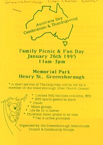 Greensborough Historical Society
Flyer - Article and Leaflet, Greensborough Inter Church Council, Greensborough Interchurch Council. Family picnic and fun day 26/01/1995, 26/01/1995
The Greensborough Interchurch Council organised a family picnic and fun day on Australia Day 26/01/1995. Leaflet advertising the event and article by Rosie Bray2 p. Leaflet: blue text on yellow paper; article: black text on white papergreensborough interchurch council, australia day, picnics in greensborough -
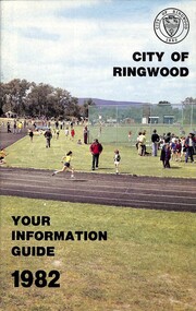 Ringwood and District Historical Society
Booklet, City of Ringwood - Your Information Guide 1982, 1982
Community information booklet issued by City of Ringwood for 1982 - covering the facilities and activities of the Ringwood Council and other local organisations and associations. Cover photograph: A.C. Robertson Athletic Field. CONTENTS: (page no.) Beautification and Leisure Areas 16 Building — General Information 26 By-Laws 27 Circuit Bus — Ringwood City 54 Commissioners for taking Declarations and Affidavits 31 Council Meeting Dates 6 Council Representation 7 Councillors 4 Cultural Centre 32 Disabled Persons - Facilities 34 Elections for Council 10 Emergency Telephone Numbers 54 Festival 33 Finance — Council 12 Golf Course 30 Health Home Help Service 24 Immunisation Programme 20 Items of Interest 22 Justices of the Peace 30 Library — General 13 Library — Service for our Senior Citizens 26 Major Works Programme 14 Map of Municipality 28 Mayor's Message – Cr. N.J. Hamilton 2 Meals on Wheels 25 Members of Parliament 52 Officers of the Council 8 Property Records 10 Rates 11 Recycling Depots S3 Regulations 27 Roll — Municipal 10 Swimming Centre 21 Voting — Compulsory 10 Welfare and Community Services 35 rinx -
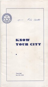 Melbourne Tram Museum
Pamphlet, City of Box Hill, "Know Your City", 1969 to 1973
Set of five pamphlets titled "Know your City", issued early 1970's by the City of Box Hill contained with a white card folder. .1 - white card folder stapled on the right hand edge to contain the pamphlets with the City logo - dated 11/73 .2 - No. 1 - the Box Hill - Doncaster Tram - 3rd edition - 9/69 - see Reg Item 869 for a later version. .3 - No. 2 - The White Horse - 4th edition 12/73 .4 - The Woodhouse Grove Methodist Church - 2nd edition 9/71 .5 - Local Government in Box Hill - 4th Edition 10/73 .6 - Historical Dates - 2nd edition - 5/72 .7 - City of Box Hill - 1973-1974 - folded sheet detailing the activities of the City, budgets and a message from the Mayor. See Reg Item 2534 for an A3 and larger version of .2..1 - has noted "File Under" written in ink on front cover.trams, tramways, box hill, doncaster -
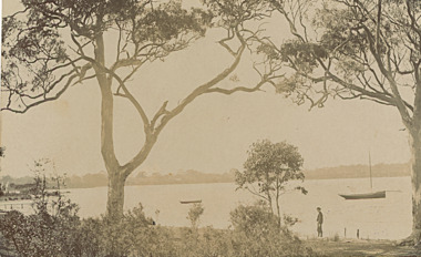 Lakes Entrance Historical Society
Postcard, Bancroft Bay Metung Victoria, 1900 c
Two small boats moored in bay person standing on shoreSepia toned postcard taken from waterfront looking across Bancroft Bay towards Boole Poole Metung Victoria boats and boating, jetties, waterways -
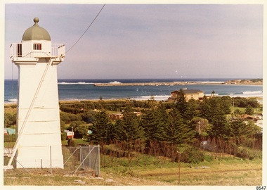 Flagstaff Hill Maritime Museum and Village
Photograph - Historical, Flagstaff Hill, John Lindsay, View of the Bay from the south boundary of the Ports and Harbours land, 1970s
The photograph shows the view of the shore and Lady Bay with the Breakwater and Middle Island all visible. It was taken to show that the Flagstaff Hill area was unlikely to have any further development between it and the Bay, with the view of development of the Flagstaff Hill Maritime Museum and Village. This photograph, a print, is one of a set of five that show the site of Flagstaff Hill. The photographer was John Lindsay, Founding Director of Flagstaff Hill Maritime Museum and Village, with the words "Photo J Lindsay" on the back. It was taken in the early 1970s during the initial stages of the development of Flagstaff Hill as a Museum and Maritime Village. The photographs belonged to the donor's grandparents, who lived in the Warrnambool district of Allansford/Naringal. The photograph is a record of the site and surrounds of Flagstaff Hill Maritime Museum and Village before its development and opening in 1975. It shows the Surfside Holiday Park, Surf Lifesaving Club, and the Breakwater. The photograph is significant for recording the location and condition of the Lower Lighthouse on the Hill.Coloured photograph, glassy print, one of a set of five. Flagstaff Hill's Lower Lighthouse is in the foreground above the Surfside Holiday Park. To the right of centre is the Surf Lifesaving Club. In the background is Lady Bay and the Breakwater and Middle Island, with the Southern Ocean the other side. The photograph's paper has the printer's watermark and a pencilled inscription on the back. The early 1970s scene was photographed by John Lindsay, Warrnambool.Label on the back: "VIEW OF THE BAY FROM the southern boundary of the Ports and Harbours land. No development below this area is likely to obstruct the view, due to the steep grade down to the Southern boundary of Flagstaff Hill property." Handwritten in pencil: "Photo J Lindsay"flagstaff hill, flagstaff hill maritime museum and village, warrnambool, maritime museum, maritime village, great ocean road, shipwreck coast, 1970s, photograph, surfside holiday park, lady bay, flagstaff hill site, john lindsay, lower lighthouse, lower light, surf lifesaving club, breakwater, middle island, ports and harbours -
 Warrnambool and District Historical Society Inc.
Document - Mayor’s Annual Report, Warrnambool City Council, 1981
This is a copy of the Mayoral Report of the Mayor of Warrnambool (John Lindsay) 1980-1981. It contains much interesting information on the activities of the Warrnambool City Council during the years 1980-1981. This report is of minor interest as it is a copy of a report available from other sources. It may be a useful file for researchers. These are 40 pages of typewritten material (foolscap size). The pages were stapled but the staple has been removed,warrnambool, john lindsay, warrnambool mayor, mayorsl report 1981 -
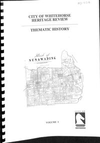 Whitehorse Historical Society Inc.
Book - City of Whitehorse Heritage Review, Allom Lovell & Associates, April 1999
Heritage Review of the City of Whitehorse April 1999 by Allom Lovell & AssociatesCity of Whitehorse Heritage Review; prepared by Allom Lovell & Associates for City of Whitehorse, April 1999 Volume 1: Thematic History Volume 2: pt 1: Datasheets A - K Volume 2: pt 2: Datasheets L - Z Volume 3: Heritage Overlay Precincts Volume 4: Heritage Overlay Schedulecity of whitehorse, commercial buildings, buildings, historic buildings and sites, churches, resential development -
 Ballarat Tramway Museum
Document - Report, City of Ballaarat, "Submission to Enquiry into Public Transport Facilities in the Ballarat Urban District by A. W. Nicholson, Mayor of Ballaarat Council", Apr. 1968
Yields information about the view of the City of Ballaarat in 1968 about the possible replacement of tram service.Report or Submission - 6 Gestener printed foolscap sheets, stapled on left hand side and bound with a blue edging tape titled "Submission to Enquiry into Public Transport Facilities in the Ballarat Urban District by A. W. Nicholson, Mayor of Ballaarat Council". Dated 2 April 1968. Submission looks at the possible closure or the future of the tramway system, the SEC involvement, employment, road surface repairs, financial loss to the SEC, reduction in passengers due to car ownership. Council submitted that the tramway system should be retained and extended and that pensioner concessions should be continued. Notes that at the time 69 men on the trams, 18 at the depot and 8 on the track. If replaced by buses, supported a government owned bus provider rather than private. Document scanned - word searchable. pdftrams, tramways, closure, city of ballaarat, bus replacement, public transport, sec, finances -
 Otway Districts Historical Society
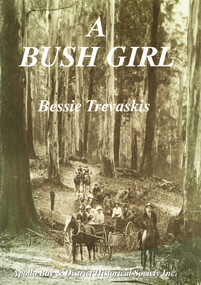
Book, Apollo Bay & District Historical Society Inc, A Bush Girl, December 2001
A family history about the Holmes family and one daughter's marriage to Mark Trevaskis between 1897 and 1912.A Bush Girl. A story about life in the Otway ranges between 1897 and 1912. Eveline Bessie Orlina Trevaskis. Apollo Bay; Apollo Bay & District Historical Society; 2001. vi, 64 p.; illus, maps. Soft cover. ISBN 0 9577956 2 9a bush girl; bessie trevaskis; otway ranges; family history; barramunga; wongarra; -
 Greensborough Historical Society
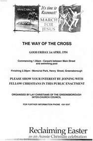
Programme - Booklet, Greensborough Inter Church Council, Greensborough Interchurch Council. The way of the cross. Good Friday 01/04/1994, 01/04/1994
The Greensborough Interchurch Council held a Way of the Cross service on Good Friday 01/04/1994. Includes a press release and 4 newspaper clippings of local Easter services and community activities.8 p., black text on white paper, green cover, stapled in top left corner.greensborough interchurch council, church services, easter, way of the cross -
Glen Eira City Council History and Heritage Collection
Document (Item) - Newspaper (digital), Glen Eira City Council, Glen Eira News, 2004
The Glen Eira news is the official newspaper of the City of Glen Eira from 1995 to present day. The City of Glen Eira is the Municipal Council for an area of the South Eastern suburbs of Melbourne, including Bentleigh, Bentleigh East, Brighton East, Carnegie, Caulfield, Elsternwick, Gardenvale, Glen Huntly, McKinnon, Murrumbeena, Ormond and St Kilda East. Prior to the amalgamation of City of Caulfield and parts of the City of Moorabbin in 1994, the Glen Eira News was preceded by the Caulfield Contact Monthly. glen eira, city of glen eira, bentleigh, bentleigh east, brighton east, carnegie, caulfield, elsternwick, gardenvale, glen huntly, mckinnon, murrumbeena, ormond, st kilda east -
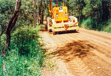
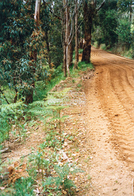
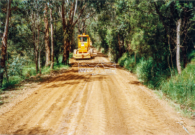
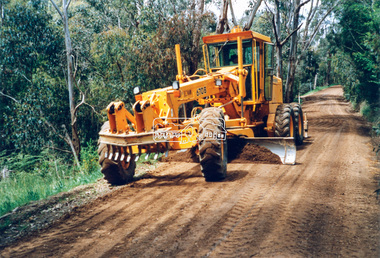 Eltham District Historical Society Inc
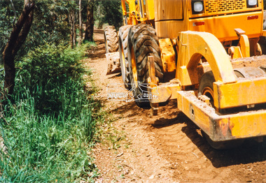
Photograph - Colour Print, Eltham Shire Council, Council oerations road grading and gravel water truck, c.1990
The cost of providing equivalent levels of services to the more rural areas of the Shire with respect to those in the more urban areas of Eltham, Montmorency and Briar Hill was relatively expensive. Road maintenance of rural unsealed gravel roads is one of those areas of higher costs particulary as a result of water erosion. The same applies for Nillumbik Shire Council today. Here we see Council operations grading a road and laying new gravel, followed by a gravel water truck to help bed the surface down. Unfortunately there is no information with these prints as to where this particular location is.graders, infrastructure, road maintenance, roads, shire of eltham, rural road, unidentified -
 Eltham District Historical Society Inc
Photograph - Colour Print, Eltham Shire Council, Council oerations road grading and gravel water truck, c.1990
The cost of providing equivalent levels of services to the more rural areas of the Shire with respect to those in the more urban areas of Eltham, Montmorency and Briar Hill was relatively expensive. Road maintenance of rural unsealed gravel roads is one of those areas of higher costs particulary as a result of water erosion. The same applies for Nillumbik Shire Council today. Here we see Council operations grading a road and laying new gravel, followed by a gravel water truck to help bed the surface down. Unfortunately there is no information with these prints as to where this particular location is.graders, infrastructure, road maintenance, roads, shire of eltham, rural road, unidentified