Showing 648 items
matching local water
-
 Kew Historical Society Inc
Journal, Kewriosity : July 1991
Not blowing in the wind [recycling paper] / p1. Completing the picture [Disability access at The Alexandra Gardens] / p1. Business seminar / p1. Manna from the heavens [water consumption and water rates] / p1. Willsmere go-ahead [Jennings development] / p1. Diary dates for July / p2. Winter: a good time for bushwalking [Kew Bushwalkers Club] / p2. Kinder's 40th [J.J. McMahon Memorial Kindergarten] / p2. Study Camp / p2. Commentary / Cr Daryl Oldaker / p3. Chief Executive's Column [amalgamation of local government entities] / Malcolm Hutchinson p3. Your chance to stand [Council elections] / p4. Letter to the editor [Kew Junction] / Tim Warmington p4. Looking into windows [Property revaluations] / p4. Mayor opens park [bicycle path in Outer Circle Linear Park] / p4. Gisborne passes this motion [Dog Act] / p4. Traffic Management updates - Speed cameras? [Area 6, Area 7, Area 10] / p5. Nit picking again [new head lice brochure] / p5. Concerned about possums? / p5. Your tobacco taxes at work / p5. Taste it ... you'll like it [Beatrix Potter] / p6. Literacy programmes [Kew Community House programmes] / p6. Royal Guide Dogs needs your help / p6. Youth Leadership course / p6. Rock bottom prices [petrol price competition] / p7. Arthritis AGM [Kew Arthritis Self Help Group] / p7. Cheque for Blind Mission [fundraising for Christian Blind Mission International by Carey Grammar School] / p7. Live comedy at Hartwell [Hartwell Players] / p8. Peel Street Anniversary [Sir Robert Peel PM] / p8. Holeproof factory future [Holeproof Hosiery plant in Surry Hills] / p8. What topics arose? [architectural and garden roses] / p8.Kewriosity was a local newsletter combining Kew Council and community news. It was published between November 1983 and June 1994, replacing an earlier Kewriosity [broad] Sheet (1979-84). In producing Kewriosity, Council aimed to provide a range of interesting and informative articles covering its deliberations and decision making, together with items of general interest and importance to the Kew community and information not generally available through daily media outlets.non-fictionNot blowing in the wind [recycling paper] / p1. Completing the picture [Disability access at The Alexandra Gardens] / p1. Business seminar / p1. Manna from the heavens [water consumption and water rates] / p1. Willsmere go-ahead [Jennings development] / p1. Diary dates for July / p2. Winter: a good time for bushwalking [Kew Bushwalkers Club] / p2. Kinder's 40th [J.J. McMahon Memorial Kindergarten] / p2. Study Camp / p2. Commentary / Cr Daryl Oldaker / p3. Chief Executive's Column [amalgamation of local government entities] / Malcolm Hutchinson p3. Your chance to stand [Council elections] / p4. Letter to the editor [Kew Junction] / Tim Warmington p4. Looking into windows [Property revaluations] / p4. Mayor opens park [bicycle path in Outer Circle Linear Park] / p4. Gisborne passes this motion [Dog Act] / p4. Traffic Management updates - Speed cameras? [Area 6, Area 7, Area 10] / p5. Nit picking again [new head lice brochure] / p5. Concerned about possums? / p5. Your tobacco taxes at work / p5. Taste it ... you'll like it [Beatrix Potter] / p6. Literacy programmes [Kew Community House programmes] / p6. Royal Guide Dogs needs your help / p6. Youth Leadership course / p6. Rock bottom prices [petrol price competition] / p7. Arthritis AGM [Kew Arthritis Self Help Group] / p7. Cheque for Blind Mission [fundraising for Christian Blind Mission International by Carey Grammar School] / p7. Live comedy at Hartwell [Hartwell Players] / p8. Peel Street Anniversary [Sir Robert Peel PM] / p8. Holeproof factory future [Holeproof Hosiery plant in Surry Hills] / p8. What topics arose? [architectural and garden roses] / p8.publications -- city of kew (vic.), kewriosity, council newsletters, community newsletters -
Kew Historical Society Inc
Journal, Kewriosity : June 1989
First step before school [Kew Kindergartens] / p1. Hard garbage, hard time / p1. Dates for June / p2. Holiday programs for Kew youngsters / p2. Kids skills for Kew [Kew Recreation Centre] / p2. Commentary / Cr Allen Martin p3. Master plan to beautify streets / p3. Service Review for St George's [Hospital] / p2. Temporary move for Hawthorn Library / p2. Notices / p4. Council elections / p4. Local College plays host to interstate sports [MLC] / p4. Learning for leisure [Kew Recreation Centre] / p4. Mother's Day gift for Kew's older mums / p5. Disability no barrier to water fun / p5. Easter treat for senior locals / p5. A day in the life of Community House / p6. Environment queries to Science Shop shows community cares / p6. Outward bound [Kew Arthritis Self Help Group] / p6. Xavier Chapel story features in new book / p7. Green Spot - An alternative way to shop / p7. Boroondara Bushwalkers / p8. Teenage Holiday Program / p8. Footy News [Kew Football Club] / p8. [Neighbourhood Watch] Meetings for June / p8. Keeping you informed [Citizens Advice Bureaux] / p8.Kewriosity was a local newsletter combining Kew Council and community news. It was published between November 1983 and June 1994, replacing an earlier Kewriosity [broad] Sheet (1979-84). In producing Kewriosity, Council aimed to provide a range of interesting and informative articles covering its deliberations and decision making, together with items of general interest and importance to the Kew community and information not generally available through daily media outlets.non-fictionFirst step before school [Kew Kindergartens] / p1. Hard garbage, hard time / p1. Dates for June / p2. Holiday programs for Kew youngsters / p2. Kids skills for Kew [Kew Recreation Centre] / p2. Commentary / Cr Allen Martin p3. Master plan to beautify streets / p3. Service Review for St George's [Hospital] / p2. Temporary move for Hawthorn Library / p2. Notices / p4. Council elections / p4. Local College plays host to interstate sports [MLC] / p4. Learning for leisure [Kew Recreation Centre] / p4. Mother's Day gift for Kew's older mums / p5. Disability no barrier to water fun / p5. Easter treat for senior locals / p5. A day in the life of Community House / p6. Environment queries to Science Shop shows community cares / p6. Outward bound [Kew Arthritis Self Help Group] / p6. Xavier Chapel story features in new book / p7. Green Spot - An alternative way to shop / p7. Boroondara Bushwalkers / p8. Teenage Holiday Program / p8. Footy News [Kew Football Club] / p8. [Neighbourhood Watch] Meetings for June / p8. Keeping you informed [Citizens Advice Bureaux] / p8.publications -- city of kew (vic.), kewriosity, council newsletters, community newsletters -
 Kew Historical Society Inc
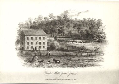
Print, Dight's Mill, Yarra Yarra
"In 1839 John Dight purchased Melbourne block 88, which included 26 acres of land along the Yarra River for £481 at the Port Phillip land sales held in Sydney. Dight was already in the business of flour milling and had a mill near Campbell Town in New South Wales called ‘Ceres’. In April 1840, he notified his customers through The Sydney Herald that he was leaving to go to Port Phillip. The first steam powered flour mill was constructed in Melbourne in 1841. Dight built his water powered mill, soon after, from bricks bought over from Tasmania. Dight used the river to power his mill: Water flowed along an inlet channel to turn an undershot water wheel. In order to regulate flow or to ensure flow for times when river levels were low, Dight constructed a rough stone weir. " (https://www.melbournewater.com.au/whatwedo/projectsaroundmelbourne/Documents/A_Short_History_of_Dights_Falls_Fact_Sheet.pdf) This work forms part of the collection assembled by the historian Dorothy Rogers, that was donated to the Kew Historical Society by her son John Rogers in 2015. The manuscripts, photographs, maps, and documents were sourced by her from both family and local collections or produced as references for her print publications. Many were directly used by Rogers in writing ‘Lovely Old Homes of Kew’ (1961) and 'A History of Kew' (1973), or the numerous articles on local history that she produced for suburban newspapers. Most of the photographs in the collection include detailed annotations in her hand. The Rogers Collection provides a comprehensive insight into the working habits of a historian in the 1960s and 1970s. Together it forms the largest privately-donated collection within the archives of the Kew Historical Society.An engraving of Dight's Mill on the Yarra. The image was originally published in Sands & Kenny, Melbourne & Sydney. Dorothy Rogers reproduced the print in 'A History of Kew' (1973). It faces page 8.Published by Sands & Kenny, Melbourne & Sydney, 1856dight's mill, dorothy rogers, dight's falls, yarra river, kew, john dight -
 Kew Historical Society Inc
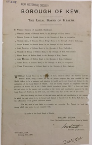
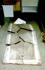
Document, Holland Loxton, Notification to the Residents of Derrick Street by the Local Board of Health, 1885, 1885
Streets and drains were the basic infrastructure problems for Kew in the 1880s. Decent streets and drains were fundamental to the quality of life of the residents. Without drainage, streets became muddy, boggy and sometimes impassable. Pools and puddles of stagnant water became smelly. The run off water, mixed with human and animal wastes, because there was no sewerage, became a health hazard. Streets and drains then became what were known as 'a nuisance'. Kew suffered from bouts of typhoid fever during the 1880s. Derrick Street was a private street on the margin of the business district of Kew and a well-used thoroughfare. We hear first about Derrick Street when the ratepayers applied to Council to have the street 'taken over' in January 1881. The Council agreed, after much debate, but ratepayers had to pay half the costs. The argument of the majority of the Council was that there was an established policy that ratepayers of private streets either had to hand over the street fully-formed or pay half the costs if Council did the work. It was felt that to make an exception for Derrick Street would create a precedent for ratepayers of other private streets. On the other hand the ratepayers, and a minority of Council, believed that there were extenuating circumstances in the case of Derrick Street. They believed that the costing by the Borough Surveyor was excessive. They felt the Council was partly responsible for the state of the street due to a channel on Bulleen Road, which deposited sand in the street. The Council had also put in some kerbing at the entrance to the street. Finally, the ratepayers believed that the street had become an important and convenient thoroughfare in Kew, and thus should be an exception to the policy on private streets. In the end a decision was delayed to allow the ratepayers to drain and form the street themselves. And there the matter stood till September 1882, when Miss Reilly complained about rubbish on a block of land in Derrick Street. So, in October 1882 the Council agreed to take over and form the street with the ratepayers paying half the costs. The ratepayers did not want to pay, so the argument continued in Council into 1883. There was a standoff for a further 18 months, until the problem could no longer be ignored. In October 1884 the Inspector of Nuisances and the Health Officer reported that Derrick Street was a health hazard as there was no drainage outlet for waste water. These reports changed the status of the problem of Derrick Street. It became an issue of public health, and thus the Council, acting as the Local Board of Health, had power to prepare plans and order the ratepayers to drain the street and pay all the costs, or let the Council do the work and charge ratepayers half the costs of the works. By April 1885, the time for ratepayers to complete the works themselves had expired, so the Council proceeded with the work and required ratepayers to pay for their share of the costs. All ratepayers had paid by the end of April except Mr Whiddycombe, who refused to pay. Mr Whiddycombe was warned to pay in October 1885. Legal action was taken against him in November. The Council lost the case on technical grounds. The Council, acting as the Local Board of Health, relaunched the legal action and won. The last we hear of Derrick Street is that seven day’s notice was given to Derrick Street ratepayers to pay for the drainage works in May 1887. We presume that Mr Whiddycombe paid. (Research: Andrew Frost)Rare and historic publication issued by the Board of Health in the Borough of Kew in 1885 to residents of Derrick street regarding the need for proper drainage for the purpose of improving public health.Printed formal notice sent by the Board of Health of the Borough of Kew to landowners in Derrick Street, Kew. The notice advised the owners that they were required to form and drain the street according to the levels and specifications approved by the Board. The letter was sent on January 23rd 1885, and signed by the Inspector of Nuisances.borough of kew -- greater melbourne (vic.), council notices -- public health, derrick street -- kew (vic.) -
 Kew Historical Society Inc
Photograph, Edwin Anderson, 1st Kew Scouts, Water Rescue Training, 1924
The 1st Kew Scouts was one of the first Scout Troops in Victoria, being formed in 1909. From 1927 they met in a magnificent Scout Hall in Disraeli Street, Kew until it was demolished in 1993. Still operating (in 2020) from their new Scout Hall on the corner of Kilby Road and Kellett Grove, Kew.1st Kew Scouts undertaking water rescue training at Bulleen. The photograph was most likely taken while the Scouts were camping beside the river one summer, with the programs generally including not only fun and games but also varying training activities. At the time many locals swam in the river. 1924 was well before the construction of major water storage dams and urbanisation of the upper reaches of the Yarra River, which significantly reduced downstream flows and water quality. These days, the Scouts tend to raft and canoe in the Yarra, rather than swim. On front: 1924. On reverse: photographer's stampscouts - kew, 1st kew scouts, yarra river, bulleen, water rescue training 1924 -
 Kew Historical Society Inc
Headwear - Green Cotton & Yellow Silk Ribbon Smoker's or Lounge Cap, 1860s
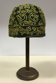
The context in which the hat was made and worn assists in establishing its potential historic significance. 'Bailliere's Victorian Gazetteer and Road Guide containing the most recent and accurate information as to every place in the Colony' (1870), describes the village of Vaughan as being located on the road from Daylesford to Castlemaine. In 1870 the Vaughan was deemed to be entirely a gold mining area, gold having been discovered in the district in 1853. Intriguingly the entry in the Gazetteer claims that the electoral division of Vaughan began at the junction of the Middleton Creek and the Loddon River, so perhaps the cap might have belonged to a member of a significant local family. In 1870, Vaughan had a population of about 1000 persons and included almost 300 dwellings. Articles from newspapers, published on Trove refer frequently to a Mr Middleton as a litigant in court cases before the Vaughan Court in the 1860s. By the 1870s, the Mt Alexander Mail, in an article on ‘Mining: The Pioneer Wheel’ describes the success of Mr Middleton and his Middleton’s Reef Gold Quartz Mining Company, which had built the largest water wheel in the Colony. The wheel was 20’ in diameter and 2’ wide. Quartz mining as practiced by companies such as Middleton’s had become necessary after the exhaustion of alluvial quartz mining deposits in the 1860s. So we can probably establish a link between the cap and a significant mining identity in the period in which the article was made. The historical significance of the cap is only one part of the story. Caps such as the Middleton example can also be items of aesthetic significance as they were typically, examples of women’s work, using published patterns in magazines such as the Ladies Home Magazine. While women might follow or adapt a published pattern, their choice of materials reflected what was available locally. The fine hand stitching on this example is evidence of high quality domestic needlework. The maker crafted the cap from five triangular pieces of cotton cloth, each piece lined with a faded yellow net. The net provides some stiffening for the cap and has a functional purpose in that it anchors the hand-stitched, looped design of yellow silk ribbon that decorates the surface of the cap. Gentleman’s smoking (lounging) cap believed to have been made in c.1860-69. The conical hat is made of a dark green cotton fabric embroidered with narrow ribbon of a paler green silk. The unlined rimless hat is made of four pieces of fabric. There is no evidence of the hat at one stage featuring a tassle. The original donation record noted that the cap had been made for, and was worn by, a Mr Middleton, of Vaughan in Central Victoria. Nilhats, smokers hats, men's clothing -
 Kew Historical Society Inc
Photograph, Floods in North Kew, 1971
Living with natural processes was frequently a challenge to early European settlers and later residents of what was in the 1850s administered by the Borondara Road Board. This was compounded by the area being bounded on three sides by rivers (Yarra River, Koonung Creek and Gardiner's Creek). In 1849, the historian James Bonwick recorded that "our district [Kew] suffered considerably. Mr Wade speaks of 80 acres, out of 100 acres of his cultivated paddock, covered by water." Newspapers continued to describe major flooding in Kew in 1863, 1869, 1878, 1880, 1889, 1891, 1916 and 1934. While the construction of the Upper Yarra dam in 1957 reduced the levels of flowing downstream, local and riverine floods continue.The Kew Historical Society's pictures and map collections testify to the impact of flooding in the district. They have historical importance in documenting the extent of flooding in the district and its affects on homes, services and recreation. Numerous photographs record flooding throughout the Twentieth Century.Floods in North Kew, 1971. Looking northeast towards Kilby Road from River Avenue. Annotation on reverse: map and date "8 Nov. 71 10.30am".floods (kew), yarra river, kew flood, kilby road flood -
 Kew Historical Society Inc
Photograph, Floods in North Kew, 1934
Living with natural processes was frequently a challenge to early European settlers and later residents of what was in the 1850s administered by the Borondara Road Board. This was compounded by the area being bounded on three sides by rivers (Yarra River, Koonung Creek and Gardiner's Creek). In 1849, the historian James Bonwick recorded that "our district [Kew] suffered considerably. Mr Wade speaks of 80 acres, out of 100 acres of his cultivated paddock, covered by water." Newspapers continued to describe major flooding in Kew in 1863, 1869, 1878, 1880, 1889, 1891, 1916 and 1934. While the construction of the Upper Yarra dam in 1957 reduced the levels of flowing downstream, local and riverine floods continue.The Kew Historical Society's pictures and map collections testify to the impact of flooding in the district. They have historical importance in documenting the extent of flooding in the district and its affects on homes, services and recreation. Numerous photographs record flooding throughout the Twentieth Century.Floods in North Kew, 1934. Vicinity of Willsmere Park.floods (kew) -
![Flooding at Chipperfield's Boathouse [East Kew], 1934](/media/collectors/550653872162f11fb04854aa/items/58cbaad5d0cec425b474bfb1/item-media/58cf6fbdd0cf9f331490feb0/item-fit-380x285.jpg) Kew Historical Society Inc
Kew Historical Society IncPhotograph, Flooding at Chipperfield's Boathouse, 1934
Living with natural processes was frequently a challenge to early European settlers and later residents of what was in the 1850s administered by the Borondara Road Board. This was compounded by the area being bounded on three sides by rivers (Yarra River, Koonung Creek and Gardiner's Creek). In 1849, the historian James Bonwick recorded that "our district [Kew] suffered considerably. Mr Wade speaks of 80 acres, out of 100 acres of his cultivated paddock, covered by water." Newspapers continued to describe major flooding in Kew in 1863, 1869, 1878, 1880, 1889, 1891, 1916 and 1934. While the construction of the Upper Yarra dam in 1957 reduced the levels of flowing downstream, local and riverine floods continue.The Kew Historical Society's pictures and map collections testify to the impact of flooding in the district. They have historical importance in documenting the extent of flooding in the district and its affects on homes, services and recreation. Numerous photographs record flooding throughout the Twentieth Century.Floods in North Kew, 1934. Chipperfield's Boathouse and the adding Moorings was located beside the Yarra River near the corner of Willsmere and Kilby Roads. The flood reached the roof of the Moorings, which can be seen in the photo.floods (kew), floods (kew) 1934, yarra river -
 Kew Historical Society Inc
Photograph, Floods in North Kew, 1934
Living with natural processes was frequently a challenge to early European settlers and later residents of what was in the 1850s administered by the Borondara Road Board. This was compounded by the area being bounded on three sides by rivers (Yarra River, Koonung Creek and Gardiner's Creek). In 1849, the historian James Bonwick recorded that "our district [Kew] suffered considerably. Mr Wade speaks of 80 acres, out of 100 acres of his cultivated paddock, covered by water." Newspapers continued to describe major flooding in Kew in 1863, 1869, 1878, 1880, 1889, 1891, 1916 and 1934. While the construction of the Upper Yarra dam in 1957 reduced the levels of flowing downstream, local and riverine floods continue.The Kew Historical Society's pictures and map collections testify to the impact of flooding in the district. They have historical importance in documenting the extent of flooding in the district and its affects on homes, services and recreation. Numerous photographs record flooding throughout the Twentieth Century.Floods in North Kew, 1934. Unidentified location on the Yarra Flood Plain at Kew.floods (kew) 1934, yarra river -
 Kew Historical Society Inc
Photograph, Floods in North Kew, 1934
Living with natural processes was frequently a challenge to early European settlers and later residents of what was in the 1850s administered by the Borondara Road Board. This was compounded by the area being bounded on three sides by rivers (Yarra River, Koonung Creek and Gardiner's Creek). In 1849, the historian James Bonwick recorded that "our district [Kew] suffered considerably. Mr Wade speaks of 80 acres, out of 100 acres of his cultivated paddock, covered by water." Newspapers continued to describe major flooding in Kew in 1863, 1869, 1878, 1880, 1889, 1891, 1916 and 1934. While the construction of the Upper Yarra dam in 1957 reduced the levels of flowing downstream, local and riverine floods continue.The Kew Historical Society's pictures and map collections testify to the impact of flooding in the district. They have historical importance in documenting the extent of flooding in the district and its affects on homes, services and recreation. Numerous photographs record flooding throughout the Twentieth Century.Floods in North Kew, 1934. Chipperfield's Boat House under flood.floods (kew) 1934, yarra river, chipperfield's boat house -
 Kew Historical Society Inc
Photograph, Floods in North Kew, 1934
Living with natural processes was frequently a challenge to early European settlers and later residents of what was in the 1850s administered by the Borondara Road Board. This was compounded by the area being bounded on three sides by rivers (Yarra River, Koonung Creek and Gardiner's Creek). In 1849, the historian James Bonwick recorded that "our district [Kew] suffered considerably. Mr Wade speaks of 80 acres, out of 100 acres of his cultivated paddock, covered by water." Newspapers continued to describe major flooding in Kew in 1863, 1869, 1878, 1880, 1889, 1891, 1916 and 1934. While the construction of the Upper Yarra dam in 1957 reduced the levels of flowing downstream, local and riverine floods continue.The Kew Historical Society's pictures and map collections testify to the impact of flooding in the district. They have historical importance in documenting the extent of flooding in the district and its affects on homes, services and recreation. Numerous photographs record flooding throughout the Twentieth Century.Floods in North Kew, 1934. Flood near the lagoon (Billabong?)floods (kew) 1934, yarra river -
 Kew Historical Society Inc
Photograph, Chipperfield's Boat House & Floating Pontoon, 1934
Living with natural processes was frequently a challenge to early European settlers and later residents of what was in the 1850s administered by the Borondara Road Board. This was compounded by the area being bounded on three sides by rivers (Yarra River, Koonung Creek and Gardiner's Creek). In 1849, the historian James Bonwick recorded that "our district [Kew] suffered considerably. Mr Wade speaks of 80 acres, out of 100 acres of his cultivated paddock, covered by water." Newspapers continued to describe major flooding in Kew in 1863, 1869, 1878, 1880, 1889, 1891, 1916 and 1934. While the construction of the Upper Yarra dam in 1957 reduced the levels of flowing downstream, local and riverine floods continue. A number of boat houses operated on both sides of the River Yarra at Kew. Chipperfield's Boat House was located on the Yarra near the corner of Kilby and Willsmere Roads.The Kew Historical Society's pictures and map collections testify to the impact of flooding in the district. They have historical importance in documenting the extent of flooding in the district and its affects on homes, services and recreation. Numerous photographs record flooding throughout the Twentieth Century.Floating pontoon at Chipperfield's Boat House where the canoes were stored, taken in 1934, presumably before the 1934 Flood. This area of the Yarra was shallow with a number of mid river sandbanks and a popular swimming area for locals.yarra river, chipperfield's boathouse, pontoon -
 Brimbank City Council Art Collection
Drawing - Pencil Sketch, The Transplant, 1982
UnknownMendenbach, Marilyn. The Transplant. 1982, pencil sketch, Brimbank City Council Art Collection, BrimbankMixed media, water soluble pencil and gouchemarilyn mendenbach, 1982 -
 Brimbank City Council Art Collection
Pencil sketch, Marilyn Mendenbach (Cardinal), Leaf study, 1982
Marilyn Medenbach was a local community craft worker at Deer Park community health centreWater soluble pencil and gouache -
 Sunbury Family History and Heritage Society Inc.
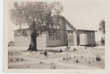
Photograph, Greenvale State School, 27 June 1934
The building is the former Greenvale State School No. 890. Although a school had been functioning at Greenvale since 1870. This is a photo of the school building that was renovated in 1926. At weekends the building was often used for family gatherings and social functions in the district. As the area became developed and changed from a country settlement to a suburb, the school was relocated to a new building closer to the new housing development. The existing building became a community centre. Many country settlements throughout Australia had similar school buildings which as well as being used for education also doubled up as venues for local social functioons.A non-digital sepia photograph with a surrounding white border of a two roomed country school with a water tank against a wall. A gum tree is growing in front of the building.schools -
 National Wool Museum
Throw, 2017
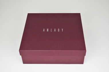
Anlaby’s sheep are born, bred and shorn at their farm located in South Australia. The wool is then scoured at Michels in Adelaide, combed and turned into Tops at Cashmere Connections in Bacchus Marsh, and then Spun and Woven at a historic mill in Scotland named Johnstons of Elgin. Sewing is completed by artisan seamstresses and packaging is from a local Adelaide family business. Established in 1839 just North of the Barossa Valley in South Australia, Anlaby is the oldest continuing merino sheep stud on mainland Australia. Fredrick Dutton employed Alexander Buchannan to bring sheep to the buoyant market in Adelaide from Goulburn NSW. Several others speculated on possible successes, including Buchannan and a flock of 18,000 sheep were walked overland. The trek took nine months. During this time the Adelaide market prices had collapsed. Having found land with a spring of sweet water, Dutton decided to keep his flock of 5,000 stud sheep and purchased a small parcel of land that is now called Anlaby. The property prospered and Buchannan was employed as manager for the next 25 years. At its height Anlaby covered 250sq miles – 160,000 acres and employed 70 men. The first bale of wool from South Australia to be auctioned in London came from Anlaby. The Anlaby stud also provided the foundation ewes for the well-known Bungaree merino stud in 1841. With prosperity came a large house and gardens for Buchannan in 1861. Anlaby was inherited by Henry Dutton from his uncle in 1895. Squire Dutton, as he was known, continued to grow the family’s fortunes and spent his money expanding the grand home and creating a magnificent 10-acre garden. Today the Anlaby merino stud continues and both the house and garden are undergoing significant restorations. Wool continues to be one of the most important elements at Anlaby. It was the source of great wealth in the past and is now directly tied into Anlaby’s future. Anlaby makes beautiful woollen scarves, lady’s wraps, exquisite throws and small range of baby blankets. From the moment a lamb is conceived and through its entire lifecycle Anlaby look after nutrition and quality of life. Twice a year the sheep are shorn and the wool using minimal treatment is washed, combed, spun and woven into the Anlaby product range. This attention to detail results in the buttery softness distinctive of the exclusive woollen range.Throw came with packaging and information card which reads ANLABY in large capital lettering at the top and bottom of either side of card. Throw is white with green edging of 15cm on two edges. Within this edging is the sewing of a tree in white.Wording: ANLABY Pure Anlaby Merino Wool Oldest merino stud on mainland Australia Made in Australia Card. Wording: ANLABY Certificate of Authentication THIS CERTIFICATE AUTHENTICATES THE PRODUCT TO BE 100% AUSTRALIAN AND MADE FROM PURE MERINO WOOL PRODUCED EXCLUSIVELY AT THE ANLABY MERINO STUD IN SOUTH AUSTRALIA THE ANLABY FLOCK (REGISTERED NUMBER 102) IS THE OLDEST CONTINUOSLY OPERATING MERINO STUD IN MAINLAND AUSTRALIA. THE MERINO FLOCK AT ANLABY MAINTAINS A GENETIC LINE STARTED IN 1839 THIS PRODUCT IS PART OF THE LIMMITED EDITION RANGE PRODUCED AT ANLABY. IN 2014 WE CELEBRATED ANLABY’S 175TH ANNIVERSAY ANLABY Reverse. Wording: ANLABY PURE NATURAL WOOL THE SHEEP GRAZE AMONGST THE GUM TREES ON THE ROLLING HILLS OF ANLABY. ANLABY SHEEP ARE CHARACTERISTICALLY BIG BODDIED AND BRED TO FLOURISH IN THE WARM AUSTRALIAN CLIMATE. OUR WOOL IS MINIMALLY TREATED AND THE PRODUCTS ARE MADE IN SMALL RUNS UNDER THE PERSONAL SUPERVISION OF THE OWNERS. WE BELIEVE IN SUSTAINABLE AND RESPONSIBLE FARMING AND MILLING PRACTICES. THE ATTENTION TO DETAIL RESULTS IN THE BUTTERY SOFTNESS DISTINCTIVE OF THIS EXCLUSIVE WOOLLEN PRODUCT. WITH CARE THIS IS A TREASURED ITEM FOR THE NEXT GENERATION. ANLABY www.anlaby.com.auwool, merino sheep, south australia, wool processing, wool processing textile finishing -
 Port Fairy Historical Society Museum and Archives
Functional object - Bath base, c. 1861
Hot water sea baths established in 1889 in Bank Street Port Fairy for separate men and women bathing. The bathes were closed in 1916. One bath was taken by Leo Brady when baths were demolished and used in his home until 1939. These items are from this bath.1. Metal bolt used to clamp slabs of marble for bath , from hot water baths. Bolt tapers from top to bottom and round knob on top. 2. Piece of white marble used in the sea baths - roughly triagular in shape. 3.Large piece of marble from the base of a sea bathlocal history, buildings, fittings -
 Port Fairy Historical Society Museum and Archives
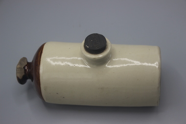
Domestic object - Hot Water Bottle
Not recorded but used as a bed warmerGlazed stoneware cylinder, knob handle and screw topHoffmanlocal history, ceramics, stoneware -
 Port Fairy Historical Society Museum and Archives
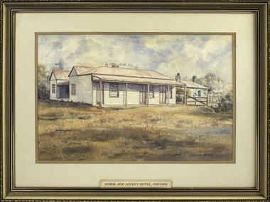
Painting - painting, watercolour, Horse and Jockey Hotel Orford, 01.02.1984
Painted for Mrs Ruby Young whose family owned the hotel at one time - (since burnt down) The hotel was built around 1857 near "Shaw Crossing" when Cowton and Bland selected the site because the bullockies watered and rested their stock on route Belfast and Portland. The name of the hotel came about because the winning post for the horse races was in front of the inn and the jockeys weighed in there.Illustration of a hotel that became the hub of social life in Orford that no longer exists.Watercolour painting of "Horse and Jockey" Hotel Orford. Frame composite wooden gilt embossingChristopher Mathews Ruby Young 1989 50 Whalers Road Victor Harbor S.A. 5211 1/2/84local history, illustrations, watercolours, horse and jockey hotel, ruby young, horseracing -
 Port Fairy Historical Society Museum and Archives
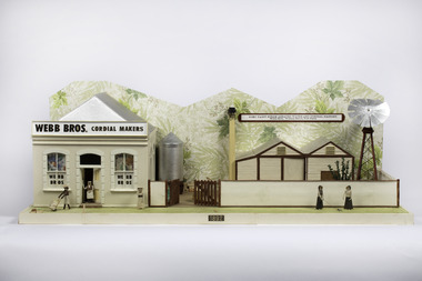
Mixed media - Model, Webbs Cordial Factory, Early 1970's
This model was part of a panorama 11 piece designs from an almanac in 1892 Port Fairy Gazette. The Panorama was used in a Historical Display in the historical society rooms in Bank Street This Panorama was part of an eleven piece Panorama of the Streetscape of Port Fairy in 1982. Made by a local resident.Large handmade model of a Factory front from the 1892 almanac.Webb Bros Cordial Makers Port Fairy Aerorated Water and Cordial Factory Webb Bros. William Street Port Fairypanorama, webb bros, model, almanac, a mewkill -
 Port Fairy Historical Society Museum and Archives
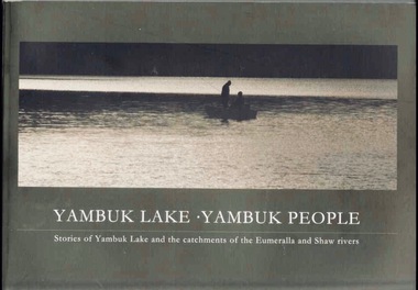
Book, Glenelg-Hopkins Catchment Management Authority, Yambuk Lake Yambuk people : stories of Yambuk Lake and the catchments of Eumeralla and Shaw Rivers, 2008
This title explores the complex relationships between the people and the place of Yambuk; the value of local knowledge and tells the stories of the Yambuk Lake, wetlands, rivers and catchment. Historic records and photographs are combined with the recollections of more than 20 people who know the lake.vi, 207 pages : colour illustrations, maps. ; 21 x 30 cm. Includes bibliographic references. non-fictionThis title explores the complex relationships between the people and the place of Yambuk; the value of local knowledge and tells the stories of the Yambuk Lake, wetlands, rivers and catchment. Historic records and photographs are combined with the recollections of more than 20 people who know the lake.baxter, annie maria, 1816-1905., water quality management -- victoria -- yambuk lake., settlement and contacts - settlers., animals - fish - eels., gunditjmara / gurndidy / dhaurwurd-wurrung people (s20) (vic sj54-11), yambuk (vic.) -- social conditions., yambuk (vic.) -- history., yambuk lake (vic.), yambuk (w vic sj54-11), deen maar / lady julia percy island (w vic sj54-11), eumeralla (w vic sj54-11), peek wurrung people, book -
 Melton City Libraries
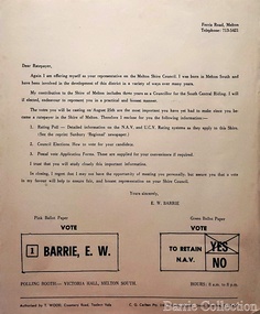
Letter, "Vote E.W Barrie" Local Council Election, Unknown
... Riding from 1969-1971, and member of the Water Trust Local ...Ernest W (Bon) Barrie was the Shire of Melton councillor South Riding from 1969-1971, and member of the Water TrustLetter to the ratepayers in the Melton Shire local identities, council -
 Parks Victoria - Wilsons Promontory Lightstation
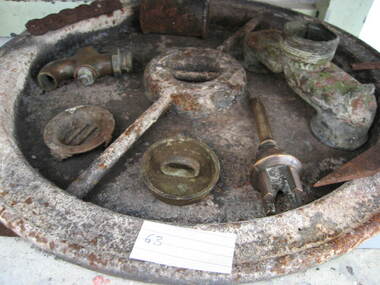
Tank lid
Lid for ship's tanks used for early domestic water storage (1860's) at the lightstation The water tank and lid are probably from the same unit that was used for transporting drinking water or perishable dry goods on ships. The unit comprised a large, riveted metal tank which was fitted with a heavy cast iron round lid to form a hermetically sealed container. It had a rubber sealing ring ‘which was screwed tight with the aid of lugs cast into the lid and wedges cast into the rim of the loading hole’. A raised iron rod welded across the outer face of many lids allowed for screwing the lid tight. Ship tanks were invented in1808 by notable engineer, Richard Trevithick and his associate John Dickinson. Their patent obtained the same year described the tank’s superior cubic shape that allowed it to fit squarely as a container in ships and thus use space efficiently, while its metal fabric preserved and secured its contents, whether liquid or solid, from damage. The containers revolutionised the movement of goods by ship and made wooden casks redundant. Research by Michael Pearson has determined that they were carried on passages to Australia from at least the 1830s, conveying ships’ victuals and water storage as well as general goods heading for the colonies, and by the 1870s they were in common use. Once in the colonies, the tanks were often recycled and adapted for many resourceful uses such as water tanks, packing cases, dog kennels, oil containers and food stores and this invariably led to the separation of the lid and tank. Raised lettering on the lids indicates that nearly all of the ship tanks transported to Australia came from London manufacturers, and it was usual also for the brand name to feature as a stencil on the associated square tank but in most cases this eventually wore off. It is not known if the Wilsons Promontory tank retains its stencil, and the heavy lid will need to be turned over to reveal its manufacturer’s name. How it came to the lightstation is also not known, but it was either brought to the site as a recycled tank or salvaged from a shipwreck. Pearson writes that Ship tanks show up at a wide range of sites, many of them isolated like lighthouses. They were, I think, usually taken there for the purposes they filled, usually water storage, as they were readily available, relatively light to transport, and probably very cheap to buy as second‐hand goods containers. In rural areas they may have been scavenged for their new uses from local stores, to whom goods were delivered in them. Recycled to serve as a water tank, the Wilsons Promontory tank is the last surviving example of several that were used at the site to hold water for domestic consumption. The tank has had its lid removed and a tap fitted to the one of the sides. It stands on concrete blocks next to a building to receive water running off the roof via a metal pipe. Wilsons Promontory is the only lightstation managed by Parks Victoria with a tank container, although Cape Otway and Point Hicks have lids. Parks Victoria has identified four other lids which include two at Point Hicks, one manufactured by Lancaster and Co. the other by Bellamy. Cape Otway also has two, one unidentified and the other by the Bow Tank Works, East London, which produced tanks between 1910 and 1930. Pearson notes that ‘surviving lids are far less numerous than the tanks themselves, presumably because the uses to which the tanks were put did not require the lid to be retained’. The tank and lid, which are possibly part of the same unit, have first level contributory significance for their historic values and rarity. Round ship's tanks lid, iron. -
 Bacchus Marsh & District Historical Society
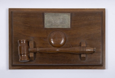
Ceremonial object, Presentation Gavel and Sound Block presented to Shire of Bacchus Marsh in Memory of Alec William Bond, 1968
Alec William Bond was Secretary and Engineer for the Shire of Bacchus Marsh from 1924 until his death in 1968. The position of Secretary was similar to a Chief Executive Officer in contemporary terminology. Mr Bond was a prominent figure in the Bacchus Marsh community for nearly 50 years and as Shire Engineer was responsible for the design of a number of local infrastructure projects including the buildings and water scheme at the Lady Northcote Children's Farm at Glenmore and the public swimming pool in Grant Street, A physical memento that recognises the long and notable contributions of an important local government official and their service to the Bacchus Marsh Shire and community.A sound block with a green felt base and inscribed brass plaque with accompanying small hardwood mallet in a cradle.Engraved text on a brass plaque which reads: Presented by May Bond and Family to the Shire of Bacchus Marsh in memory of Alec William Bond Shire Secretary & Engineer 1924 – 1968.alec william bond, bacchus marsh shire council, gavel and sound blocks, local officials and employees, local government -
 Bacchus Marsh & District Historical Society
Map, Lerderderg District Proposed Irrigation and Water Supply Trust (B) Plan Showing Proposed Works
The 1886 Irrigation Act in Victoria introduced the first legislation in Australia designed to enable the creation of a detailed scheme for agricultural irrigation. Part of the legislation saw the use of government funds for local irrigation projects. These local projects were managed by local irrigation trusts. The Lerderderg Irrigation and Water Supply Trust was formed in 1890. This map depicts the proposed area of the Trust and proposed works such as channels and weirs.Printed paper map of the proposed Lerderderg District Irrigation and Water Supply area showing proposed works. The map scale is 40 chains + 1 inch. The Lerderderg District lies within the Parishes of Korkuperrumul and Merrimu in the County of Bourke. At the top of the map above its title is the letter 'B; in capital lettering. A series of proposed channels are indicated on the map in red lines. A proposed weir site and alternative weir site are also indicated on the map. irrigation, water supply, lerderderg irrigation and water supply trust -
 Bacchus Marsh & District Historical Society
Map, Lerderderg District Proposed Irrigation and Water Supply Trust (C). Plan showing overlap in boundaries of the Trust District
The 1886 Irrigation Act in Victoria introduced the first legislation in Australia designed to enable the creation of a detailed scheme for agricultural irrigation. Part of the legislation saw the use of government funds for local irrigation projects. These local projects were managed by local irrigation trusts. The Lerderderg Irrigation and Water Supply Trust was formed in 1890. Printed paper map of the proposed Lerderderg District Irrigation and Water Supply. Plan showing overlap in boundaries of Trust District referred to in Mr Burke's report. The Lerderderg District lies within the Parishes of Korkuperrumul and Merrimu in the County of Bourke. At the top of the map above its title is the letter 'C; in capital lettering. A note on this map states: 'Portion of Bacchus MarshUrban District included in area of proposed Trust District shown by hatched shaded lines thus /////////////irrigation, water supply, lerderderg irrigation and water supply trust -
 Bacchus Marsh & District Historical Society
Map, Lerderderg District Proposed Irrigation and Water Supply Trust (A). Plan showing boundaries of Trust District
The 1886 Irrigation Act in Victoria introduced the first legislation in Australia designed to enable the creation of a detailed scheme for agricultural irrigation. Part of the legislation saw the use of government funds for local irrigation projects. These local projects were managed by local irrigation trusts. The Lerderderg Irrigation and Water Supply Trust] was formed in 1890. This map depicts the proposed area of the Trust.Printed paper map of the proposed Lerderderg District Irrigation and Water Supply. Plan showing boundaries of Trust District. The Lerderderg District lies within the Parishes of Korkuperrumul and Merrimu in the County of Bourke. At the top of the map above its title is the letter 'A; in capital lettering. Scale: 40 Chains = 1 inch.irrigation, water supply, lerderderg irrigation and water supply trust -
 Melton City Libraries
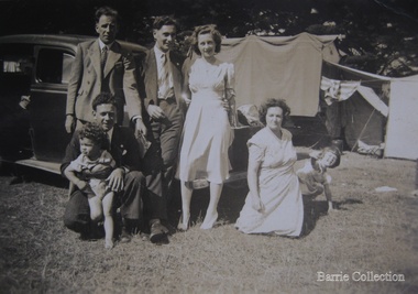
Photograph, Edna and Bon's family camp trip at Apollo Bay, 1948
Wendy Barrie's memories of Apollo Bay The camping trips were a yearly event after the harvest had finished. The trip down to the beach was a much-anticipated event heading out through Parwan and to Geelong leaving behind the hot and dusty plains and our parents relieved to have the hard work of harvesting left behind. The Otways in the distance were reached with great anticipation, Mum in the car and Dad in the Truck ahead of us anxiously winding through the narrow roads and negotiating the hairpin bends and breathing in the cool fresh air of the forest, and keeping an eye out of the log trucks that might come sweeping the corner. The tree ferns with their dripping moisture and the giant trees and the unmistakeable small of the eucalypts. Great excitement was when we caught our first view of the sea from the highest point of the road and then is was the cautious drive the sea level to the sight of the blue ocean with the white of the waves crashing on the rocks and the pristine sand. The water from the Wild Dog and Skenes creek trickling onto the ocean. The tree ferns with their dripping moisture and the giant trees and the unmistakeable smell of the eucalypts. The return journey was usually taken on the Great Ocean Road, it was considered safer to be on the inside of the road. In the early days it was very narrow and passing oncoming cars was taken very cautiously. Landslides and floods sometimes meant we would take the inland route. One year the bridges were washed away and bailey bridges were erected to keep the road open. Rock falls off the cliffs were common Stops on the way home gave us our last chance for our feet in the sand and a swim in the ocean. By the time we reached the hill at Angle Sea the vast blue ocean was behind us and we trekked back through Geelong- Bacchus road and the plains of stubble and the dry grass, and sometimes evidence of burnt patches from a bush fire. The closest we came to a pool at home was the concrete sheep trough at the gate to the work sheds. It was filled with bore water pumped from the nearby windmill. Edna, Bon and their family members at their camp site in Apollo Baylocal identities -
 Melton City Libraries
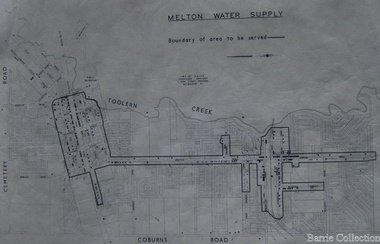
Map, Melton Water Supply, Unknown
The development that had arguably the greatest impact in encouraging population growth in the shire during this period, was the establishment of a reliable water supply for the district. This had been a major concern of the local community for over 100 years, since the Melton township was first founded. Despite various schemes over the years to create a reliable water supply, the district was still dependent on bores, wells and tanks when the Melton Waterworks Trust was established in 1961 to address Melton’s water woes. With the opening of the Djerriwarrh Dam in December 1963, the shire’s residents finally had access to a reticulated water supply.Map shows the boundary of the area where the water will be serviced in the towncouncil