Showing 518 items
matching map of mine
-
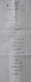
 Wangaratta RSL Sub Branch
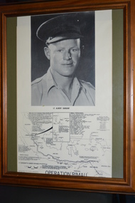
Mixed media - Framed copy of photograph and map, Lt. Albert Sargent
Lieutenant Albert Sargent VX15290 was born on the 3rd of November, 1918 at Wangaratta in Victoria. He was a member of Z Special Unit and involved in Operation RIMAU. when he was captured and executed by the Japanese in Malaya on the 7th of July, 1945 during WW2. Operation RIMAU - In September, 1944, 23 British and Australian members of Z Special Unit travelled from Australia by submarine to the outskirts of Singapore Harbour then under Japanese occupation. Their mission was to attack and destroy enemy shipping from small submersible boats using magnetic limpet mines. Official Japanese records state that the ten men of the contingent captured were beheaded at Pasir Panjang on 7 July 1945, approximately one month before World War II in the Pacific came to an end.Brown timber frame and green mount containing a copy of photograph of soldier and map showing RIMAU battles and listing RIMAU personnel.Lt Albert Sargent Operation RIMAUoperation rimau, albert sargent, z special unit, vx15290, wangaratta, ww2 -
 The Beechworth Burke Museum
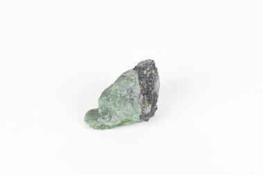
Geological specimen - Green Feldspar (orthoclase)
Feldspar, derived from the German word feldspat, is a group of minerals which is the most common mineral group found on Earth, making up more than half of the planet's crust. The major rock-forming minerals in the Feldspar group include albite, anorthite, orthoclase and microcline. (Mindat, Feldspar Group). Orthoclase is part of the Feldspar Group subgroup, Alkaline Feldspar, which are known to be poor in calcium, and mostly rich in potassium. It is further also considered to be a K Feldspar, a subgroup of Alkaline Feldspar that are Potassium-dominant with variable crystal symmetry and Al-Si ordering state. Orthoclase are most commonly Colorless to white, Greenish white, Grayish yellow, or Pale pink and transparent to translucent with slightly pearly cleavage. The mineral rates at a 6 on the Mohs Hardness Scale. (cannot be scratched with a knife, but scratches glass with difficulty). The stronger green colour of this particular specimen is distinctive to the Broken Hill region (where it was found), and due to a small amount of lead. (BB) Its qualities find it misidentified at times as as microcline variety amazonite. Broken Hill is one of the world’s richest lead-zinc-silver deposits. The huge, 300-million-tonne orebody was discovered in 1883 and the superb mineral specimens attract collectors from around the world. (Australian Museum, Minerals from Australia: Australian mining regions)While feldspar is not by any means rare, this particular specimen has qualities distinctive to the Broken Hill mining district, with these properties leading at times to the mineral's misidentification. This creates potential for further study and identification of these mineral deposits through methods such as microscopic twinning, or using the position of certain d values in XRD patterns to calculate the degree of disorder of a K-feldspar, as discussed on the Mindat website (Mindat.com, Orthoclase:About Orthoclase). This specimen is part of a larger collection of geological and mineral specimens collected from around Australia (and some parts of the world) and donated to the Burke Museum between 1868-1880. A large percentage of these specimens were collected in Victoria as part of the Geological Survey of Victoria that begun in 1852 (in response to the Gold Rush) to study and map the geology of Victoria. Collecting geological specimens was an important part of mapping and understanding the scientific makeup of the earth. Many of these specimens were sent to research and collecting organisations across Australia, including the Burke Museum, to educate and encourage further study.A solid small aluminosilicate mineral composition which is primarily pale green and blue-grey in colour with traces of beige and white throughout. Note: green plumbian orthoclase (aka green feldspar) is an indicator mineral for the Broken Hill style lead-zinc deposits.N/Abroken hill mine, geological specimen, minerology -
 The Beechworth Burke Museum
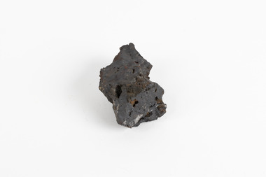
Geological specimen - Hematite (iron oxide)
Hematite is an iron ore significant for its high iron content (70%) and as being one of the two main iron oxide minerals, the other being magnetite. Hematite has a rating of 5-6 on the Moh's hardness scale and is often found as an accessory mineral in many igneous rocks. (an accessory mineral being "any mineral in an igneous rock not essential to the naming of the rock" - Britannica) Hematite has historically been the mainstay of South Australia’s iron ore production. (Magnetite: South Australia’s potential) Making up the eastern section of the Gawler Rangers, the Middleback Range is a mountain range on the eastern side of Eyre Peninsula in South Australia that has been a source of iron ore (its main commodity in minerals) for over a century. (see https://www.mindat.org/loc-22576.html). "Large reserves of high-grade iron ore were identified in 1890 in the Middleback Range, west of Whyalla. From 1915 these ores were shipped to Newcastle and later to Port Kembla, both in New South Wales. Local production of pig iron began when the first blast furnace was opened at Whyalla in 1941, and construction of an integrated iron and steel plant began there in 1958." (Britannica, South Australia: Resources and power). This area is home to 24 mines/mineral deposits (according to mindat.org, thought the Sarig Map provided by SA gov on their Energy and Mining website indicates significantly more mining leases).This mineral specimen was collected from the Middleback Ranges before the area was identified as holding large reserves of iron ore and being commercially mined and is representative of South Australia's significant and ongoing history of iron ore mining, and its contribution to Australia's steel manufacturing industry of the early 20th century (this specimen being collected in the prelude to these events).A small ferric oxide mineral composition a mid-blue-grey in colour with specks of rust-brown throughout.HEMATITE / (iron oxide) / Locality: Middleback Ranges, S. Aust.middleback ranges, iron ore mining, mining, south australia -
 Bendigo Historical Society Inc.
Map - HUSTLER'S REEF NO 1 MINE - TRANSVERSE SECTION OF THE HUSTLER'S REEF NO 1 MINE
... MINING Parish Map Hustler's Reef No 1 Mine Hustler's Line ...Map of a transverse Section of the Hustler's Reef No 1 Mine on the hustler's Line of Reefs Bulletin No 33, Plate No XXI. Map shows poppet legs at 801.07 feet above Sea Level and drawing of shaft with the different levels. Also shown are geological features and stone encountered. Geological Survey of Victoria emblem H Herman, Director, W Dickson, Secretary of Mines and The Hon. J. Drysdale Brown MLC Minister of Mines. Signed by H S Whitelaw, Underground Survey Office Bendigo, September 1913. This item has not been scanned or photographed.mining, parish map, hustler's reef no 1 mine, hustler's line of reefs, geological survey of victoria, underground survey office bendigo, h s whitelaw, h herman, w dickson, the hon j drysdale brown -
 Bendigo Historical Society Inc.
Map - HUSTLER'S ROYAL RESERVE NO 2 CO. - LONGITUDINAL SECTION OF THE HUSTLER'S ROYAL RESERVE NO 2 CO
Longitudinal Section of the Hustler's Royal Reserve No 2 Co. on the Hustler's Line of Reef Bulletin No 33, Plate No VIII. Note - Plates 4, 8, 13, 20, 26 & 31 form a Longitudinal Section from Fortuna Hustler's to Hustler's Consols Mine. Mines mentioned are the Hustler's Royal Reserve No 2 Main Shaft, Hustler's Royal Reserve No 2 Park Shaft, Royal Hustler's, Imperial Hustler's, Great Extended Hustler's Freehold and the Great Extended. Section shows depth of levels, datum lines and height of sill above sea level yield in oz. of gold. Geological Survey of Victoria emblem. H. Herman, Director, W. Dickson, Secretary for Mines and The Hon. J. Drysdale Brown MLC, Minister for Mines and signed by H S Whitelaw, Underground Survey Office Bendigo, September 1913. mining, parish map, hustler's royal reserve no 2, royal hustler's, imperial hustler's, great extended hustler's freehold, great extended, geological survey of victoria, underground survey office bendigo, h s whitelaw, h herman, w dickson, the hon j drysdale brown -
 Bendigo Historical Society Inc.
Map - HUSTLER'S ROYAL RESERVE NO 2 MINE - PLAN OF THE HUSTLER'S ROYAL RESERVE NO 2 MINE
Plan of the Hustler's Royal Reserve No 2 Mine Bulletin No 33, Plate No V. Plan shows the Hustler's Royal Reserve No 2 (Main Shaft), Hustler's Royal Reserve No 2 (Park Shaft.), the Royal Hustler's, the Imperial Hustler's and the Extended Hustler's Freehold on the Hustler's Line of Reefs. Also mentioned is the Lightning Hill Line of Reefs. Map shows some of the levels, approximate boundary of lease and the boundary of Lease No 8892 and 8897. There are also street names and the locations of jail, lagoons, Post Office, Rosalind Park and the State School, High School and Continuation School. Geological Survey of Victoria emblem. H. Herman Director, W. Dickson, Secretary of Mines and The Hon. J. Drysdale Brown MLC, Minister of Mines. Signed by zh Whitdan, Underground Survey Office, Bendigo, September 1913.mining, parish map, hustler's royal reserve no 2 mine, royal hustler's, imperial hustler's, extended hustler's freehold, geological survey of victoria, h herman, w dickson, the hon j drysdale brown, h whitdan, hustler's line of reefs, lightning hill line of reefs -
 Bendigo Historical Society Inc.
Map - HUSTLER'S ROYAL RESERVE NO 2 MINE - PLAN OF THE HUSTLER'S ROYAL RESERVE NO 2 MINE
Plan of the Hustler's Royal Reserve No 2 Mine on the Hustler's Line of Reefs Bulletin No 33, Plate No VI. Boundary of Leases No 8898 and 8897 shown. Various levels shown and some geographical features. Geological Survey of Victoria emblem. H . Harman, Director, W. Dickson, Secretary for Mines and The Hon. J. Drysdale Brown, Minister of Mines and signed by H Whitdon, Underground Survey Office, Bendigo, September 1913. mining, parish map, hustler's royal reserve no 2 mine, hustler's line of reefs, geological survey of victoria, h herman, w dickson, the hon j drysdale brown mlc -
 Bendigo Historical Society Inc.
Map - HUSTLER'S ROYAL RESERVE NO 2 CO - TRANSVERSE SECTION OF THE HUSTLER'S ROYAL RESERVE NO 2 CO
Transverse Section of the Hustler's Royal Reserve No 2 Co Mine on the Hustler's Line of Reef Bendigo, Bulletin No 33, Plate No VII. Section shows the poppet legs and the sill of Shaft at 707.65 ft above sea level, depth of levels, stone encountered and geological features. Geological Survey of Victoria emblem. H. Herman Director, W. Dickson Secretary of Mines and The Hon. J. Drysdale Brown MLC, Minister of Mines. Signed by H S Whitelaw, Underground Survey Office Bendigo, September 1913. mining, parish map, hustler's royal reserve no 2 co, h s whitelaw, undergrou;nd survey office bendigo, geological survey of victoria, h herman, w dickson, the hon. j drysdale brown mlc -
 Bendigo Historical Society Inc.
Map - HUSTLER'S ROYAL RESERVE NO 2 (PARK SHAFT.) - TRANSVERSE SECTION OF THE HUSTLER'S ROYAL RESERVE NO 2
Transverse section of the Hustler's Royal Reserve, No 2 (Park Shaft.) on the Hustler's Line of Reef. Bulletin No 33, Plate No IX. Section shows poppet legs and sill of shaft at 755.70 ft above sea level, depth of levels, type of stone encountered including lava and geological features. Geological Survey of Victoria emblem and beneath it H. Herman, Director, W. Dickson, Secretary of Mines and The Hon. J. Drysdale Brown MLC Minister of Mines and signed by H S Whitelaw, Underground Survey Office, Bendigo September 1913.mining, parish map, hustler's royal reserve no 2 (park shaft.), h s whitelaw, underground survey office bendigo, geological survey of victoria, h herman, w dickson, the hon j drysdale brown mlc, hustler's line of reef -
 Bendigo Historical Society Inc.
Map - UNITED HUSTLER'S & REDAN & K. K. MINES - PLAN OF THE UNITED HUSTLER'S & REDAN & K. K. MINES
Plan of the United Hustler's & Redan & K. K. Mines Bulletin No 33 Plate No XXXI. Shows depth of levels, Probable positions of reefs and natural surface with the poppet legs at the two shafts. Sill of shaft of the K. K. Mine 773.56 ft above Sea Level and sill of shaft of the United Hustler's & Redan Mine 745.62 above Sea Level. Also mentioned is the average amount of gold obtained per ton. Note on the top of page - Plates 4, 8, 13, 20, 26 & 31 form a Longitudinal Section from Fortuna Hustler's to Hustler's Consols Mine. Geological Survey of Victoria emblem and signed by H S Whitelaw, Underground Survey Office, Bendigo, September 1913. mining, parish map, united hustler's & redan & k. k. mines, geological survey of victoria, h s whitelaw, underground survey office bendigo -
 Bendigo Historical Society Inc.
Map - UNITED HUSTLER'S & REDAN & K. K. MINES - PLAN OF UNITED HUSTLER'S & REDAN & K. K. MINES
Plan of the United Hustler's & Redan & K. K. Mines on the Hustler's Line of Reefs Bulletin No 33 Plate No XXVII. Plan shows depth of levels, Long Gully, Hustler's Line of Reefs, Lightning Hill Line of Reefs and approximate Boundary of Lease. Also mentions Comet Co. Geological Survey of Victoria emblem and signed by H S Whitelaw, Underground Survey Office Bendigo September 1913.mining, parish map, united hustler's & redan & k. k. mines, long gully, hustler's line of reefs, lightning hill line of reefs, comet co, h s whitelaw, geological survey of victoria, underground survey office -
 Bendigo Historical Society Inc.
Map - UNITED HUSTLER'S & REDAN & K. K. MINES - PLAN OF UNITED HUSTLER'S & REDAN & K. K. MINES
Plan of the United Hustler's & Redan & K. K. Mines on the Hustler's Line of Reefs Bulletin No 33 Plate No XXVIII. Plan shows depth of levels, stone encountered and some geological features. Geological Survey of Victoria emblem and signed by H S Whitelaw, Underground Survey Office Bendigo, September 1913. mining, parish map, united hustler's & redan & k. k. mines, united hustler's and redan shaft, k. k. shaft, h s whitelaw -
 Bendigo Historical Society Inc.
Map - UNITED HUSTLER'S & REDAN MINE - TRANSVERSE SECTION UNITED HUSTLER'S & REDAN MINE
... MINING Parish Map United Hustler's & Redan Mine Hustler's ...Transverse Section of the United Hustler's & Redan Mine on the Hustler's Line of Reefs Bulletin No 33, Plate No XXIX. Map has drawing of poppet legs on the surface, depth of levels, type of stone encountered and some geological features. Sill of shaft 745.62 ft above sea level. Map has Geological Survey of Victoria emblem and signed by H S Whitelaw, Underground Survey Office Bendigo, 'September 1913. mining, parish map, united hustler's & redan mine, hustler's line of reef, geological survey of victoria, h s whitelaw -
 Bendigo Historical Society Inc.
Map - UNITED HUSTLER'S & REDAN MINE - TRANSVERSE SECTIONS N & S OF SHAFT UNITED HUSTLER'S & REDAN MINE
... MINING Parish Map United Hustler's & Redan Mine Transverse ...Transverse Sections N & S of Shaft United Hustler's & Redan Mine on the Hustler's Line of Reef Bulletin No 33, Plate No XXX. Map shows some of the stone encountered on the levels and depth. Geological Survey of Victoria emblem and signed by H A Whitdan, Underground Survey Office Bendigo, September 1913.mining, parish map, united hustler's & redan mine, transverse sections n & s of shaft united hustler's & redan mine, hustler's line of reef -
 Bendigo Historical Society Inc.
Map - K. K. MINE - TRANSVERSE SECTION K. K. MINE
... Office Bendigo, September 1913. Map K. K. MINE - TRANSVERSE ...Transverse Section of the K. K. Mine on the Hustler's Line of Reefs, Bulletin No 33, Plate No XXXII. Map shows the different levels and their depth. Also, the different types of stone encountered and geological features such as spurs and faults. Has drawing of the poppet legs at the top of the shaft and sill of shaft 773.56 ft above sea level. Map has Geological Survey of Victoria crest and signed by H S Whitelaw, Underground Survey Office Bendigo, September 1913. miners, fortuna hustler's mine, transverse section of k. k. mine, hustler's line of reefs, geological survey of victoria, h s whitelaw -
 Victorian Railway History Library
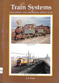
Book, Vines, J.A, 1994
... colliery between the Yallourn and Morwell open cut brown coal mines ...A history of the narrow gauge colliery between the Yallourn and Morwell open cut brown coal mines in Gippsland Victoria.ill, maps, p.248.non-fictionA history of the narrow gauge colliery between the Yallourn and Morwell open cut brown coal mines in Gippsland Victoria.colliery railroads - victoria - history, narrow gauge railroads - australia - history -
 Bendigo Historical Society Inc.
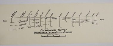
Map - SHEEPSHEAD LINE OF REEF, Circa 1940's
... MAP Bendigo mining plan Sheepshead line of Reef Gold mines ...Map: Plan showing a Longitudinal section of the Sheepshead line of Reefs , Bendigo. (34 Copies)map, bendigo, mining plan, sheepshead line of reef, gold mines , mining -
 Bendigo Historical Society Inc.
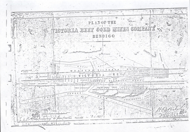
Document - VICTORIA HILL - PLAN OF THE VICTORIA REEF GOLD MINES COMPANY BENDIGO
3587.70 same as 3587.69. Copied onto smaller white paper.map, bendigo, victoria hill, plan of the victoria reef gold mines company bendigo -
 Bendigo Historical Society Inc.
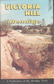
Book - VICTORIA HILL - VICTORIA HILL BENDIGO
... beds of Lansell's '180' mine. There are also two maps, History... of the Central Nell Gwynne Mine, Victoria Hill in the 1860's, with Rae's ...Booklet titled: 'Victoria Hill Bendigo A Publication of the Bendigo Trust'. Booklet has photos of the Central Nell Gwynne Mine, Victoria Hill in the 1860's, with Rae's Battery in the foreground, geographical features, Rae's Open Cut, Victoria Hill from the New Chum Hill in the 1870's, compressor beds, The Victoria Quartz Mine, burnt ground from quartz roasting, the remains of a twenty head crushing battery, a view from Ballerstedt's Open Cut showing the historic Gold Mines Hotel built in 1857 and the engine beds of Lansell's '180' mine. There are also two maps, History of Victoria Hill and geographical notes on the area.book, bendigo, victoria hill -
 Bendigo Historical Society Inc.
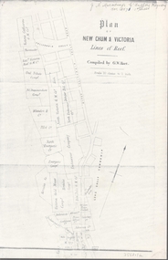
Map - NEW CHUM & VICTORIA LINES OF REEF - PLAN OF NEW CHUM & VICTORIA LINES OF REEF
Two pages of a Plan of New Chum & Victoria Lines of Reef, compiled by G. W. Hart. Taken from J. N. Macartney's G'Fields Registry for 1871. Plan shows leases from High Street to California Gully. Location of the Manchester Arms, British & American Hotel and the Quartz Miners Arms are shown. Townships of Long Gully and Ironbark are shown.map, goldfields, new chum & victoria lines of reef, victoria catharine g m coy, thornton & co, extd victoria reef g m co, ural tribute compy, nil desperandum compy, koch, north victoria g m co, danger hill coy, north endeavour coy, wheadon & co, pilot co, north energetic co, energetic compy, endeavour company, hercules co, victoria gold mines compy, iron duke g m co, golden fleece united, ballerstedt, alfred co, confidence co, prince alfred co, canterbury co, advance co, wells, humboldt co, adventure co, try me well, sterry & co, gibbs & ballerstedt, handy andy, wells?, south adventure co, w rae, victoria reef quartz m co, myra co, jackson, wybrants, burrows & sterry, new chum & victoria tribute, old chum co, ballerstedt, lazarus, watson, koch & hildebrand, lansell & hunt, dennis, abe lincoln co, bonati & co, ellesmere co, moore late menzies, british co, british tribute co, garibaldi, c c co, new chum trib, dobson & co, young chum co, little chum co, old chum co, new chum trib, little chum trib, g w hart, j n macartney's g'fields registry for 1871, manchester arms, british & american, quartz miners arms -
 Bendigo Historical Society Inc.
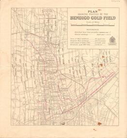
Map - GOLDFIELD MAP
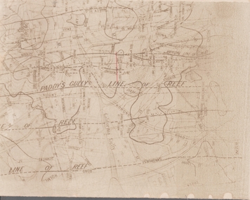
... of Reef North Johnson Shaft Mine Shafts Portion of the map ...Portion of the map of the Bendigo Goldfield with the Paddy's Gully Line of Reef near the centre. Streets, contours and gullies are included. Underlined in red is the North Johnson Shaft.map, bendigo, goldfields, goldfield map, paddy's gully line of reef, north johnson shaft, mine shafts -
 Bendigo Historical Society Inc.
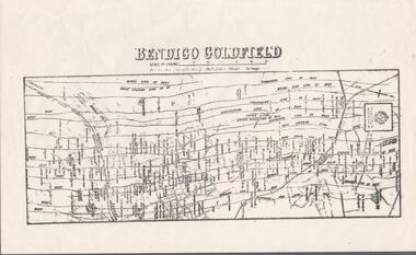
Map - BENDIGO GOLDFIELD MAP
... . of Mines, Victoria printed on the map. Shows reefs from Bird's... and mines are shown. Dept. of Mines, Victoria printed on the map ...Two not very clear copies of the Bendigo Goldfield Map. Streets, Railway Line, Lines of Reefs and mines are shown. Dept. of Mines, Victoria printed on the map. Shows reefs from Bird's Line of Reefs to Lightning Hill Line of Reef.map, bendigo, goldfields, bendigo goldfield map, lines of reefs, dept. of mines victoria -
 Bendigo Historical Society Inc.
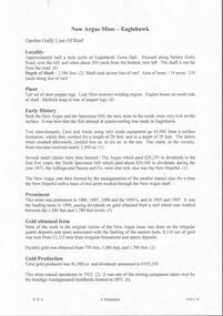
Document - NEW ARGUS MINE - NOTES ON THE NEW ARGUS MINE
One handwritten and four typed copies of notes on the New Argus Mine at Eaglehawk. One typed copy has a locality map attached. Notes mention locality, depth of shaft, early history, prominence, amount of gold obtained and production. References; Special Edition Australian Mining Standard 1/6/1899, Mines Dept. Booklet 'Bendigo Goldfield' 1936, Mines Department Annual and Special Reports, Annals of Bendigo Mining Section 1886 - 1922 and A. Richardson. 4 Typewritten copies of this item have not been scanned.document, gold, new argus mine, new argus mine, notes on the new argus mine, eaglehawk, specimen hill mine, mr cave, mr amos, the argus mine, north specimen hill mine, adlinga and pascoe & co, new hopeful, bendigo amalgamated goldfields, special edition australian mining standard 1/6/1899, mines dept. booklet 'bendigo goldfield 1936, mines dept. annual and special reports, annals of bendigo mining section 1886 - 1922, a richardson -
 Bendigo Historical Society Inc.
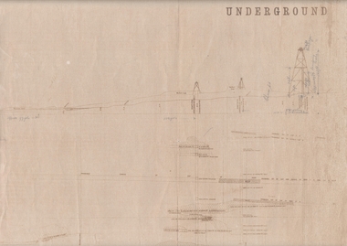
Map - UNDERGROUND SECTION OF 3 MINES
... in. Map UNDERGROUND SECTION OF 3 MINES ...Underground section of three mines - Shaft No 94, New Chum United Co, Cross Section No 89 - Shaft No 93, Lansell's 222 (DENIS), Cross Section No 87 - Shaft No 92A (New Shaft), Lansell's 222, Cross Section No 86. Map shows depth of cross sections below the sill and stone encountered. Poppet legs are drawn at the top of the shafts. Lansell's 222 Shaft No 92A has measurements penciled in.mining, parish map, new chum united, lansell's 222 -
 Bendigo Historical Society Inc.
Document - LADY BARKLY MINE - NOTES ON THE LADY BARKLY MINE
One hand written and four typed copies of notes on the Lady Barkly Mine on the New Chum Line of Reef. Hand written copy has a small hand drawn locality map and a reference list attached. Notes include localilty, depth of shaft, size of lease, Plant. Battery was shared by The South St Mungo Mine, Early History, Prominence, Production and Reference. First year of production 1864 and last year of production 1907. One typed copy signed by A Richardson 29 Harrison St Bendigo. 4 typewritten copies not scanned.document, gold, lady barkly mine, lady barkly mine, st mungo group, snobs' hill, sadowa shaft, st mungo shaft, lady barkly, special edition aust. mining standard 1/6/99, mines dept booklet 'bendigo goldfield 1936, mines dept annual and quarterly reports, annalso fbendigo mining section 1880 - 1908, a richardson, kilfoy and co, robbins & co, ringale and north devonshire cos -
 Bendigo Historical Society Inc.
Map - BENDIGO GOLD FIELD - MAP OF PORTION OF THE BENDIGO GOLD FIELD
... of Reefs Gullies Mines Map showing portion of the Bendigo Gold ...Map showing portion of the Bendigo Gold Field showing Alluvial working, shaft sites , streets and lines of reefs.Department of Mines, Victoria. Many mines, lines of reefs and gullies are on the map. Blue Royal Historical Society of Victoria Bendigo Branch stamp on the back.document, bendigo gold field, department of mines, lines of reefs, gullies, mines -
 Bendigo Historical Society Inc.
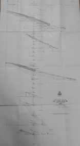
Map - GREAT EXTENDED HUSTLER'S MINE - LONGITUDINAL SECTION OF THE GREAT EXTENDED HUSTLER'S MINE
... MINING Parish Map Great Extended Hustler's Mine Geological ...Longitudinal Section of the Great Extended Hustler's Mine on the Hustler's Line of Reefs. Bulletin No 33, Plate No XIII. Map shows the Hustler's Tribute, 2 Old Shafts, Great Extended Hustler's Shaft, Latham & Watson's Shaft and Ironbark Gully. Datum Line 750 feet above Sea Level. Poppet Legs on the surface and Sill of Shaft 788.99 feet above Sea Level. Levels and their depths are shown and some geographical features. Some amounts of gold mined mentioned. Geological Survey of Victoria emblem and signed by H A Whitelaw, Underground Survey Office Bendigo, September 1913. Note - Plates 4, 8, 13,20, 26 & 31 form a Longitudinal Section from Fortuna Hustlers to Hustler's Consols Mine. mining, parish map, great extended hustler's mine, geological survey of victoria, underground survey office bendigo, h a whitelaw, hustler's tribute, old shaft, great extended hustler's shaft, latham & watson's shaft, ironbark gully -
 Bendigo Historical Society Inc.
Map - GREAT EXTENDED HUSTLER'S MINE - TRANSVERSE SECTION OF THE GREAT EXTENDED HUSTLER'S MINE
... MINING Parish Map Great Extended Hustler's Mine Transverse ...Transverse Section of the Great Extended Hustler's Mine on the Hustler's Line of Reef. Bulletin No 33, Plate No XII. Shows Poppet legs at the surface and Sill of Shaft at 788.99 feet above Sea Level, Cross Cuts and their depths, stone and geographical features encountered and their references and a number of enlarged drawing of sections of the crosscuts, Geological Survey of Victoria emblem and signed by H A Whitelaw, Underground Survey Office Bendigo, September 1913. The depths of crosscuts to No 21 were taken from plans of surveys by Mr. Walker and Mr. Craven, noted under Reference. Another note: This Saddle Reef is sketched from Mr. Walker's plan. Dividends amounting to 360,000 pounds were obtained from it. mining, parish map, great extended hustler's mine, transverse section of the great extended hustler's mine, old shaft, mr walker, mr craven, geological survey of victoria, underground survey office bendigo, h a whitelaw -
 Bendigo Historical Society Inc.
Map - GREAT EXTENDED HUSTLER'S MINE - PLAN OF THE GREAT EXTENDED HUSTLER'S MINE
... MINING Parish Map Great Extended Hustler's Mine No 2 Shaft ...Plan of the Great Extended Hustler's Mine. Bulletin No 33, Plate No XI. Shows No 2 Shaft, Latham & Watson's Shaft, levels and their depths and some geographical features. Geographical Survey of Victoria emblem and signed by H A Whitelaw, Underground Survey Office, Bendigo, September 1913. Has reference to photos.mining, parish map, great extended hustler's mine, no 2 shaft, latham & watson's shaft, geological survey of victoria, underground survey office bendigo, h a whitelaw -
 Bendigo Historical Society Inc.
Map - FORTUNA HUSTLER'S MINE - TRANSVERSE SECTION OF THE FORTUNA HUSTLER'S MINE
... MINING Fortuna Hustler's Mine Hustler's Line of Reef ...Transverse Section of the Fortuna Hustler's Mine on the Hustler's Line of Reef, Bendigo. Bulletin No 33, Plate No III. Drawing shows poppet legs on the surface and Sill of Shaft 745.38 feet above Sea Level. Shows levels and their depths, geographical features and stone encountered. Reference table to stone and geographical features. Geographical Survey of Victoria emblem. Signed by H A Whitelaw, Underground Survey Office, Bendigo. mining, fortuna hustler's mine, hustler's line of reef, geological survey of victoria, underground survey office bendigo, h a whitelaw