Showing 3152 items matching "miles"
-
 Bendigo Historical Society Inc.
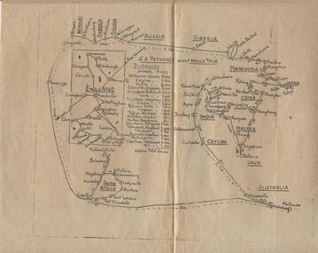
Document - PETHARD COLLECTION: SKETCH MAP - G. A. PETHARD'S SECOND WORLD TOUR
Sketch Map - G. A. Pethard's second World Tour showing route and intermediate mileages and total mileage (60,00 miles). Route details for tour via india, Malaya, China, Japan, Siberia, Scandanavia, England, Soth Africa.person, individual, mayor of bendigo -
 Robin Boyd Foundation
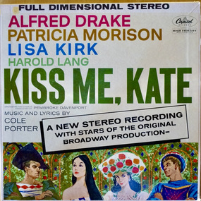
Audio - Recording, Capitol Records
The Boyds purchased their record player and sound system from Thomas’s in Melbourne. Patricia Boyd (later Davies) was very interested in opera and was later appointed to the Board of the Australian Opera.Kiss Me, Kate. LP 33RPM vinyl, Catalogue Number: STAO 1267, Double layout cover 1 vinyl disc, inside cover notes by Miles Kreuger. Cole Porter, Orchestra and chorus conducted by Pembroke Davenport.lp, sound recording -
 Ballarat Tramway Museum
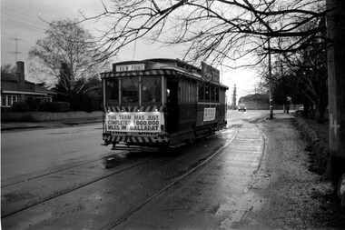
Photograph - Tram 27 Million Miles - Mal Rowe - 29/6/1968
Photo taken as part of the TMSV tour of the tramway system on a typical Ballarat winters day. Photo in the then disconnected View Point loop in Wendouree Parade. The fence of Ballarat A Power station can be seen in the background. Yields information about the purported achievement of tram 27 reaching 1,000,000 miles and the TMSV Tour. Shows the former View Point crossing loop. This figure was later found to be in error by about 100,000 miles.Digital image of a photograph by Mal Rowe of tram 27 at the former View Point Loop in Wendouree Parade 29/6/1968, during the Tramway Museum Society of Victoria tour to celebrate the tram doing 1,000,000 miles in Ballarat. tmsv, wendouree parade, view point, million miles, tram 27 -
 Tarnagulla History Archive
Draft for Telegram, 4th March 1862
A large lot of papers, including this and many other telegrams, were apparently found in the ceiling cavity of the Sandy Creek/Tarnagulla Post and Telegraph Office in the later 20th Century, during building works. Donald Clark Collection. Handwritten draft for a telegram sent from Tarnagulla Telegraph Office from Henry Pouris to Thomas Miles Esq, 26 Regent St, Fitzroy. Text reads 'Voucher forwarded. Starting for Red Bank tomorrow. Alls well'. -
 Bendigo Military Museum
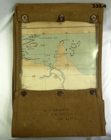
Accessory - MAP CASE & MAPS, C.1939 -45
John James Davies No VX35280 enlisted in the 2nd AIF on 1.8.40 age 31 years. At discharge on 30.11.45 he held the rank of WO 2nd class in 2/108th Aust Light Anti Aircraft detachment..1) Map case, canvas khaki. .2) Map of Darwin, NT. Scale 4 miles to 1 inch. .3) Map, folded, New Guinea made by Hec Robinson Sydney .4) Map Pine Creek N.T.zippered section marked "J. J. Davies VX35280 108 LAD”maps, canvas case, military -
 The Beechworth Burke Museum
Photograph, c.1927-1930
This image shows the Punt (a kind of small boat) that took residents of Bethanga across the Murray River before the Bethanga Bridge was built. Bethanga Bridge was built between 1927 and 1930, and was made a necessity by the building of the Hume Dam. The Hume Dam, formerly known as the Hume Weir, was in construction between 1919 and 1936, which swelled the Murray River into the floodplain to the East of the dam permanently, creating Lake Hume, and isolating the residents of Bethanga and nearby towns, for whom the trip all the way around the new lake to another river crossing was a massive undertaking. The person who wrote on the back of this card instead chose to cross the river on a boat until the Bethanga Bridge became available. Interestingly, partially submerged trees can be seen in the lake in the background of this photograph, illustrating that the dam had already begun to fill the floodplain even before the bridge was built. This photograph shows the methods the residents of Bethanga used while the Bethanga Bridge was being built. This record is associated with the Heritage Listed sites of the Hume Dam and the Bethanga Bridge, and shows the environment during the process of construction and the creation of Lake HumeSepia rectangular photograph printed on matte photographic paperReverse: 1997.3189 / 84 -19 -1 / This is the snap of the Punt. / Our only means of getting out / of Bethanga for the present / Until the bridge is completed / it is 2 miles above the junction / of the Mitta + Murray. It is / 1/2 a mile wide + runs across / the Murray into NSW / Kodak Print / bethanga, bethanga bridge, hume, hume dam, artificial lake, lake hume, hume weir, flood, floodplain, boat, punt, weir, pier, dock, transport, transportation -
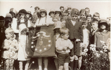 Mt Dandenong & District Historical Society Inc.
Photograph, St Matthew's Sunday School, Olinda. c1935, c1935
Young students from St Matthew's Sunday School, Olinda holding the Sunday School Shield. C 1935. The pictured shield is kept in the St Matthew's Church Hall. From the back L - R. ?, Jean Patterson, Peggy Hall, Roy Breen, Mona Griffin, ?, Gwen Evans, Douglas Hall, Bill Brown, Keith Evans, Stewart Brown, Jack Breen, Ian Ellis, ?, ?, ?, Jeff Evans, Russell Hall, ?, ?, John Miles, Frank Boulter, Joan Boulter, Geoff Miles, Joan Bartlett, Nan Breen, Thomas Hall.school, sunday school, st matthew's church, children, school children, jean patterson, peggy hall, roy breen, mona griffin, gwen evans, douglas hall, bill brown, keith evans, stewart brown, jack breen, ian ellis, jeff evans, russell hall, john miles, frank boulter, joan boulter, geoff miles, joan bartlett, nan breen, thomas hall -
 Ballan Shire Historical Society
Map - Map. Shire of Ballan, Shire of Ballan
This is a fairly comprehensive map of the former Shire of Ballan which is now amalgamated into the Shire of Moorabool.A black and white map of the Shire of Ballan showing major roads, rivers, towns, settlements, State parks and forests and land subdivisions. It appears to be a copy of the original as no dates or maker or printer appear on the map. There is a scale of 2 miles to 1 inch.gordon, ballan, bungal, kerrit bareet, borhoneyghurk, bungeeltap, ballark, yaloak, gorong, beremboke, wallace, ingliston, hunterston, millbrook, bradshaw, myrniong, blackwood, moorarbool, greendale, bayup, trentham, bullarto, korweinguboora, glenlyon, bolwarra -
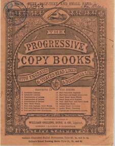 Bendigo Historical Society Inc.
Book - PROGRESSIVE COPY BOOK (AGNES MILES), 1890s
Progressive Copy Book with orange cover (name of Agnes Miles handwritten in ink on front cover) All exercises completed in ink. Printed by William Collins, Sons & Co. London, Glasgow and Edinburgh. Various RHSV stamps and date markings.school, history, handwriting, agnes miles. -
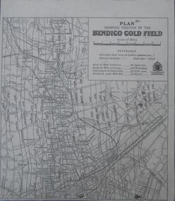 Bendigo Historical Society Inc.
Map - Bendigo Gold Field
Plan showing portion of the Bendigo goldfield. Area of main goldfield: 140 square miles. Deepest mine working: 4593' (Victoria quartz). Gold output of field to 1935: 20,775,000 ounces. Dividends paid 1870-1935: 10,740,000 pounds.map, goldfield, bendigo -
Tarnagulla History Archive
Telegram, March 1862
A large lot of papers, including this and many other telegrams, were apparently found in the ceiling cavity of the Sandy Creek/Tarnagulla Post and Telegraph Office in the later 20th Century, during building works. Donald Clark Collection. Telegram sent from Tarnagulla Telegraph Office from Henry Pouris to Thomas Miles Esq, 26 Regent St, Fitzroy. Text reads 'Everything satisfactory. Telegram from McLean ____. Letter to be forwarded pay sheet for here sent'. -
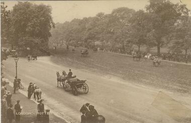 Bendigo Historical Society Inc.
Postcard - BLANCHE SLY POSTCARD COLLECTION, 1900 - 1920
Postcard Album of Blanche Sly. Postcards stored in Folder 81 (49 postcards). 1403.1 - 1403.28 Grey linen look cover with picture of a small sailing boat pasted centre front pf cover. Partly torn sticker on lower LH corner. Blanche Victoria SLY Born: 11 Oct 1890, daughter of William and Hannah Sly Address: 1913; Loddon Vale Address: 1980; 100 Barnard Street Bendigo Died: Bendigo 12 June 1982, buried Bendigo G3 William Sly: Born: 1856 at Smythesdale, Victoria Married in Victoria in 1887; Hannah Theilman Died: Bendigo 1937, buried Bendigo G1 Hannah Sly Nee Theilman Born: 1866 Married in Victoria in 1887; William Sly Died: Bendigo 1948, buried Bendigo G3 See additional Research .Postcard Album of Blanche Sly containing 49 postcards. See 1403 Sepia photo of Rotten Row in Hyde Park, London. The equestrian promenade is 1.5 miles long. A carriage and pair in foreground. Riders on horses in background including spectators. Addressee - not given Sender - not given Undatedpostcard, collector, blanche sly -
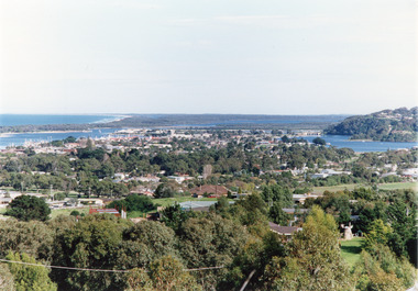 Lakes Entrance Historical Society
Photograph - Township, Tambo Shire, 1990c
Also second copy photographic enlargements of significant sites in the Tambo ShireColor photograph of the township, showing a distant view of the Ninety Mile Beach, the Gippsland Lakes and islands, Kalimna Heights, the bridge over the North Arm, Cunninghame Arm, and a broad view of the town and tree lined streets. Lakes Entrance Victoriabridges, topography, township, waterways -
 Bendigo Historical Society Inc.
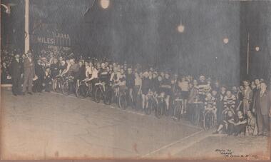
Photograph - GROUP PHOTO OF CYCLISTS/SUPPORTERS, early 1920's ?
Sepia photo: large group of cyclists, with supporters and crowd behind. On LH side of photo: sign with 'miles', numbers 1 - 5, and 'Rowlands' written on bottom of board. In bottom RH side 'Photo by 'Darge' 175 Collins Street, Melbourne.'Darge' 175 Collins St., Melbourne.sport, cycling -
 Lakes Entrance Historical Society
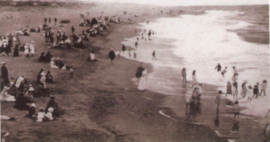
Postcard - Easter Pier beach, 1910c and 1992
Paired photographs used in the 150 years Lakes Entrance 1858 to 2008 display held in 2008. Black and white copy of postcard showing people sitting on beach, children wading in water on ninety mile beach near Eastern pier Lakes Entrance Victoria 1910. Second black and white photograph taken at same location in 1992people, beaches, local history -
 Wodonga & District Historical Society Inc
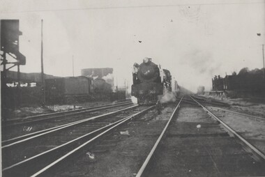
Photograph - Fred Rochow Railways Collection - "Spirit of Progress" test run, November 17, 1937
The Fred Rochow Railways Collection incorporates photos related to the operation of the Wodonga Railway Station including different types of trains and railways staff C. 1930 – 1990. It was donated to the Wodonga Historical Society by Fred Rochow, a railwayman who spent many years based in Wodonga. He joined the Victorian Railways on 17th June l947 and retired in 1988. For some time, he was a member of the Australian Federated Union of Locomotive Enginemen and served a term as a member of the Trades Hall Council. He had an extensive knowledge of the struggles that took place to achieve better conditions for railway workers. Fred worked for many years as a fireman and then worked his way up the ranks to driver, experiencing many changes from the days of steam locomotives through to diesel trains, locomotives and even the modern XPT train. He worked throughout Victoria at different stages of his career, with his final working years focused on the northeast of Victoria and the Albury to Melbourne line. After his retirement, Fred continued to share his love of steam miniature trains with the community.This collection has local and statewide significance as it captures images of trains, locomotives and personnel who operated the railway services in Wodonga and throughout Northeast Victoria. The railways played a critical role in opening up Victoria and connecting Australia for trade, business, social communication and transport.The "Spirit of Progress" on a test run prior to its official launch being hauled by Locomotive S303. It was named the C.J. LaTrobe after the1st Lieutenant-Governor of Victoria, Charles Joseph Latrobe. Considered by many to be Victorian Railways' greatest passenger locomotives, the 4 S class steam locomotives were the first 3 cylinder steam locomotives. This small class was built to run the Melbourne to Albury passenger trains and spent their entire careers on the North East line. They were built unstreamlined and ran in this condition until 1937. The streamlining modifications complimented the all new "Spirit Of Progress" carriages. The S class ran the "Spirit" until 1952 at which time the newly delivered B class diesels took over. The 4 S class locomotive which were allocated to the "Spirit of Progress" were S300 - the "Mathew Flinders", withdrawn in September 1954, having covered 1,379,791 miles. S301 - the "Sir Thomas Mitchell", withdrawn in October 1953, having covered 1,414,367 miles. S302 - the "Edward Henty", withdrawn in July 1954, having covered 1,446,468 miles and S303 - the "C.J. Latrobe", withdrawn in May 1954, having covered 1,434,664 miles.On the lower front of the Locomotive "S303"railways wodonga, fred rochow, wodonga railwaymen, spirit of progress, s class steam locomotives -
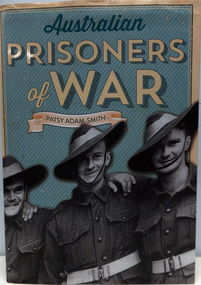 Warrnambool RSL Sub Branch
Book. WW2. Prisoners-of-War, Australian Prisoners of War, 2014
Hardback with dustcoverOriginally published as Prisoners of War by Penguin Books in 1992. This new edition published by The Five Mile Press Ltd. 2014 -
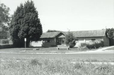 Ringwood and District Historical Society
Photograph, Ringwood Baths, Ringwood Street. 1971
Written on back of photograph, "May 1971. Baths, Ringwood Street, east side between Miles Ave. and Reynolds Ave." -
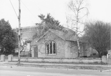 Ringwood and District Historical Society
Photograph, The Gospel Church in Warrandyte Road, Ringwood in 1973, 1973
The Gospel Church in Warrandyte Road in 1973, with Eastland being extended in backgroundWritten on back of photograph, "Gospel Hall, W'dyte Rd. west side, 40 yards south of Miles Ave. 11.7.73" -
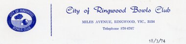 Ringwood and District Historical Society
Document, Ringwood Bowls Club- Letterhead, City of Ringwood Bowls Club, 1974
Copy of Letterhead.City of Ringwood Bowls Club Miles Avenue, Ringwood, Vic., 3134. Telephone: 870 6767. 18/3/74. -
Tatura Irrigation & Wartime Camps Museum
Photograph, Mr TE Williams with bicycle
Mr T E Willilams in jumper and white shorts standing behind his racing bicycleSepia photo of Mr TE Williams with his bicycle. In black plastic frame with glass and L1066Presented to Mr T E Williams. Fastest time 10 Mile Road Race, Kyabram. 31st Sept 1927bicycle, tatura, williams -
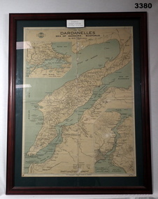 Bendigo Military Museum
Map - MAP GALLIPOLI, FRAMED, H E C Robinson, Post WW1
Brown wooden frame with glass front. Coloured map of Dardanelles featuring the Sea of Marmara & The Bosporus. Mounted on green background with fawn cardboard backing. Map in scale of miles & kilometers. Map shows landings, ships sunk & events during 1915.Back of frame: “Bethany Gallery 116 Bridge Street Bendigo”map, framed, dardenelles, gallipoli, 1915 -
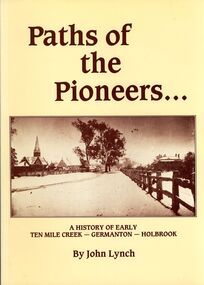 Bendigo Historical Society Inc.
Book - STRAUCH COLLECTION: PATHS OF THE PIONEERS
Soft covered book Paths of the Pioneers, A history of early Ten Mile Creek - Germanton - Holbrook , compiled from the files of the newspapers which have served Germanton, Holbrook, Albury and Wagga Wagga, 104 pages with a map and black & white photographs.John Lynchhistory, australian, new south wales, history-nsw-holbrook-germanton-ten mile creek -
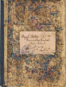 Bendigo Historical Society Inc.
Book - EXERCISE BOOK: KAMAROOKA CENTRAL STATE SCHOOL, 1894
Exercise book belonging to Aggie Miles - Kamarooka Central State School, No. 3182. Contents in neat writing in ink include grammar, arithmetic, geography and hand-drawn maps of Australia, Victoria and Africa. Dated on cover, 1894. See research in Agnes.person, individual, kamarooka state school, kamarooka central state school no. 3182 -
Bendigo Historical Society Inc.
Map - CAMPBELL COLLECTION: BENDIGO AND DISTRICT MAPS
Map. Kimbolton, Parishes of Kimbolton and Lyell, scale 20 chains to 1 inch. Area by Planimeter 6258 acres. Knowsley. 10 1/2 miles to Strathfieldsaye. Campaspe River at bottom right of map. (number 365 in map cupboard 1)map, bendigo, allotments -
Port Melbourne Historical & Preservation Society
Document - Quotation for accommodation, San Mateo Caravan Park, Eight Mile Plains
The Mathews family have been in continuous ownership of 395 Howe Parade (was 8 Howe Parade until 1964 when addresses re-assigned), Port Melbourne from 1938 to the present (Sept 2019)Six folders of assorted documents relating to the life of Alan Mathews and his family. Employment documents. Folder 4 has Motor car purchases, Registration, Licences & RACV San Mateo Caravan Park, Eight Mile Plains. Quotation for accommodationrecreation, alan mathews, commonwealth aircraft corporation, cac -
Moorabbin Air Museum
Photograph (Item) - (SP) Approx 30 various plane photos
-
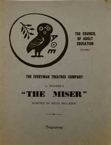 Kew Historical Society Inc
Programme, 'The Miser' by Moliere, 1951
Arthur Henry Dear was an employee of the City of Kew, acting as Hall Keeper of the Kew Recreation Hall in Wellington Street, and later the new Kew City Hall in Cotham Road. The Arthur Dear Collection contains memorabilia - tickets, programmes, invitations - as well as his identification badge. Items in the collection dates from the 1940s to the 1960s. The Kew Recreation Hall (Wellington Street) and later the Kew City Hall (Cotham Road) were major locations in suburban Melbourne in the postwar period for civic and private events including theatre productions and exhibitions. The Arthur Dear Collection (in conjunction with the scrapbooks compiled by Marion Tilley) provide a comprehensive snapshot of performing arts in Kew during the 1940s, 1950s and 1960s. The collection includes valuable data about performances, performers, directors etc., during this period. Programme for a performance of The Miser by Moliere by The Everyman Theatres Company in association with the Council of Adult Education. The text was adapted by Miles Malleson. The 12-page programme includes a cast list, individual performer profiles and notes regarding the history of Everyman Theatres Company. arthur dear collection, performing arts -- kew -- victoria, kew recreation hall -- wellington street, theatre memorabilia, the everyman theatres company -
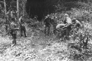 National Vietnam Veterans Museum (NVVM)
Photograph, Gibbons, Denis, Operation Atherton
Denis Gibbons (1937 – 2011) Trained with the Australian Army, before travelling to Vietnam in January 1966, Denis stayed with the 1st Australian Task Force in Nui Dat working as a photographer. For almost five years Gibbons toured with nine Australian infantry battalions, posting compelling war images from within many combat zones before being flown out in late November 1970 after sustaining injuries. The images held within the National Vietnam Veterans Museum make up the Gibbons Collection. A black and white photograph of Diggers from 1 Platoon A Coy 8 RAR on Operation Atherton eleven miles west of Nui Dat prepare for winching a wounded mate out of thick jungle. Casualties were one dead and fourteen woundedphotograph, a coy, operation atherton, gibbons collection catalogue, 8 rar, nui dat, diggers, wounded serviceman, denis gibbons -
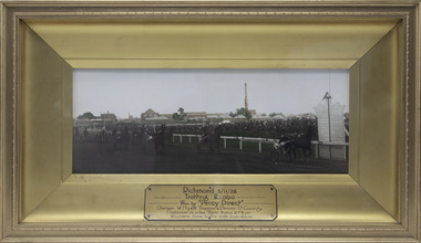 Victorian Harness Racing Heritage Collection at Lord's Raceway Bendigo
Photograph - Framed photo finish, Percy Direct, Richmond 5/11/1928 - Trotting £1000, 5 November 1928
Gold framed, glass covered, Trotting race finish photoRichmond 5/11/1928,Trotting £1000, Won by Percy Direct, Owner W.Hyatt, Trainer Driver "D.George" (G.Daniel). Distance 1 1/2 miles, Time 3 min. 27 3/4 sec, Winners to the mile 2 mins 18 1/2 sec.trotting, richmond, thousand, george daniel, wally hyatt, percy direct, harness racing, 1928, g daniel