Showing 12095 items
matching minister-for-conservation
-
 Koorie Heritage Trust
Education Kit, Aboriginal Affairs Victoria et al, Aboriginal Heritage Bill - Exposure Draft. (2005), 2005
... Department for Victorian Communities ...Exposure draft; sets out the eight objectives of the proposed Act in the protection of Aboriginal cultural heritage in Victoria, strengthen the involvement of Aboriginal people in cultural heritage management; establish an Aboriginal cultural heritage registervii, 110 p. ; 30 cm. 10 information loose sheets; pamphlet folder 32 cm.Exposure draft; sets out the eight objectives of the proposed Act in the protection of Aboriginal cultural heritage in Victoria, strengthen the involvement of Aboriginal people in cultural heritage management; establish an Aboriginal cultural heritage registervictoria. parliament aboriginal heritage bill. | cultural property -- protection -- law and legislation -- victoria. | sacred sites (australian aboriginal) -- law and legislation -- victoria. | law - administrative law - victoria. | cultural heritage - protection. | cultural heritage - repatriation. | cultural heritage - repatriation - human remains. -
Federation University Historical Collection
Book - Nursing Book, Dorothy E. Reilly, Graduate Professional Education Through Outreach: A Nursing Case Study, 1990
... National League for Nursing ...Blue, pink and white soft covered book of 194 pages. non-fictionnursing, margaret stevens, university of ballarat school of nursing, dorothy reilly, dorothy e reilly, staffmember, scarlet fever, diptheria, women -
 Churchill Island Heritage Farm
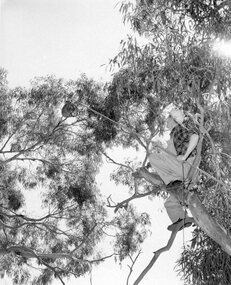
Photograph of man in tree with koala, Unknown
Churchill Island Heritage Farm has a large photograph collection dating from the mid-nineteenth century to the last decade. This series of photographs show conservation and relocation efforts.Black and white photograph taken from a lower viewpoint showing a man in a tree trying to capture a koala for conservationCatalogue number on reverse in pencil. "3" written in pencil on top left cornerchurchill island, photograph, koala, conservation -
 City of Ballarat
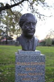
Artwork, other - Public Artwork, Victor Greenhalgh, Harold Edward Holt (Prime Ministers' Walk) by Victor Greenhalgh, c1965
Harold Edward Holt, Australia's 17th Prime Minister, in office from 26 January 1966 to 19 December 1967, when he was officially pronounced dead after drowning at sea. Whitlam’s term abruptly ended when his government was dismissed by the Governor-General on 11 November 1975. The Prime Ministers Avenue is a collection of bronze bust portraits of the Prime Ministers of Australia, located at the Ballarat Botanical Gardens in Ballarat, Victoria. The Prime Ministers' portraits are commissioned after the incumbent term of each Prime Minister by the City of Ballarat. The City of Ballarat has taken responsibility for commissioning the busts after funds set aside by politician Richard Armstrong Crouch were exhausted in 2014. Crouch originally donate money to pay for six busts, the first of which was unveiled in 1940. The collection of prime ministers' busts are unique in Australia, representing the only sculptural portrait collection of all past Australian Prime Ministers. The different styles used reflect the unique artistic practices of the selected artists; textures, sizes and features and proportions are used by the artists to interpret the characteristics of each of the subjects.The artwork is of historic and aesthetic significance to the people of BallaratBronze bust cast on granite plinthHarold Edward Holt Prime Minister 1966-67prime minister, harold edward holt -
 City of Ballarat
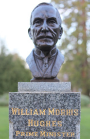
Artwork, other - Public Artwork, Wallace Anderson, William Morris Hughes (Prime Ministers' Walk) by Wallace Anderson, c1940
William Morris Hughes, Australia’s 7th and longest serving Prime Minister until 1957 when Robert Menzies overtook Hughes’ record term from 1915 to 1923. A long standing parliamentarian of 51 years and 7 months continuous service as a member of Australia’s House of Representatives – from the 1st parliament in 1901 to the 20th in 1952. The Prime Ministers Avenue is a collection of bronze bust portraits of the Prime Ministers of Australia, located at the Ballarat Botanical Gardens in Ballarat, Victoria. The Prime Ministers' portraits are commissioned after the incumbent term of each Prime Minister by the City of Ballarat. The City of Ballarat has taken responsibility for commissioning the busts after funds set aside by politician Richard Armstrong Crouch were exhausted in 2014. Crouch originally donate money to pay for six busts, the first of which was unveiled in 1940. The collection of prime ministers' busts are unique in Australia, representing the only sculptural portrait collection of all past Australian Prime Ministers. The different styles used reflect the unique artistic practices of the selected artists; textures, sizes and features and proportions are used by the artists to interpret the characteristics of each of the subjects.The artwork is of historic and aesthetic significance to the people of Ballarat Bronze bust cast on granite plinthWilliam Morris Hughes Prime Minister 1915-23prime minister, australian pm, william morris hughes, parliament -
Friends of Ballarat Botanical Gardens History Group
Work on paper - Statue Valuations, Insurance Valuations of Public Sculptures, fountains and Monuments for the City of Ballarat, 1994, 11 April, 1994, 9/5/94 and 2012
... Monuments for the City of Ballarat, 1994. ...Insurance valuations of public sculptures, fountains and monuments for the City of Ballarat: attention Ian Rossiter. (Town Clerk) valuations prepared by John Jones, Historian, Consultant, Valuer in Australian Art. Print--out contains valuations of the Statues in the Ballarat Botanical Gardens only and the criteria used for updating valuations. Unsigned though very likely written by John Garner.Important in knowing a valuation of each statue in the Ballarat Botanical Gardens in 1994.2 faxes, 1. 1page only. 2.7 pages and 1 copy of 3 pages,(Prime Ministers' busts). 1 page print- out and a copy Fax 1. 11 April 1994. Fax 2. is water damaged. Printed across the top of this fax 94-05-09 11:20 Fax No 6622400. Two folder ring marks on the left hand of each page of the faxes. Fax 2 is signed John Jones on p.6. No marks on print-out. statue valuations, statues of prime ministers, john jones, valuer, city of ballarat, ian rossiter, valuation criteria, value of the statues in the ballarat botanical gardens. total value of ballarat statues in 1994. lists of ballarat statues, sculptors, dates of when the statues were made, marble, slate, granite, bronze, sandstone, john garner collection, garner, dr, ballarat botanical gardens, gardens, ballarat -
 City of Ballarat
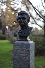
Artwork, other - Public Artwork, Robert James Lee Hawke (Prime Ministers' Walk) by Peter Nicholson, 1984
Robert James Lee Hawke served eight years in office 1983-1991. He became Prime Minister after only two years in parliament. The Prime Ministers Avenue is a collection of bronze bust portraits of the Prime Ministers of Australia, located at the Ballarat Botanical Gardens in Ballarat, Victoria. The Prime Ministers' portraits are commissioned after the incumbent term of each Prime Minister by the City of Ballarat. The City of Ballarat has taken responsibility for commissioning the busts after funds set aside by politician Richard Armstrong Crouch were exhausted in 2014. Crouch originally donate money to pay for six busts, the first of which was unveiled in 1940. The collection of prime ministers' busts are unique in Australia, representing the only sculptural portrait collection of all past Australian Prime Ministers. The different styles used reflect the unique artistic practices of the selected artists; textures, sizes and features and proportions are used by the artists to interpret the characteristics of each of the subjects.The artwork is of historic and aesthetic significance to the people of BallaratBronze bust cast on granite plinthRobert James Lee Hawke Prime Minister 1983-1991prime minister, bob hawke, australian hstory, parliament of australia, hawke -
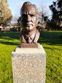 City of Ballarat
Artwork, other - Public Artwork, Wallace Anderson, John Curtin Prime (Prime Ministers' Walk) by Wallace Anderson, c1940
John Curtin, Australia's 14th Prime Minister served 1941-1945 and during World War II. The Prime Ministers Avenue is a collection of bronze bust portraits of the Prime Ministers of Australia, located at the Ballarat Botanical Gardens in Ballarat, Victoria. The Prime Ministers' portraits are commissioned after the incumbent term of each Prime Minister by the City of Ballarat. The City of Ballarat has taken responsibility for commissioning the busts after funds set aside by politician Richard Armstrong Crouch were exhausted in 2014. Crouch originally donate money to pay for six busts, the first of which was unveiled in 1940. The collection of prime ministers' busts are unique in Australia, representing the only sculptural portrait collection of all past Australian Prime Ministers. The different styles used reflect the unique artistic practices of the selected artists; textures, sizes and features and proportions are used by the artists to interpret the characteristics of each of the subjects.The artwork is of historic and aesthetic significance to the people of BallaratBronze bust cast on granite plinthJohn Curtin Born Creswick Prime Minister 1941-45prime minister, john curtin, world war ii, richard armstrong crouch, ballarat botanical gardens -
 Whitehorse Historical Society Inc.
Book, Calling and recalling, 1984
One minister's pilgrimage. into the Uniting Church.One minister's pilgrimage. into the Uniting Church. Autobiography of Rhys Miller as a Presbyterian and then Uniting Church minister. Includes much concerning the negotiations leading to Union, also the Matheson Family through his wife Marny.One minister's pilgrimage. into the Uniting Church. uniting church, presbyterian church, miller, rhys, matheson family -
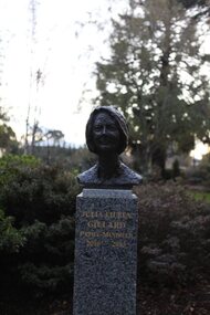 City of Ballarat
Artwork, other - Public Artwork, Julia Eileen Gillard (Prime Ministers Walk) by Peter Nicholson
Julia Eileen Gillard, Australia's 27th Prime Minister, on 24 June 2010 Julia Gillard became Prime Minister and the first woman to hold the office. She was elected unopposed by the Parliamentary Labor Party. The Prime Ministers walk at Ballarat Botanical Gardens has over time created a special and unique understanding of our Prime Ministers and the strength of belief, passion and understanding we had for these leaders. The different styles used reflect the times and the techniques used to undertake these portraits of leaders makes us consider those elements of official portraiture, including textures, sizes and features and proportions used by some of the artists. The artwork is of aesthetic and historic significance to the people of BallaratBronze bust cast on granite and concrete plinth.Julia Eileen Gillard Prime Minister 2010 - 2013prime minister, australian pm -
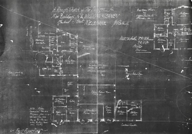 Mission to Seafarers Victoria
Drawing - Architectural drawing, photocopy, Walter Butler, A Rough Sketch of the Design for the New Buildings for the Missions to Seamen, Flinders Street, Melbourne, c. 1916
... A Rough Sketch of the Design for the New Buildings for the ...Rough sketch for the new Flinders Street building designed by Walter Richmond Butler. The copy was published in the 2002 conservation plan without mentionne the source. The original has not been located.The drawing shows the first design of the chapel, the intented position of the weathervane, the absence of chaplain's residence and dome.2 A3 photocopies glued in black and white of an architectural drawing depicting the facade.walter richmond butler (1864–1949), flinders street, building, sketch, built heritage -
 Orbost & District Historical Society
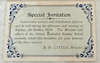
invitation, 1930
The Orbost Methodist Church began services in April 1910, the Rev. E. Hooper as the first minister. Reverend R.W. Little was minister in 1930-31.Ministers at that time batched either in a little room at the back of the church or in Locksley House (near the state school). Sunday School at that time involved a lot of commitment on the part of the teachers towards the children and this was reflected in the efforts they went to to make Sunday School an interesting and enjoyable event. The Sunday School Anniversaries were always a big community event and children usually dressed up for the occasion. The children spent weeks practising hymns and choruses for the occasion and on the Saturday before picked armfuls of flowers from Mrs Hocking's garden ( may blossoms) to decorate the church hall. (ref. Pioneers and Pilgrims Revd Peter Gador-White).For many years the Methodist people of Orbost enjoyed the fellowship of the church and the children, in particular, were socially and spiritually involved. This item is reminiscent of that time.A rectangular cardboard invitation to a service and prize-giving at the Orbost Methodist Sunday School. The print is black on a pale blue background with a black frame and floral decorations in each cornerSpecial Invitation R.W. Little, Ministerorbost-methodist-church sunday-school -
 Orbost & District Historical Society
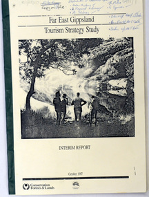
book / document, Far East Gippsland Tourism Strategy Oct 1987, October 1987
The project team for this document comprised E. Beacham, T. Claridge, B. Ebbs, C. Wilso. and J. Cristofaro.This booklet is a useful refernce tool.A document of 86 pp, titled Far East Gippsland Tourism Strategy Study Interim Report October 1987. it has a cream cover and black binding with a b/w photograph of four people in a bushland setting. It contains fold-out maps.tourism-east-gippsland -
 Orbost & District Historical Society
Document - File Folder, A History of Aboriginal People of East Gippsland, January 1985
This item is a useful reference tool on the history of Indigenous People in East Gippsland and the Orbost district. A manilla folder with typed pages. On the cover is a label, "History of Aboriginal People of East Gippsland". On the inside cover is a letter addressed to the librarian at the Shire of Orbost Library. The letter is clipped to the inside of the folder.on front cover - a stamp -"Orbost Historical Society"aboriginal australians, gippsland aboriginal history, kurnai, brabawooloong peoples, tatungooloong peoples, krowathunkooloong peoples -
![Book - Map, Land Conservation Council, Melbourne Study Area Report, [December 1973]](/media/collectors/4f729f7b97f83e03086018a5/items/6469bc241d76dd4b008a829f/item-media/646b0013d841f8920fa4323c/item-fit-380x285.jpg) Eltham District Historical Society Inc
Eltham District Historical Society IncBook - Map, Land Conservation Council, Melbourne Study Area Report, [December 1973]
The Melbourne Study Report is a series of volumes describing the physical nature of the land and its environment, examines the likely forms of land use, and assesses the hazards associated with these uses. This is Volume 2 (coloured maps). The first page featues a black and white map described as "Shire of Diamond Valley" with public land marked in yellow. Followed by eight large fold out maps. Melbourne Study Area Public land and descriptive blocks, Population description, Geology, Physiography, topography and rainfall, vegetation and water supply. The Land Conservation Act 1970 established the Land Conservation Council whose functions is to "carry out investigations and make recommendations to the Minister with respect to the use of public land in order to provide for the balanced use of land in Victoria. This report sets out to describe and assess the natural resources of the public lands in the Melbourne area and provides a factual basis on which members of the community may base submissions to the [Land Conservation] Council of Victoria.A collection of eight large fold out coloured maps published in a bound book formnon-fictionThe Melbourne Study Report is a series of volumes describing the physical nature of the land and its environment, examines the likely forms of land use, and assesses the hazards associated with these uses. This is Volume 2 (coloured maps). The first page featues a black and white map described as "Shire of Diamond Valley" with public land marked in yellow. Followed by eight large fold out maps. Melbourne Study Area Public land and descriptive blocks, Population description, Geology, Physiography, topography and rainfall, vegetation and water supply. The Land Conservation Act 1970 established the Land Conservation Council whose functions is to "carry out investigations and make recommendations to the Minister with respect to the use of public land in order to provide for the balanced use of land in Victoria. This report sets out to describe and assess the natural resources of the public lands in the Melbourne area and provides a factual basis on which members of the community may base submissions to the [Land Conservation] Council of Victoria. maps, shire of diamond valley, population, geology, topography, rainfall, vegetation, water supply, land use, public lands -
 Eltham District Historical Society Inc
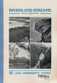
Book, Land Conservation Council, Rivers and Streams: Special Investigation, September 1989
In June 1987, the government directed the LCC to carry out a special investigation of the social, recreational, cultural and ecological values of rivers and streams in Victoria, and to make recommendations on the use of these rivers and how their identified values can best be protected. Notices announcing the commencement of the investigation were published in the Victoria Government Gazette and in Victorian newspapers in November 1987. A descriptive report was published in September 1989. The Council received 75 submissions following the publication of this report. After considering these submissions, the Council formulated its proposed recommendations, which were published in November 1990. The Council received 177 submissions commenting on the proposed recommendations. The Council published its final recommendations in June 1991. While welcomed by many, the study cut across the interests of other groups and was perceived to be particularly threatening to water authorities. The investigation resulted in a legislated system of 17 heritage rivers (with significant natural, recreational, scenic and heritage values) and natural catchment areas across Victoria. -
 Eltham District Historical Society Inc
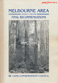
Book, Land Conservation Council, Melbourne Area, District 2 Review: Final Recommendations, 1994
Notices showing the boundary of the area of the review and advising that an investigation was to be carried out were published in the Victoria Government Gazette and in local and other Victorian newspapers in May 1987. A descriptive resources report was published in August 1991. Council received 1,425 submissions and letters following publication of the descriptive report. The Council considered these submissions and published proposed recommendations in April 1993. A further 1,993 submissions were received in response to the proposed recommendations. The Council published its final recommendations in July 1994. A change to legislation in 1989 enabled the LCC to make recommendations for public land within a ‘town’, though cities and rural cities remained excluded from the definition of public land. Timber resources and water quality and yield from timbered catchment areas remained significant issues in Melbourne’s catchments. Recommendations for the Yarra Ranges National Park were based around the closed Melbourne water catchments and adjoining state forest. A recommended Phillip Island State Park based around the penguin reserve was ultimately implemented as the Phillip Island Nature Park.Shire of Nillumbik DPE/Enviro -
 Marysville & District Historical Society
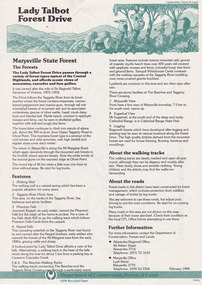
Flyer (item) - Information Flyer, Department of Conservation, Forests & Lands, Lady Talbot Forest Drive, February 1988
A flyer with information on Lady Talbot Forest Drive and the attractions in the area surrounding it.A flyer with information on Lady Talbot Forest Drive and the attractions in the area surrounding it. Lady Talbot Drive a 24 kilometer scenic rainforest car journey which passes a number of walks and waterfalls in the Yarra Ranges National Park. Lady Talbot Drive is named after Lady Sarah Elizabeth, the wife of Sir Reginald Talbot, who was the Governor of Victoria from 25th April, 1904 to 6th July 1908.7761(F1)lady talbot drive, lady talbot forest drive, marysville state forest, sir reginald talbot, lady sarah elizabeth talbot, wishing well, taggerty river, phantom falls, keppel falls, beeches walking track, marysville, mount sugarloaf, logging, victoria, walking tracks -
 Marysville & District Historical Society
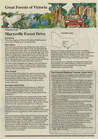
Flyer (item) - Information Flyer, Conservation & Environment, Great Forests of Victoria-Marysville Forest Drive, Pre 2009
A flyer with information on the Marysville Forest Drive in Victoria and the sights and attractions to be found along the drive.A flyer with information on the Marysville Forest Drive in Victoria and the sights and attractions to be found along the drive.marysville forest drive, conservation and environment, victoria, forest, state forest -
 Mission to Seafarers Victoria
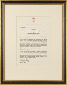
Letter - Framed letter, Michael Jeffery, A Message from His Excellency Major General Michael Jeffery, 23 August 2007
Letter sent by the Governor General for the centenary of the Seafarers Service.Mounted and framed typewritten letter on cream colour paper.Signed by Governor General Michael Jeffery and dated 23 August 2007michael jeffery, governor general, 2007, centenary, acacia, crown, golden wattle, seafarers service -
 Greensborough Historical Society
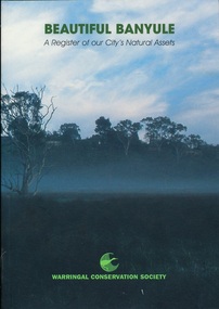
Book, Beautiful Banyule: by Carol Toomey, 1999_
A record of reserves and their features in the City of Banyule 1999. Full title: Beautiful Banyule: a register of out city's natural assets.A register of Banyule's natural assets104 pages, colour illustrations.Soft cover with treed skyline on front cover. 2 copies.Library labels.city of banyule, parks banyule, gardens banyule, historical sites banyule. -
 Greensborough Historical Society
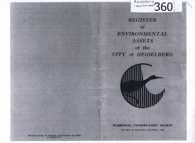
Booklet, Register of environmental assets of the City of Heidelberg 1977, 1978_
This is the first list of environmental assets within the City of Heidelberg (1977) and lists major parklands, small neighbourhood parks, trees of note and landscapes.An early list of environmental assets in Heidelberg, has been superseded by Strategies and Policies on the Banyule Council website.Photocopy of 28 page booklet. Copied 2 pages to an A4 sheet. heidelberg, environmental assets, city of heidelberg, parks -
 Marysville & District Historical Society
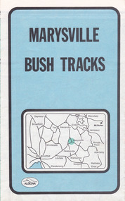
Map (Item) - Bush tracks map, John Siseman et al, MARYSVILLE BUSH TRACKS, 1987
A fold out map of the bush tracks in and around Marysville with information regarding each track. This map was published by Pindari Publications and distributed by Algona Publications. The track notes were compiled by John Siseman in 1987. The map was drawn by Glenn van der Knijff.A fold out map of the bush tracks in and around Marysville with information regarding each track.marysville, victoria, australia, map, bush tracks, pindari publications, algona publications, john siseman, gleen van der knijff, lady talbot forest drive, beauty spot walk, michaeldene track, steavenson falls, tree fern gully walk, trestle track, phantom falls, marysville town walk, marysville lookouts round walk, keppel falls, the beeches round walk, cumberland scenic reserve, cambarville, lake mountain, lake mountain walking track -
Tatura Irrigation & Wartime Camps Museum
Folder, Department Conservation and Natural Resources et al, Rushworth Waranga, 2003
Report on mines, including Balaclava, extracts from Waranga News. Early happening settlement life.Black with metal clips. Labels on spine.rushworth, waranga, balaclava mines -
Lakes Entrance Regional Historical Society (operating as Lakes Entrance History Centre & Museum)
Book, Department of Conservation Forests and Lands, Draft Gippsland Fisheries Management Plan, 1989
Provides information and inviting public comment and discussion on the management of the Gippsland Lakes Victoria.wetlands, recreation, waterways -
Lakes Entrance Regional Historical Society (operating as Lakes Entrance History Centre & Museum)
Book, Department of Conservation and Natural Resources, Participants in Progress, 1995
Draft management plan inviting comments from all user groups of the Gippsland Lakes Victoriafishing industry, recreation, birds -
Lakes Entrance Regional Historical Society (operating as Lakes Entrance History Centre & Museum)
Book, Department of Conservation and Natural Resources, Celebrating CFA Women- Recognising Womens contributions to CFA
Draft management plan for sustaining the fisheries and fish resources of the Gippsland Lakes, considering both recreational and commercial activities and ecological impact on all other biological species of the lakes.fishing industry, waterways -
Lakes Entrance Regional Historical Society (operating as Lakes Entrance History Centre & Museum)
Book, Department of Conservation Forests and Land with Save the Gippsland Lakes Committee, Eden Woodchips, 1988
Collected submissions and discussion papers from the Gippsland Lakes Algal Bloom Seminar held in Bairnsdalemanagement, waterways -
Lakes Entrance Regional Historical Society (operating as Lakes Entrance History Centre & Museum)
Book, A Study of Land in the Catchment of the Gippslnd Lakes Vol 1, 1988
108 printed pages in report, wire spiral boundBlue cardboard cover with title printed in golddocuments, reports -
Lakes Entrance Regional Historical Society (operating as Lakes Entrance History Centre & Museum)
Book, A Study of Land in Catchment of the Gippsland Lakes Vol 2, 1992
504 printed pages, a map is included inside front coverBlue cardboard cover with title printed in gold, title also printed on spine in golddocuments, reports