Showing 1084 items matching "monuments"
-
 Eltham District Historical Society Inc
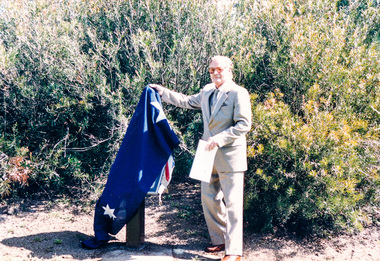
Photograph, Sinking the capsule, Graham Beyer on left and Joh Ebeli, Time Capsule Ceremony, 10 November, 1985, 10/11/1985
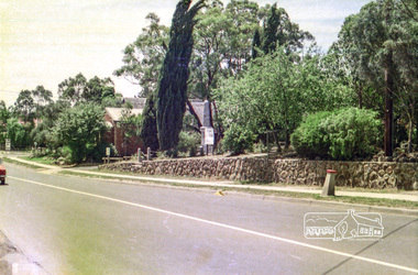
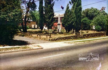
On Sunday, 10 November 1985 a time capsule was lowered into a monument installed near the corner of Main Road and Pitt Street in Eltham, within the gardens at the front of what is now the Eltham Community and Reception Centre. This monument commemorates Victoria’s 150th anniversary and the former location of the Eltham Town Centre, which existed along this section of Main Road, then known as Maria Street. Beneath the site is a time capsule to be opened in the year 2035. A plaque was also erected at this site in October 1987 to commemorate the Shire of Eltham Historical Society’s 20th anniversary. The main feature of this monument is a ‘tyring disc’, a blacksmith’s implement that was found on this site. This consists of a large iron disc that was used as a platform for fitting iron tyres (like the one shown on top of the platform) to wooden-spoked cart wheels. The local blacksmith and wheelwright worked together to assemble the wheel, which was clamped to the platform placed close to the fire. The red-hot iron hoop, previously forged to the correct size, was lifted with tongs by the blacksmith over the outside of the rim, then hammered down amid flames from the scorching timber. The wheelwright drenched the tyre with cold water as soon as it was in position. A clamp placed on the naff (hub) and screwed down tightly kept the spokes at a constant angle as the tyre cooled. An even pressure from the contracting tyre tightened the joints at each end of the spokes and formed a vice-like grip, which would last for the life of the wheel. [from EDHS Newsletter No. 45, November 1985:] TIME CAPSULE CEREMONY: Our 150th Anniversary Monument is now under construction in the gardens in front of the Eltham Community Centre. Further details of the project are given under a separate heading below and this item deals with the proposed ceremony. We propose to formally lower the time capsule into its container underneath the monument as part of the Eltham Community Festival. All members are invited to attend the ceremony at 2.00 p.m. on Sunday, 10th November. Come earlier with a picnic lunch if you like. Local people and firms who have contributed money or services for the monument will also be invited. As part of the Festival programme the public are welcome to attend. This is one of the most significant projects the Society has undertaken and members' participation in its finalization would be most gratifying to the organizing committee. 150TH ANNIVERSARY PROJECTS: We have concentrated our efforts on finishing the monument and time capsule project within the 150th year and have found it necessary to abandon the historical tour project. We have applied to the State 150th Committee to transfer the funds allocated for the tour to construction of the monument. The historical tour project will be continued at a later date and photos of historic houses in the area, taken by Doug Orford, will be available for use in an associated display. At the time of writing, the monument construction is on schedule for the ceremony on 10th November. The concrete base has been completed and the main feature of the monument, which is an old tyring plate or disc, will be lifted into place in the next week. The final ceremony will involve lowering the sealed time capsule into place, bolting down its container lid and then concreting over the lid. The capsule will contain mainly items relating to present day Eltham and its people and is to be opened in the year 2035, a video film made by Joh Ebeli and also details of families and organizations who have contributed to construction of the monument. It is proposed to place the items in the capsule on 5th November and any items members think could be included may be submitted up to that date. The Society has received an excellent response from local people, firms and organizations by way of assistance with this project. Graham Beyer, who originated the project, has arranged many of the donations. He and his firm, Package Handling Equipment, have donated the time capsule itself and have carried out fabrication of sections of the monument. The design of the monument was adapted by Graham Beyer from drawings by Joh Ebeli. Charmac Industries has donated the container for the time capsule and a cast gun metal name plate for the monument. BMG Concrete has donated concrete for the base which was constructed by Caridi Construction Company. Northbourne Garden Supplies has donated materials for the paving around the monument. Robert Becker from Eltham Apex directed construction of the paving by Society members. Terry Hutchinson has agreed to donate the use of his crane to lift the tyring disc into place. Financial contributions have been made by the Eltham Chamber of Commerce and the Rotary Club of Eltham. We are grateful to all who have helped, and members' support for firms who have donated their services would be an appropriate recognition. It is planned to print "Time Capsule Certificates" which can be held by organizations or passed on to descendants by individuals. The certificates will indicate an interest in the contents of the capsule when it is opened in fifty years. Certificates will be distributed to Society members and those who have contributed to the project.Colour photographactivities, 1985, time capsule, eltham, eltham festival -
![Photograph - Digital Image, Grave of William Poulter and Mary Chapman Poulter, Greensborough Cemetery [damaged headstone], 13/03/1888](/media/collectors/4f729f5697f83e03086015b8/items/54c5d7782162f117305391b6/item-media/54c5d7b92162f11730539655/item-fit-380x285.jpg) Greensborough Historical Society
Greensborough Historical SocietyPhotograph - Digital Image, Grave of William Poulter and Mary Chapman Poulter, Greensborough Cemetery [damaged headstone], 13/03/1888
Grave of William Poulter (died 13/03/1888) and Mary Poulter (died 18/09/1899) in Plot#B8 Greensborough Cemetery. This damaged monument was restored to its former position.Greensborough Cemetery was created when land was given for the cemetery by Mr William Poulter, a local settler, about 1864. The cemetery holds the graves of many early settlers in the district. Digital copy of colour photograph of grave/headstone.william poulter, mary poulter, greensborough cemetery -
 Bendigo Military Museum
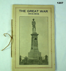
Booklet, HG Armor & Sons Printers Mausfield, The Great War 1914-1918, 1921
The roll is the Bonnie Doon District 1914 - 18. There seven people with the same surname “Jury” on the rollBeige cardboard folded booklet. Front cover has title in blue print with B&W photo of statue of soldier on granite monument with list of names. Back cover has blue print and red and blue flag. Booklet tied with beige cord.documents-pamphlets, military history-army, bonnie doon -
 Bendigo Historical Society Inc.
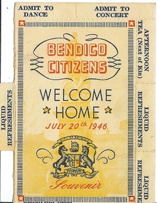
Document - BASIL MILLER COLLECTION: WELCOME HOME 1946
Bendigo citizens welcome home July 20, 1946, souvenir, Crest of City of Bendigo, Colour printed ticket with watermark image of Gold Monument in background. Vouchers for drinks, dance, and concert, around edge. Two missing. See 4095 Folder 6 .person, individual, basil miller -
 Bendigo Historical Society Inc.
Postcard - ROSALIND PARK,BENDIGO, VICTORIA
Sepia photograph Rosalind Park Bendigo, Postcard format. Photograph includes unsealed path, pavers, hedge, quite large trees, monument that has a life size man's head and shoulders, writing below. Postcard published by 'The Rose Stereographs' Armadale, VictoriaThe 'Rose' series De Luxe P.3180photo, garden, rosalind park, postcard, rosalind park bendigo, photograph, the rose series p.3180, monument -
Clunes Museum
Newspaper - NEWSPAPER /CUTTING, 1933
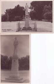
IT SHOWS THE FOUNTAIN IN THE GARDEN, SHIRE HALL, MAIN STREET FROM THE WEST, THE SHOPPING CENTRE, THE STATE SCHOOL PANORAMA, THE STATE SCHOOL SCHOLARS. A CORNER OF THE TOWN. WAR MEMORIAL, GOLD DISCOVERY MONUMENT. E.SA BANK & A PRETTY STRETCH OF THE CREEK, KNITTING MILL.local history, document, newspaper cutting, weickhardt family -
 Surrey Hills Historical Society Collection
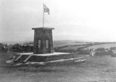
photograph, Ken Hall, Beckett Park Soldiers War Memorial c1932, c1980
Copy negative by Ken Hall from a c1933 City of Camberwell brochure. The original appears to have had a crease mark across it as this is evident on both copies.Black and white photo of the First World War memorial erected on the high point in Beckett Park, Balwyn. Taken with the memorial in the foreground and looking to the south-west. The Australian flag is flying on top of the monument and in the background are rows of trees dividing largely clear land.On the rear: Copy 1: "1153 Repeat of No 164" in top left hand corner in lead pencil in Jocelyn Hall's hand. Copy 2: "1153 Repeat of No 164" in top left hand corner in lead pencil in Jocelyn Hall's hand and "Soldiers War Memorial / Beckett Park / Erected 1918" in blue biro centre right.first world war, war memorial, beckett park -
Clunes Museum
Book, ROB WIGHT, CLUNES WAR MEMORIAL WW1
DESCRIPTION OF SOLDIERS IN WW1 WHOSE NAMES ARE ON THE WAR MEMORIAL IN CLUNESCLEAR FRONT COVER, BLACK CARDBOARD BACK COVER, SPIRAL BOUND FRONT COVER IS A COLOURED IMAGED OF THE CLUNES WAR MEMORIAL, A SOLDIER ATOP A PLINTH WITH NAMES OF MILITARY PERSONNEL ENGRAVED IN GOLD LETTERING. MONUMENT IS SURROUNDED WITH WHITE METAL FENCE PANES.non-fictionDESCRIPTION OF SOLDIERS IN WW1 WHOSE NAMES ARE ON THE WAR MEMORIAL IN CLUNESsoldiers ww1, rob wight, war memorial -
 Buninyong & District Historical Society
Photograph - Photograph of Buninyong from Mt. Innes, 1993
historic, buildings, landscapeB/W photograph of Buninyong town from Mt Innes, looking west, with George Innes monuments in foreground. Now known as Birdwood Park, earlier named Birdwood Grove in 1917 as part of the Avenue of Honor. The land was donated to Buninyong by George Innes.buninyong, mt. innes, george innes -
 Eltham District Historical Society Inc
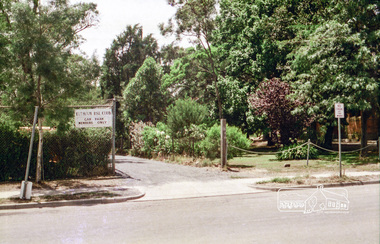
Photograph, Peter Bassett-Smith, Unveiling ceremony of the Memorial Plaque at corner of Main Road and Pitt Street, Eltham commemorating the 20th Anniversary of Eltham District Historical Society, 10 October 1987, 10/10/1987
Joh Ebeli unveiling plaque commemorating the Shire of Eltham Historical Society’s 20th Anniversary. The commemorative plaque explains the functions of the various items used in the Victorian 150th Anniversary Monument and Time capsule.Two colour photographs1987, activities, eltham community centre, time capsule -
Tatura Irrigation & Wartime Camps Museum
Photograph - copy, D. Clark, Hogan Street Tatura, 1989 copy
This copy of photograph taken from a post card. Shows palm tree in front of bakery, now gone. Old Post Office, garage, now Max's supermarket. Criterion Hotel and clock monumentBlack and white copy photograph of Hogan Street, Tatura. c 1950on back: Hogan Street, Taturahogan street tatura -
 Eltham District Historical Society Inc
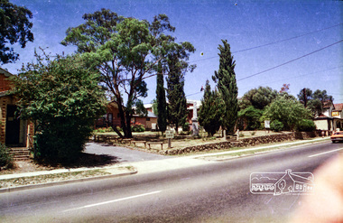
Photograph, Eltham RSL and Uniting Church, Main Road, Eltham, c.1979, 1979c
... monuments ...Changing streetscape - RSL branch merged with Montmorency. Land sold and since developed into units.Roll of 35mm colour negative film, 6 stripsUnidentified; half-frame numberingmonuments, church, eltham rsl sub-branch, eltham uniting church, main road -
 Eltham District Historical Society Inc
Photograph, Eltham RSL and Uniting Church, Main Road, Eltham, c.1979, 1979c
... monuments ...Changing streetscape - RSL branch merged with Montmorency. Land sold and since developed into units.Roll of 35mm colour negative film, 6 stripsUnidentified; half-frame numberingmonuments, church, eltham rsl sub-branch, eltham uniting church, main road -
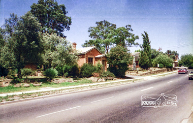
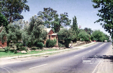
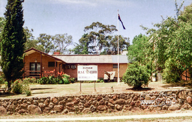
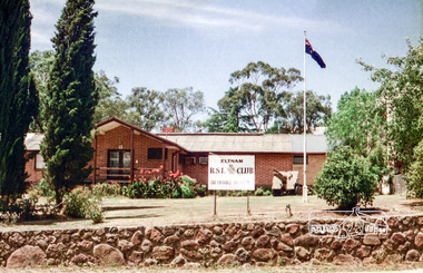 Eltham District Historical Society Inc
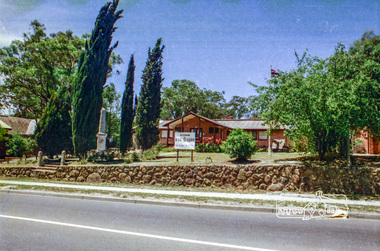
Photograph, Eltham RSL and Uniting Church, Main Road, Eltham, 1979c
... monuments ...Once a row of shops wase situated here and then the Eltham RSL sub branch occupied this site from the 1950s. The War Memorial obelisk was relocated here from it oriiginal site and situated in front of the building. After the branch amalgamated with Montmorency in 2012, the building was subsequently sold and demolished. The memorial was relocated. Units now occupy the site. Changing streetscapeRoll of 35mm colour negative film, 6 stripsUnidentified; half-frame numberingmonuments, church, eltham rsl sub-branch, eltham uniting church, main road -
 Eltham District Historical Society Inc
Photograph, Eltham RSL and Uniting Church, Main Road, Eltham, c.1979, 1979c
... monuments ...Changing streetscape - RSL branch merged with Montmorency. Land sold and since developed into units.Roll of 35mm colour negative film, 6 stripsUnidentified; half-frame numberingmonuments, church, eltham rsl sub-branch, eltham uniting church, main road -
 Eltham District Historical Society Inc
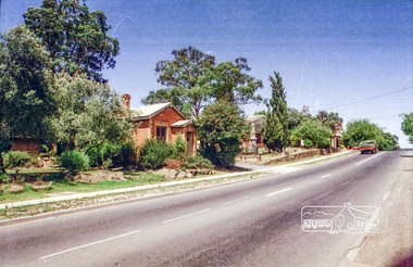
Photograph, Eltham RSL carpark entrance, Pitt Street, Eltham, c.1979
... monuments ...Changing streetscape - RSL branch merged with Montmorency. Land sold and since developed into units.Roll of 35mm colour negative film, 6 stripsUnidentified; half-frame numberingmonuments, church, eltham rsl sub-branch, eltham uniting church, main road -
 Eltham District Historical Society Inc
Photograph, Eltham RSL and Uniting Church, Main Road, Eltham, c.1979, 1979c
... monuments ...Changing streetscape - RSL branch merged with Montmorency. Land sold and since developed into units.Roll of 35mm colour negative film, 6 stripsUnidentified; half-frame numberingmonuments, church, eltham rsl sub-branch, eltham uniting church, main road -
 Clunes Museum
Photograph
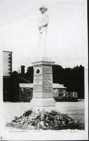
... MONUMENTS ...MEMORIAL ERECTED IN HONOUR OF ALL WHO INLISTED FROM TOWN AND DISTRICT FOR THE GREAT WAR 1914-18.PHOTOGRAPH OF SOLDIERS MEMORIAL - WITHOUT FENCELEST WE FORGETlocal history, photography, photographs, monuments, memorials.soldiers&gold -
 Clunes Museum
Photograph, UNKNOWN
... monuments ...BLACK & WHITE POSTCARD PHOTOGRAPH SOLDIERS MEMORIAL, CLUNES, CORNER FRASER STREET AND SERVICE STREET, CLUNES. local history, photography, photograph, monuments, memorials soldiers gold -
 Rutherglen Historical Society
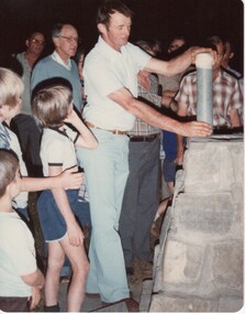
Image, 23/11/1980
... monuments ...Colour photograph of a man about to lower a sealed time capsule into a cairn.On back of photo: "John Williams placing time capsule in cairn. Rutherglen Showgrounds 23-11-80"rutherglen showgrounds, time capsule, cairn, monuments, john williams -
 Rutherglen Historical Society
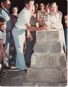
Image, 23/11/1980
... monuments ...Colour photograph of a man lowering a time capsule into a cairn.On back of photo: "John Williams. Rutherglen Showgrounds 23-11-80"time capsule, cairn, rutherglen showgrounds, monuments, john williams -
 Rutherglen Historical Society
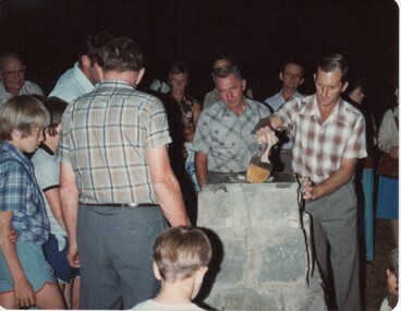
Image, 23/11/1980
... monuments ...Colour photograph of a group of people around a stone cairn, one of the men applying sealant to the top.On back of photo: "Don Nash sealing time capsule in cairn at Rutherglen Showgrounds 23-11-80"time capsule, rutherglen showgrounds, cairn, monuments, don nash -
 Rutherglen Historical Society
Image, 23/11/1980
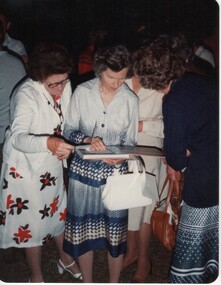
... monuments ...Miss Florence Iggsten had attended school and the Rutherglen Common School, and later was a teacher there. She was also one of the founding members of the Rutherglen Historical Society. This photo was taken on the occasion of the erection of the cairn, with its time capsule, at the Rutherglen Showgrounds in 1980.Colour photograph of several women examining a book at the Rutherglen Showgrounds, on the occasion of the sealing of the time capsule.On back of photo: "Miss Iggsten. Rutherglen Showgrounds 23-11-80"rutherglen showgrounds, time capsule, cairn, monuments, florence iggsten -
 Bendigo Historical Society Inc.
Document - MCCOLL, RANKIN AND STANISTREET COLLECTION: RENT RECEIPTS, 1930/40
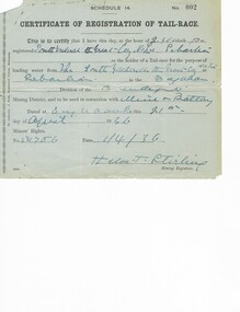
1. Rent receipts, permissive occupancy, Monument Hill Consolidated. 2. Right to occupy a residence area, Victoria Phillipa Evans 127 Breen Street Bendigo. 3. Plan for applied Lease 10423. 5. Certificate of Registration of tail race. Loose documents.MCCOLL RANKIN & STANISTREETorganization, business, industrial - mining, mccoll rankin & stanistreet