Showing 8594 items
matching orbost-floods-1978
-
 Melbourne Tram Museum
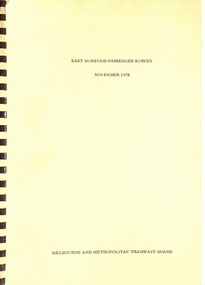
Document - Report, Melbourne & Metropolitan Tramways Board (MMTB), "East Burwood Passenger Survey November 1978", Nov. 1978
Report -A4 bound with brown comb binder, 45 pages + fawn covers, titled "East Burwood Passenger Survey November 1978".. Contents include passenger origins, access modes, trip purpose, frequency, destinations and comments. Has 14 appendices, Not all sheets scannedtrams, tramways, east burwood, new tramways, passengers, surveys -
 Greensborough Historical Society
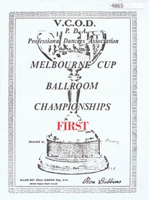
Certificate, V. C. O. D. Professional Dancers Association, Melbourne Cup Ballroom Championships 1978, 02/11/1978
Certificate of achievement to Rosalie and Matt Bray for Fox Trot in the Melbourne Cup Ballroom Championships 1978.Black and red print, off-white paperFirst [prize] awarded to Matt and Rosalie Bray, Melbourne Cup Ballroom Championships event: Fox trot, 2.11.1978dancing, rosie bray -
 Bialik College
Photograph, Football team, 1978, 1978
Bialik football team with coach, 1978. Please contact [email protected] to request access to this record.sport, 1970s -
 Greensborough Historical Society
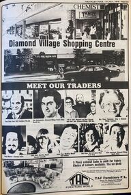
Newspaper - Newspaper Clipping - Digital Image, The Valley Voice, Diamond Village Shopping Centre, Watsonia, 1978, 27/07/1978
Diamond Village Shopping Centre, Watsonia, 1978. A full page advertisement introducing the shopkeepers at this location.Digital copy of newspaper articlediamond village shopping centre, watsonia -
 Orbost & District Historical Society
credit ledger, 1892-1909
This ledger was used by the Shire of Orbost from 1892 - 1909. The item was donated to Orbost & District Historical society from P.R.O.V. as a Place of Deposit (POD) item for safe keeping by a local history group or museum. The shire covered an area of 9,347 square kilometres and existed from 1892 until 1994 when it became part of the East Gippsland Shire Council. Orbost was at first included in the Bairnsdale Shire from 1882 and was later part of the Tambo Shire. Because of travelling distances the Croajingalong Shire was created in 1892 (name changed to Orbost Shire 17.2.1893 with James Cameron as the first Shire President. In 1994 it amalgamated to become part of East Gippsland Shire Council. This is a hand-written record of the accounts of the local government. The Orbost Shire Council no longer exists having been absorbed into the East Gippsland Shire Council.A heavy ledger with a dark brown cover and lighter brown binding. it has marbled end covers and marbled page edges. It contains accounts records hand-written in ink.on spine in gold lettering - on a red square : "Ledger" - on a black square : "Shire of Orbost"accounts ledger orbost-shire-council -
Ringwood and District Historical Society
Envelope, Packet: Ringwood Directories 1965, Who's Who 1960.. Living in Ringwood 1978
1. Life and living in Ringwood 1978; 2. Who's who in Ringwood 1960; 3. Business directory of Ringwood & district 1965. -
 Orbost & District Historical Society
ledger, late 1950's - 1970's
This ledger was used by the Shire of Orbost in the late 1950's - 1970's.The item was donated to Orbost & District Historical society from P.R.O.V. as a Place of Deposit (POD) item for safe keeping by a local history group or museum. The shire covered an area of 9,347 square kilometres and existed from 1892 until 1994 when it became part of the East Gippsland Shire Council. Orbost was at first included in the Bairnsdale Shire from 1882 and was later part of the Tambo Shire. Because of travelling distances the Croajingalong Shire was created in 1892 (name changed to Orbost Shire 17.2.1893 with James Cameron as the first Shire President. In 1994 it amalgamated to become part of East Gippsland Shire Council. The Country Roads Board was the government authority for the construction and maintenance of main roads in Victoria between 1913 and 1983. It was succeeded by the Road Construction authority on 1 July 1983 and later merged with the Road Traffic Authority on July 1 1989 to form the Roads Corporation. James Cameron, an Orbost farming pioneer and Member of the Legislative Assembly, fathered the Country Roads Board This item is a hand-written record of Orbost Shire Council accounts. It pre- dates computer records. The Shire of Orbost local council no longer exists having been absorbed by the East Gippsland Shire Council.A black ledger with wooden covers. It contains hand-written records of transactions between Orbost Shire Council and the Country Roads Board.bottom left corner - Orbost in black on a white East Gippsland Shire logoledger accounts shire-of-orbost country-roads-board -
 Orbost & District Historical Society
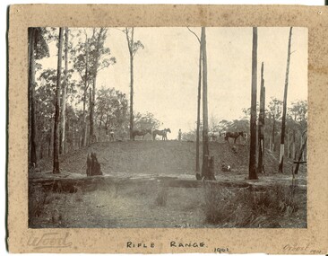
black and white photograph, Wood, 1901
This photograph appears to have been taken during the construction of the rifle range just north of the Orbost township. "The photo shows the range stop butt being formed by the scoops being pulled by the horses. It appears that the rear of the mound there is a wall of logs lining it, most likely to help with being eroded or washed away. They haven’t yet formed the mantlet and target machines." ( Info, from Victorian Rifle Association) The Orbost Rifle Club existed in the early 20th century. (There are records from 1900). It folded in the late 1970's.Target shooting is one of the oldest organised sports in Australia. Records date back to the British Marines at Sydney Cove in 1788. The Victorian Rifle Association (VRA) was formed in 1860. After Federation in 1901, rifle clubs came under army control, but in 1921 they were reconstituted as a civilian organisation, which they have remained ever since. After World War I a system of national training was embodied in the Defence Act and the rifle clubs reverted to their purely sporting role. A black / white photograph of four men and four horses standing an a soil bank with another man, a lady and a small girl at the base of the hill. It is in a clearing in forest. It appears to have a row of targets set at the edge of the bank. The photograph is mounted on a very mouldy cream coloured buff card.on front - "Wood" ; "Rifle Range - 1901" ; "Orbost 1901"sport-shooting orbost-rifle-range -
 Nillumbik Historical Society Incorporated
Book - Softcover book, A History of Tancks Corner - Yarrambat State School No. 2054 Centenary Year 1878-1978, 1978
Book 1. Softcover book with ochre yellow cover, brown text and highlights with 100 pages. Book 2. Softcover book with light blue cover with black text and highlights with 100 pages.tancks corner, yarrambat, yarrambat primary school, nillumbik -
 Carlton Football Club
Hardcover Book, Football Records H. & A. 1978, 1978
Hardcover book made in 1978 made to keep original copies of “The Football Record”. This book contains all Football Records relating to Carlton games for the home and away season of 1978. Captain: Alex Jesaulenko Coach: Ian Stewart / Serge Silvagni / Alex Jesaulenko Leading Goal-kicker: Rod Galt - 49 goals Best & Fairest: Trevor KeoghHardcover book, navy blue -
 Heidelberg Golf Club
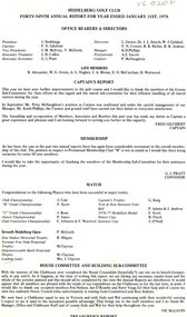
Document - Annual Report, Heidelberg Golf Club, Heidelberg Golf Club, Lower Plenty: Forty-seventh Annual Report, Year ended January 31st, 1978, 1978
Annual report of the Heidelberg Golf Club. Includes annual report, balance sheet and accounts to 31/01/1978Annual reports found in this collection begin in 1933-34. Numbering of annual reports commenced in 1973 with number 44.4 page document. Typed text. annual reports, financial reports -
 Orbost & District Historical Society
book, Smith, Margaret, The School Book - A Collection of School Photos from 1890
This book was compiled by Margaret Smith a long time member of Orbost Historical Society and Slab Hut manager/volunteer.This book documents the education history of the Orbost district and is a useful research tool.The School Book - a display book containing the history and photographs of schools in the Orbost district from 1890 to 1959. The texts and photographs are in plastic sleeves.slab-hut orbost-education education schools -
 Orbost & District Historical Society
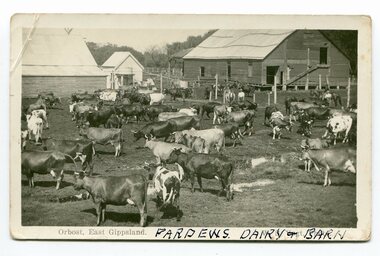
black and white photograph/ poscards, Vogt. W.S, C1890 - 1920
Edward James Pardew died in 26/9/1927 aged 92. He came to Orbost from New Zealand in 1886 and selected 720 acres of hill land in the Brodribb area. He was a member of the first Orbost Shire Council. His daughter had a fruit & meat shop in McLeod Street. He was an inaugural vestryman of St James Church of England. One of the most prominent farmers on the Snowy was John Gilbert, a large landowner. His breeding establishment was at Tullagoota, about two and a half kilometres down the river from Orbost.Dairying in the Orbost district was once a mainstay of the farming community. Today the properties are fewer and smaller.Two black / white photographs of dairy herds. 3188.1 - on front - printed -"ORBOST EAST GIPPSLAND"; hand-written - :PARDEWS DAIRY & BARN" 3188.2 - on front - printed - " W. S. VOGT"; hand-written - "DAIRY HERD TALLAGOOTA< ORBOST"dairying-orbost agriculture-orbost pardew-dairy tallagoota-dairy -
 Orbost & District Historical Society
account, 1910 - 1919
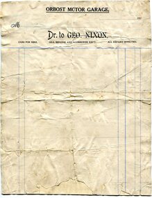
This account form was made for the Orbost Motor Garage owned by George Nixon. George Nixon (1862-1941) selected land in Bete Bolong in the 1890's. He married Emily Warren in 1889 in Orbost. He was a shire councillor. He was a prominent breeder of Clydesdales and after a serious fall off a horse walked with a walking stick and special boot for the rest of his life. He was well-known for his interest in cars, horse-racing and politics.He was married to Emily Warren in 1889 in Orbost. Mrs Nixon (Emily)was the first Red Cross president during WW1. They had ten children.both George and Emily are buried in the Orbost Cemetery. (ref:From White Knowle to Pumpkin Point by Hon Peter Nixon A.O.) This item is associated with a prominent Orbost family. George Nixon was the son of James and Alice Nixon. The Nixon families were among the earliest settlers on the Snowy River. It is an example of the early book-keeping of an Orbost business in the early 20th century.A white paper account form. It has black print, blue ruled lines and is unused. t the top is "Orbost Motor Garage" in black capital letters. document-book-keeping nixon-george -
 Orbost & District Historical Society
bottle, 1930's
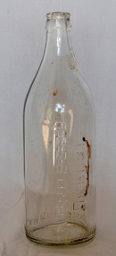
Dross Drossou established a cordial factory in Orbost in the 1930s. He sold his cordial manufacturing business to Phillips and Stone, a Bairnsdale company, in 1948. Glass bottles were refillable until the 1960s, creating a demand for their collection and onsale back to beverage manufacturers via ‘bottle merchants’. A deposit on the bottles was added to all sales as they left the factory. The returned bottles were washed and the old label removed. The inside was cleaned by pushing the bottle onto a revolving brush. The reusing of the bottles went on until the bottle was broken or the top became chipped.This bottle is an example of a product manufactured by a local industry which no longer exists.A clear glass soft drink bottle with a crown seal top. The bottle is seamed.A DROSSOU ORBOST This bottle is the property of A DROSSOU ORBOST Base - AGM F 860 Mbottle container drossou -
 Kew Historical Society Inc
Photograph - Kane's Bridge on the Yarra River, December 1934
In 1928 a footbridge was erected to link Kew with the public golf course across the Yarra. The total cost of construction came to 250 pounds and the bridge became known as Kane's Bridge. During the 1934 floods the bridge was washed downstream, and was subsequently rebuilt. The present form of the bridge resembles the earlier bridge which crossed from the Yarra Bend Asylum to Kew, further upstream. (VHD)Original, black and white positive of Kane's Bridge in December 1934, when the 'great flood' of the Yarra caused the bridge's destruction. Inscribed verso: "Kane's Bridge Yarra in flood Dec 1934"river yarra, yarra -- kew (vic.), kanes bridge, 1934 floods -
 Kew Historical Society Inc
Photograph - Yarra River in flood at the Willsmere Park, 1993
Willsmere Park is bounded by the the Yarra River, Green Acres Golf Club, Willow Grove and the Eastern Freeway. The land on which the park is now situated was bought by Thomas Wills at the Crown Land Sales of 1846 (Section 56). From the 1840s to the 1940s it was intensively farmed. The park is dominated by very large playing fields, while planting to the southern boundary was undertaken when the Eastern Freeway was built. It is only along the banks of the Yarra that there is any remnant native vegetation. Willsmere Park is of significance as an area of open land that remains from the flood plain that once dominated northern Kew. (Source: Kew Conservation Study, 1988)Original colour small format polaroid photograph of the Yarra River in flood at the Willsmere Park, taken on 16 September 1993."Yarra River at Willsmere Park Flooding 16.9.93"willsmere park, yarra river -- floods -- kew (vic.) -
 Kew Historical Society Inc
Photograph - Flooding in the Willsmere Park, 1993
Willsmere Park is bounded by the the Yarra River, Green Acres Golf Club, Willow Grove and the Eastern Freeway. The land on which the park is now situated was bought by Thomas Wills at the Crown Land Sales of 1846 (Section 56). From the 1840s to the 1940s it was intensively farmed. The park is dominated by very large playing fields, while planting to the southern boundary was undertaken when the Eastern Freeway was built. It is only along the banks of the Yarra that there is any remnant native vegetation. Willsmere Park is of significance as an area of open land that remains from the flood plain that once dominated northern Kew. (Source: Kew Conservation Study, 1988)Original colour small format polaroid photograph of flooding in the Willsmere Park, taken on 16 September 1993."Flooding of shared path from Willsmere Billabong 16.9.93"willsmere park, yarra river -- floods -- kew (vic.), kew billabong -
 Orbost & District Historical Society
black and white photograph, 1907
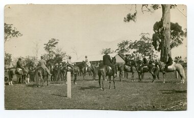
This photograph shows the show ring at the Orbost Annual Agricultural Show in 1907. The first meeting to form an Agricultural society in Orbost was convened by the then Orbost Progress Association and held in the Mechanics Hall on Saturday, 10th October 1891. Its first show was held on 3rd March 1904...on a site alongside the Bonang Road where the present Golf Club stands. It is currently held at the Recreation Reserve at Newmerella. (Ref: In Times Gone By-Deborah Hall) This item is associated with the Orbost Agricultural Society 's Annual Show which has been a major event in Orbost for over a century. Agricultural shows are an important part of cultural life in small country towns and the Orbost Show is an integral part of Orbost 's agricultural history. A black / white photograph of a large group of riders on horseback. They are in a paddock. In the background is a wooden building.on back - "Orbost Agric. Show Ring, 1907, Mrs A M Marshal East Bairnsdale"orbost-agricultural-show-event -
 Orbost & District Historical Society
black and white photograph, 1962
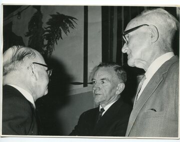
This photograph was taken at the Orbost High School Golden Jubilee celebrations in 1962. It shows Crs Truscott, Mr R. Osborne (1960-1963 Orbost High School Headmaster, and Mr George Cameron.Orbost High School / Orbost Secondary College has played a significant part in the education of senior students in the Orbost district . It is the sole senior educational institution. A black / white photograph of three men in suits.on back - hand-written -" Orbost H.S. Jubilee, 1962, Crs. Truscott, Osbourne & Geo. Cameron"education-orbost orbost-high-school -
Kew Historical Society Inc
Archive (Sub-series) - Subject File, Conservation Study (Kew) 1978, 1978
Various partiesReference, Research, InformationSecondary Values (KHS Imposed Order)Subject file containing a copy of the City of Kew’s Urban Renewal Proposal (13pp), dated June 1978. The proposal to the Urban Renewal Authority relates to those houses in Denmark Street, High Street South and Barkers Road, then known as ‘The Triangle’ (historically known as O’Shaughnessy’s Paddock. The report refers to the Kew Triangle Association.urban renewal -- kew (vic.), conservation studies -- kew (vic.), kew triangle associationurban renewal -- kew (vic.), conservation studies -- kew (vic.), kew triangle association -
 Orbost & District Historical Society
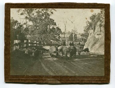
black and white photograph, C1900
Pigs were taken to Bairnsdale by coaxing them with maize thrown from a wagonette . From Bairnsdale they were freighted to market by train. The journey to Bairnsdale took about five days . This method of transport continued until the rail line to Orbost was opened in 1916.This photograph is a pictorial record of farming practices in the early 20th century.A black / white photograph on a brown buff card showing pigs being taken to market. The photograph shows the pigs close up with men on horseback behind them. The pigs are on a gravel road with a fence on one side and and the Orbost flats can be seen in the background.on back - "Pigs being driven from Orbost to Bairnsdale. M.Gilbert, Orbost"agriculture farming-orbost pigs -
 Greensborough Historical Society
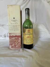
Memorabilia - Bottle, Greensborough Plaza Dental, Greensborough Centre opening 1978, 1978
Bottle of Stanley Leasingham 1976 Bin 62 Shiraz in Cardboard presentation box to celebrate the opening of Greensborough Centre November 13, 1978Gift bottle presented to a member of the local police to commemorate the opening of the Greensborough shopping complex.Cardboard Box with black writing and sepia image of early Greensborough containing green glass bottle with yellow label and black and red writing with logogreensborough plaza, commemorative items -
Ringwood and District Historical Society
Annual Report, Ringwood RSL Annual Report and Financial Statement 1978, 27-Feb-79
Copy provided by Derek F. Snowball, Secretary.Ringwood Sub-branch, Returned Services League Annual Report and Financial Statement for 1978. 40 pages. +Additional Keywords: Snowball, Derek F. -
 NMIT (Northern Melbourne Institute of TAFE)
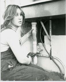
Photograph: CTC First female Plumbing Apprentice student in Victoria 1978
Black and white photograph of Lisa Howden, the first female Plumbing apprentice student in Victoria, at Collingwood Technical College 1978. (Scott p.78).collingwood technical college, students, plumbing course, nmit -
 Melbourne Tram Museum
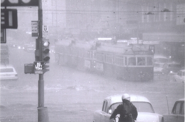
Photograph - Set of 9 Black & White Photograph/s, Ray Marsh, CBD Melbourne in 17 Feb. 1972 - floods, 1970's
... CBD Melbourne in 17 Feb. 1972 - floods ...Set of seven black and white photographs of Ray Marsh, of the flooding that occurred in the centre of the CBD Melbourne in 17 Feb. 1972. See Timeline History of Melbourne Trams - Barry George et al. .1 - 876 and two other trams, inbound, Bourke - Elizabeth at the height of the downpour. .2 - ditto, after the rain - looking east, with Dunklings in the view. .3 - W2, route 49, Little Collins and Swanston St looking west. Has a sign advertising Bush walking and sporting equipment above. .4 - W2 591 - north bound in Elizabeth St Essendon, route 49 looking south at corner of Collins St. Digital image of The Age article for the event supplied by Mal Rowe 4/12/12 by e-mail. 2nd copies of .2, .3 and .4 added ex donation of Keith Kings. .7 - Looking south from Bourke St / Elizabeth St. .8 - Bourke St at Elizabeth St with W6 976 and 992 in Bourke St on their way to Spencer St. .9 - Line up of trams in Bourke St (looking west) tailed by W6 999,. route 88. - two copies held. See Reg Item 5995 for photos of Flinders St at Market St. and 6099 for other photos.Details of the event written on the back of photos collected by Keith Kings and the Ray Marsh stamp in green ink with his address details.trams, tramways, melbourne, flooding, elizabeth st, bourke st, tram 876, tram 591, tram 976, tram 992, tram 999 -
 Orbost & District Historical Society
documents in folder, 1958-1964
These documents belonged to the Orbost Rifle Club.The Orbost Rifle Club existed in the early 20th century. (There are records from 1900). It folded in the late 1970's. It had a substantial membership.A light blue folder containing carbon copies of reports from the president of the Orbost Rifle Club from 1958-1964. The folder also contains correspondence from the Australian Rifle Association.orbost-rifle-club shooting documents -
 Orbost & District Historical Society
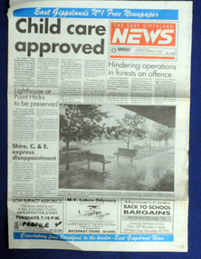
newspaper article, January 31 1991
On 24 January 1991 a severe hailstorm occurred in Orbost. The Insurance Council of Australia estimated the 1991 damage at $12 million.This is a contemporary record of a significant event in Orbost.The front and back page of The East Gippsland News dated Thursday January 1991. The main article is a photograph of the hailstorm damage to Nicholson Street in Orbost.hailstorm-orbost east-gippsland-news newspaper-article -
 Federation University Historical Collection
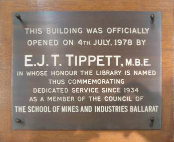
Sign - Plaque, E.J.T. Tippett Library Plaque, 1978, 1978
Metal plaque with white writing.This building was officially opened on 4th July, 1978 by E.J.T. Tippett, M.B.E. in whose honour the library is named thus commemorating dedicated serviced since 1934 as a member of the Council of The School of Mines and INdustries Ballaratballarat school of mines, library, ballarat school of mines library, e.j.t. tippett library, tipppet library, e.j. tippett -
 Orbost & District Historical Society
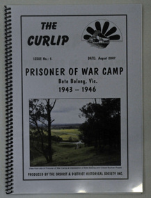
book, The Curlip No : 5, August 2007
This book was compiled after an Orbost Historical Society bus trip to the site of the Prisoner of War Camp at Bete Bolong.This is a locally produced history book which is a useful reference for research into the history of Orbost.A 26 pp spiral bound book with a pale grey cover titled THE CURLIP NO 5, PRISONER OF WAR CAMP, Bete Bolong, Vic. 1943-1946. On the front cover in the top right hand corner is black sketch of a large paddle wheel with the P.S. Curlip in front of it. There is a coloured photograph of the view from the site of the P.O.W. Camp at the intersection of Bete Bolong and Buchan Roads.orbost-history bete-bolong ww11 prisoner-of-war-camp italian-prisoners