Showing 22262 items
matching parkes
-
 Kew Historical Society Inc
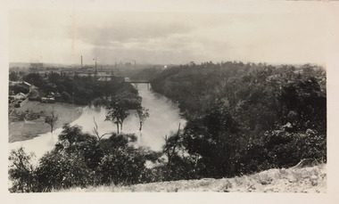
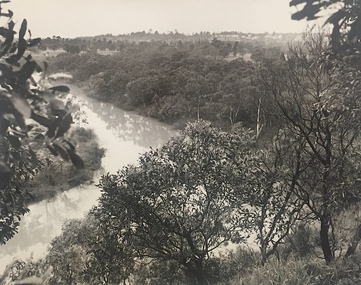
Photograph - Yarra River, Studley Park, 1924
Henry Beater Christian (1886-1962) , was a descendant of one of the earliest settler families in Kew. Employed at the Kew Asylum as a 'public servant', he was a skilled amateur photographer, photographing numerous scenes in Kew and on his travels around Victoria. The majority of his photographs date from 1916 to 1929. His finest photographs are housed in two photograph albums. Digital copy of a photograph from page 7 of the 47-page photograph album containing 261 gelatinous silver images, loaned by Diane Washfold with permission given to digitise and hold a copy in our collection. This photograph was taken during a flood year when the Yarra encroached on the grounds of the Abbotsford Convent. In the distance, the Johnston Street Bridge separates the viewer from the industrialised landscape of Fairfield."Studley Park / Kew"henry beater christian (1886-1962), landscape photography, kew (vic.) — yarra river, christian-washfold collection, photograph albums, fairfield, kew, johnston street bridge, studley park -
 Kew Historical Society Inc
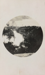
Photograph - Yarra River, Studley Park, 1924
Henry Beater Christian (1886-1962) , was a descendant of one of the earliest settler families in Kew. Employed at the Kew Asylum as a 'public servant', he was a skilled amateur photographer, photographing numerous scenes in Kew and on his travels around Victoria. The majority of his photographs date from 1916 to 1929. His finest photographs are housed in two photograph albums. Digital copy of a photograph from page 7 of the 47-page photograph album containing 261 gelatinous silver images, loaned by Diane Washfold with permission given to digitise and hold a copy in our collection. This photograph was taken during a flood year, perhaps 1923, when the Yarra encroached on the grounds of the Abbotsford Convent. In the distance, the Johnston Street Bridge separates the viewer from the industrialised landscape of Fairfield. In developing the photo, Henry Christian employed a circular frame to artistically focus the view. He empkloyed this technique for what he may have viewed as his best photographs. "Studley Park / Kew"henry beater christian (1886-1962), landscape photography, kew (vic.) — yarra river, christian-washfold collection, photograph albums, fairfield, kew, johnston street bridge, studley park -
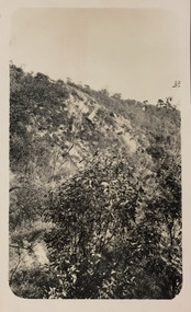
 Kew Historical Society Inc
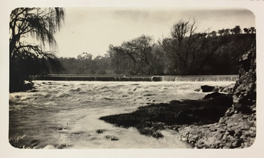
Photograph - Dight's Falls, 1924
Henry Beater Christian (1886-1962) , was a descendant of one of the earliest settler families in Kew. Employed at the Kew Asylum as a 'public servant', he was a skilled amateur photographer, photographing numerous scenes in Kew and on his travels around Victoria. The majority of his photographs date from 1916 to 1929. His finest photographs are housed in two photograph albums. Digital copy of a photograph from page 9 of the 47-page photograph album containing 261 gelatinous silver images, loaned by Diane Washfold with permission given to digitise and hold a copy in our collection. The point-of-view selected by the photographer, Henry Christian, is of Dight's Falls on the Yarra River from the Kew side. Dight's Falls separates the saline and fresh water sections of the river. "Studley Park / Kew"henry beater christian (1886-1962), landscape photography, kew (vic.) — yarra river, christian-washfold collection, photograph albums, yarra river -- studley park (vic.), dight's falls -
 Kew Historical Society Inc
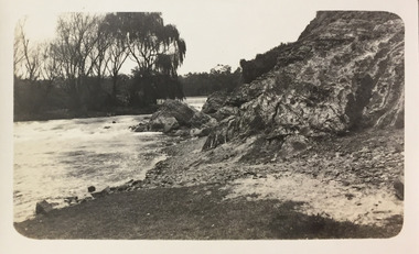
Photograph - Yarra River below Dight's Falls, 1924
Henry Beater Christian (1886-1962) , was a descendant of one of the earliest settler families in Kew. Employed at the Kew Asylum as a 'public servant', he was a skilled amateur photographer, photographing numerous scenes in Kew and on his travels around Victoria. The majority of his photographs date from 1916 to 1929. His finest photographs are housed in two photograph albums. Digital copy of a photograph from page 9 of the 47-page photograph album containing 261 gelatinous silver images, loaned by Diane Washfold with permission given to digitise and hold a copy in our collection. The point-of-view selected by the photographer, Henry Christian, is below Dight's Falls on the Yarra River from the Kew side. Dight's Falls separates the saline and fresh water sections of the river. "Studley Park / Kew"henry beater christian (1886-1962), landscape photography, kew (vic.) — yarra river, christian-washfold collection, photograph albums, yarra river -- studley park (vic.), dight's falls -
 Kew Historical Society Inc
Photograph - Yarra River, Studley Park, 1924
Henry Beater Christian (1886-1962) , was a descendant of one of the earliest settler families in Kew. Employed at the Kew Asylum as a 'public servant', he was a skilled amateur photographer, photographing numerous scenes in Kew and on his travels around Victoria. The majority of his photographs date from 1916 to 1929. His finest photographs are housed in two photograph albums. Digital copy of a photograph from page 9 of the 47-page photograph album containing 261 gelatinous silver images, loaned by Diane Washfold with permission given to digitise and hold a copy in our collection. The point-of-view selected by the photographer, Henry Christian, is from the Yarra River at Dight's Falls looking up at the cliffs at Galatea Point. "Studley Park / Kew"henry beater christian (1886-1962), landscape photography, kew (vic.) — yarra river, christian-washfold collection, photograph albums, yarra river -- studley park (vic.), dight's falls, galatea point -
 University of Melbourne, Burnley Campus Archives
Photograph, 23, 1929
Richmond Park 1929.richmond park, 1929 -
University of Melbourne, Burnley Campus Archives
Photograph, 25, 1929
The Park Oct 1929.parks, garden views -
 Kew Historical Society Inc
Photograph, J E & B L Rogers, View of Yarra from Cliffs, Studley Park, 1958
This work forms part of the collection assembled by the historian Dorothy Rogers, that was donated to the Kew Historical Society by her son John Rogers in 2015. The manuscripts, photographs, maps, and documents were sourced by her from both family and local collections or produced as references for her print publications. Many were directly used by Rogers in writing ‘Lovely Old Homes of Kew’ (1961) and 'A History of Kew' (1973), or the numerous articles on local history that she produced for suburban newspapers. Most of the photographs in the collection include detailed annotations in her hand.The Rogers Collection provides a comprehensive insight into the working habits of a historian in the 1960s and 1970s. Together it forms the largest privately-donated collection within the archives of the Kew Historical Society.Back and white photograph of the Yarra River at Kew. In the distance the towers of the Kew Asylum are visible."View of Yarra from Cliffs, Studley Park" / "Studley Park" / "Jim's" / "58"yarra river -- kew (vic), landscape photography -
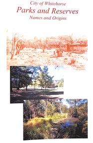 Ringwood and District Historical Society
Book, Parks & Reserves - City of Whitehorse
Parks & Reserves - City of Whitehorse Parks & Reserves Names & Origins -
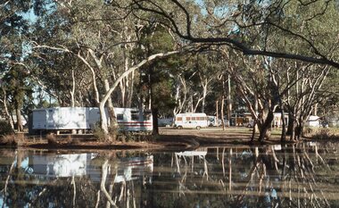 Stawell Historical Society Inc
Slide, Ian McCann, View Across the lake at the Caravan Park
Caravan Park with vans across the lake at Stawell Caravan Parkbuildings, caravan park -
 Melbourne Legacy
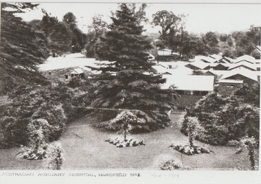
Photograph, Harefield UK, 1919
Copies of photos of the No 1 Australian Auxiliary Hospital set up in the ground of Harefield Park during the first World War. They were wooden huts. Also the graves of the deceased soldiers in the Australian Military Cemetery in 1919 in Harefield's St Mary's churchyard. Plus two photos of the Mansion at Harefield one in 1917 and one from 1927. Harefield Park was owned by Australian couple, Letitia Billyard-Leake (born Letitia Leake) and her husband Charles Billyard and their 4 children. The family donated their property, Harefield Park, to the Australian Government for use as an Australian-run hospital. The family moved off the property and lived nearby to help run the hospital. Letitia and her daughter, also named Letitia, ran the canteen while Charles Billyard organised activities and was a hospital board member. (from research from Carol Grbich and John Berger). During World War 1 the Australian Auxiliary Hospital No.1 was stationed at Harefield Park in Harefield, UxBridge, Middlesex UK. 111 Australian soldiers and one nurse from the hospital are buried at St Mary's Church, Harefield. This became an Australian Military Cemetery with individual headstones and an obelisk and arch. The headstones which are of a scroll design unique amongst Commonwealth War Graves Commission cemeteries were chosen by the staff and patients at the hospital. The arch was erected by the CWGC. Anzac Day services are held there and the local school became involved with the headmaster, Mr Jefferies, bringing the school children to lay flowers on every grave and attend the service on Anzac Day. This started in 1921 and has continued until at least 2021. One school child who attended was Mr Alf Young, he made contact with Legacy in the 1990s and sent photos of the Anzac Day Services and the cemetery. Legacy responded by sending Australian flags for the school children and also Legatee John Cohen met with Mr Young when in London. Melbourne Legacy staff member Susie Howard also visited Mr Young and the cemetery in 1995. Mr Young provided historical photos and information of the area to Legacy. He was featured in the widows' newsletter The Answer many times and his death was announced in The Answer in April 1997, he was 85. Many of the photos he provided were labelled as coming from Mr R G Neil, Photographic historian from Harefield. He holds copyright over those photos.A record that Legacy helped support remembrance of Anzac Day and World War 1 soldiers buried in the UK.Black and white photos x 4 of the Harefield Hospital and area from 1917 to 1927.02067.1 Printed on front 'Australian Auxiliary Hospital, Harefield No 1. 1914-1918'. Handwritten on reverse 'Harefield Park 1917'. Handwritten label 'Hospital as it was 1916-1918'. 02067.2 Handwritten on the reverse 'Part of the old Australian cemetery 1919'. Handwritten label 'The grave on the left "Private Wake" was the first grave in the cemetery'. 02067.3 Printed on the front 'The Lake, Australian Hospital Harefield Park, Mdx.' Handwritten on reverse 'Harefield Park 1917'. Handwritten label 'The lake in front of the mansion 1917'. 02067.4 Printed on the front 'Harefield Park' and 'Coles Watford'. Handwritten on reverse 'The Mansion, 1927 Harefield Park'. All four have a sticker of Mr RG Neil, the photograph historian that provided the reprint.cemetery, harefield, alf young, memorial, wreath laying ceremony, hospitals -
 Whitehorse Historical Society Inc.
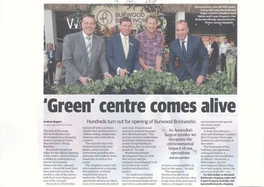
Article, 'Green' Centre Comes Alive, 09/12/2019
Burwood Brickworks has been officially opened as a living building.Burwood Brickworks has been officially opened as a living building with a 2000 sq. m. rooftop farm and 250 trees to cover the northern side of the centre & fruit trees lining each row of the car park.Burwood Brickworks has been officially opened as a living building. brickworks, shopping centre, environment, trees -
 Lakes Entrance Historical Society
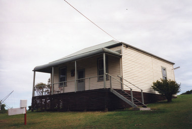
Photograph - Housing, 1999 c
Original home of the Charles Cross family.The property became the first Camp Park at Lake Tyers Beach of the Methodist, now Uniting Church.A colour photograph of a timber dwelling with corrugated iron hip roof. Eight steps lead up to a bullnose veranda across the front and sash windows. Situated at the Uniting Church Camp Park, Lake Tyers Beach, Victoria.houses, local history -
 Federation University Historical Collection
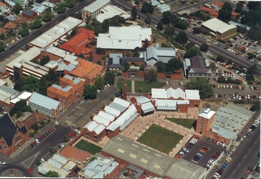
Photograph - Photograph - Colour, Aerial Views of Sites Relating to the University of Ballarat, c1998
The Ballarat Technology Park is associated with Federation University Australia. Five colour aerial photographs of sites associated with Federation University Australia. .1 & .2) Aerial views of the State Data Centre, Ballarat Technology Park .3) Aerial view of Mt Helen Campus, c1990 .4 and .5) Aerial View of Ballarat School of Mines Campus, 1998ballarat technology park, state region data centre, ballarat aerial view, ballarat school of mines aerial, aerial, brewery building, ballarat uniting church, albert street -
 Kew Historical Society Inc
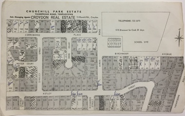
Plan - Subdivision Plan, Churchill Park Estate, Templestowe
Historic subdivision plan of the Churchill Park Estate in Templestowe.Undated subdivision plan advertising the Churchill Park Estate inTemplestowe. Streets identified in the plan include: Corroboree Place, Astley Street, Jeffrey Street, Airds Road, Dove Court, Potter Court, Thompsons Road, Richards Street, and Birchwood Avenue. This record includes a copy of the price list.Annotations in ink on the plan by agentsubdivision plans - templestowe (vic), churchill park estate - templestowe (vic) -
 Cheese World Museum
Photograph, Tooram Park homestead c1915, early 20th century
The Percy Uebergang family lived at Tooram Park, Allansford from 1912 until 1992. Percy and Myrtle Uebergang's children were twins, Ray and Joyce born in 1926 who lived at Tooram Park until their deaths, Ray in 1986 and Joyce in 1992. Neither Ray nor Joyce married and following the death of her brother Joyce set up the Ray and Joyce Uebergang Foundation which supports the local community. This photograph is part of the collection of items given into the care of the Cheese World Museum. The Uebergang family purchased Tooram Park in 1912. It was part of the original Tooram run which was taken up in 1839/40 by John McMahon Allan. Allan held the property until 1860 after which it passed through several owners including John Orlebar, Thomas McLeod Palmer, Owen family. Tooram was famous for the cheese from its large dairy herd. The herd was hand-milked. Palmer employed Indian labour to undertake this task. In 1883 Palmer was charged with the manslaughter of an Indian worker but was acquitted. This case was extensively reported in the Warrnambool Standard. The Standard also featured a number of articles about Tooram [22 June 1882, 17 March 1883 to 15 May 1993, 30 October 1886, 22 October 1897, 11 May 1926, 8 June 1931]. The property remained in the Uebergang family until after Joyce's death in 1992. Tooram is significant as it was one of the earliest runs taken up in the Warrnambool area. It was divided up following its sale in 1897. Tooram cheese was renowned. This photograph is significant as it shows Tooram Park homestead in its earlier days with the prolific timber decoration which was later removed.Black & white photograph on a cardboard mount showing Tooram Park homestead. The house has a white picket fence. A drain is in the foreground and is serviced by a stone culvert is in the right foreground. Two cars are parked in front of the house. The house walls are painted a dark colour. The verandah roof is striped dark and white. The timber decoration on the verandah, barge board and gable is white.allansford, tooram, tooram park, uebergang, john orlebar, john mcmahon allan, thomas mcleod palmer, owen family, indian labour, court cases, dairying, dairying, warrnambool standard -
 Whitehorse Historical Society Inc.
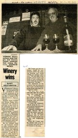
Article, Winery wins, 1992
... parkes ...Vermont winery has won an appeal in the Administrative Appeals Tribunal to open a 30 seat restaurant.Vermont winery has won an appeal in the Administrative Appeals Tribunal to open a 30 seat restaurant.Vermont winery has won an appeal in the Administrative Appeals Tribunal to open a 30 seat restaurant.wineries, vermont winery, cooper, scott, parkes, dennis -
 Darebin Parklands Association
Horses in Rockbeare Park 1970s, Laurie Course, 1973-1980
Rockbeare Park was leased by Heidelberg Shire to McLosky's riding school for agistment of horses until around 1974.B&W photograph showing horses grazing in the Park. This item and all other Darebin Parklands Association archival material is now held by State Library Victoria (Accession No: YMS 13746). Please contact State Library Victoria if access is required. -
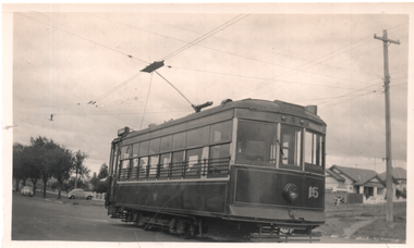 Ballarat Tramway Museum
Photograph - Geelong 15 at Eastern Park, Ken Winney, May 1947
The photo shows Geelong Birney tram 15 at the Eastern Park terminus. Note the large overhead pan to assist crew in locating the trolley pole, particularly at night. Photo by Ken Winney May 1947.Yields information about the Geelong Eastern Park terminus and tram 15.Black and white photograph with typed details on rear.Typed on rear "SEC system Geelong, Birney safety car No. 15 at Eastern Park terminus, May 1947". Ken Magor stamp and "K Winney" tramways, trams, geelong, eastern park, tram 15 -
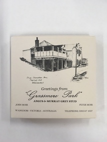 Warrnambool and District Historical Society Inc.
Souvenir, Coasters Grassmere Park x 11, Late 20th C
Grassmere Park is a property on the outskirts of Warrnambool at Wangoom. The scenes depicted are of historic buildings such as Star of the West in Port Fairy, the Koroit Post Office and various buildings at Flagstaff Hill in Warrnambool. The drawings are all signed by John Moir a local artist.Social significance. A common item with local views with which local people would be familiar.A set of 11 square cream card coasters with black pen drawings of local scenes with text underneath the drawings.Greetings from Grassmere Park Angus and Murray Grey Stud. John Moir Peter Moir. Wangoom Victoria Australia telephone 055)671037warrnambool, grassmere park, wangoom, -
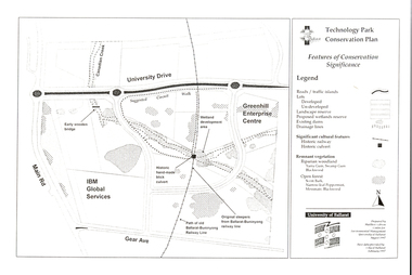 Federation University Historical Collection
Document - Plan, Mathew Gibson, Centre for Environmental Management, Ballarat Technology Park Conservation Plan, 1997, 1997
The Ballarat Technology Park is on the Mount Helen Campus.A4 photocopy of a plan of the Ballarat Technology Park showing features of conservation significance. The plan includes the Canadian Creek, an historic hand-made brick culvert, Canadian Wetland Development, early wooden bridge, old path of the Ballarat-Buninyong Railway line, Greenhill Enterprise Centre and IBM Global Services.ballarat technology park, greenhill enterprise centre, ibm global enterprises, ballarat-buninyong railway line, canadian wetlands, brick railway culvert, canadian creek, riparian woodland, yarra gum, swamp gum, blackwood, remnant vegetation, scent bark, narrow-leaf peppermint, messmate, centre for environmental management, mount helen campus -
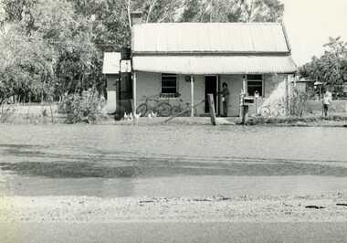 Charlton Golden Grains Museum Inc
Photograph, Charlton Tribune, 1973 February Flood, Feb 1973
Feb 1973 flood Charlton, Victoria. Old Ive's house with floodwater to front fence on the Calder Highway opposite Charlton Park Gates. Mrs Gloria Jordan.B/W Photograph of February 1973 flood. Old Ive's house with floodwater to front fence on Calder Highway opposite Charlton Park gates. Photo used in Charlton Tribune on 09/07/1973 P4.flood, charlton, calder highway, local brick -
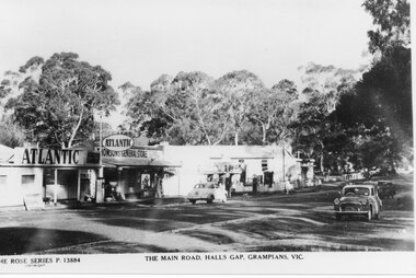 Halls Gap & Grampians Historical Society
Postcard - B/W, C 1950s
Thomson's and Taylor's shops with the Halls Gap Hall further along the road. A number of 1950's vintage cars are parked along the main road. No. 13884 in the Rose Series of postcards.A strip of shops along a bitumen road. One shop is a garage with Atlantic signs and another has a sign that reads "Thomson's General Store". There are several cars parked along the road and eucalyptus trees in the background.buildings, shops -
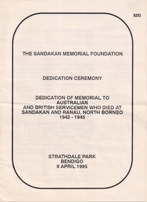 Bendigo Military Museum
Pamphlet - SANDAKAN MEMORIAL 1995, C. 1995
This service was to dedicate a Memorial to Australian & British Servicemen who died at Sandakan and Ranau, North Borneo 1942 - 1945. It was unveiled at Strathdale Park Bendigo on 9.4.1995. The Official Party were; Mr Peter Ross Edwards AM, Chief Commissioner The City of Greater Bendigo, Mr J.S. Millner AM, Chairman The Sandakan Memorial Foundation. The Requiem was read by Father John Brendan Rogers OFM. Unveiling the Memorial by, Mr Peter Ross Edwards AM. Dedication of the Memorial by; Father John Brendan Rogers OFM, Chaplain 8th Division Sandakan and Kuching, Chaplain Gary Kenney, Australian Army. Laying of the wreaths, Wreath Marshalls supplied by Bendigo RSL Sub Branch, Australian Army Band Melbourne. The ODE was read by; President Bendigo RSL Mr Cliff Clohesy. The Catalflaque Party was supplied by; Army School of Survey Regiment Bendigo.Pamphlet off white colour, A4 folded making 8 pages total, all print in black, one staple central holding together.On the front, "The Sandakan Memorial Foundation, Strathdale Park Bendigo 9 April 1995"brsl, smirsl, sandakan, strathdale -
Port Melbourne Historical & Preservation Society
Photograph - Friends of the Park float, Port Melbourne Festival, Pat Grainger, Feb 1989
This float was created by members of Friends of the Park, a group formed in 1987 against government proposals to turn the railway and reservation into a grand boulevard to service the proposed Sandridge City 'Bayside' development. Members worked for months to make the decorations, added to a trailer. During the festival procession sausages were BBQ'd on the trailer and handed out to the crowd. On arrival at Murphy's Reserve all floats were put out of sight, and few saw the results of their efforts.One of 16 photos of Friends of the Park float for the February 1989 Port Melbourne Festival: Float construction at 88 Ingles Stcelebrations fetes and exhibitions, public action campaigns, town planning - proposals shelved - bayside, anne callaghan, gary way, friends of the park, sandridge city development co pty ltd, scdc, port melbourne festival -
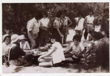 Ringwood and District Historical Society
Photograph, Heathmont Guides - Guide camp -Clifford Park,Wonga Park
Black and white photograph showing guides sitting and standing around low table outdoors."Written on back of photo" Guide camp-Clifford Park,Wonga Park. Heathmont Guides -
University of Melbourne, Burnley Campus Archives
Document, Lex Neiboer, 2012
1. Brochure "Melbourne Parks & Gardens through the Magic Lantern 2. About the Park (Wilson Botanic Park, Berwick). 2 itemslex neiboer, melbourne, parks, gardens, wilson botanic park, berwick -
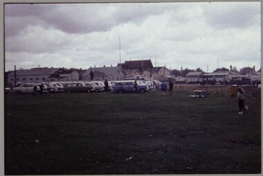 Melbourne Legacy
Slide, Operation Float 1963, 1963
A colour slide of many cars parked together. They would have been the transport to bring children together for Operation Float in 1963. Operation Float was an event run by Melbourne Legacy to take Junior legatees on an outing. It could have been to naval boats such as HMAS Cerberus or to a Yacht club. It gave the junior legatees the opportunity to see a naval boat in action, spend time on the water or try sailing. Part of a set of slides that are printed on Ektachrome and discoloured to a pink tinge. Was with many other slides taken in the 1950s and 1960s. The slides have been photographed to make digital images and moved to archive quality sleeves. In many cases the original images were not well focussed and the digital image the best available.A record of outings being organised for children.Colour slide of many cars parked in plastic mount that is white on the front and navy blue on the reverse.Handwritten in black pen ' Operation Float 1963'.operation float, junior legatee outings -
 Rutherglen Historical Society
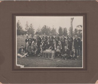
Photograph - Image, 1923 (Approximate)
Black and white photograph of the Rutherglen Brass Band taken in the Memorial Park. Mounted on cardboard.Written on back of mount: "Rutherglen Brass Band Approx 1923. Photo taken in Rutherglen Park. Back row L to R - Bernie Newett, Stanley Stanton, Steven James Herrin, (?) , Tom Walsh, Leslie Jones, Fred Cooper, Alex Johnson, William Collier, Albert Bundy. Middle row - Victor Leroy, Jack Blowers, Alec Hayes, Arthur Warren (Band Master), Max Barber, Sterling Warren, Leopold Herrin. Bottom row - Harold Davies, (?) , Ron Hossack, (?) , Edward Ray, Richard Warren. The Committee for the Rutherglen Brass Band raised money for building the Rotunda."brass band, rutherglen memorial park, bernie newett, stanley stanton, stephen herrin, tom walsh, leslie jones, fred cooper, alec johnson, william collier, albert bundy, victor leroy, jack blowers, alec hayes, arthur warren, max barber, sterling warren, leopold herrin, harold davies, ron hossack, edward ray, richard warren -
 Stawell Historical Society Inc
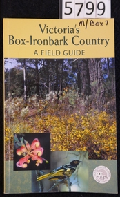
Book, Malcolm & Jane Caulder, Victoria’s Box Iron Bark Country - A Field Guide, 2002
This is the definitive guide to the Box-Ironbark forests of Central and North-East Victoria First published in 1994 as The Forgotten Forests. By the Victorian National Parks Association Ltd.Cardboard cover with yellow band at top containing Title in green print, below which are 3 colour photographs one showing bushland, one showing closeup of a flower, the other showing a bird. Logo for the Victorian National ParksVictoria's Box-Ironbark Country. A Field Guide Autographed by Ian McCann (Photographer)stawell