Showing 40550 items matching "roads and streets"
-
 Canterbury History Group
Photograph - Street view of the demolition of the Uniting Church on the corner of Canterbury Road and Hopetoun Ave., Canterbury, Jan Pigot, 1994
Coloured photograph of Street view of the demolition of the Uniting Church on the corner of Canterbury Road and Hopetoun Ave., Canterburycanterbury, canterbury road, churches -
Canterbury History Group
Photograph - Street view of the demolition of the Uniting Church on the corner of Canterbury Road and Hopetoun Ave. Canterbury, Jan Pigot, 1994
Coloured photograph of the street view of the demolition of the Uniting Church on the corner of Canterbury Road and Hopetoun Ave. Canterburycanterbury, canterbury road, churches -
Canterbury History Group
Photograph - Corner view of shops south east facing shop at Maling Road and Bryson Street, Jan Pigot, 27/03/1993 12:00:00 AM
Coloured photograph of the south eastern facing corner of Maling Road and Bryson Street shops entitled The Blockcanterbury, maling road, shops, telegraph poles, victorian architecture, trees -
 University of Melbourne, Burnley Campus Archives
Photograph - Black and white print, A.W. Jessep, Entrance Road From the Plant Research laboratory to Swan Street, December 1932
Black and white photograph. Road winding from the Plant Research Laboratory towards the Swan Street entrance. "Plant Research Laboratory from front door looking towards the Entrance Gates. Dec 1932. A.W. Jessep."plant research laboratory, a.w. jessep, entrance, swan street, plant science laboratory -
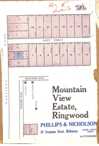 Ringwood and District Historical Society
Map, Partially Trimmed Copy of Mountain View Estate Subdivision Advertisement, Ringwood, Vic. - (Undated, circa 1930s)
Clipped subdivision map on cardboard backing. 22 residential allotments on Daisy Street and Wantirna Road, Ringwood.Auctioneers - Phillips & Nicholson, 59 Swanston Street, Melbourne. Phone Central 10907. -
 Kew Historical Society Inc
Plan - Subdivision Plan, Lodged Plan No.6518, 1920-1940
The Kew Historical Society collection includes almost 100 subdivision plans pertaining to suburbs of the City of Melbourne. Most of these are of Kew, Kew East or Studley Park, although a smaller number are plans of Camberwell, Deepdene, Balwyn and Hawthorn. It is believed that the majority of the plans were gifted to the Society by persons connected with the real estate firm - J. R. Mathers and McMillan, 136 Cotham Road, Kew. The Plans in the collection are rarely in pristine form, being working plans on which the agent would write notes and record lots sold and the prices of these. The subdivision plans are historically significant examples of the growth of urban Melbourne from the beginning of the 20th Century up until the 1980s. A number of the plans are double-sided and often include a photograph on the reverse. Reconciling this hand-drawn subdivision plan with a modern map of the area is initially a challenge due to a change of street names. Argyle Road in the centre of the subdivision was to be renamed Deepdene Road, and the street named Deepdene Road on the plan was to become Deepdene Place. Of interest is the nursery on the corner of Argyle and Whitehorse Roads. During this period there were a number of nurseries servicing the Kew and Balwyn areas. The subdivision was essentially of the land formerly occupied by the house 'Deepdene'.subdivision plans - balwyn, deepdene, whitehorse road -- deepdene (vic.), deepdene road -- deepdene (vic.), burke road -- deepdene (vic.) -
 Surrey Hills Historical Society Collection
Photograph, Churchill Street, Mont Albert and Mont Albert Station, looking towards Hamilton Street, 1919, 1919
The railway extended through to Mont Albert in 1882, but it wasn't until 1890 that a station was built with funds raised by a syndicate of local landowners.The buildings on the south side of the railway were built in 1910-1911 in the Arts and Crafts style by architect, K W Hardy. The land occupied by the Hamilton Street shops was subdivided in the 1880s and the first purpose-built shop was 'Pope and Moran, Grocers'. This shop later became Tom Morris' Grocery. By 1930 shops stretched along both sides of Hamilton Street and part way along Churchill Street. The donor, the late Norman Carter held a significant collection of photos taken around Mont Albert and Surrey Hills, in particular subjects related to the Church of England.Black and white photo taken from the centre of the road in Churchill Street, Mont Albert. Mont Albert station is on the RHS fenced off by a post and rail fence. Shops can be seen at the intersection of Hamilton and Churchill Streets. There do not appear to be any shops in Churchill Street. There are newly planted street trees within paling guards on the LHS. There does not appear to be any curb and channelling at the side of the road.Rear in blue biro in Jocelyn Hall's handwriting "Mont Albert Station 1919".mont albert station, railways, hamilton street, churchill street, shops, arts and crafts style, norman carter -
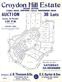 Ringwood and District Historical Society
Flyer, Land Auction Sale Advertisement, Croydon Hill Estate, Croydon, Victoria - 1959
Single sided land auction sale advertisement for 38 residential allotments - Croydon Hill Estate (Second Section) Yarra Road, Croydon - corner Whitehorse Road. Auction Saturday, 5th December, and corresponding newspaper advertisement - Ringwood Mail, Thursday, November 26, 1959.Subdivision map includes Richardson Road, Yarra Road, Whitehorse Road, Alice Street, Hull Street (later Mulawa Stret). Auctioneers in Conjunction: J.B. Thomson & Co., Station Entrance, Box Hill, (Telephone) WX 1862, WX 7356, and at Nunawading, WU 1968, WU 3452, and C.E. Carter & Son, 126 Whitehorse Road, Ringwood. WU 6024. -
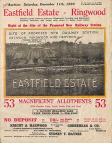 Ringwood and District Historical Society
Flyer, Subdivisional Land Auction Sale Brochure, Eastfield Estate, Ringwood, Vic. - 1920
Bi-folded double sided land advertisement for subdivision auction on Saturday, December 11th, 1920, for Eastfield Estate with location map and summary of local facilities and services.Subdivision includes Croydon South streets - Eastfield Road, Long View Road, The Mount, and Pleasant Rise. Local Agent - Godbehear & Co, Phone Ringwood 49. -
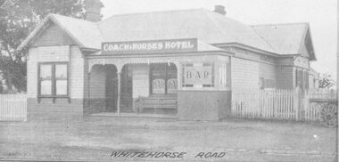 Ringwood and District Historical Society
Photograph, Coach and Horses Hotel, Whitehorse Road, Ringwood. 1924
Appears to be reproduction of newspaper photograph. South Side of highway.Written below one photograph, "Photo of Coach and Horses Hotel, corner of White Horse Road and Madden Street. Enter Estate at Madden Street". 1924. -
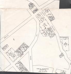 Bendigo Historical Society Inc.
Map - VICTORIA HILL - MAP - HAPPY VALLEY RD - DARE ST
Small map showing some blocks of land in the Happy Valley Road, Dare Street and Wells Streets area. Three of the blocks are in the name of Rae. Notes by Albert Richardson.map, bendigo, victoria hill, victoria hill, victoria hill - map - happy valley road - dare street, w rae, j rae -
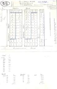 Ringwood and District Historical Society
Plan, Plan of Subdivision No.11498 with handwritten costing notations - East Ringwood Central Estate c.1948
Two handwritten pages showing layout of Subdivision no 11498 with surveyor notations including property sizes and road construction cost calculations. Drainage easement 6 feet wide shaded blue.Plan of Subdivision No. 11498, Part of Crown Allotment 27, Parish of Ringwood, County of Mornington, (Certificate of Title Vol 5120 Fol 1023945). Owner Mr Vogel. Subdivision includes Knaith Road, Northwood Street, Langley Street, Bondi Street, and Government Road (later Alexandra Road), Ringwood East. G. Parsons & Sons, Licensed Surveyors, 389 Flinders Lane (Melbourne). -
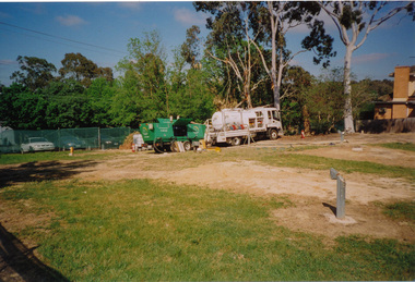
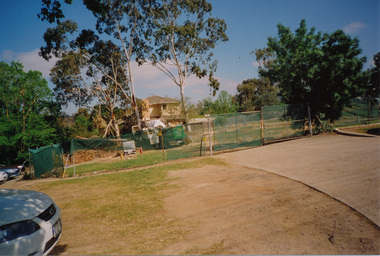
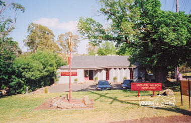
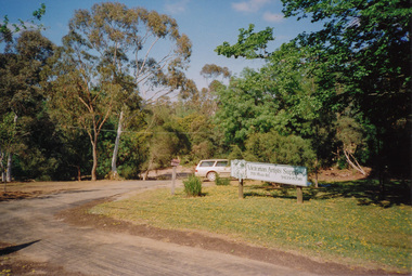 Eltham District Historical Society Inc
Photograph, Commercial businesses at the corner of Brougham Street and Main Road, Eltham, Oct 2008, 2008
Four colour photographs; two showing site works at the corner of Brougham Street and Main Road, one showing Michael Wilson Jeweller at 725 Main Road and one showing Victorian Artists Supplies at 715 Main Road, Elthameltham, brougham street, main road, michael wislon jeweler, victorian artists supplies -
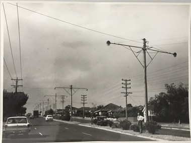
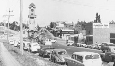
 Whitehorse Historical Society Inc.
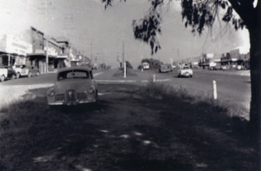
Photograph, Mitcham - 1952, c1952
Sent to a parishioner at Christ Church Mitcham, by Phyllis Grant who lived at the Migrant Hostel in Mitcham in 1952-54, where her husband did development work under the P.M.G.Black and white photograph of Mitcham shopping centre looking east from Edward Street - although it was only a two lane road at Mitcham, Whitehorse Road had its service roads well developed. Note the early Holden in the foregroundwhitehorse road, mitcham, holden, grant, phyllis -
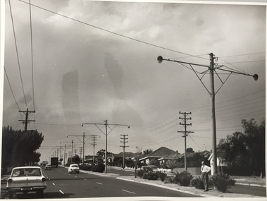
 Whitehorse Historical Society Inc.
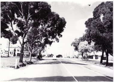
Photograph, Whitehorse Road Mitcham
Black and white photo of Whitehorse Road, Mitcham looking east. Approaching Mitcham Road from Nunawading (Tunstall) in Whitehorse Road. Note local blacksmith with Velvet Soap sign on west wall opposite Church of England in Edward Street.whitehorse road, mitcham -
 Ringwood and District Historical Society
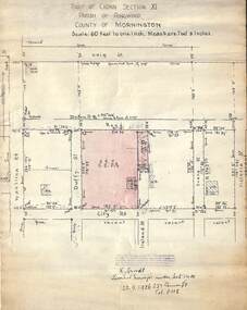
Document, 1926 Land Survey drawing of the area surrounding 1-5 City Road, Ringwood
Drawing on parchmentHand-drawn survey of what is now 1-5 City Road, Ringwood. Drawn by K Arndt, licensed surveyor, 237 Queen Street, Melbourne Tel 5118 on 25 September 1926. The block of land in question was 2 roods, 21 and 8/10 perches in size. The location was between Haig Street in the north, City Road in the south, Wantirna Road in the west and Victoria Road in the east. The Good Shepherd Retirement Village (Lutheran) now occupies the land. The drawing shows a number of existing weatherboard houses, fences and frontage sizes. A number of named roads were defined but no longer exist, these were Duffy Street (to the west), Evans Street (east) and Victoria Street (further east). Ireland Street still exists in the south. -
 Ringwood and District Historical Society
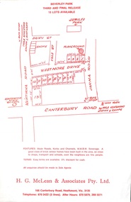
Flyer, Land Sale Advertisement, Beverley Park, Heathmont - circa late 1970s
Single sided leaflet with red printSubdivision includes Wantirna Road, Daisy Street, Vale Street, Westmore Drive, Jarma Road, Canterbury Road. Sole Agents - H.G. McLean & Associates Pty. Ltd. 166 Canterbury Rioad, Heathmont, Vic. 3135 Telephone 870 3422 (3 lines) After Hours 870 5879, 288 5071 -
 Kew Historical Society Inc
Photograph, Stuart Tompkins Studio, Electricity Supply Poles, Warrigal Road, Holmesglen, 1965
Research provided by Stuart Tompkins Studio, Box Hill, into alternatives for median strip street lighting to be used in Burke Road, Kew. The photographers identified variants in different suburbs appropriate to Kew's needs. The series from which the photograph is drawn provides a snapshot by a commercial photographic studio of each named vicinity in 1965 as well as providing examples of public works infrastructure being commissioned by local government in the 1960s. The photos originally formed part of the Engineering Department's files in the City of Kew before being donated to the kew Historical Society.Electricity Supply Poles, Warrigal Road, Holmesglen, 1965. Stuart Tompkins Studio provided this photograph for the Kew City Council. The photograph of Warrigal Road, north of Holmesglen looking north depicts wooden poles with bracket light fittings. These were the same as those proposed for Kew, except the lights and fittings were not to be 350 watt. Mercury lamps were preferred. [There are three copies of this photograph in the Collection.] Typed inscription on reverse: "Electricity Supply Poles. Photographed for Kew City Council 8/2/65. No.3 Warrigal Road - North of Holmesglen looking north. Wooden poles with bracket fittings same as those proposed for Kew except lights and fittings are not for 250 watt c. c. mercury lamps proposed. Wooden pole 3' up 11 3/4" dia." Studio stamp: "Stuart Tompkins Studio. 547 Station Street, Box Hill. WX1439."stuart tompkins studio, warrigal road (holmesglen) 1965, street lighting -
 Ringwood and District Historical Society
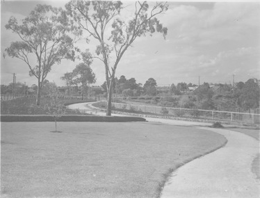
Photograph, Warrandyte Road, east side, to Aird Street and bowling green. Jan. 1975
Written on back of photograph, "Warrandyte Road, east side, to Aird Street and bowling green. Jan. 1975". -
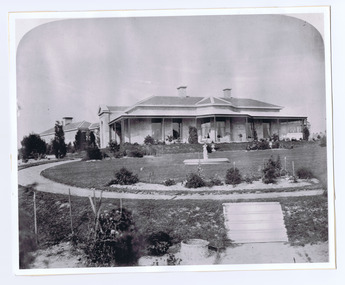 St Kilda Historical Society
Photograph - Photograph Building, Donald McDonald, 1872
Residence of William A Brahe, Solicitor. Subsequently demolished for flats.black and white photograph copyAlma street (now Alma Road) Residence of William A Brahe, Solicitor Taken 1872 converted to Flats -
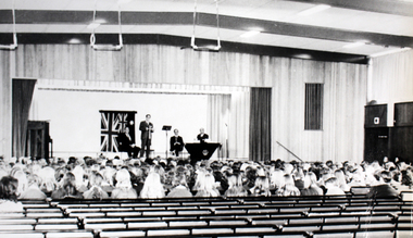 Williamstown High School
1972 New assembly hall
Copy of black and white photograph of interior of the assembly hall with staff and students. Mounted on board, this photo is accompanied by a caption.Caption reads: The new assemblt hall. On the corner of Melbourne Road and Pasco Street Williamstown. Opened in 1972.williamstown high school, 1972, assembly hall, opening -
 Ringwood and District Historical Society
Photograph, Maroondah Highway Central, Ringwood. Looking west from Warrandyte Road, 1960
Black and white photograph (2 copies)Written on back of photograph: "Maroondah Highway looking west near Pratt Street. Warrandyte Road on right. -
 Marysville & District Historical Society
Photograph (Item) - Colour photograph, Travel Victoria, Unknown
A colour photograph of Murchison Street in Marysville in Victoria.A colour photograph of Murchison Street in Marysville in Victoria. The photograph shows The Crossways Hotel. The Crossways Hotel is circa 1920 and one of the oldest buildings still standing in Marysville. The Crossways Hotel survived the 2009 Black Saturday bushfires, through the efforts of the owner using buckets of water from the nearby Steavenson River.murchison street, marysville, victoria, the crossways hotel, photograph, 2009 black saturday bushfires -
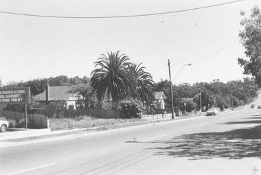
 Eltham District Historical Society Inc
Photograph, Main Road, Eltham
Three photographs looking north along Main Road towards Arthur Street near Eltham Shopping Centre.main road, arthur street, eltham, shops -
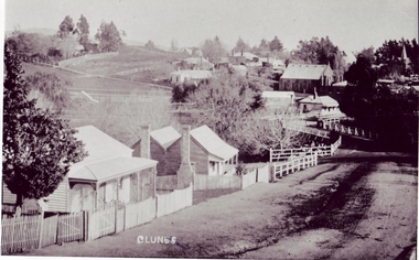 Clunes Museum
Photograph
EARLY SCENE OF CLUNESCOPY OF STREET SCENE IN CLUNES, HOUSES IN CRESWICK ROAD, GOVERNMENT BRIDGE IN THE CENTRE, WITH BIBLE CHRISTIAN CHURCH IN BACKGROUND.local history, photography, photographs, buildings -
Whitehorse Historical Society Inc.
Newspaper - Article, My how times have changed, 20/11/1985
Article on Whitehorse Road, Mitcham with photo showing Britannia Street Guide Hall (Mitcham Hall), by Simon Kinch.mitcham, edward street, mitcham, britannia street mitcham, whitehorse road, mitcham, christ church anglican church mitcham, guide groups, mitcham hall