Showing 1514 items
matching sanding
-
 Tatura Irrigation & Wartime Camps Museum
Water Wheel Accuracy Tester, Late 1900s
Used by State Rivers and Water Supply Commission prior to their privatisation about 1990.A clear tube with sand inside - similar to an egg timer. Used to measure the accuracy of water wheels over a half minute or less. Measurements marked on outside and related to one revolution. The blue scales relate to small meter outlets(wheels), yellow scales related to large meter outlets(wheels).Figures of rates relating to measurement of water in one revolution.irrigation, victoria state rivers and water supply commission, water wheel -
 Lakes Entrance Historical Society
Photograph - Lakes Entrance, 1945 c
The Hulk of the Baang Yarnda on the North Arm foreshore. (Note in album)Black and white photograph showing view from Kalimna cliff overlooking North Arm and township, Cunninghame Arm and sand dunes out to Bass Strait. Hulk of old Baang Yarnda moored in North Arm, towed there in 1939 and left to rot. Thick vegetation in foreground. Lakes Entrance Victoria.township, waterways -
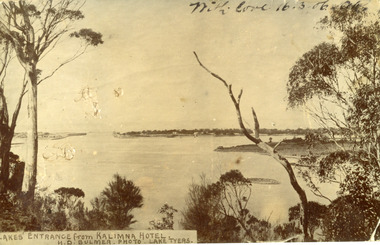 Lakes Entrance Historical Society
Postcard - The Entrance
Black and white post card showing the man made entrance through the hummock. It shows the fishermen's cottages on the western side of the entrance, Rigby Island and the Doughboy, small island, with salt affected vegetation and a small sand bar in the channel. Natural vegetation of Kalimna cliff in foreground. Lakes Entrance VictoriaLakes Entrance from Kalimna Hotel waterways, topography -
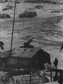 National Vietnam Veterans Museum (NVVM)
Photograph, Gibbons, Denis, Quiet Time
Denis Gibbons (1937 – 2011) Trained with the Australian Army, before travelling to Vietnam in January 1966, Denis stayed with the 1st Australian Task Force in Nui Dat working as a photographer. For almost five years Gibbons toured with nine Australian infantry battalions, posting compelling war images from within many combat zones before being flown out in late November 1970 after sustaining injuries. The images held within the National Vietnam Veterans Museum make up the Gibbons Collection. A black and white photograph of a quiet time, in a gun detachment area at an Australian Fire Support Base, in the sand dunes, on the coast, South East of the 1st Australian Task Force Base at Nui Dat, Phuoc Tuy Province, South Vietnam. The Battery was supporting Infantry in the area (circa June 1970).photograph, fire support base, 1st atf base, nui dat, phuoc tuy province, infantry, gibbons collection catalogue, photographer, vietnam war, denis gibbons, 105mm howitzer, nui thai vai mountains -
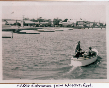 Lakes Entrance Historical Society
Photograph - Boat Harbour, 1925c
Black and white photograph of the western end of Esplanade, showing guest houses, businesses, Police Station, Methodist Church, cars parked in front of buildings, Bluestone wall at edge of lake, timber groynes for sand control. On lake a small motor boat containing two men. Lakes Entrance VictoriaLakes Entrance from western end.police, religion, waterfront, boats and boating, township -
 Torquay and District Historical Society
Photograph (copy)
shows small child with a blow up beach ball playing in the sand. location Cosy Corner, Torquay front beach, young Norfolk Pine trees, rotunda and old toilet block.black and white photo, rectangular.torquay beach, rotunda, norfolk pines -
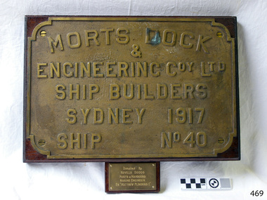 Flagstaff Hill Maritime Museum and Village
Plaque - Nameplate, Morts Dock & Engineering Co. Ltd, Matthew Flinders I, 1917
... sanding ...This nameplate was attached to the steel steamer Matthew Flinders I, a Suction Hopper Dredge used for pumping up sit and sanding from seabeds. It was donated by the Marine Engineer, Neville Dodds, from Ports and Harbours, from the Matthew Flinders I. The Matthew Flinders was constructed by Morts Dock & Engineering Coy. Ltd in Sydney, New South Wales. Identified as Ship No. 40, the dredge had twin screw engines that were made in Sydney. Its gross tonnage was 1180. It was launched on July 15th, 1916, and registered in 1917 at the Port of Melbourne by the owner, the Department of Public Works in Victoria. Unlike bucket dredges, the Matthew Flinders did not use permanent moorings but instead had bow and stern anchors. It travelled forward on the bow anchor, taking up a strip of even-depth wilt from the bed below. A local newspaper noted that the Matthew Flinders has many advantages that were especially useful for its work at Warrnambool. Warrnambool Harbour had been experiencing silting and sanding for many years. The problem continued even after the construction of the Breakwater in 1890, which was overseen by New Zealand engineer Arthur Dudley Dobson. Melbourne’s Department of Ports and Harbours sent the new Matthew Flinders to dredge the heavy silting in the Warrnambool Harbour in May 1919. This work was previously done by the smaller dredge, the Pioneer. However, after a month of work, the Matthew Flinders was returned to Melbourne for alterations to make it suitable for work in the heavy seas it experienced at Warrnambool. Both dredges were sent up from Melbourne when required over the years to periodically attend to the silting in the Harbour, but the Matthew Flinders was preferred because of its efficiency. It was still dredging the Harbour even in July 1938. The ship’s original master was J G Rosney. In February 1922 Percy Taylor from Ports and Harbours joined the Matthew Flinders as a Mate. 1923 the master in charge was Captain Dunbar. In August 1926 Percy Taylor was appointed as her Master and was later transferred to the Pioneer as Master in 1933. 1930 the dredges were no longer required as the Harbour was no longer suitable as a port. However, one source notes that the Matthew Flinders was still dredging the Harbour in 1938.This nameplate is significant for its association with the suction hopper dredge Matthew Flinders I, which was used to remove the build-up of silt and sand from the Warrnambool Harbour, allowing shipping activities to continue to operate in the Port of Warrnambool. The nameplate identifies the vessel and shows that it was built in Australia in the early 20th century for use within Australia. The need for dredging in the Warrnambool Harbour was a serious and ongoing problem, as silting continued to happen after a series of measures were taken to try and resolve the issue. Eventually, the Harbour could no longer function successfully as a port.Brass nameplate, rectangular with cut-away corners and moulded text, mounted with screws on timber. The plate is from a vessel, the dredge Matthew Flinders I, ship no. 40, built by Morts Dock & Engineering Coy Ltd in Sydney, and registered in 1917. A small rectangular engraved plaque below the nameplate gives further details of the ship and the donor.On nameplate: "MORTS DOCK / & / ENGINEERING COY. LTD. / SHIP BUILDERS / SYDNEY 1917 / SHIP NO 40" On small plaque: "Donated by / NEVILLE DODDS / PORTS & HARBOURS / MARINE ENGINEER / EX "MATTHEW FLINDERS I"flagstaff hill, warrnambool, maritime village, maritime museum, flagstaff hill maritime museum & village, shipwreck coast, great ocean road, dredge, mathew flinders i, steel steam ship, twin screw engines, nsw, state of victoria, suction hopper, public works melbourne, warrnambool harbour, lady bay, sanding, silting, breakwater, morts dock & engineering co ltd, captain dunbar, ship no. 40, niville dodds, ports & harbours, marine engineer, marine technology, ship relic, percy taylor, matthew flinders, pioneer -
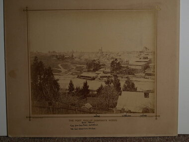 Clunes Museum
Photograph, BEAUCHAMP PHOTOGRAPHY, CIRCA 1884 - 1885
SEPIA PHOTOGRAPH OF PORT PHILLIP COMPANY'S WORKS.THE PORT PHILIP COMPANY'S WORK'S. HANDWRITTEN NOTES: PERIOD 1884 OR 5. TAKEN FROM CAMP PARADE: NOERTH WEST END NOTE SAND ALLOWED TO RUN INTO CREEK NORTH SHAFT, 2ND BATTERY HOUSE, SOUTH SHAFT. BEAUCHAMP PHOTO, 104 STURT STREET, BALLARATlocal history, mining, port phillip mine -
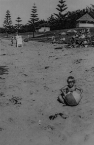
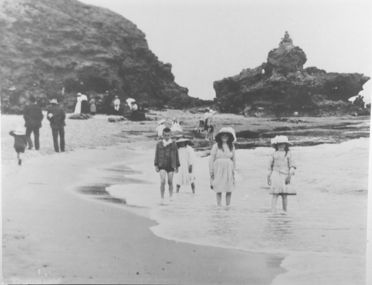 Torquay and District Historical Society
Black and white photograph, Early Torquay Beach Scenes
Photograph likely taken at the mouth of Spring Creek where it enters the sea at the Torquay back beach. Three girls and a boy are wading in the creek watched by adults wearing suits and dresses standing on the sand.A picture of beach recreation in past times.Black and white photographtorquay victoria -
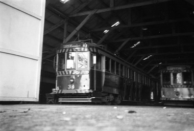 Ballarat Tramway Museum
Photograph - Digital Image, Peter Knife, SEC 34 and 28 in Depot, May 1963
Digital image of SEC 34 and 28 in Depot. Shows the roof structure of the depot. Note the wheel barrow to the left of tram 34 containing sand for the trams. Photo by Peter Knife May 1963,Yields information about Ballarat's trams and the SEC depot in 1963.Digital image of a black and white negativetramways, tramcars, ballarat, tram 34, sec depot, tram 28 -
 Bendigo Military Museum
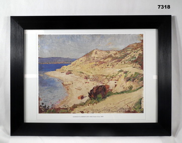
Print - PRINT, FRAMED WW1, Reader's Digest (Australia) Pty Limited, 2015
From Information book; "Reader's Digest/ Gallipoli/ 25th April 1915 - 9th January 1916/ Centenary Commemorative Prints". Collection of 20 prints. Refer Cat No. 7300.Framed print. Print - colour print on paper. Copy of an oil painting with pencil on wood. Depicts a cove with sea, sand and hills. Ruined buildings and structures visible on the beach. Horse eating grass in the foreground. Frame - Black plastic framing with glass front and MDF board backing with adhered black paper.Details below print - in black ink; " GEORGE W LAMBERT (1873-1930) Anzac Cove, 1919" “GEORGE W LAMBERT, unable to enlist in the Australian Imperial Force in London, joined Voluntary Training Corps". Appointed an official Australia War Artist, Australian Imperial Force 1917. framed accessories, prints, ww1, gallipoli, centenary -
 Bendigo Historical Society Inc.
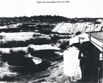
Photograph - LONG GULLY HISTORY GROUP COLLECTION: LONG GULLY AREA
Copy of a black and white photo of the Long Gully Area before the Long Gully Estate was built. On the right is a small and a larger buildings. Beside the buildings are two large open vats. One has a pipe with liquid flowing into the vat. The centre of the photo is mostly sand dump and tussocks. In the background is bush and houses.bendigo, history, long gully history group, the long gully history group - long gully area -
 Bendigo Historical Society Inc.
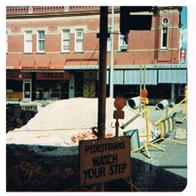
Photograph - EVA WILSON COLLECTION: HARGREAVES MALL CONSTRUCTION
Image shows Mitchell street end of Hargreaves Mall, looking east towards Colliers Bootery. Pile of sand in centre of image, 'pedestrians watch your step' sign in foreground. On back Hargreaves St Mall at Mitchell st. corner, looking east. Photo taken about 6 - 7 p.m.place, bendigo, hargreaves mall, bendigo, hargreaves mall, colliery bootery -
 Lakes Entrance Historical Society
Postcard, 1928c
Black and white photograph of Whiters Park, showing residence and office, gardens, tennis court, early model car by the petrol bowser, electric lights on tall poles. Opposite park entry is Aults Motor Engineer, scattered cottages. In distance is Cunninghame Arm, sand hummocks and ocean. Lakes Entrance Victoriaresort, township, transport, recreation -
 Lakes Entrance Historical Society
Postcard - Bullock Island
Black and white postcard of west end of Bullock Island, showing rock groynes around island, wooden entrance piers in entrance to Gippsland Lakes from Bass Strait, sand dunes showing New Works houses and sheds. A tree branch across top and foreground shrubbery. Lakes Entrance VictoriaLooking towards Lakes Entrance (on front)islands, waterways, room display -
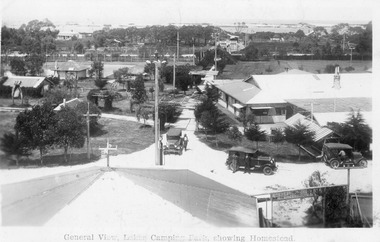
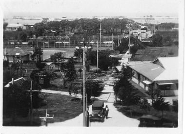 Lakes Entrance Historical Society
Photograph - Whiter's Camp Park, 1928c
Also postcard size black and white same scene but larger view with two vehicles, with inscription-General view Lakes camping park showing homestead.|Larger copy has the inscription Beautiful view of park from Whiters Lookout Tower.Black and white photograph of Whiters Park, showing residence and office, gardens, tennis court, early model car by the petrol bowser, electric lights on tall poles. Opposite park entry is Aults Motor Engineer, scattered cottages. In distance is Cunninghame Arm, sand hummocks and ocean. Lakes Entrance Victoriaresort, township, transport, recreation -
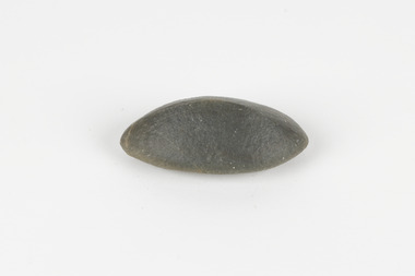 The Beechworth Burke Museum
Geological specimen - Ventifact (wind- or ice-shaped) pebble
Ventifacts are sand-blasted rocks that are typically faceted and often display parallel grooves carved by wind-blown sand. They are useful indicators of wind direction and strength in environments such as deserts, mountains, and coastal areas because they are usually not hidden by later sediment, soil or vegetation cover. In Antarctica ventifaction is strongly related to the composition or type of rock. Ventifacts are important because they provide evidence for abraders such as sand, dust or snow and ice crystals, and offer a unique understanding of past wind processes that are effective in the reconstruction of past wind flow conditions and can provides clues to weather and climate changes in the past. Interestingly ventifacts have also been found on the surface of Mars. They were a threat to the NASA rover due to the sharp angles of the facets, created by the Martian wind over the course of millions of years. These Martian ventifacts act like weathervanes for past wind and weather patterns on the red planet in a similar manner to those found on earth.The Geological Survey of Victoria was instigated in response to the Victorian Gold Rush which began around 1851 in the Beechworth, Castlemaine, Daylesford, Bendigo and Ballarat areas. The survey was conducted by Alfred Richard Cecil Selwyn from his arrival in December 1852 until his resignation in 1869and during this time he trained many notable geologists, e.g. Aplin, Wilkinson, Daintree, who went on to other State survey senior positions. This specimen was among those donated to the Burke Museum in 1868.A hand-sized solid mineral specimen in shades of dark and light browns with light lines visible in all configurations and a groove on configuration 2.light lines visible in all configurations and a groove on configuration 2burke museum, beechworth, geological, geological specimen, ventifact, antarctic region, antarctic, alfred richard cecil selwyn, alfred selwyn, wind direction, wind strength, abraders, wind flow, climate change, reconstruction of wind flow conditions, weather change, mars -
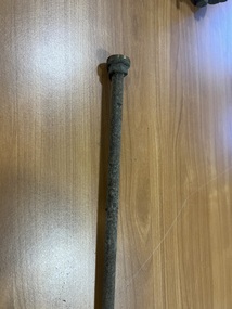 Ballarat Tramway Museum
Equipment - Length of tramcar air pipe, c1920
Example of small diameter airpipe for the supply of air to the air gauge or sanding mechanism. Recovered from tram 14 during the project to replumb or replace the air system on the tram. Has been corroded internally.Yields information about the size of air piping fitting to a tram.Length of steel air pipe - with screw thread at one and half of brass union at the other. Has corroded internally.tram 14, tramcars, tramcar maintenance, air gauges, piping -
 The 69 Collective
Painting, Leah Mariani, Beach bums, 2013
This artwork is part of 69Fifteen, the book published in 2013 celebrating 69 Smith Street Gallery’s 15th year in operation as an artist-run space.Oil on cotton fabric. Image of two young boys standing beside each other looking out to sea. They are painted against a background of blue-green water and a clear blue sky. The pattern on the sand is repeated in the boys' swimming costumes. One of the boys has his head turned away from the water.leah mariani, 69 smith street gallery, artist-run initiative, artist-run space, melbourne art galleries, painting, www.leahmariani.com -
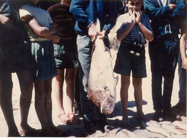 Southern Sherbrooke Historical Society Inc.
Photograph
Colour photograph of a group of people after having caught a snapper at Rosebud in 1960. Seven people are standing in a row on the sand with one of them holding the snapper that's almost as long as their legs. A boy on the right has his hands to his mouth, whilst everyone else's heads have been cropped off. -
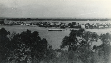
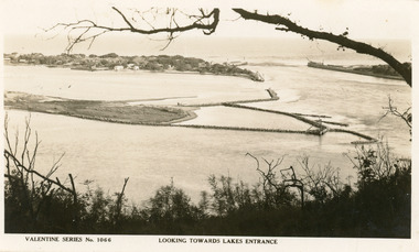
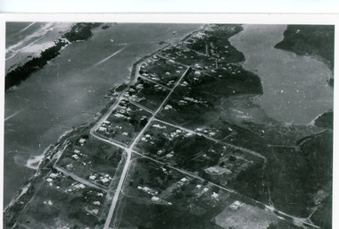 Lakes Entrance Historical Society
Photograph - Lakes Entrance, Bulmer H D, 1940c
Black and white photograph of aerial view of township. It shows route of Princes Highway through town, turning north at Myer Street and continuing along Roadknight Street. Few jetties on North Arm, many on Cunninghame Arm. In far upper left of image sea is breaking on sand hummocks. Lakes Entrance Victoriawaterways, township -
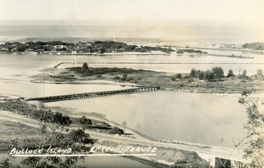 Lakes Entrance Historical Society
Postcard - Bullock Island, Bulmer H D, 1945
Black and white postcard of Bullock Island, Lakes Entrance, showing an extensive rock groyne to the south of the island, into which dredged sand and spoil is to be placed in order to extend the island's area. North Arm bridge, Bullock Island footbridge, New Works settlement and Entrance channel also in image. Lakes Entrance VictoriaBullock Island, Lakes Entranceboats and boating, fishing industry, islands -
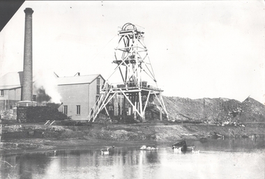 Bendigo Historical Society Inc.
Photograph - FORTUNA COLLECTION: HUSTLERS AND ENERGETIC MINE
Black and white photograph of mine site. Metal poppet head in centre, engine room buildings on LH side. Brick chimney extreme left. Large mullock/sand heap on RH side. Mine dam in foreground, three geese floating in water. In front of poppet head, horse drawn wooden cartbendigo, mining, hercules and energetic mine -
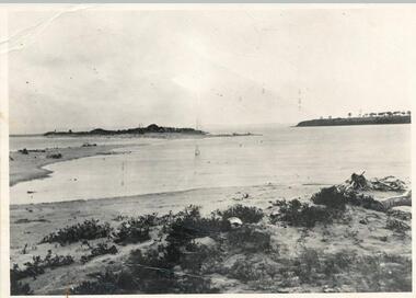 Phillip Island and District Historical Society Inc.
Photograph, 1890 - 1900
Sandy Island (no longer in existance) on the extremity of the sand spit on the north side of the "Nit" near Rhyll, Phillip Island. The original picture in the possession of Mr Les Findlay of Cowes was taken probably about 1890-1900.Black & White photograph of Sandy Island Rhyll - now gone.See below under History of Object.sandy island rhyll, arthur woodley -
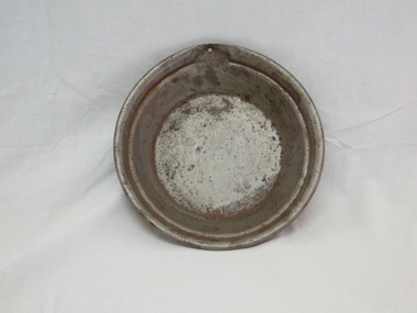 Bright & District Historical Society operating the Bright Museum
Pan gold
Gold pans were used to separate gold flakes or particles from alluvial deposits by washing and discarding sand, gravel and the like. This pan is very small and may have been produced for demonstration or display purposes.Gold pans had widespread use wherever alluvial deposits were found an d water was available.Gold Pan. Smal size, as to have been galvanised. Diameter 240mmgold, gold pan, goldfields -
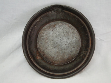 Bright & District Historical Society operating the Bright Museum
Pan gold
Gold pans were widely used in alluvial gold fields for seperating particles or flakes of gold from gravel, sand and the like. This one is small and may have been used for demonstration only or for display purposes.Gold pans had widespread use in alluvial gold fields where water is available.Gold Pan, small. Diameter 240mm.gold, gold pan, goldfields -
 Lakes Entrance Historical Society
Photograph - Lake Bunga, M Holding, 1/06/1998 12:00:00 AM
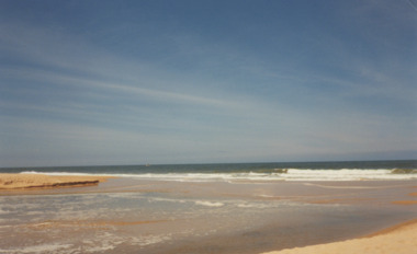
Also a second coloured photograph showing expanse of sand on western shore with Mrs Glad Scarce seated on fence looking at open entrance Lake Bunga number 03849.1 size 10 x 15 cmColour photograph of the open entrance after an unusual weather condition Lake Bunga Victoriawaterways, lake bunga -
 Glenelg Shire Council Cultural Collection
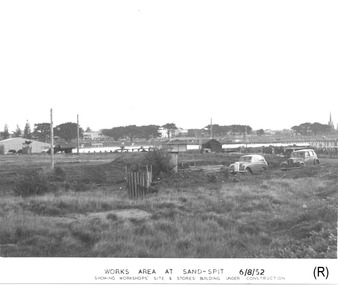
Photograph - Photograph - Portland Harbour Trust - Works area at Sand-spit, 6.8.52, 1952
Port of Portland Authority archivesFront: WORKS AREA AT SAND-SPIT. 6/8/52/ SHOWING WORKSHOPS' SITE & STORES BUILDING UNDER CONSTRUCTION (lower centre) Back: P.H.T./ Print No. 3/3 Neg. No // Date taken 6-8-52./ SUBJECT./ % (Ink stamp with blue pen and pencil additions, centre)port of portland archives -
4th/19th Prince of Wales's Light Horse Regiment Unit History Room
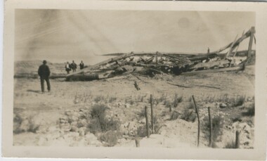
Field Sketch, From General Chaytor's HQ After the battle of Bir El Abd, c 1917
A field sketch by Sgt Otho Hewett looking North toward Bir El Abd (a well near Arish). The country depicted is a vast area of sand dunes, with the only named features being the Canterbury MR Graves, Bir El Abd (a well), graves, Hod el Zawara and Old Turk telegraph line.field sketch, bir el abd -
 Bendigo Historical Society Inc.
Photograph - IRONBARK MINE, NEW CHUM REEF, BENDIGO, 1930 ?
black and white photo: collapsed wooden poppet head of the Ironbark Mine, four men on the left hand side., with engine holding down bolts in the right foreground. 'Old Ironbark, New Chum Reef ?' 26.11.1999 Previous mng 39 In pen - Ironbark legs looking from the tram track and sand heap behind it.organization, business, ironbark mine