Showing 8789 items
matching south road
-
 Whitehorse Historical Society Inc.
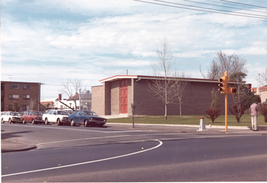
Article, $2.7m nursing home opens, 1987
... at the Inala Village complex in Middleborough Road, Blackburn South.... complex in Middleborough Road, Blackburn South. A new $2.7million ...A new $2.7million 40 bed nursing home opened last week at the Inala Village complex in Middleborough Road, Blackburn South.A new $2.7million 40 bed nursing home opened last week at the Inala Village complex in Middleborough Road, Blackburn South.A new $2.7million 40 bed nursing home opened last week at the Inala Village complex in Middleborough Road, Blackburn South.inala village, aged people, nursing homes -
 Whitehorse Historical Society Inc.
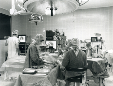
Photograph, Bellbird Private Hospital, 1994
... Roads, Blackburn South. 1994... Hospital, Cnr. Canterbury and Blackburn Roads, Blackburn South ...Black and white photograph taken inside the operating theatre of the Bellbird Hospital, Cnr. Canterbury and Blackburn Roads, Blackburn South. 1994bellbird private hospital -
Canterbury History Group
Photograph - Demolition works in Maling Road 1992-3, Jan Pigot, 1992-3
... showing demolition works on south side of Maling Road 1992-3...Canterbury History Group 190A Canterbury Road Canterbury ...Part of a set of eight photographs taken by Jan Pigot showing demolition works on south side of Maling Road 1992-3canterbury, maling road -
Glenelg Shire Council Cultural Collection
Photograph - Photograph - Dutton Way, 1976
... Black & white photo looking south along Ferguson's Road... Cliff Street Portland great-ocean-road Port of Portland ...Port of Portland Authority ArchivesBack: Dutton Way - pencil, lines leading to grey stamp. Location Date 30.6.76 - blue biro Time Reference 74/15 - blue biro -
 Vision Australia
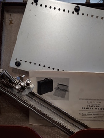
Equipment - Object, Stainsby-Wayne, Stainsby Braille writer in case, 1933-1980
... Road, South Yarra". ... Road, South Yarra". Silver Brailler, rectangular with six ...The Stainsby Braillewriter was utilised by Braille tutors and volunteers as well the blind and visually impaired. Stored in a brown cardboard lockable case and this complete kit consists of a metal Braille writing machine; a long slim rectangular device with carriage and six silver keys and a bell, a metal board to attach Braille writer, a metal hinged Braille paper clamp and an instructional booklet. Henry Stainsby (1859-1925), Supt. of the Birmingham Royal Institution for the Blind, (later General Secretary of the British & Foreign Blind Association) along with Birmingham manufacturer Albert Wayne, introduced their portable brailler writer around 1903. An "improved" version, featuring aluminum parts and a paper clamp allowing accurate interpointing or interlining, was announced in "Outlook for the Blind" as early as 1927 and available generally by 1933 in the RNIB catalog. By 1978, RNIB sold the Improved Stainsby in a number of formats, including a large version available with interlining and inter-pointing board, and a small version with a folding board. Both large and small models came in ordinary and reverse keyed versions. Silver Brailler, rectangular with six silver keys and a bell, with paper board and clip, in cardboard suitcaseM8839 M88 (Brailler) M 8839 (Board) On the outside of the suitcase an address label reads "Braille Library, 31-51 Commercial Road, South Yarra". braille equipment, assistive devices -
 Surrey Hills Historical Society Collection
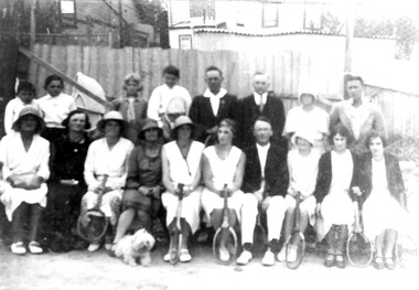
Photograph, Tennis Club, Durham Road area, 1930s
... The club was located at the south end of Durham Road...The club was located at the south end of Durham Road ...The club was located at the south end of Durham Road, Surrey Hills in the 1930s. Black and white photo of members of a tennis club. There are 18 people in the photo - 10 adult females, 4 adult males, 3 younger males and a small dog; 6 females and 2 males are holding tennis racquets. There is a wicker baby's pram behind the group and in the background are the backs of houses.Top in biro in Jocelyn Hall's hand: "For Neighbourhood Centre" then below: "App. 1930" At the bottom in grey pencil: "TENNIS CLUB (BOTTOM OF DURHAM RD) / BACK OF HOUSES IN THAMES ST."tennis, sports and recreations, thames street, durham road, w prewett -
 Eltham District Historical Society Inc
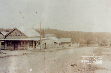
Photograph, Main Road, Eltham
... Colour photograph of original image showing Main Road... photograph of original image showing Main Road looking south from ...Colour photograph of original image showing Main Road looking south from Franklin Street with W. B. Andrew Corn Store.eltham, main road, franklin street, shops, w.b andrew -
 Whitehorse Historical Society Inc.
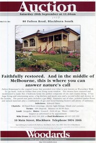
Pamphlet - Real Estate Notice, Fulton Homestead, 1/09/1997
... Auction notice for Fulton Homestead, 80 Fulton Road...Whitehorse Historical Society Inc. 2-10 Deep Creek Road ...Auction notice for Fulton HomesteadAuction notice for Fulton Homestead, 80 Fulton Road, Blackburn South at Wurundjeri Walk. Plan on verso. Auctioneer, Woodards, Coloured Photograph.Auction notice for Fulton Homestead wurundjeri walk, auctions, fulton road, blackburn south, fulton homestead -
Whitehorse Historical Society Inc.
Newspaper - Article, Blackburn Road, 9/06/1993
... density development in Blackburn Road, Blackburn South... Mitcham melbourne Blackburn Road Blackburn South Townhouses ...Photograph of Cr David McKittrick with an example of higher density development in Blackburn Road, Blackburn South, in Nunawading Gazette, 9 June 1993.blackburn road, blackburn south, townhouses, mckittrick, david -
 Ballarat Tramway Museum
Photograph - Colour Print/s, Warren Doubleday, 14/09/2003 12:00:00 AM
... of the Grey St Loop, looking south. Shows the road layout in 2003...Ballarat Tramway Museum South Gardens Reserve Wendouree ...Colour photograph of Albert St. Sebastopol at the site of the Grey St Loop, looking south. Shows the road layout in 2003. Photo taken by Warren Doubleday on 14/09/2003. Printed on Agfa paper. On rear of each photo in brown felt tip pen, the words "Grey St. Loop site" and "14/9/02".albert st, grey st loop -
 Eltham District Historical Society Inc
Photograph, Main Road widening, Eltham, c.March 1968, 1968
... Immediately prior to duplication of Main Road. Looking... melbourne Immediately prior to duplication of Main Road. Looking ...Immediately prior to duplication of Main Road. Looking south towards Bridge Street.35mm Colour positive transparency Mount - Agfacolor Service (Blue stepped)bridge street, duplication, eltham, main road -
 Ringwood and District Historical Society
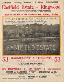
Flyer, Subdivisional Land Auction Sale Brochure, Eastfield Estate, Ringwood, Vic. - 1920
... Subdivision includes Croydon South streets - Eastfield Road... South streets - Eastfield Road, Long View Road, The Mount ...Bi-folded double sided land advertisement for subdivision auction on Saturday, December 11th, 1920, for Eastfield Estate with location map and summary of local facilities and services.Subdivision includes Croydon South streets - Eastfield Road, Long View Road, The Mount, and Pleasant Rise. Local Agent - Godbehear & Co, Phone Ringwood 49. -
 Rutherglen Historical Society
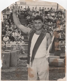
Image, Ern McQuillan, 1950s
... | FM 1766" above - "By Ern McQuillan, 396 New South Head Road... New South Head Road, Double Bay" below - "A Photographic ...Tommy Bartel Champion AxmanBlack and white photograph of sportsman with championship ribbon around neck and an axe in his handOn back of photo: Stylised image of a camera with "FM 1764 | FM 1766" above - "By Ern McQuillan, 396 New South Head Road, Double Bay" below - "A Photographic Illustrators Photograph" to the right - with numbers "4/4526/59" hand written in red ink.tommy bartel, wood chopping, sports, champions, tommy bartel was married to freda ward bartel. they both were born in beechworth victoria. tommy and his family were known for their wood chopping prowess both as workers and competitive axemen. tommy’s wife freda and his descendants reside in rutherglen., freda bartel, freda ward -
Whitehorse Historical Society Inc.
Newspaper - Article, 25-29 Glenburnie Road, Mitcham, 15/05/1996
... , known as 'Old Daffodil Farm'. Also 95 Morack Road, Vermont South...Glenburnie Road, Mitcham, No 25 - 29|Morack Road, Vermont... Farm Morack Road Vermont South No. 95 Auctions Sale ...Sale advertisement for 25 - 29 Glenburnie Road, Mitcham, known as 'Old Daffodil Farm'. Also 95 Morack Road, Vermont South for auction.glenburnie road, mitcham, nos. 25-29, old daffodil farm, morack road, vermont south, no. 95, auctions -
 Whitehorse Historical Society Inc.
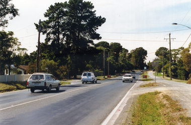
Postcard, Historic Postcard - Set 2 no 3 - Blackburn Road, 1914
... Road, looking south in 1914. Photo supplied by Keith Rooney - 2... (Set 2 No 3) Blackburn Road, looking south in 1914. Photo ...Black and white historic postcard (Set 2 No 3) Blackburn Road, looking south in 1914. Photo supplied by Keith Rooney - 2 copiesrooney, keith, blackburn road, blackburn, nunawading library & information service -
 Kew Historical Society Inc
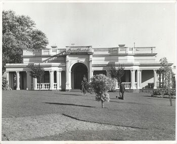
Photograph - 'Southesk', Cotham Road, c. 1965
... The front garden and facade of South Esk in Cotham Road... and facade of South Esk in Cotham Road, Kew, during the period when ...Ordsall (c.1864-1970) - Situated on the southwest corner of Cotham Road and Charles Street, the single-storey Italianate mansion, Ordsall, was built for John Halfey in the 1860s. Following extensions in 1878 and 1881to designs by Michael Hennessy, Halfey commissioned the decorating firm of Cullis Hill & Co to create elaborate coloured frescoes on the ceilings of the drawingroom and ballroom in 1882. These frescoes were among the finest created in Melbourne during this period. Sold in 1905 to David Carnegie, and renamed South Esk, it was sold to the City of Kew in 1947 and demolished in 1970.This work forms part of the collection assembled by the historian Dorothy Rogers, that was donated to the Kew Historical Society by her son John Rogers in 2015. The manuscripts, photographs, maps, and documents were sourced by her from both family and local collections or produced as references for her print publications. Many were directly used by Rogers in writing ‘Lovely Old Homes of Kew’ (1961) and 'A History of Kew' (1973), or the numerous articles on local history that she produced for suburban newspapers. Most of the photographs in the collection include detailed annotations in her hand. The Rogers Collection provides a comprehensive insight into the working habits of a historian in the 1960s and 1970s. Together it forms the largest privately-donated collection within the archives of the Kew Historical Society.The front garden and facade of South Esk in Cotham Road, Kew, during the period when it was owned by the City of Kew. The mansion was demolished by the City in 1970."2. Chap 22 Southesk . Ordsall John Halfey. Orig. part to 1858. Additional about 1862. Southesk once Ordsall . Demolished to make way for Municipal Chambers. Commenced approx. 1858 added front by John Halfey 1862."south esk, ordsall, david carnegie, kew city council, cotham road (kew), dorothy rogers, john halfey -
 Eltham District Historical Society Inc
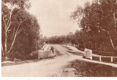
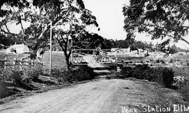
Negative - Photograph, Near station, Eltham, c.1910
... Eltham - Main Road. Looking south near Railway Station... melbourne Eltham - Main Road. Looking south near Railway Station ...Eltham - Main Road. Looking south near Railway Station. Diamond Street on right. This photo forms part of a collection of photographs gathered by the Shire of Eltham for their centenary project book,"Pioneers and Painters: 100 years of the Shire of Eltham" by Alan Marshall (1971). The collection of over 500 images is held in partnership between Eltham District Historical Society and Yarra Plenty Regional Library (Eltham Library) and is now formally known as the 'The Shire of Eltham Pioneers Photograph Collection.' It is significant in being the first community sourced collection representing the places and people of the Shire's first one hundred years.Digital image 4 x 5 inch B&W Negsepp, shire of eltham pioneers photograph collection, eltham, main road, railway station, eltham railway station -
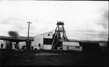 Stawell Historical Society Inc
Photograph, Native Youth Mine at Great Western showing buildings & Poppet Head on Poppet Head Road c1930's
... Head Road South of Great Western.... Road South of Great Western. mining gold Native Youth Mine ...Several photographs of Native Youth Mine at Great Western showing buildings and Poppet Head. 1930's. Located on Poppet Head Road South of Great Western.mining gold -
 Melbourne Tram Museum
Photograph - South Yarra Substation, Melbourne & Metropolitan Tramways Board (MMTB), 1966
... at the corner of Greville St and Punt Road South Yarra. See also item... of Greville St and Punt Road South Yarra. See also item 4515 ...Shows the completed sub-station, built during 1966 at the corner of Greville St and Punt Road South Yarra. See also item 4515 for construction photographs.Shows substation architecture of the 1960sSet of three colour photographs.trams, tramways, substation, electrical equipment, electrical switching, buildings -
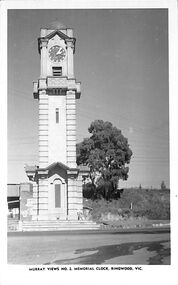 Ringwood and District Historical Society
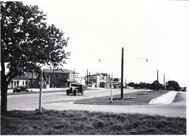
Photograph/Postcard, Postcard - Murray Views No.2 - Ringwood Main St and Clocktower in original position
... clock tower, cnr Maroondah Highway & Warrandyte Road, looking..., cnr Maroondah Highway & Warrandyte Road, looking south towards ...Black and white "Murray Views" postcard - Ringwood memorial clock tower, cnr Maroondah Highway & Warrandyte Road, looking south towards railway line.Front: "Murray Views No. 2 Memorial Clock, Ringwood, Vic." Back: "1948" handwritten. "Real Photograph Produced in Australia by Murray Views, Gympie, Q." -
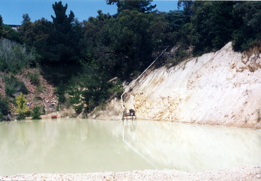 Whitehorse Historical Society Inc.
Photograph, Daniel Robertson Australia, 2000
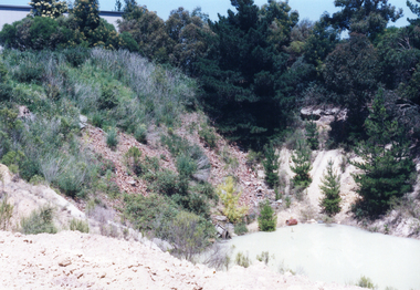
... Brickworks, looking South-East towards Norcal Road. Quarry located...Whitehorse Historical Society Inc. 2-10 Deep Creek Road ...Photo taken of old Quarry at the Daniel Robertson Brickworks, looking South-East towards Norcal Road. Quarry located behind present Brickwork Buildings.robertson, daniel, station street, nunawading, nos. 58 to 74, brickworks, quarries -
 Whitehorse Historical Society Inc.
Photograph, Daniel Robertson Australia, 2000
... Brickworks, looking South-East towards Norcal Road. Quarry located...Whitehorse Historical Society Inc. 2-10 Deep Creek Road ...Photo taken of old Quarry at the Daniel Robertson Brickworks, looking South-East towards Norcal Road. Quarry located behind present Brickwork Buildings.robertson, daniel, brickworks, quarries, station street, nunawading, nos. 58 to 74 -
 Whitehorse Historical Society Inc.
Photograph, Pannam's General Store
... on corner of Canterbury and Boronia Roads, Vermont,(South-East... of Canterbury and Boronia Roads, Vermont,(South-East corner), showing ...Part of The Shambrook Collection for 'This is Vermont', not used.Black and white photo of Chas. Pannam's General Store on corner of Canterbury and Boronia Roads, Vermont,(South-East corner), showing front of Delivery Truck.pannam's store, pannam, charles., shambrook, tim -
 Clunes Museum
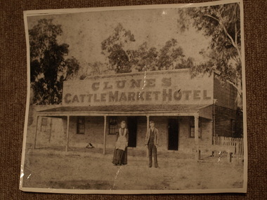
Photograph
... CLUNES CATTLEMARKET HOTEL. BUILT ON THE SOUTH SIDE... CATTLEMARKET HOTEL. BUILT ON THE SOUTH SIDE OF SMEATON ROAD BETWEEN ...CLUNES CATTLEMARKET HOTEL. BUILT ON THE SOUTH SIDE OF SMEATON ROAD BETWEEN DARLING AND BARKLEY STREETS..1.2 BLACK AND WHITE PHOTOGRAPH OF CLUNES CATTLEMARKET HOTEL, LOCATED ON SMEATON ROAD, CLUNES, MAN AND LADY STANDING IN FRONT .DOG RESTING ON VERANDAH. WOODEN CONSTRUCTION WITH SHINGLE ROOF. ENLARGED PHOTOGRAPHS .3-..6 BLACK AND WHITE PHOTOGRAPHS OF CLUNES CATTLE MARKET HOTEL..1 HANDWRITTEN ON BACKAUNTIE SIS AND UNCLE OWEN. MISS SYMONS AND BROTHER RELATED TO SPARKS . MAYOR - BUTCHER. CATTLE MARKET HOTELlocal history, photography, photographs, hotels - cattle market -
 Eltham District Historical Society Inc
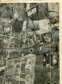
Photograph - Aerial Photograph, Landata, Montmorency, Vic, Apr. 1972
... , Montmorency bounded by Meruka Drive to north, Main Road to south, Main..., Montmorency bounded by Meruka Drive to north, Main Road to south, Main ...Centred on present day Olympic Avenue at Grand Boulevard, Montmorency bounded by Meruka Drive to north, Main Road to south, Main Road to east and Alban Street to west. Historic Aerial Imagery Source: Landata.vic.gov.au Aerial Photo Details: Project No :985 Project : MELBOURNE 1972 Run : 28 Frame : 206 Date : 04/1972 Film Type : B/W Camera : RC10 Flying Height : 5700 Scale : 9600 Film Number : 2635 GDA2020 : 37°43'21"S, 145°07'46"E MGA2020 : 335154, 5823329 (55) Melways : 21 E7 (ed. 42)aerial photo, neil webster collection, 1972-04, eltham, alban street, grand boulevard, lower plenty, main road, melway 21e7, meruka drive, montmorency, olympic avenue -
 Whitehorse Historical Society Inc.
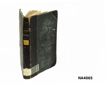
Book
... Ely Road South Box Hill and 31 Drummond Street Blackburn.... at Flower Farm Ely Road South Box Hill and 31 Drummond Street ...Originally in the Public Library of Victoria 1906. Collection of Margaret Scarlett. Used by her mother at Flower Farm Ely Road South Box Hill and 31 Drummond Street Blackburn.Dark green binding with black binding on back of book and each corner of book. Old stickers from Public Library Classification plus label in back of book for borrowers.Public Lending Library 1906 of Victoriabooks, medical -
 Whitehorse Historical Society Inc.
Map, Photo-map Ringwood A4A, 1945
... (North to south). Names of main roads inscribed.... Road (North to south). Aerial photo covering approximately from ...Aerial photo covering approximately from Box Hill to Mitcham (West to East) and Springfield Road to Hawthorn Road (North to south).Aerial photo covering approximately from Box Hill to Mitcham (West to East) and Springfield Road to Hawthorn Road (North to south). Names of main roads inscribed.Aerial photo covering approximately from Box Hill to Mitcham (West to East) and Springfield Road to Hawthorn Road (North to south).aerial photographs, box hill, blackburn, nunawading, forest hill, mitcham -
 Whitehorse Historical Society Inc.
Photograph, Mitcham Road Prior to Widening, 1/02/2000 12:00:00 AM
... Coloured photograph of Mitcham Road looking South towards... Coloured photograph of Mitcham Road looking South towards Mitcham ...Coloured photograph of Mitcham Road looking South towards Mitcham. Ruby Street on left, William Street on right. Taken prior to construction to widen Mitcham Road.mitcham road, donvale, ruby street, william street -
 Whitehorse Historical Society Inc.
Photograph, Whitehorse Road Mitcham, C1940s
... . Whitehorse Road looking south-west from ouside front of Memorial Hall... of Whitehorse Road, Mitcham - 1940s. Whitehorse Road looking south-west ...Black and white photo of Whitehorse Road, Mitcham - 1940s. Whitehorse Road looking south-west from ouside front of Memorial Hall towards Reserve Hotelwhitehorse road, mitcham -
 Whitehorse Historical Society Inc.
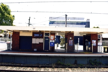
Photograph, Blackburn Railway Station, 2012
... station, heading west towards the 'city Entry is from Railway Road...Whitehorse Historical Society Inc. 2-10 Deep Creek Road ...See NP3406Coloured photograph of the railway line near the Blackburn station, heading west towards the 'city Entry is from Railway Road and South Parade via a tunnel - 2012blackburn railway station, railways