Showing 11155 items matching "street name"
-
 Eltham District Historical Society Inc
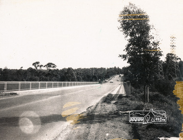
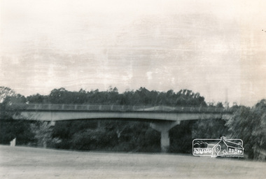
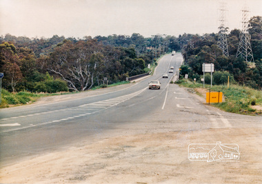
Photograph, Fitzsimons Lane Bridge over Yarra River between Eltham and Templestowe, c.1966, 1966c
... The Diamond Valley News (News clipping held in SEA_74-1_047) The previously un-named road between Main Road and Yarra River, Eltham South, east of Bolton Street was named Templestowe Road, December 15, 1970 NAMING OF STREETS AND ROADS. (1970, December 15). ...The Diamond Valley News (News clipping held in SEA_74-1_047) The previously un-named road between Main Road and Yarra River, Eltham South, east of Bolton Street was named Templestowe Road, December 15, 1970 NAMING OF STREETS AND ROADS. (1970, December 15). ...The bridge over the Yarra River was initially opened September 22nd, 1961. Newspaper reports at the time of opening stated it linked Bolton Street, Eltham, with Fitzsimons Lane, Templestowe. In 1955 the Country Roads Board (CRB) produced survey plans that showed proposed land acquisition for the future bridge and road approaches. The 1955 plan shows that it was proposed to connect Fitzsimons Lane with Bolton Street in Eltham by a diagonal road across the river. The road connection would then continue along Bolton Street to Main Road. Prior to construction of the bridge the CRB modified the proposal significantly so that there was a new road parallel with Bolton Street and then curving to join Main Road at what was then its intersection with Old Eltham Road. This involved significantly more land acquisition and altered the pattern of land subdivision through this corridor. Initially the new road was just a single two-way carriageway as it would have required a significant widening of the cutting on the Shire of Eltham side of the river. The road was officially un-named but was known locally as the Eltham-Templestowe Road. The 1966 Melway street directory and other 1960s editions also listed the road as the Eltham-Templestowe Road. In December 1970, Eltham Shire Council, in pursuance of the provisions of the Local Government Act, named it Templestowe Road. The road was renamed Fitzsimons Lane around 1984 in conformity with the section south of the river. In 1991 a new bridge was built to the west of the original bridge. Fitzsimons Lane was widened to four traffic lanes although on the Eltham side this was done within the limits of the existing cutting. NEW BRIDGE STARTS THEM EXPLORING Without any fanfares, Country Roads Board workmen on Friday afternoon put the finishing touches to the approaches, removed the barricades, and let the traffic roll over the new Yarra bridge linking Bolton Street, Eltham, with Fitzsimons Lane, Templestowe. Over the week-end many “bridge watchers” who were making one of their periodic inspections of the progress on the new bridge found to their surprise that they could drive over it, so that people who had gone for a run out to Eltham suddenly found themselves wandering through Templestowe and Doncaster. By Monday the word of the bridge’s opening had got around sufficiently for many regular travellers to the city from Eltham and beyond to vary the monotony by going to town via Templestowe and Kew instead of through Heidelberg. They were surprised at the distances – about 3 ½ miles from Eltham to Templestowe, 6 miles from Eltham Shire hall to the Lower Heidelberg Road-Banksia Street intersection. NEW NEIGHBOURS For people on both sides of the river, the new bridge has turned distant friends into near neighbours. A Greensborough man on Sunday took 35 minutes to reach the home of a friend in East Doncaster, but the return trip over the new bridge took only 17 minutes. It will be some time yet before most people work out the possibilities in shorter and quicker trips form the north-eastern areas to the eastern and south-eastern suburbs. The coming of the warmer months will soon teach many, though the short cuts to Peninsular beaches and eastern suburban drive-ins. And before very long it is likely there will be a Tramways bus running from Templestowe to Eltham station. NEW BRIDGE STARTS THEM EXPLORING (1961, September 27). The Diamond Valley News (News clipping held in SEA_74-1_047) The previously un-named road between Main Road and Yarra River, Eltham South, east of Bolton Street was named Templestowe Road, December 15, 1970 NAMING OF STREETS AND ROADS. (1970, December 15). The Diamond Valley News (News clipping held in SEA_74-2_022)Black and white photographManufacturer's marks: Polaroid, Batch #J62K181 (Sep 1966).infrastructure, shire of eltham infrastructure, bridge, fitzsimons lane bridge, polaroid, yarra river -
 Eltham District Historical Society Inc
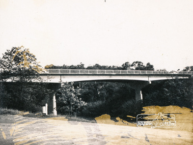
Photograph, Fitzsimons Lane Bridge over Yarra River between Eltham and Templestowe
... The Diamond Valley News (News clipping held in SEA_74-1_047) The previously un-named road between Main Road and Yarra River, Eltham South, east of Bolton Street was named Templestowe Road, December 15, 1970 NAMING OF STREETS AND ROADS. (1970, December 15). ...The Diamond Valley News (News clipping held in SEA_74-1_047) The previously un-named road between Main Road and Yarra River, Eltham South, east of Bolton Street was named Templestowe Road, December 15, 1970 NAMING OF STREETS AND ROADS. (1970, December 15). ...The bridge over the Yarra River was initially opened September 22nd, 1961. Newspaper reports at the time of opening stated it linked Bolton Street, Eltham, with Fitzsimons Lane, Templestowe. In 1955 the Country Roads Board (CRB) produced survey plans that showed proposed land acquisition for the future bridge and road approaches. The 1955 plan shows that it was proposed to connect Fitzsimons Lane with Bolton Street in Eltham by a diagonal road across the river. The road connection would then continue along Bolton Street to Main Road. Prior to construction of the bridge the CRB modified the proposal significantly so that there was a new road parallel with Bolton Street and then curving to join Main Road at what was then its intersection with Old Eltham Road. This involved significantly more land acquisition and altered the pattern of land subdivision through this corridor. Initially the new road was just a single two-way carriageway as it would have required a significant widening of the cutting on the Shire of Eltham side of the river. The road was officially un-named but was known locally as the Eltham-Templestowe Road. The 1966 Melway street directory and other 1960s editions also listed the road as the Eltham-Templestowe Road. In December 1970, Eltham Shire Council, in pursuance of the provisions of the Local Government Act, named it Templestowe Road. The road was renamed Fitzsimons Lane around 1984 in conformity with the section south of the river. In 1991 a new bridge was built to the west of the original bridge. Fitzsimons Lane was widened to four traffic lanes although on the Eltham side this was done within the limits of the existing cutting. NEW BRIDGE STARTS THEM EXPLORING Without any fanfares, Country Roads Board workmen on Friday afternoon put the finishing touches to the approaches, removed the barricades, and let the traffic roll over the new Yarra bridge linking Bolton Street, Eltham, with Fitzsimons Lane, Templestowe. Over the week-end many “bridge watchers” who were making one of their periodic inspections of the progress on the new bridge found to their surprise that they could drive over it, so that people who had gone for a run out to Eltham suddenly found themselves wandering through Templestowe and Doncaster. By Monday the word of the bridge’s opening had got around sufficiently for many regular travellers to the city from Eltham and beyond to vary the monotony by going to town via Templestowe and Kew instead of through Heidelberg. They were surprised at the distances – about 3 ½ miles from Eltham to Templestowe, 6 miles from Eltham Shire hall to the Lower Heidelberg Road-Banksia Street intersection. NEW NEIGHBOURS For people on both sides of the river, the new bridge has turned distant friends into near neighbours. A Greensborough man on Sunday took 35 minutes to reach the home of a friend in East Doncaster, but the return trip over the new bridge took only 17 minutes. It will be some time yet before most people work out the possibilities in shorter and quicker trips form the north-eastern areas to the eastern and south-eastern suburbs. The coming of the warmer months will soon teach many, though the short cuts to Peninsular beaches and eastern suburban drive-ins. And before very long it is likely there will be a Tramways bus running from Templestowe to Eltham station. NEW BRIDGE STARTS THEM EXPLORING (1961, September 27). The Diamond Valley News (News clipping held in SEA_74-1_047) The previously un-named road between Main Road and Yarra River, Eltham South, east of Bolton Street was named Templestowe Road, December 15, 1970 NAMING OF STREETS AND ROADS. (1970, December 15). The Diamond Valley News (News clipping held in SEA_74-2_022)Black and white photographinfrastructure, shire of eltham infrastructure, bridge, fitzsimons lane bridge, yarra river -
 Eltham District Historical Society Inc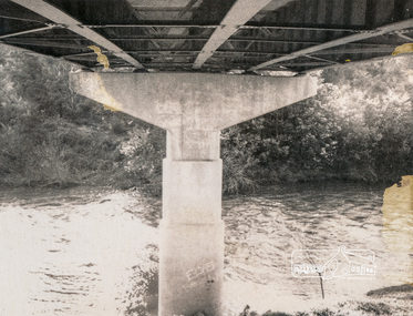
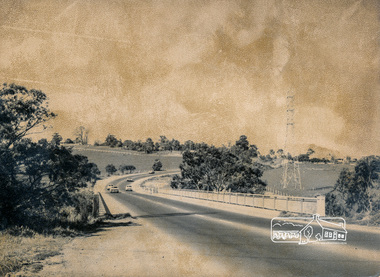
Photograph, Looking south across the Fitzsimons Lane Bridge over Yarra River between Eltham and Templestowe
... The Diamond Valley News (News clipping held in SEA_74-1_047) The previously un-named road between Main Road and Yarra River, Eltham South, east of Bolton Street was named Templestowe Road, December 15, 1970 NAMING OF STREETS AND ROADS. (1970, December 15). ...The Diamond Valley News (News clipping held in SEA_74-1_047) The previously un-named road between Main Road and Yarra River, Eltham South, east of Bolton Street was named Templestowe Road, December 15, 1970 NAMING OF STREETS AND ROADS. (1970, December 15). ...The bridge over the Yarra River was initially opened September 22nd, 1961. Newspaper reports at the time of opening stated it linked Bolton Street, Eltham, with Fitzsimons Lane, Templestowe. In 1955 the Country Roads Board (CRB) produced survey plans that showed proposed land acquisition for the future bridge and road approaches. The 1955 plan shows that it was proposed to connect Fitzsimons Lane with Bolton Street in Eltham by a diagonal road across the river. The road connection would then continue along Bolton Street to Main Road. Prior to construction of the bridge the CRB modified the proposal significantly so that there was a new road parallel with Bolton Street and then curving to join Main Road at what was then its intersection with Old Eltham Road. This involved significantly more land acquisition and altered the pattern of land subdivision through this corridor. Initially the new road was just a single two-way carriageway as it would have required a significant widening of the cutting on the Shire of Eltham side of the river. The road was officially un-named but was known locally as the Eltham-Templestowe Road. The 1966 Melway street directory and other 1960s editions also listed the road as the Eltham-Templestowe Road. In December 1970, Eltham Shire Council, in pursuance of the provisions of the Local Government Act, named it Templestowe Road. The road was renamed Fitzsimons Lane around 1984 in conformity with the section south of the river. In 1991 a new bridge was built to the west of the original bridge. Fitzsimons Lane was widened to four traffic lanes although on the Eltham side this was done within the limits of the existing cutting. NEW BRIDGE STARTS THEM EXPLORING Without any fanfares, Country Roads Board workmen on Friday afternoon put the finishing touches to the approaches, removed the barricades, and let the traffic roll over the new Yarra bridge linking Bolton Street, Eltham, with Fitzsimons Lane, Templestowe. Over the week-end many “bridge watchers” who were making one of their periodic inspections of the progress on the new bridge found to their surprise that they could drive over it, so that people who had gone for a run out to Eltham suddenly found themselves wandering through Templestowe and Doncaster. By Monday the word of the bridge’s opening had got around sufficiently for many regular travellers to the city from Eltham and beyond to vary the monotony by going to town via Templestowe and Kew instead of through Heidelberg. They were surprised at the distances – about 3 ½ miles from Eltham to Templestowe, 6 miles from Eltham Shire hall to the Lower Heidelberg Road-Banksia Street intersection. NEW NEIGHBOURS For people on both sides of the river, the new bridge has turned distant friends into near neighbours. A Greensborough man on Sunday took 35 minutes to reach the home of a friend in East Doncaster, but the return trip over the new bridge took only 17 minutes. It will be some time yet before most people work out the possibilities in shorter and quicker trips form the north-eastern areas to the eastern and south-eastern suburbs. The coming of the warmer months will soon teach many, though the short cuts to Peninsular beaches and eastern suburban drive-ins. And before very long it is likely there will be a Tramways bus running from Templestowe to Eltham station. NEW BRIDGE STARTS THEM EXPLORING (1961, September 27). The Diamond Valley News (News clipping held in SEA_74-1_047) The previously un-named road between Main Road and Yarra River, Eltham South, east of Bolton Street was named Templestowe Road, December 15, 1970 NAMING OF STREETS AND ROADS. (1970, December 15). The Diamond Valley News (News clipping held in SEA_74-2_022)Black and white photographinfrastructure, shire of eltham infrastructure, bridge, fitzsimons lane bridge, yarra river -
 Eltham District Historical Society Inc
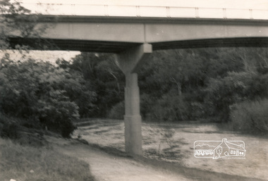
Photograph, Fitzsimons Lane Bridge over Yarra River between Eltham and Templestowe
... The Diamond Valley News (News clipping held in SEA_74-1_047) The previously un-named road between Main Road and Yarra River, Eltham South, east of Bolton Street was named Templestowe Road, December 15, 1970 NAMING OF STREETS AND ROADS. (1970, December 15). ...The Diamond Valley News (News clipping held in SEA_74-1_047) The previously un-named road between Main Road and Yarra River, Eltham South, east of Bolton Street was named Templestowe Road, December 15, 1970 NAMING OF STREETS AND ROADS. (1970, December 15). ...The bridge over the Yarra River was initially opened September 22nd, 1961. Newspaper reports at the time of opening stated it linked Bolton Street, Eltham, with Fitzsimons Lane, Templestowe. In 1955 the Country Roads Board (CRB) produced survey plans that showed proposed land acquisition for the future bridge and road approaches. The 1955 plan shows that it was proposed to connect Fitzsimons Lane with Bolton Street in Eltham by a diagonal road across the river. The road connection would then continue along Bolton Street to Main Road. Prior to construction of the bridge the CRB modified the proposal significantly so that there was a new road parallel with Bolton Street and then curving to join Main Road at what was then its intersection with Old Eltham Road. This involved significantly more land acquisition and altered the pattern of land subdivision through this corridor. Initially the new road was just a single two-way carriageway as it would have required a significant widening of the cutting on the Shire of Eltham side of the river. The road was officially un-named but was known locally as the Eltham-Templestowe Road. The 1966 Melway street directory and other 1960s editions also listed the road as the Eltham-Templestowe Road. In December 1970, Eltham Shire Council, in pursuance of the provisions of the Local Government Act, named it Templestowe Road. The road was renamed Fitzsimons Lane around 1984 in conformity with the section south of the river. In 1991 a new bridge was built to the west of the original bridge. Fitzsimons Lane was widened to four traffic lanes although on the Eltham side this was done within the limits of the existing cutting. NEW BRIDGE STARTS THEM EXPLORING Without any fanfares, Country Roads Board workmen on Friday afternoon put the finishing touches to the approaches, removed the barricades, and let the traffic roll over the new Yarra bridge linking Bolton Street, Eltham, with Fitzsimons Lane, Templestowe. Over the week-end many “bridge watchers” who were making one of their periodic inspections of the progress on the new bridge found to their surprise that they could drive over it, so that people who had gone for a run out to Eltham suddenly found themselves wandering through Templestowe and Doncaster. By Monday the word of the bridge’s opening had got around sufficiently for many regular travellers to the city from Eltham and beyond to vary the monotony by going to town via Templestowe and Kew instead of through Heidelberg. They were surprised at the distances – about 3 ½ miles from Eltham to Templestowe, 6 miles from Eltham Shire hall to the Lower Heidelberg Road-Banksia Street intersection. NEW NEIGHBOURS For people on both sides of the river, the new bridge has turned distant friends into near neighbours. A Greensborough man on Sunday took 35 minutes to reach the home of a friend in East Doncaster, but the return trip over the new bridge took only 17 minutes. It will be some time yet before most people work out the possibilities in shorter and quicker trips form the north-eastern areas to the eastern and south-eastern suburbs. The coming of the warmer months will soon teach many, though the short cuts to Peninsular beaches and eastern suburban drive-ins. And before very long it is likely there will be a Tramways bus running from Templestowe to Eltham station. NEW BRIDGE STARTS THEM EXPLORING (1961, September 27). The Diamond Valley News (News clipping held in SEA_74-1_047) The previously un-named road between Main Road and Yarra River, Eltham South, east of Bolton Street was named Templestowe Road, December 15, 1970 NAMING OF STREETS AND ROADS. (1970, December 15). The Diamond Valley News (News clipping held in SEA_74-2_022)Black and white photographinfrastructure, shire of eltham infrastructure, bridge, fitzsimons lane bridge, yarra river -
 Eltham District Historical Society Inc
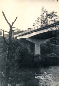
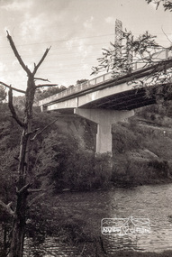
Photograph, Looking north across the Fitzsimons Lane Bridge over Yarra River between Eltham and Templestowe, c.1985, 1985c
... The Diamond Valley News (News clipping held in SEA_74-1_047) The previously un-named road between Main Road and Yarra River, Eltham South, east of Bolton Street was named Templestowe Road, December 15, 1970 NAMING OF STREETS AND ROADS. (1970, December 15). ...The Diamond Valley News (News clipping held in SEA_74-1_047) The previously un-named road between Main Road and Yarra River, Eltham South, east of Bolton Street was named Templestowe Road, December 15, 1970 NAMING OF STREETS AND ROADS. (1970, December 15). ...Turnoff to Candlebark Park on right. The bridge over the Yarra River was initially opened September 22nd, 1961. Newspaper reports at the time of opening stated it linked Bolton Street, Eltham, with Fitzsimons Lane, Templestowe. In 1955 the Country Roads Board (CRB) produced survey plans that showed proposed land acquisition for the future bridge and road approaches. The 1955 plan shows that it was proposed to connect Fitzsimons Lane with Bolton Street in Eltham by a diagonal road across the river. The road connection would then continue along Bolton Street to Main Road. Prior to construction of the bridge the CRB modified the proposal significantly so that there was a new road parallel with Bolton Street and then curving to join Main Road at what was then its intersection with Old Eltham Road. This involved significantly more land acquisition and altered the pattern of land subdivision through this corridor. Initially the new road was just a single two-way carriageway as it would have required a significant widening of the cutting on the Shire of Eltham side of the river. The road was officially un-named but was known locally as the Eltham-Templestowe Road. The 1966 Melway street directory and other 1960s editions also listed the road as the Eltham-Templestowe Road. In December 1970, Eltham Shire Council, in pursuance of the provisions of the Local Government Act, named it Templestowe Road. The road was renamed Fitzsimons Lane around 1984 in conformity with the section south of the river. In 1991 a new bridge was built to the west of the original bridge. Fitzsimons Lane was widened to four traffic lanes although on the Eltham side this was done within the limits of the existing cutting. NEW BRIDGE STARTS THEM EXPLORING Without any fanfares, Country Roads Board workmen on Friday afternoon put the finishing touches to the approaches, removed the barricades, and let the traffic roll over the new Yarra bridge linking Bolton Street, Eltham, with Fitzsimons Lane, Templestowe. Over the week-end many “bridge watchers” who were making one of their periodic inspections of the progress on the new bridge found to their surprise that they could drive over it, so that people who had gone for a run out to Eltham suddenly found themselves wandering through Templestowe and Doncaster. By Monday the word of the bridge’s opening had got around sufficiently for many regular travellers to the city from Eltham and beyond to vary the monotony by going to town via Templestowe and Kew instead of through Heidelberg. They were surprised at the distances – about 3 ½ miles from Eltham to Templestowe, 6 miles from Eltham Shire hall to the Lower Heidelberg Road-Banksia Street intersection. NEW NEIGHBOURS For people on both sides of the river, the new bridge has turned distant friends into near neighbours. A Greensborough man on Sunday took 35 minutes to reach the home of a friend in East Doncaster, but the return trip over the new bridge took only 17 minutes. It will be some time yet before most people work out the possibilities in shorter and quicker trips form the north-eastern areas to the eastern and south-eastern suburbs. The coming of the warmer months will soon teach many, though the short cuts to Peninsular beaches and eastern suburban drive-ins. And before very long it is likely there will be a Tramways bus running from Templestowe to Eltham station. NEW BRIDGE STARTS THEM EXPLORING (1961, September 27). The Diamond Valley News (News clipping held in SEA_74-1_047) The previously un-named road between Main Road and Yarra River, Eltham South, east of Bolton Street was named Templestowe Road, December 15, 1970 NAMING OF STREETS AND ROADS. (1970, December 15). The Diamond Valley News (News clipping held in SEA_74-2_022)Colour photographinfrastructure, shire of eltham infrastructure, bridge, fitzsimons lane bridge, yarra river, candlebark park, red nose day -
 Eltham District Historical Society Inc
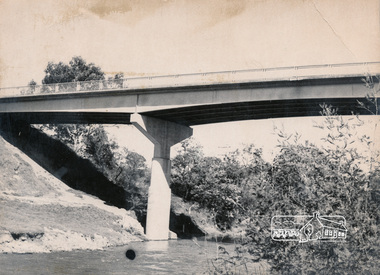
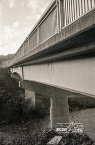
Photograph, Russell Yeoman, Fitzsimons Lane Bridge over Yarra River between Eltham and Templestowe, c.1970, 1970c
... The Diamond Valley News (News clipping held in SEA_74-1_047) The previously un-named road between Main Road and Yarra River, Eltham South, east of Bolton Street was named Templestowe Road, December 15, 1970 NAMING OF STREETS AND ROADS. (1970, December 15). ...The Diamond Valley News (News clipping held in SEA_74-1_047) The previously un-named road between Main Road and Yarra River, Eltham South, east of Bolton Street was named Templestowe Road, December 15, 1970 NAMING OF STREETS AND ROADS. (1970, December 15). ...The bridge over the Yarra River was initially opened September 22nd, 1961. Newspaper reports at the time of opening stated it linked Bolton Street, Eltham, with Fitzsimons Lane, Templestowe. In 1955 the Country Roads Board (CRB) produced survey plans that showed proposed land acquisition for the future bridge and road approaches. The 1955 plan shows that it was proposed to connect Fitzsimons Lane with Bolton Street in Eltham by a diagonal road across the river. The road connection would then continue along Bolton Street to Main Road. Prior to construction of the bridge the CRB modified the proposal significantly so that there was a new road parallel with Bolton Street and then curving to join Main Road at what was then its intersection with Old Eltham Road. This involved significantly more land acquisition and altered the pattern of land subdivision through this corridor. Initially the new road was just a single two-way carriageway as it would have required a significant widening of the cutting on the Shire of Eltham side of the river. The road was officially un-named but was known locally as the Eltham-Templestowe Road. The 1966 Melway street directory and other 1960s editions also listed the road as the Eltham-Templestowe Road. In December 1970, Eltham Shire Council, in pursuance of the provisions of the Local Government Act, named it Templestowe Road. The road was renamed Fitzsimons Lane around 1984 in conformity with the section south of the river. In 1991 a new bridge was built to the west of the original bridge. Fitzsimons Lane was widened to four traffic lanes although on the Eltham side this was done within the limits of the existing cutting. NEW BRIDGE STARTS THEM EXPLORING Without any fanfares, Country Roads Board workmen on Friday afternoon put the finishing touches to the approaches, removed the barricades, and let the traffic roll over the new Yarra bridge linking Bolton Street, Eltham, with Fitzsimons Lane, Templestowe. Over the week-end many “bridge watchers” who were making one of their periodic inspections of the progress on the new bridge found to their surprise that they could drive over it, so that people who had gone for a run out to Eltham suddenly found themselves wandering through Templestowe and Doncaster. By Monday the word of the bridge’s opening had got around sufficiently for many regular travellers to the city from Eltham and beyond to vary the monotony by going to town via Templestowe and Kew instead of through Heidelberg. They were surprised at the distances – about 3 ½ miles from Eltham to Templestowe, 6 miles from Eltham Shire hall to the Lower Heidelberg Road-Banksia Street intersection. NEW NEIGHBOURS For people on both sides of the river, the new bridge has turned distant friends into near neighbours. A Greensborough man on Sunday took 35 minutes to reach the home of a friend in East Doncaster, but the return trip over the new bridge took only 17 minutes. It will be some time yet before most people work out the possibilities in shorter and quicker trips form the north-eastern areas to the eastern and south-eastern suburbs. The coming of the warmer months will soon teach many, though the short cuts to Peninsular beaches and eastern suburban drive-ins. And before very long it is likely there will be a Tramways bus running from Templestowe to Eltham station. NEW BRIDGE STARTS THEM EXPLORING (1961, September 27). The Diamond Valley News (News clipping held in SEA_74-1_047) The previously un-named road between Main Road and Yarra River, Eltham South, east of Bolton Street was named Templestowe Road, December 15, 1970 NAMING OF STREETS AND ROADS. (1970, December 15). The Diamond Valley News (News clipping held in SEA_74-2_022)Roll of 35mm black and white negative film, 4 of 7 stripsIlford HP4bridge, bridges, fitzsimons lane bridge, infrastructure, shire of eltham infrastructure, yarra river -
 Eltham District Historical Society Inc
Photograph, Russell Yeoman, Fitzsimons Lane Bridge over Yarra River between Eltham and Templestowe, c.1970, 1970c
... The Diamond Valley News (News clipping held in SEA_74-1_047) The previously un-named road between Main Road and Yarra River, Eltham South, east of Bolton Street was named Templestowe Road, December 15, 1970 NAMING OF STREETS AND ROADS. (1970, December 15). ...The Diamond Valley News (News clipping held in SEA_74-1_047) The previously un-named road between Main Road and Yarra River, Eltham South, east of Bolton Street was named Templestowe Road, December 15, 1970 NAMING OF STREETS AND ROADS. (1970, December 15). ...The bridge over the Yarra River was initially opened September 22nd, 1961. Newspaper reports at the time of opening stated it linked Bolton Street, Eltham, with Fitzsimons Lane, Templestowe. In 1955 the Country Roads Board (CRB) produced survey plans that showed proposed land acquisition for the future bridge and road approaches. The 1955 plan shows that it was proposed to connect Fitzsimons Lane with Bolton Street in Eltham by a diagonal road across the river. The road connection would then continue along Bolton Street to Main Road. Prior to construction of the bridge the CRB modified the proposal significantly so that there was a new road parallel with Bolton Street and then curving to join Main Road at what was then its intersection with Old Eltham Road. This involved significantly more land acquisition and altered the pattern of land subdivision through this corridor. Initially the new road was just a single two-way carriageway as it would have required a significant widening of the cutting on the Shire of Eltham side of the river. The road was officially un-named but was known locally as the Eltham-Templestowe Road. The 1966 Melway street directory and other 1960s editions also listed the road as the Eltham-Templestowe Road. In December 1970, Eltham Shire Council, in pursuance of the provisions of the Local Government Act, named it Templestowe Road. The road was renamed Fitzsimons Lane around 1984 in conformity with the section south of the river. In 1991 a new bridge was built to the west of the original bridge. Fitzsimons Lane was widened to four traffic lanes although on the Eltham side this was done within the limits of the existing cutting. NEW BRIDGE STARTS THEM EXPLORING Without any fanfares, Country Roads Board workmen on Friday afternoon put the finishing touches to the approaches, removed the barricades, and let the traffic roll over the new Yarra bridge linking Bolton Street, Eltham, with Fitzsimons Lane, Templestowe. Over the week-end many “bridge watchers” who were making one of their periodic inspections of the progress on the new bridge found to their surprise that they could drive over it, so that people who had gone for a run out to Eltham suddenly found themselves wandering through Templestowe and Doncaster. By Monday the word of the bridge’s opening had got around sufficiently for many regular travellers to the city from Eltham and beyond to vary the monotony by going to town via Templestowe and Kew instead of through Heidelberg. They were surprised at the distances – about 3 ½ miles from Eltham to Templestowe, 6 miles from Eltham Shire hall to the Lower Heidelberg Road-Banksia Street intersection. NEW NEIGHBOURS For people on both sides of the river, the new bridge has turned distant friends into near neighbours. A Greensborough man on Sunday took 35 minutes to reach the home of a friend in East Doncaster, but the return trip over the new bridge took only 17 minutes. It will be some time yet before most people work out the possibilities in shorter and quicker trips form the north-eastern areas to the eastern and south-eastern suburbs. The coming of the warmer months will soon teach many, though the short cuts to Peninsular beaches and eastern suburban drive-ins. And before very long it is likely there will be a Tramways bus running from Templestowe to Eltham station. NEW BRIDGE STARTS THEM EXPLORING (1961, September 27). The Diamond Valley News (News clipping held in SEA_74-1_047) The previously un-named road between Main Road and Yarra River, Eltham South, east of Bolton Street was named Templestowe Road, December 15, 1970 NAMING OF STREETS AND ROADS. (1970, December 15). The Diamond Valley News (News clipping held in SEA_74-2_022)Roll of 35mm black and white negative film, 4 of 7 stripsIlford HP4bridge, bridges, fitzsimons lane bridge, infrastructure, shire of eltham infrastructure, yarra river -
 Port of Echuca
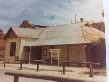
Colour photograph, 1979
... In 1890 Jane Pygall bought the hotel, which was described by the Riverine Herald as having ' three parlours, seven bedrooms, underground bar, kitchen, bathroom, outhouses, small stables, and entrance from two streets." She changed the name to The Esplanade Hotel. ...In 1890 Jane Pygall bought the hotel, which was described by the Riverine Herald as having ' three parlours, seven bedrooms, underground bar, kitchen, bathroom, outhouses, small stables, and entrance from two streets." She changed the name to The Esplanade Hotel. In 1890 it was de-licensed along with many hotels in Echuca. ...The Star Hotel was built in 1863 as a private dwelling, by James Shackell who owned the Bond Store, next door. It was a small house consisting of only a couple of rooms. In 1867 Joseph Salomon bought the house and converted it into a hotel. He built an underground bar to "deal with the peculiarities of the Echuca climate". It was called 'The Shades'. In 1890 Jane Pygall bought the hotel, which was described by the Riverine Herald as having ' three parlours, seven bedrooms, underground bar, kitchen, bathroom, outhouses, small stables, and entrance from two streets." She changed the name to The Esplanade Hotel. In 1890 it was de-licensed along with many hotels in Echuca. It had been a very popular drinking place for all the wharf workers, who continued to to drink illegally in the underground bar. It was then that the escape tunnel to the laneway was built , so the drinkers could escape the Police raids. For many years it was a private dwelling, or an office. In 1973 the City of Echuca bought the Star Hotel and resored it. At the time this photograph was taken it was the main tourist information centre for the Port of Echuca. It now operates as a hotel, serving meals and providing performance opportunities for musicians.The Star Hotel is very significant in Echuca's history due to its proximity to the Echuca Wharf. It was the closest bar to the wharf. Despite Jane Pygall trying to improve the quality of her clientele, the wharf drinkers preferred to drink at The Star Hotel, as the Bridge Hotel catered for more upmarket clientele. After de-licensing in 1897, the workers continued to drink at The Shades Bar and even put in place elaborate strategies to enable them to drink illegally there. It is now a large eating and entertainment site, and the public are still able to visit 'The Shades Bar'.A coloured photograph of the Star Hotel building in Murray Esplanade. The photograph is taken from the east side of the street. The Shackell's Bond Store can be seen on the left of the photograph. Printed on the back are the words, "This paper manufactured by Kodak". Also on the back is green Port of Echuca stamp. Written across the front of the Bond Store are the words 'World In Wax Museum.' On a sign outside the Star Hotel are the words, "Port Information Centre. Ticket Sales. Souvenirs . Star Hotel 1867."port of echuca, star hotel, shackell, james, salomon, joseph, pygall, jane, esplanade hotel, 1863, underground bar, the shades, de-licensing of echuca hotels -
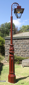 Flagstaff Hill Maritime Museum and Village
Functional object - Lamp Light, late 19th - early-20th century
... Bromfield Street in Warrnambool was named after the director of the gasworks, James Astley Bromfield (1823-1903). ...Bromfield Street in Warrnambool was named after the director of the gasworks, James Astley Bromfield (1823-1903). ...This gas lamp light and stand came from the original manufacturer in Melbourne. Gas street lights such as this one were used in Melbourne from the mid-19th century. The lights enabled safer after-dark travel for pedestrians and vehicles and were a deterrent to crime. A lamp lighter was employed to keep the lamps lit, sometimes with little success due to weather conditions and the pranks of youths. WARRNAMBOOL Gasworks In Warrnambool prior to 1874 there were about twenty rare, individually lit street lights in Warrnambool, each with its own supply of kerosene. These lamps were in the central business area of Timor, Koroit and Liebig Streets. The Warrnambool Gas Company Ltd. was registered as an incorporated company in 1873. It was a private, locally owned business. It was located at 209-215 Merri Street, Warrnambool, on the land, which is just west of the later-built railway station. The first managers of the Gas Company lived in a substantial stone house on site, but later the managers lived in a residence in Henna Street between Merri and Timor Streets. The original home, which still stands, became a residence for the Railway Station Master from about 1890. In August 1874 the construction of the gasworks was complete and at the end of that month gas was supplied to all of the existing lamps in Warrnambool for the first time. The Warrnambool Gas Company wound up in 1880-1881 and was purchased by the Warrnambool Borough Council with money raised by a loan – the Borough’s first ‘loan transaction’. The Council established a piped network to supply gas to other street connections. The gasworks were privatised and upgraded in 1952. In 1972 the town supply was converted to liquid petroleum gas and by the early 1980s the gasworks were closed down. In 1986 Warrnambool was supplied with natural gas from a site near Port Campbell. The Warrnambool gasworks supplied all street and shop lighting and most domestic lighting until 1923 when electricity was available for lighting. Bromfield Street in Warrnambool was named after the director of the gasworks, James Astley Bromfield (1823-1903). He arrived in Warrnambool from Worcestershire, England, in 1852 and was very active in the local council and community. Cockman Street was named after the first secretary of the gasworks in 1874, Walter Cockman (c.1821-1892). He was a Mayor and businessman. The second Manager, Luther Rodgers, worked for the gas company for about twenty years and both Rodger Place and Rodgers Road in Warrnambool have been named after him. LAMP LIGHTS IN MELBOURNE In the 1820s Melbourne's innkeepers were legally required to have a lamp light outside their premises from sunset to sunrise. This was the first instance of street lamps being used in Melbourne. In 1847 the first oil lamp was used in the city. In 1849 a gas lamp was installed on the Swanston Street Bridge and much of the city had oil lamps installed by then. In August 1857 the installation of street gas lamps began in Melbourne. They were welcomed for the much brighter illumination they gave. By 1860 there were 414 lamp pillars. The phrase was quoted often - "A light was as good as a policeman". The first gas burners used for street lighting were called 'fishtail' gas burners. These were replaced in the early 1900s by gas mantles. The City of Melbourne Gas Coke Company was formed in 1850 but due to the Gold Rush the manufacture and distribution of the gas supply was delayed until January 1856. By the 1890s the gas supplying the lights was supplied by three companies in Melbourne. In 1879 a football match was played at the MCG under electric lighting and gradually electric arc lights were installed inside and outside buildings in the city. Lamp lights such as the one in Flagstaff Hill’s collection were no longer needed. (References: John Lindsay re Lamp Light history 2019-01-29, Former Warrnambool Gas Company Limited, Victorian Heritage Database Report, Heritage Number 149746 https://vhd.heritagecouncil.vic.gov.au/places/149746/download-report ) The lamp light is representative of the lamps used in Melbourne from the mid-nineteenth century to light the streets at night and make Melbourne a safer city. The lamp is also representative of the gas street lighting in Warrnambool from the mid-1870s-1920s.Lamp light or gas light. Street light, one of the last gas street lights removed from Melbourne. (Reconditioned by Friends of Flagstaff Hill, 2013)flagstaff hill, warrnambool, shipwrecked coast, flagstaff hill maritime museum, maritime museum, shipwreck coast, flagstaff hill maritime village, great ocean road, lamp light, gas light, gas lamp, street lamp, street light, gas street light, melbourne street lighting, warrnambool street lighting, melbourne gas street light, warrnambool gas company, warrnambool gasworks, james bromfield, walter cockman, luther rodgers, city of melbourne gas coke company -
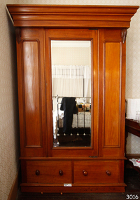 Flagstaff Hill Maritime Museum and Village
Furniture - Wardrobe, Late 19th to early 20th Century
... There is a street in Warrnambool named after the Swinton family. ...There is a street in Warrnambool named after the Swinton family. ...The original owner of the beautiful wardrobe was William Swinton Jr. (1860-1929) and was later given to a friend of the Giles family. It is part of the Giles Collection. William Swinton Jnr. was a Warrnambool Councilor 1903-20 and Mayor 1917-19, during which time Warrnambool declared a City (1918). William's father, William Swinton Snr. (c.1831-1901) arrived in Warrnambool in 1854 from Edinburgh, Scotland. He established the Swinton store in Timor Street in 1865 where it is still located. William Snr's grand-daughter, Doris Swinton (1904-1986) was one of Australia's most highly decorated nurses of World War 2 and for 16 years matron of the Warrnambool and District Base Hospital. There is a street in Warrnambool named after the Swinton family. The Giles Collection: There are many 19th century items of furniture, linen, and crockery donated to Flagstaff Hill Maritime Village by Vera and Aurelin Giles. The items are associated with the Giles Family and are known as the "Giles Collection". These items mostly came from the simple home of Vera's parents-in-law, Henry Giles and his wife Mary Jane (nee Freckleton), whose photos are in the parlour. They married in 1880. Henry Giles was born at Tower Hill in 1858. He was a labourer on the construction of the Breakwater before leaving in 1895 to build bridges in N.S.W. for about seven years. Mary Jane was born in 1860 at Cooramook. She attended Mailor's Flat State School where she was also a student teacher before, as a family legend has it, she became a governess at "Injemiara" where her grandfather, Francis Freckleton, once owned land. Henry and Mary’s family of six, some of whom were born at Mailor’s Flat and later children at Wangoom, lived with their parents at Wangoom and Purnim west, where Henry died in 1933 and Mary Jane in 1940. The wardrobe is also significant for its association with early Warrnambool history, being owned by William Swinton Jnr. who was a Warrnambool Councilor and Warrnambools first Mayor (1917-19) the son of an early colonial family, arriving in Warrnambool in 1854. The Giles family collection also has social significance at a local level, because it illustrates the level of material support the Warrnambool community gave to Flagstaff Hill when the Maritime Museum was established.Wardrobe, colonial, made of cedar wood. The doors of the wardrobe have a mirrored door between them and there are two large drawers below the doors, each drawer has two round wooden handles. The wardrobe was once owned by a William Swinton Jnr. It is now part of the Giles Collection.Noneflagstaff hill, warrnambool, shipwrecked-coast, maritime-museum, shipwreck-coast, flagstaff-hill-maritime-village, wardrobe, bedroom furniture, domestic furniture, william swinton jnr., warrnambool's first mayor, warrnambool mayor, giles collection, henry giles, tower hill, cooramook, warrnambool breakwater, mailor’s flat, wangoom, 19th century furniture, doris swinton, swinton street warrnambool -
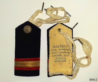 Flagstaff Hill Maritime Museum and Village
Badge - Epaulette, Harvey's Naval Outfitters, 1920s
... Another of the firm's addresses is Leadenhall Street, London, named the 'centre of commerce'. East India Company and Pacific & Oriental Steam Navigation Company (P&O) once had their headquarters there. ...Another of the firm's addresses is Leadenhall Street, London, named the 'centre of commerce'. East India Company and Pacific & Oriental Steam Navigation Company (P&O) once had their headquarters there. ...The pair of epaulettes once belonged to W.R. Angus, who possibly wore them when he worked his passage to and from the UK in the 1920s. The button on each has an unidentified emblem. They are part of Flagstaff Hill’s comprehensive W.R. Angus Collection, donated by the family of Dr W R Angus (1901-1970), surgeon and oculist. The ties, which look like shoe laces, would secure the epaulettes to the uniform's shoulders. The epaulettes were made by Harvey's Naval Outfitters of 15-16-17 London Street, London, E.C.3, in the East Central area of London. Another of the firm's addresses is Leadenhall Street, London, named the 'centre of commerce'. East India Company and Pacific & Oriental Steam Navigation Company (P&O) once had their headquarters there. The postcode 'EC3' dates back to 1917 when the postcode system was established in the United Kingdom. William Roy Angus (1901-1970) qualified as a doctor in 1923. He decided he further his studies overseas in the UK in 1927, sailing on the ship SS Banffshire (built in 1912, destroyed in 1937). He studied at London University College Hospital and Edinburgh Royal Infirmary and in 1928 he was awarded FRCS (Fellow from the Royal College of Surgeons), Edinburgh, Scotland. He worked his passage back to Australia as a Ship’s Surgeon on the Australian Commonwealth Line T.S.S. Largs Bay, purchased by the White Star Line in 1928. Dr W R Angus was a Surgeon Captain for the Australian Defence Forces, Army Medical Corps, stationed in Ballarat, Victoria, and in Bonegilla, N.S.W. He completed his service just before the end of the war due to suffering from a heart attack. The W.R. Angus Collection: - The W.R. Angus Collection includes historical medical equipment, surgical instruments and material belonging to Dr Edward Ryan and Dr Thomas Francis Ryan, (both of Nhill, Victoria) and Dr Angus’ own belongings. The Collection’s history spans the medical practices of the two Doctors Ryan, from 1885-1926 plus that of Dr Angus, up until 1969. It includes historical medical and surgical equipment and instruments from the doctors Edward and Thomas Ryan of Nhill, Victoria. Dr Angus married Gladys in 1927 at Ballarat, the nearest big city to Nhill where he began as a Medical Assistant. He was also Acting House surgeon at the Nhill hospital where their two daughters were born. During World War II He served as a Military Doctor in the Australian Defence Forces. Dr Angus and his family moved to Warrnambool in 1939, where Dr Angus operated his own medical practice. He later added the part-time Port Medical Officer responsibility and was the last person appointed to that position. Dr Angus and his wife were very involved in the local community, including the new Flagstaff Hill's planning stages and the gardens' layout. Dr Angus passed away in March 1970.This pair of epaulettes is connected to the badges in the W.R. Angus Collection. Dr W R Angus (1901-1970), surgeon and oculist, collected a range of badges and military objects including those he personally used during his time as Surgeon Captain in the Australian Defence Forces in World War II. The W.R. Angus Collection is significant for still being located at the site it is connected with, Doctor Angus being the last Port Medical Officer in Warrnambool. The Collection includes historical medical objects that date back to the late 1800s.Epaulette (pair of two), dark blue with red and gold horizontal stripes, with a gold-coloured button and woven white web ties. A tall rectangular shape with a point at the top. Made from a card base, covered by dark blue fabric and a hand-stitched lining of cream-coloured leather, stamped with the maker's details. The button has an inscripton and image. Made by Harvey's Outfitters in London. The button has images and text. The epaulettes belonged to Dr W R Angus and are now part of the W. R. Angus Collection.“HARVEYS’ / NAVAL OUTFITTERS / 15-16-17, London St / LONDON E.C.3. / TELEPHONE / ROYAL 3248” Button; Inscription and image [indecipherable] Button is embossed with images (anchor, serpent, flag) and text "B. 'G. "flagstaff hill, warrnambool, maritime village, maritime museum, shipwreck coast, great ocean road, flagstaff hill maritime museum and village, dr w r angus, w.r. angus collection, badge, insignia, badge collection, epaulettes, naval epaulettes, naval insignia, shoulder boards, ss banffshire, t.s.s. largs bay, uniform, harvey's naval outfitters, london street london -
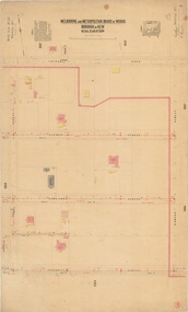 Kew Historical Society Inc
Plan, Melbourne & Metropolitan Board of Works : Borough of Kew : Detail Plan No.1568, 1905
... At the left of the plan, facing Sackville Street is a house named ‘Glencara’. The 1988 ‘Kew Conservation Study’ recorded that “The first documentary evidence of this house comes from Rate Books which record that in 1893 a Mrs Treadway was the owner of this building with an N.A.V. of £81? ...At the left of the plan, facing Sackville Street is a house named ‘Glencara’. The 1988 ‘Kew Conservation Study’ recorded that “The first documentary evidence of this house comes from Rate Books which record that in 1893 a Mrs Treadway was the owner of this building with an N.A.V. of £81? ...The Melbourne and Metropolitan Board of Works (MMBW) plans were produced from the 1890s to the 1950s. They were crucial to the design and development of Melbourne's sewerage and drainage system. The plans, at a scale of 40 feet to 1 inch (1:480), provide a detailed historical record of Melbourne streetscapes and environmental features. Each plan covers one or two street blocks (roughly six streets), showing details of buildings, including garden layouts and ownership boundaries, and features such as laneways, drains, bridges, parks, municipal boundaries and other prominent landmarks as they existed at the time each plan was produced. (Source: State Library of Victoria)This plan forms part of a large group of MMBW plans and maps that was donated to the Society by the Mr Poulter, City Engineer of the City of Kew in 1989. Within this collection, thirty-five hand-coloured plans, backed with linen, are of statewide significance as they include annotations that provide details of construction materials used in buildings in the first decade of the 20th century as well as additional information about land ownership and usage. The copies in the Public Record Office Victoria and the State Library of Victoria are monochrome versions which do not denote building materials so that the maps in this collection are invaluable and unique tools for researchers and heritage consultants. A number of the plans are not held in the collection of the State Library of Victoria so they have the additional attribute of rarity.Original survey plan, issued by the MMBW to a contractor with responsibility for constructing sewers in the area identified on the plan within the Borough of Kew. The plan was at some stage hand-coloured, possibly by the contractor, but more likely by officers working in the Engineering Department of the Borough and later Town, then City of Kew. The hand-coloured sections of buildings on the plan were used to denote masonry or brick constructions (pink), weatherboard constructions (yellow), and public buildings (grey). Plan No.1568 covers the area bounded by Cotham Road, John Street, Sackville Street, and Edward Street. Alfred Street and Rowland Street are in shown in the middle of the plan. The two most notable buildings shown are ‘St Helliers’, the home of the Dumaresq family, and St Hilary’s Church and school. While the colours used to indicate St Hilary’s are grey as in other civic/public buildings, the first St Hilary’s Anglican Church was at this stage constructed in weatherboard. At the left of the plan, facing Sackville Street is a house named ‘Glencara’. The 1988 ‘Kew Conservation Study’ recorded that “The first documentary evidence of this house comes from Rate Books which record that in 1893 a Mrs Treadway was the owner of this building with an N.A.V. of £81? At that date the occupier of the house was Charles B. Kelly, a clerk, while by 1910 Kelly had become the owner of the property described in that year ‘as a six-roomed stone, brick and wood house with stables and outbuildings’”. Contrary to this description, the 1905 plan indicates that the house was entirely constructed of masonry.melbourne and metropolitan board of works, detail plans, mmbw 1568 -
 Wodonga & District Historical Society Inc
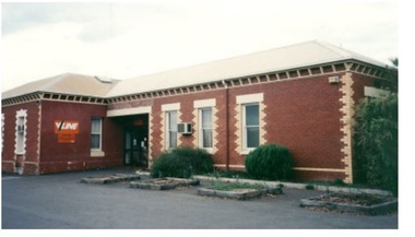
Photograph - Wodonga old Railway Station complex
... The location of the railway tracks and station were a constant cause of congestion in the centre of Wodonga as the tracks crossed over Sydney Road (later named High Street). Lines of traffic were frequently banked up as the gates were closed to allow trains to cross. ...The location of the railway tracks and station were a constant cause of congestion in the centre of Wodonga as the tracks crossed over Sydney Road (later named High Street). Lines of traffic were frequently banked up as the gates were closed to allow trains to cross. ...\When the railway reached Wodonga from Melbourne on 19th November 1873 the first station building, which included a refreshment room and dining room, was a temporary structure. It was 300 ft. long and was removed and taken to Beechworth when the new station was built in 1874 by contractor J. Richardson. The Goods shed was 100 feet long and was built by Frew & Hill in 1873. One year later it was extended an additional 150 feet by James Nation. The date of the construction of the Locomotive shed is not known but predates 1883. It was a galvanised iron clad building which housed 4 engines on 2 tracks; in 1910 it was extended to 250 feet in length to house six more engines. The location of the railway tracks and station were a constant cause of congestion in the centre of Wodonga as the tracks crossed over Sydney Road (later named High Street). Lines of traffic were frequently banked up as the gates were closed to allow trains to cross. The Wodonga Rail Bypass project moved Wodonga station from the original central location to a position on a new line on the northern edge of the town. Not only did this release land in the middle of the city for commercial and public use, but also eliminated 10 level crossings. The project actually commenced in 2008 with the last passenger train passing through Wodonga on 8 November 2008. On 23 July 2010, the new rail bypass was opened, the original line through Wodonga closed and the station fell quiet. The area has now been redeveloped as Junction Place and the old buildings now house a restaurant, cafe and the Goods Shed Craft Beer Cafe.These images are of local, state and national significance as the Wodonga Railway complex formed a vital link in the Victorian state, interstate and national railway system.A collection of colour photos of the buildings at the former Wodonga Railway Stationwodonga railways, railway station wodonga, junction place wodonga -
 Supreme Court of Victoria Library
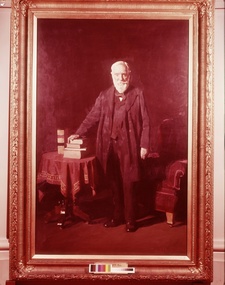
Portrait, John Schutt, Supreme Court Librarian, 1916/1917
... Away from the Court he was a councillor of many years standing in Williamstown, representing the Victoria Ward, what is now the suburb of Newport, it would appear Schutt street in Newport was named after him. His eldest son William Schutt was appointed a Supreme Court judge in 1919. ...Away from the Court he was a councillor of many years standing in Williamstown, representing the Victoria Ward, what is now the suburb of Newport, it would appear Schutt street in Newport was named after him. His eldest son William Schutt was appointed a Supreme Court judge in 1919. ...This portrait was presented by the Victorian Bar to the Library in 1917 to commemorate Schutt’s fifty years as the Supreme Court Librarian. The portrait was presented at a ceremony presided over by Mr Mitchell KC who noted the “unanimity with which the members of the profession had adopted the suggestion that the eminent services of Mr Schutt should be recognised in this way.” Chief Justice Madden also spoke on this occasion and there were a number of judges and members of the legal profession present. John Schutt had been born in England in 1831 and migrated to Victoria as a young man, initially working as a school teacher he was appointed librarian, during Redmond Barry’s time in 1866. He started work in the Old Court in Russell street and would have supervised the move of the library to its new and greatly expanded premises in William Street in 1884. As well as secretary to the Library committee, he also acted as the Secretary of the Board of Examiners on occasion. After his death in 1919 in its obituary, the Williamstown Chronicle noted that Schutt was regarded as a Solon, an ancient greek law giver who gave wise advice. Away from the Court he was a councillor of many years standing in Williamstown, representing the Victoria Ward, what is now the suburb of Newport, it would appear Schutt street in Newport was named after him. His eldest son William Schutt was appointed a Supreme Court judge in 1919. The portrait of Schutt is a companion piece to the Sir Thomas a’Beckett picture painted shortly before the Schutt portrait and for the same client, they share the same frame design with gum leaf motif. This portrait was undertaken early in Meldrum’s career and before he had fully developed his theory of painting. Duncan Max Meldrum (1875-1955) was a controversial figure in his later years as he strongly opposed modernism and non-figurative art. His works are found in most of the state galleries, including a wide selection at the National Gallery of Victoria. This portrait is of interest for whom it portrays and as the work of a well known artistFull length portrait in oils of John Schutt. Schutt is standing up looking out the to the viewer. His hand rests on a small pile of books. He is dressed soberly in a three piece black suit. His white beard and hair all meticulously trimmed and realised. The props used in this painting provide the main colour as the background has become dark over the years. The books sit atop of a red and gold draped table. Behind Schutt is what appears to be a crimson velvet chair and he gives every appearence of having just arisen from the chair to engage with the viewer. The painting has an unusual light source at the foot of the painting with Schutt's legs providing shadows. Signed Meldrum lower right hand corner. Plaque inscription is John Schutt, Esq. Supreme Court Librarian -
 Bendigo Historical Society Inc.
Book - CITY OF BENDIGO HISTORICAL WALK BOOK, 2001
... Gold for the year, 1853 November 31st Bendigo Hospital admits first patient,1853 December 9th Bendigo Advertiser first issue printed, 1854 First Land Sales and streets are surveyed and named for the first time, 1854 Census of Bendigo showed 15,480 residents plus 4,000 Chinese, 1855 Sandhurst Municipal District formed, 1861 Sandhurst Proclaimed a Town. 1862 Railway to Melbourne opened, 1867 Visit by His Royal Highness the Duke of Edinburgh, 1871 July 21st Sandhurst proclaimed a City, 1881 Population of Sandhurst 14,577 residents, 1882 First telephone communications introduced, 1890 Electric trams (battery) commenced running, 1891 May 18th City of Sandhurst changes its name to City of Bendigo....Gold for the year, 1853 November 31st Bendigo Hospital admits first patient,1853 December 9th Bendigo Advertiser first issue printed, 1854 First Land Sales and streets are surveyed and named for the first time, 1854 Census of Bendigo showed 15,480 residents plus 4,000 Chinese, 1855 Sandhurst Municipal District formed, 1861 Sandhurst Proclaimed a Town. 1862 Railway to Melbourne opened, 1867 Visit by His Royal Highness the Duke of Edinburgh, 1871 July 21st Sandhurst proclaimed a City, 1881 Population of Sandhurst 14,577 residents, 1882 First telephone communications introduced, 1890 Electric trams (battery) commenced running, 1891 May 18th City of Sandhurst changes its name to City of Bendigo. ...Photocopy mock up of original booklet of The Bendigo Historical Society Inc. 'City of Bendigo Historical Walk' containing photographs of historic buildings to be seen on the walk. Front cover Queen Victorian Gardens, Town hall, Mechanics Institute/School Of Mines and Industry, H. M. Prison Bendigo, Camp Hill Police Barracks, Sandhurst Corporate High School, Central State School No. 1976, The Cascades, District Lands Office (Dudley House), Masonic Temple and Hall, Sandhurst Volunteer Rifle Brigade Orderly Room, Bank of Victoria, Henry Jackson's Store View Point,Alexandra Fountain, Beehive Store/Mining Exchange, Colonial Bank. Hustlers Royal Reserve NO. 2/R.S.L. Memorial Hall, Post Office 3rd 4th and final, Bendigo Law Courts, Shamrock Hotel 2nd and another view. Important Bendigo Dates; 1851, April gold discovered at Golden Square by Margaret Kennedy,1851 Approx. 200,000Troy oz. of gold found in Bendigo, 1852 475,857 Troy oz. Gold for the year, 1853 November 31st Bendigo Hospital admits first patient,1853 December 9th Bendigo Advertiser first issue printed, 1854 First Land Sales and streets are surveyed and named for the first time, 1854 Census of Bendigo showed 15,480 residents plus 4,000 Chinese, 1855 Sandhurst Municipal District formed, 1861 Sandhurst Proclaimed a Town. 1862 Railway to Melbourne opened, 1867 Visit by His Royal Highness the Duke of Edinburgh, 1871 July 21st Sandhurst proclaimed a City, 1881 Population of Sandhurst 14,577 residents, 1882 First telephone communications introduced, 1890 Electric trams (battery) commenced running, 1891 May 18th City of Sandhurst changes its name to City of Bendigo.book, bendigo, buildings, historic -
 Sunshine and District Historical Society Incorporated
Album - Sunshine Advocate and Brimbank Messenger Newspaper Cuttings 1998 - 2010 Scrapbook, 1998-2001
... Paraskeve|Western Ring Road traffic|Joseph & Frances Testa|Sydneham Kimgdom Hall of Jehovah's Witnesses|Sydenham The Assemblies of God|Michael & Rosalia Skok|Werribee's State Rose Gardens|Tom & Maria Diele|Tom Rigg and the origin of the district's street names|Sunshine & St. Albans Baptist Church|ICI Estate protest|Sunshine Salvation Army Church|Macedonian Orthodox Church|Anita-Marie Neumann|Albanvale path of recongnition|Sunshine Pool action group|Minnie Gorsuch|State Election 2000|Jean Folry & Ilma Weir|Brimbank Uniting Church|Harvester Town book launch - Olwen Ford|Brooke Jujinovic|Keilor Cemetery grave stones|John Howard ignores Braybrook|Norman & Joan Wales|Clare Brennan Drive named after Clare Brennan|Fosseys Sunshine closure|Commonwealth Bank (CBA) Glengala Road closuer|James Frederick McKay|A history of Sunshine|H.V. ...Paraskeve|Western Ring Road traffic|Joseph & Frances Testa|Sydneham Kimgdom Hall of Jehovah's Witnesses|Sydenham The Assemblies of God|Michael & Rosalia Skok|Werribee's State Rose Gardens|Tom & Maria Diele|Tom Rigg and the origin of the district's street names|Sunshine & St. Albans Baptist Church|ICI Estate protest|Sunshine Salvation Army Church|Macedonian Orthodox Church|Anita-Marie Neumann|Albanvale path of recongnition|Sunshine Pool action group|Minnie Gorsuch|State Election 2000|Jean Folry & Ilma Weir|Brimbank Uniting Church|Harvester Town book launch - Olwen Ford|Brooke Jujinovic|Keilor Cemetery grave stones|John Howard ignores Braybrook|Norman & Joan Wales|Clare Brennan Drive named after Clare Brennan|Fosseys Sunshine closure|Commonwealth Bank (CBA) Glengala Road closuer|James Frederick McKay|A history of Sunshine|H.V. ...These scrap books were put together by Tom Riggs, a past St. Albans Train Station Master, St. Albans Centenary Committee & Sunshine & District Historical Society member and they record a history of a wide range of subjects referring to the Sunshine & District. The following list is only a brief description of each scrapbook. 663.01 - People in official postions 1908|H.V. McKay Factory Gates|Part layout in vicinity of Sunshine Railway Station map 1910|Sunshine Station Signal Box|Harvester Museum|H.V. McKay|H.V. McKay Bulk Store|Sunshine's colorful history|Family of Nathaniel & Mary McKay family tree|Sunshine Smithy|Braybrook residents 1903 & 1906 Sands & McDougal listing|Nat & Joyce Wright|Sunshine Market Palce|Sunshine new police station|Sunshine new post office|S&DHS newspaper articles|Black Powder Mill|Deer Park St. John's Anglican Church|Robert Eric Parsons|Rubblish dumping issue|Bob & Cyril Parsons|Deer Park Bypass|Sunshine Leisure Centre|Sunshine Station Interchange|Dorothy Price|Sunshine Hospital expansion|Albert & Amy Russell|Wally O'Brien|Hospital pedestrain crossing|Our Lady's Primary School reunion|Mytle Baylis|Darling Albion Flour Mill|Pokie machines|Harricks Cottage|Jack Tighe|Cr Brooke Gujinovic New Brimank Mayor|Jack Collins|Isabella Williams Reserve|Cairnlea developement|Albert Holden|Old Sunsine Police Station Sun Crescent|Big bins|Phyllis Vance|Sunshine Pipe Band|Dick & Elsie Whiting|Historic house denmiolition|Boom gate deley|Brian & Doreen Duffy|Beth Argyle|Sunshine Railway Disaster|Les Hunter|Sunshine Pool closure protest|Clare Brennan|Mickey Vautier|Jack Sheridan|Balam Balam Reserve|Gwen Goedecke|Derrimut Hotel & licensee Wal Elms|Jimmy Gaylor|John & Leone Hawking|Centrelink move|Joan Carstairs|Hampshire Road roadworks|Lloyd McCallum postman retires|Mavis Kittelty & Sunshine Croquet Club closes|Frank O'Connor|Beth Argyle, Don Deeble, Shirley Wallace & Jack Sheridan|Sunshine Anglican Church & Father Stuart Soley|Ian Baker|Morris Street proposed flat development protest|Brimbank's rich cultural history|Church of Christ|Doreen Foster & Albion Tennis Club|Francis & Lillian Allen|Sunshine Wesleyan Methodist Churst|3LO-3AR radio transmitter|George & Gloria Hales|H.V. McKay Medal Trade Wing|Lorna Cameron|Noala Flynn|St. Ablans Baptist Church & Ralph Phillips|Apostolic Christian Church|Keilor Christian City Church|Sunshine City Band|Maidstone Our Ladys of Perpetual Church|Waterways|Ron & Margaret Craker 663.02 - Black Powder Mill|St. Albans Greek Orthodox Church of St. Paraskeve|Western Ring Road traffic|Joseph & Frances Testa|Sydneham Kimgdom Hall of Jehovah's Witnesses|Sydenham The Assemblies of God|Michael & Rosalia Skok|Werribee's State Rose Gardens|Tom & Maria Diele|Tom Rigg and the origin of the district's street names|Sunshine & St. Albans Baptist Church|ICI Estate protest|Sunshine Salvation Army Church|Macedonian Orthodox Church|Anita-Marie Neumann|Albanvale path of recongnition|Sunshine Pool action group|Minnie Gorsuch|State Election 2000|Jean Folry & Ilma Weir|Brimbank Uniting Church|Harvester Town book launch - Olwen Ford|Brooke Jujinovic|Keilor Cemetery grave stones|John Howard ignores Braybrook|Norman & Joan Wales|Clare Brennan Drive named after Clare Brennan|Fosseys Sunshine closure|Commonwealth Bank (CBA) Glengala Road closuer|James Frederick McKay|A history of Sunshine|H.V. McKay's Russell Street gates|Barry McMahon|Sunshine Swimming Pool Aquatic centre sale|Keith Buckley|Migrants' move to brave new world|Vasilos & Eugenia Karaoglandis|William Hyett|Darryl Myers|Kathleen Inkster|Sunshine RSL Kevin Keegan, Kevin Bryar & Fred Russell|Barney & Renee Cater|Mona Malouf|George Carter|Sunshine Pottery memorabilia & reunion|Des Johnson Duke Street Aborigine artifacts|Albert Drayton|Two pools planned|Sunshine Pool repairs approved|Olympic Tooch journey through Brimbank|Maurice & Kathleen Sanders|Paul & Suzanna Vicek|Deer Park By Pass Road|Bert & Noreen Craddock|St. Albans Legless Lizards under fire|Sunshine rare orchid scare|St. Albans Road black spot|Viet name for Burke street|Russell Street gates unveiling ceremony|Don & Val Byrnes|Emily Hall|Sunshine Swim centre|Water action plans|Melton Highway sugar gum tree removal by Vicroads|Sunshine Police Station Olympic Rings Brick|Emmaus Catholic School Sydenham opening|Black Powder Mill|Stevens Farm House fire|Yvonne Flack|Frank Gathercole|Commonwealth Bank closurer|Marion Martin|Deer Park State School|Tom & Flo Beagley|Call for railway land buffer|Clarrie Salvador|Braybrook Hotel|Sunshine Harvester Smithy|2000, A year to remember|Bus Re-route hits traders|Sunshine Swimming Pool end of life|Pam Chapman|Prune Goldrick - When the Whistle Blew|Wally O'Brien recalls Deer Park during his childhood|Western Highway / Ballarat Road traffic|Tom Rigg confusing St. Albans bus signs|Rubbish in Deer Park|Phyllis Frost|Basil Morcos|Allan "Titch" Williams|George Thoms|Clarrie Salvator|Tom Dile|Igor Balabin|John McArdie|Sam & Rita Attard|Jack & Dorothy Roberts|Joe De Gabriele|Beth Argyle|John Refshauge surgeon|Bill Fogarity|Brimbank Heritage Listing in peril|Museum of Victoria virtually tour of H.V. McHarvester Factory|Jock McLeod|John & lorna Stainer|Rita Shimmin|Smithy|Nettlefolds - Len Duxon, Betty Scott, Frank Richards, Thelma Burnett, Reg Ratcliffe & Frank Farrugia|Emma Broadhead|Bill Bunting|Gwen Goedecke|Ron Dorre|Sunshine Hospital Redevelopment|Braybrook Squash Centre|Megan Blair|Harvester Town book launch|Tom Rigg rail safty activist|Lloyd & Gislaine Simpson|Sunshine's past revealed|Legless Lizards site Jones Creek|Wetlands|St. Albans time capsule|Cainlea suburb name causing a stir|Agnes Clark|Norman de Pomeroy|Ern & Dot Nicholls|Anton & Maria Gerber|Peter & Margaret McManus|H.V. McKay Offices heritage listing|Cr. Chris Evans out|Two historial walks in Sunshine|Brink Back the H.V. McKay Smithy opening invite|Counicl destroys old files|Harricks Cottage|Special Exhibution Models of Sunshine made farn implements exhibition invite 663.03 - Wally O'Brien|Cr. Chris Evans|Sunshine pool debate|Black Powder Mill|Sydnenham / Hillside Primary School name changes|Say goodbye to Sydnenham, Watergardens|Spalding Reuion|Harry Unger|Gwen Goedecke|Frances Fitzgerald|Preerving Brimbank's significant landmarks|Bernard Reilly kindergarten train|Albert Holden|St. Peters Channel Catholic Church|Terry Muscat|Smithy|Norman & Geoff Pomeroy|Sunshine disaster recalled|Sydneham Railway Station|Sunshine Baseball Club|Albert Evans|Sunshine Pool anger|Albion car crash|Jackson School to loose portables|Black Powder Mill|John Kontek|Harvester basic wage case|Sushine Harvester & Offices complex|Deer Park Primary School|Sunshine underpass / subway shame|Albion Railway Station Rolando & Lilia Antonio|Furlong Road tragery|Anita Ciancio & baby Montana kidnapping|Harricks Cottage|Fence to keep out snakes|Shire of Braybrook Financial & Rate records donated to S&DHS|Bikini protest in Council Chambers|Talintyre Reserve name change from Tallintyre Reserve|Peter Somerville and the Blackbird|Keith Miller|Gerald Griggs|St. Albans Hume & Hovell cairn in the move|Iramoo Committee|Shopping bags ban|Harvester City, the making of Multicultural Sunshine book grant|Susan Jennison|Melchior Bajada|Ray Carlton book donation to Sunshine Library|Hampshire Road connection the Market Place with the Plaza|Girls should be girlsSunshine & Districtsunshine advocate, brimbank messenger, newspaper -
 Melton City Libraries
Photograph, Edna Barrie, 1920, 1924, 1933 and 1940
... An early example is the naming of Kuranjang and the street names associated with the McPherson family. ...An early example is the naming of Kuranjang and the street names associated with the McPherson family. ...SUMMARY - Edna (Myers) Barrie, 1918 – 2018, Profile Early Life Edna was born at Melton and delivered by Hannah Watts. Her mother Martha walked in the dark at night with her basket under her arm to the bridge over the Toolern Creek Bridge and into Sherwin Street to the corner of Yuille Street to Hannah’s house Lynch Cottage. Martha’s husband was away shearing and eventually heard the news of the birth of their blue eyed third child and second daughter. She was born into a family that was surrounded by music; her father played the “squeeze box” and mother the mouth organ. From an early age the family were aware of the great composers, a framed picture of Beethoven, Chopin, Schubert and Wagner hung above the door to the lounge room of their 4 roomed cottage, the room where the piano stood. Her life on stage started as a singer aged 6 years at the Melton Mechanics Institute Hall. Edna was born with a natural ear for music learning piano and singing from her older sister Marjorie who became an accomplished pianist and soloist and renowned music teacher in Melton and district. In the 1920s and 1930s concerts at the Melton Mechanics Institute were regular events were the local talent was fostered. The Myers children, like other children of Melton and Rockbank, studied singing, piano and elocution, sat examinations, entered in competitions in South Street Ballarat, Footscray and Melbourne. In 1929 a Sacred Concert was broadcast by 3AR from the Hall as part of the Back to Melton Celebrations. Marjorie Myers performed two of the items on the piano. Edna attended Melton State School 430 from 1924 – 1933. Her father Fred had also attended the same school. In 1924 the School staged Cinderella at the Melton Mechanics Institute Hall with a cast of 33 students. After completing her education a Melton she boarded in South Melbourne and attending Melbourne Girls High School (MacRobertson Girls High School), a school which recognized her musical attributes. She travelled home on the train on the weekends, sometimes getting off at Rockbank to save a few pennies in fares. Working life The early 1930s the Depression was a difficult time for a young woman to find work. Jobs were often menial and given to the youngest and therefore cheapest applicant. She worked as sales assistant at Polonskis and Myer in the city, and Irvines Modes in Footscray. Working to 1pm on Saturday, and when held up by a customer meant missing the train home. While at Myer Department store she lived at home and rode her bike to the Melton railway station. On one occasion she had a nasty fall when a part of her bicycle came loose causing the bike to crash rendering her concussed and injuring her nose. During the 1930s she was given a camera “a little snap” by Mrs Kelly her landlady. This began her interest in photography documenting family life at their “Burnbank” home. Musically, while at Myers she participated in annual performances held at The Kings Hall and the Myer Mural Hall. Working in the basement at Myers she was often embarrassed when her name was called, customers assuming she belonged to the Myer Family. Ken Myer worked in the basement at the same time handling the ‘Wheeler’, a wicker basket used for moving goods around the store. The family philosophy was for the children to start at the bottom and work their way up. Social life Social life in her teenage years was connected also with Scots Presbyterian Church. She attended Sunday School classes and received book prizes for attendance. She loved to read and welcomed the times when she received new book. She took part in the Sunday School Anniversaries and was presented with a Bible from the Superintendent, Henry Robinson for her assistance with the music. Marriage and War years In 1941 Edna married Ernest “Bonnie” Barrie. War in the Pacific was soon to break out. While in Sydney on their honeymoon they met up with Jim Barrie who was on his way to Canada via Hawaii just missing Pearl Harbour by two days. Jim became a Spitfire Pilot and joined the RAF and was based in England. He returned to Australia later in RAAF to fight the Japanese off the coast of New Guinea. The three eldest Barrie brothers were farmers and food producers and were thus except from military service. Edna and Bon were members of the VAOC- Volunteer Air Observers Corp entailing being rostered on duty as plane spotters. The women took shifts during the day and the men at night which involved staying overnight in the Shire Offices. Later the spotting tower was built in the plantation opposite the Post Office. Edna and Bon carried on with this from their home in Ferris Rd when the threat of invasion had ceased Community life Community life in Melton revolved around fund raising events for the Melton Mechanics Institute for the War effort and keeping up with maintenance for the Hall. In 1944 the Minister for Health gave approval for the Shire of Melton to open and Infant Welfare Centre inviting Edna to form part of the Committee with seven other women. In 1948 she was President of Melton Branch of the Victorian Health Centres Association. She volunteered this use of her car driving the person in charge, Sister Smith to visit mothers and their babies. In 1963, along with Betty Jones and Isabel Snell, Edna was instrumental in forming the 1st Melton Cub Pack and later supported the formation of the 1st Melton Scouts. During 1963 – 1968 she completed the Australian Boy Scout Association Cub Pack Preliminary Training and achieved her Wood Badge. Country Women’s Association In 1944-1996 she was a member of the Melton Branch Country Women’s Association (CWA), Melton Branch, Secretary of the Branch in 1945 – 1946 and Branch International Secretary 1970-1971. She worked with choir, music and drama interest groups within the branch attaining both first and second place in 1959, second place in 1952 Exhibition and second in Music in 1960 in the state. She was involved in their handicraft craft events, fund raising and musical events and singing competitions. During the 1950s she trained Trios and Quartets in part singing for the CWA competitions in Ballarat and Melbourne. It was at this time that she developed her skill as a conductor and trainer of choirs. She later auditioned for the Victorian Choir for alto parts believing she would stand a better chance of being chosen, because of her ability to sing in natural harmony. In 1962 she participated in the Tenth Australian Country Women of the World (ACWW) Triennial Conference “Australia Presents: CWA Massed Choir” in the Melbourne Town Hall. This event was recorded by Super Sound Spotlight on 45 extended play vinyl record. The songs were Australian music and words, for example The Silver Stars are in the Sky, The Graceful Swaying Wattle and Kookaburra. Edna continued with her interest in the Victorian Choir regularly meeting at the CWA Headquarters in Toorak for rehearsals. In 1974 she took part in the Australian Choir at the fourteenth Triennial conference of the ACWW Interfaith Service held at the Perth Concert Hall on the 13th of October. Arts and Culture Edna was also in the Choir of 3KZ Carols by Candlelight at the Myer Music Bowl in 1963 and 1964. Melton Choral Society. Edna was Director and Conductor in the 1970s performing at many community events such as Carols by Candle Light, Church Services, Easter and Palm Sunday services, Mothers Union and the 1976 Community Services Week Combined Church Service. The October – November 1978 Program covered the following: songs from the Musicals, Choral and Solo with Narratives, Guest Instrumental Item, Recitation Negro Spirituals and Australian Songs. Her involvement with church choirs included the Scots Presbyterian Church Choir Easter and Christmas performances and the 1967 Centenary Service. In 1980s the Melton Uniting Church Sacred Music Performances included The Crucifixion by Stainer, The Olivet to Calvary and other church Hymns. Edna was Musical Director of the Melton Amateur Theatrical Society and worked on performances in collaboration with Mabel Rogers on script and musical interpretation. Melton and District Historical Society Annual Art and Craft Show. First held in Melton Mechanics Institute Hall in 1973, it later took place in the in the Melton Community Hall. The Art Show was also run in conjunction with other community organizations such as Rotary and Girl Guides. Community history and research Melton streetscape and society Over 20 years commencing in the 1970s, Edna undertook extensive photographing of the changing streetscape of Melton’s High Street. She anticipated the impact of change on the community during the time of Melton’s rapid transition from a small farming district to a large urban community and this led to her extensively document and photograph many of the structures and landscape features of the township that have since been lost. She also meticulously recorded much of the contemporary life of the town and has left a significant legacy of archival material. Melton State School 100 Years Celebration, October 1970 Co-author with Mabel Rogers “The First 100 Years, 1870 – 1970” Assembled a collection of School Class Photograph and identified and compiled lists of names for future school history. She also assembled a photographic display for the 125th anniversary in 1995. Melton and District Historical Society (M&DHS) Foundation Member, 1968 Held President and Secretary positions from its inception Research associated with the classification of Heritage buildings Christ Church Classification C Scots’ Presbyterian Church Classification D Set up the storage and Catalogue system in the Office at the Willows Organised society visits to Heritage sites in and beyond the Shire of Melton, including Stathtulloh, Eynesbury, Deanside, ToolernVale sites including Merrywood (now demolished) Staughton Vale, Chirnside, Point Cook, Shwerkolts Cottage. 1970 – 1983 Melton and District Historical Society Letterhead. Staughton Memorial Light from early newspaper cutting in its location before restoration to present location. Sketch by Wendy Barrie. Designing and printing pamphlets, stationery, and other sale items with Willows title. M&DHS street naming research for new housing developments (1970 – 2000). Collaborated with Mary Tolhurst to research the names of early landowners and pioneer families connected to the first settlers. Researched Aboriginal names for inclusion on lists submitted to developers. An early example is the naming of Kuranjang and the street names associated with the McPherson family. Plains of Promise (Shire of Melton history) by Joan Starr (1985). Edna assisted with Historical Society materials and contributed her own research and photographs. Contacted and organised for Hubert Opperman to launch the book. (She was also present at his last bike ride at Rochester in 1995.) Western Metropolitan Groups of Historical Societies. Member attending meetings and representing Melton, also hosted the Group at Melton The Willows Member of the Committee of Management for the restoration of the “Willows” house the establishment of The Willows Park 1982 March - Official Opening of the Willows Park- Preparation and planning for the event. Involved in the collecting of items in the furnishing of the display rooms in the Willows house. Donated items and furniture from the Myers and Daley family houses. (19th century) Machinery Shed Establishment. Involved with Jeff Robinson in the construction and collection of machinery display Other significant sites Championed and participated in the restoration and preservation significant sites in Melton, including: restoration of the Staughton Memorial Light and its return to its present site restoration of the Pykes Grave (using EW Barrie earthmoving equipment) restoration and reconstruction of Dunvegan restoration and reconstruction of Macs Cottage, the management and Caretakers residence Melton State School War Memorial Gates removed from Unitt Street entrance and relocated to the Willows Park Donated the Barrie family single furrow plough which was standing at the Court House Plaza. It removed and to Council Depot and later missing. The plaque was taken to the Willows. Jimmy Melrose (aviator) cairn restoration at crash site in Melton South Donald Mackintosh (Olympic gold medallist marksman) grave site at the Melton Cemetery (Historical items held by the Myers family collection.) Houdini first flight at Diggers Rest. Edna’s father was shearing at Diggers Rest at the time and witnessed the flight. She attended the 90 year anniversary of the event at the site in 2000. Radio and electronics Edna’s husband Bon interest in wireless communication dates in the 1920s with the building of a crystal set in the early days of public broadcasting. At the Back to Melton Celebrations in 1929, 3AR broadcast a concert from the Melton Mechanics Institute on the 20th February at 8pm featuring Footscray City Band, James Hill baritone, Vera Carew Soprano, James Foran Tenor, Marjorie Myers Piano, and James Williamson Entertainer. Accompanists: Miss Agnes Ross and Mrs James Hill. The Myers children had recordings of their piano playing made onto the aluminium records, Martha Myers’ voice can be heard introducing an item. These were made in a studio in Melbourne. Marjorie was given a upright Gramophone by Donald Mackintosh in recognition of her talent and her contribution to the cultural life of Melton. The family were then able to listen to 78rpm recordings of the famous classical recordings. The turntable was hand wound metal stylus needles had to be regularly replaced. The aluminium disk needed a bamboo needle to prevent damage to the surface. Before electricity was introduced to Melton in 1939 the Mechanics Hall relied on generators to produce electricity. Bon Barrie, being mechanically minded, built a public address system for be used a community functions at the Hall and Recreational Park. By 1939 this was up and running and used for over three decades. A large Collection of 78rpm records provided music for dances, marching, parades and any public event needing music and microphones. The early system was portable and worked on batteries. CFA Radio Communication In the 1950s with the introduction two-way HF and later VHF very high frequency radio sets. Melton Rural Fire Brigade was part of the Bacchus Marsh Group. Radio sets where located in the Melton Fire Truck, and in the house of the Barrie family at Ferris Road. This was an ideal location to observe a 360 degree view in all directions when smoke appeared on the horizon. An antenna was erected beside the house. The set OX 7 was located in the kitchen and monitored 24 hours by the family. When an electrical fire occurred at the junction of the electricity to the house there was time to radio the fire station and summons the men working in the paddocks, thus saving the house from possible destruction. With the introduction of UHF – ultra high frequency Vinten Radios the signal was clearer and static and interference lessened and radio traffic became easier to read, and reduced noise levels in the household. VL3 LY Radio Base became the Group Headquarters was established in 1967. By 1970 the Brigades were: Melton, Rockbank, Sydenham, Toolern Vale, Diggers Rest, Truganina, and Werribee. In 1974 when the family moved to First Avenue, another antenna and a small building were erected adjacent to the residence and used to house the equipment, maps. Radio traffic consisted of regular schedule times and communication with adjoining groups of brigades such as Bacchus Marsh, Mt Macedon and Little River Groups. Many of the brigade and group base radios were situated in private residences and operated primarily by fire fighters wives who held the position of Communications Officer, either registered as a brigade member or informally. Edna was never registered as an operational brigade member but operated informally as an assistant to her husband Bon. She was however a member of the Melton Fire Brigade Ladies Auxiliary from its inception in 1968, a non-operational position. Edna kept up to date with radio procedure following the 1967 handbook; preparing maps, plotting compass points and taking notes on weather forecasts from the SA Border and Western District. Daily notes were taken in anticipation of fire warnings. These log books and daily radio traffic were incidental to the regular radio schedules. Emergency turnouts noted, burning off times and predicted location of smoke. In the summer fire season all TBF (total fire ban days were recorded.) In times of emergency the Barrie family assisted Bon the base radio operator to plot the position and location of fire trucks and to help clarify garbled radio traffic, keep notes and make telephone calls. These log books are held in the EE and EW Family Archive. Melton Uniting Church Edna founded the Church Opportunity with Maisie Robinson in 1975 in the Melton South Methodist Church building. Methodist and Presbyterian Churches of Melton had combined severing their long held connection with Bacchus Marsh. A Manse had been recently built for the Melton Minister. At a Parish Committee meeting at the Melton South Church it was suggested to use the building as an Opportunity Shop. It opened in July 1975, and it raised $1,600 contribution to the church budget in 1976. In 1977 The Uniting Church in Australia was formed and the Melton South Uniting Church Opportunity shop continued to go from strength to strength expanding the buildings providing the welfare needs of the community. Archive Set up by Edna Catalogued items dating from 1857 Minute Book and set ongoing system and storage of items of heritage. Melton Un Awards and recognition of service to the Melton community Rotary Award for Community Service, 1980 Victoria 150th Anniversary Celebrations contributions, 1985 Life Membership of the Melton and District Historical Society (M&DHS), 1989 Extra-Ordinary Contribution for years of service to M&DHS, 1992 Long Service for Exceptional Service MD&HS, 1993 Royal Historical Society of Victoria Award of Merit, 1997 Shire of Melton Certificate of Appreciation for continued support and dedication as a member of MD&HS to the preservation of Melton’s History, 1998 Centenary of Federation Peoplescape (Canberra) Melton Shire nomination, 2001 Uniting Church Melton Life Membership of the Opportunity Shop Uniting Church in Australia Commission for Mission for 30 years of hard work and dedications to the Uniting Church, 2007 Uniting Church Adult Fellowship Certificate appreciation in recognition of valuable support through the “Sammy” Stamp Fund Neighbourhood Watch 5 year award Photographs of Edna at different ageslocal identities -
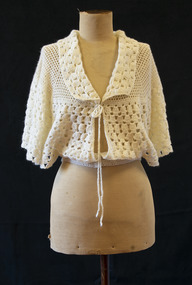 Brighton Historical Society
Bed jacket, circa 1955
... Carmela recalled her father cheerfully walking the streets, greeting people by name. He knew everybody. He loved being in Australia and enjoyed life to the last, insisting on having bread and wine on the table at every meal....Carmela recalled her father cheerfully walking the streets, greeting people by name. He knew everybody. He loved being in Australia and enjoyed life to the last, insisting on having bread and wine on the table at every meal. bed jacket migration 1950s carmela auditore carmela materia giuseppa auditore Cream crocheted wool bed jacket. ...This bed jacket was crocheted for Carmela Materia (1931-2018) by her mother, Giuseppa Auditore, around the time they emigrated from Italy to Melbourne. Both women were longtime Brighton locals, residing in the area from the 1950s until their deaths. Carmela Auditore was the first woman from her home village of Scaletta, Italy to emigrate to Australia. Setting sail alone in 1950 at the age of 19, she joined her brother John and uncle Frank in McCallum St, Brighton. Frank had arrived some years earlier and had spent the duration of the First World War in an internment camp. John worked at the Brighton Case Company, a box manufacturer on Nepean Highway, and paid for her passage. Carmela found a job sewing children's clothing at Drummonds, a small factory in Church St. Working eight hours a day, five days per week, netted her a weekly wage of three pounds. To earn a little extra, she washed dishes at a St Kilda Road restaurant for ten shillings a shift. Her parents, Salvatore and Giuseppa Auditore, joined her in Brighton in 1952. They rented a house behind an antique shop in Bay Street. Salvatore had been a fisherman in Scaletta, but quickly adapted to the job he found helping around the Garage at Brighton Motors in Male Street. On 14 February 1953, Carmela married her sweetheart, Salvatore Materia, at St James Catholic Church in Gardenvale. Salvatore had been living with his aunt in Well Street and worked on the wharves. Both Carmela and Salvatore were hard workers. They owned a fruit shop in Church Street where Woolworths now stands, and years later Carmela recalled the familiar 6am tap on her window each morning when her husband returned from the market. On dark winter mornings, she felt as if her hands would freeze as she helped Salvatore unload cold cabbages and cauliflowers from his truck. They later owned a shop in Ludstone Street in Hampton. After Salvatore died suddenly at the age of 48, Carmela returned to sewing, working at the Willow Fashions knitting mill in Gardenvale. She later went into partnership with her sister and brother-in-law, this time in the delicatessen business. Her parents, Giuseppa and Salvatore, spent the rest of their days with Brighton. Carmela recalled her father cheerfully walking the streets, greeting people by name. He knew everybody. He loved being in Australia and enjoyed life to the last, insisting on having bread and wine on the table at every meal.Cream crocheted wool bed jacket. Loose around bust with wide sleeves and open sides. Fastens at collar with thin braided ties, and at waist with two pearlescent plastic buttons.bed jacket, migration, 1950s, carmela auditore, carmela materia, giuseppa auditore -
 Department of Health and Human Services
Photograph, Berry Street Kindergarten
... In 1977 Berry Street to established a family group home in Richmond to house children affected by the closure of St Cuthbert's Children's Home in Colac. Berry Street changed its name to Berry Street Child and Family Care in 1977. ...In 1977 Berry Street to established a family group home in Richmond to house children affected by the closure of St Cuthbert's Children's Home in Colac. Berry Street changed its name to Berry Street Child and Family Care in 1977. ...In 1877 the Victorian Infant Asylum was founded in Kew. In 1881, the asylum relocated to Berry Street in East Melbourne. By 1908, it was called the Foundling Hospital and Infants Home. It was non-denominational and controlled by a committee of management. By 1956, Berry Street consisted of a Mothercraft Training Centre and two main residential units: Berry Street for infants aged zero to 18 months, and Vale Street for toddlers aged zero to two years old. In August 1956, Berry Street was declared an approved category 2 Children's Home. In 1960, Vale Street was converted to an adult nursing home. In 1964, the name was changed to Berry Street Babies Home and Hospital. Berry Street was also an approved adoption agency. By 1968, Berry Street comprised the Training School for Mothercraft Nurses, the adoption agency, an infant life-protection house, a long-stay home for children to three years of age (the toddlers’ wing) and a small house for unmarried mothers. The home's infant life-protection work was seen as a critical agency function, particularly where family illness was putting pressure on mothers and Berry Street was able to provide respite and support. By the late 1960s, 30–40 adoptions annually were being arranged from Berry Street. By 1974 the home's orientation had shifted. Four family group homes had been established (two in Burwood, one in Ashburton and one in St Kilda), the mothercraft training function had been phased out, the toddlers wing converted to day care, and the main building (containing the nursery, administration, kitchen, dining room and single mothers accommodation) was demolished in favour of four home units, which housed 24 children, supervised by cottage parents. Berry Street provided short term, emergency and residential care for 'protection of infant' cases and state wards. Two flats were also established for short-term family accommodation. The nurses’ home was converted to house the home’s administration function and a social work service. The social work service coordinated family aid and family counselling services, and a neighbourhood house. In 1975 Berry Street also provided short-term care for 42 Vietnamese children brought to Australia in the official government-sponsored airlift. In 1976 Berry Street made application to change its category 2 Children's Home classification to category 1, as it was now catering for a wider range of children. It had ceased to be a babies’ home and hospital, and had started providing child and family care, including residential care. In 1977 Berry Street to established a family group home in Richmond to house children affected by the closure of St Cuthbert's Children's Home in Colac. Berry Street changed its name to Berry Street Child and Family Care in 1977. In 1978, the range of services provided by Berry Street Child and Family Care consisted of a social work counselling service, a financial aide, a family aide program using volunteers, two temporary accommodation units each housing eight children, an information and referral service, a neighbourhood house in Richmond, a day care centre for 36 children, and four family group homes. In 1980–81 the family group homes in Burwood were sold and the resources moved to the Richmond area. In 1994, Sutherland Youth and Family Services Inc. amalgamated into Berry Street Inc. During the 1990s, Berry Street combined with the Sutherland Community Resource Centre in Watsonia in Melbourne’s northern region. The agency operates today as Berry Street Victoria and has service centres across metropolitan and country Victoria. https://www.findingrecords.dhhs.vic.gov.au/CollectionResultsPage/BerryStreet -
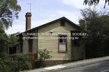 Eltham District Historical Society Inc
Photograph - Digital Photograph, Alan King, Southernwood, cnr Bolton and Brougham Street, Eltham, 30 January 2008
... A small park at the corner of Bible and Arthur Streets, Eltham is named in Walter Withers’ honour....A small park at the corner of Bible and Arthur Streets, Eltham is named in Walter Withers’ honour. This collection of almost 130 photos about places and people within the Shire of Nillumbik, an urban and rural municipality in Melbourne's north, contributes to an understanding of the history of the Shire. ...Walter Withers once lived at the corner of Bolton and Brougham Streets, Eltham. Covered under Heritage Overlay, Nillumbik Planning Scheme. Published: Nillumbik Now and Then / Marguerite Marshall 2008; photographs Alan King with Marguerite Marshall.; p105 Walter Withers, one of Australia’s most famous artists, once lived in Southernwood, the weatherboard house at the corner of Bolton and Brougham Streets, Eltham. Withers, one of the first prominent artists to live in Eltham, was known for his lyrical paintings of the Australian bush and is associated with the Heidelberg School of artists. Withers was born in 1854 at Handsworth, Warwickshire, England, the grandson of an artist. He studied art at the Royal Academy of Arts, London. But in 1882 his father, opposing an artistic career for Withers, ordered him to go to Australia. However, after working as a jackaroo on several country properties for 18 months, Withers resumed painting in Melbourne, where he enrolled in evening art classes at the Melbourne National Gallery school of painting under G F Folingsby. Employed as a draughtsman by William Inglis & Co, then by Ferguson & Mitchell, lithographic printers, Withers produced portraits in black-and-white for several periodicals. His work was exhibited in the Old Academy, Melbourne. At this time he met and became life-long friends with artists Frederick McCubbin, Tom Roberts and Louis Abrahams. In 1887 Withers went to England and married Fanny Finn. They lived in Paris for awhile, where Withers studied at the Academie Julian. After his return to Melbourne in 1889, Withers lived at the artist camp at Eaglemont, then moved close to the Charterisville mansion, where he established a studio and sub-let cottages to other artists. Around 1892 Withers opened a Collins Street studio, had his first exhibition, and started giving painting classes. One of his pupils was Norman Lindsay, also to become a prominent artist. Withers had long been attracted to Eltham, but had to wait until 1903 to live there, after the railway line was extended to Eltham in 1902. He could then commute to the painting classes he gave in Melbourne. Withers lived on the two and a half acres (1.0ha) Bolton Street property with his wife and five children. They were joined for a short time by prominent painter Sir Hans Heyson who took lessons from Withers. Withers added a studio to the Queen Anne/Edwardian style seven-bedroom home, which had been built in 1891. Each bedroom included a fireplace and most rooms had 12 foot high (3.6m) ceilings. The house retains several fine leadlight windows. Withers painted his largest canvas The Return from the Harvest in 1905, at his Eltham studio. He is represented in national, state and regional galleries, and in many private collections in Australia and abroad. In 1904-05 Withers was president of the Victorian Artists’ Society. Withers at times stayed during the week at his studio in Oxford Chambers, Melbourne, and on weekends and holidays with his family at Eltham. Withers lived in Eltham until his death in 1914, aged 60 years. He had been plagued by rheumatism and in later life by heart and lung disease. It is said he died of a stroke peacefully in a rocking chair in front of the lounge-room fire. He is buried at St Helena in the St Katherine’s Anglican Church cemetery. In 1983, the auction of the house sparked fears that it would be pulled down, or substantially altered. Fortunately the new owners decided to retain the house. Some security was given to the house’s future when it was later included in the Heritage Overlay to the Nillumbik Planning Scheme. The property is also important because it is one of only a few left in the district, which were once owned by noted artists. These include three in Warrandyte: one formerly owned by Penleigh Boyd, another by Frank Crozier, and the other by Danila Vassilieff; and two in Eltham: Percy Leason’s in Lavender Park Road and Justus Jörgensen’s Montsalvat. A small park at the corner of Bible and Arthur Streets, Eltham is named in Walter Withers’ honour.This collection of almost 130 photos about places and people within the Shire of Nillumbik, an urban and rural municipality in Melbourne's north, contributes to an understanding of the history of the Shire. Published in 2008 immediately prior to the Black Saturday bushfires of February 7, 2009, it documents sites that were impacted, and in some cases destroyed by the fires. It includes photographs taken especially for the publication, creating a unique time capsule representing the Shire in the early 21st century. It remains the most recent comprehenesive publication devoted to the Shire's history connecting local residents to the past. nillumbik now and then (marshall-king) collection, bolton steet, brougham steet, eltham, southernwood, walter withers house -
 Eltham District Historical Society Inc
Document, Russell Yeoman, Tour of Historic Buildings and Locations, 1978
... Early records show that Falkiner was the subject of a number of complaints from his neighbours but he has nevertheless been considered a prominent enough citizen to have a street named for him. This house was the home of Evelyn (Ely) Falkiner a member of Frederick's family. 32. ...Early records show that Falkiner was the subject of a number of complaints from his neighbours but he has nevertheless been considered a prominent enough citizen to have a street named for him. This house was the home of Evelyn (Ely) Falkiner a member of Frederick's family. 32. ...Self guided heritage tour information produced by the Shire of Eltham Historical Society for 1978 Eltham Community Festival of 36 locations each numbered on accompanying map. Locations and detail provided current to 1978: 1. ELTHAM SHOPPING CENTRE Whilst very little remains in the centre of historical importance, this area has interest as the "village" which developed over many years following the opening of the railway from Melbourne in 1902. Previously the shopping centre had been spread out over a long length of Main Road to the south. Shops have been continuously demolished or remodelled and the majority of buildings date from the 1950's or later. The recently erected Post Office replaced the "old" Post Office opened on the same site only in 1958. 2. WOOLWORTHS ELTHAM VILLAGE Part of the site of this modern shopping development was occupied by the former Eltham Shire Offices and Hall. The hall was paid for by public subscription whilst the Council raised a loan for the offices. The combined building was opened in 1941. It served as office and Council meeting place until 1965 and as the hall until its demolition in 1970. 3. ELTHAM WAR MEMORIAL The complex of buildings adjoining the present Shire Offices were financed by public subscription as a Memorial following World War II. Their construction and for many years their operation was organised by the now disbanded Eltham War Memorial Committee. The original buildings were the; Infant Welfare Centre, Children’s Library (now War Memorial Hall and Dental Clinic) and Kindergarten. In later years the Elderly Citizens Club was built at the rear. 4. ELTHAM SHIRE OFFICES These offices were opened in 1965 and extended in 1971 to provide additional office accommodation and the Eltham Library. They represent the last of a long line of offices and meeting places of the Eltham Shire Council and its predecessor the Eltham District Road Board. The building occupies the former site of Shillinglaw Cottage. The three tall cypress trees which stood in front of the Cottage have been retained as a feature of the office surrounds. 5. OUR LADY'S CHURCH AND SCHOOL The Catholic Church and School complex opposite the Shires Offices shows a number of stages in the development of Eltham township. The recently constructed church adjoins its predecessor (now the parish centre). Many years ago the Catholic Church was located opposite Wingrove Park and the present central site follows the northerly drift of the township. 6. SHILLINGLAW COTTAGE The Cottage was built in 1859 by George Stebbing, a local builder who was responsible for a number of other prominent buildings in the area. Its removal from the site of the Shire Offices and re-erection on the present site was financed by public subscription. It is built of handmade bricks laid in Flemish Bond with an unusual design featuring burnt "leader" bricks over the whole facade. The Cottage is occupied by Eltham Fleececrafts and will be open during the Festival and at other times during weekends. It is classified by the National Trust. 7. RAILWAY BRIDGE The timber trestle bridge over the Diamond Creek was built in 1901. Whilst all of its timbers have been replaced at various times over the years the only change to its character has been the addition of pylons and wiring for electric trains in 1923. It is one of very few similar bridges remaining in the metropolitan area. In 1976 a proposal to replace the bridge with an earth embankment and large culvert pipes was abandoned following community protests. The bridge, however, remains under threat because of the necessity for future deuplication of the railway line. 8. ELTHAM CENTPAL PARK The area between the railway and the creek has for many years been used as a park which included Eltham' s main football oval. The access road, Panther Place is named after Eltham's team playing in the Diamond Valley League. In recent years a large area extending to Bridge Street and locally known as the Town Park has been landscaped and added to the area. The excellent blending of the park with the natural landscape of the creek valley has earned a National Trust Landscape Classification. 9. OLD BAKERY On the southern corner of York Street and Main Road is an old house with a shop front which was for many years the local baker's shop. The brick bakery at the rear is of somewhat later vintage than the house. 10. BRIDGE STREET CUTTING Before reconstruction of Main Road this intersection had deep cutting embankments on all four corners, forming a distinctive feature of the entrance to Eltham. Roadworks and private development have levelled the land on the low side of the road. A memorial to the Eltham soldiers of World War I which was located at the north-western corner is now situated at the Eltham R.S.L. 11. HILLTOP MILK BAR For many years this was the site of the Eltham Post Office under the control of the Hunniford family and later their descendants the Burgoynes. It was transferred to this site in 1855, although at that time the building apparently fronted Bridge Str e et. The site contained Eltham's first telephone exchange. The post office was relocated in 1954 but the shop was operated until recently by the Burgoyne family who still own the surrounding land. 12. UNITING CHURCH and former C.B.A. BANK The former Methodist Church was built in 1880 by George Stebbing. The Sunday School extension was built in 1929 and there have been more recent extensions. The adjoining opportunity shop was built as a bank in 1874 and purchased by the Methodist Church in 1954. 13. R.S.L. HALL, TELEPHONE EXCHANGE These relatively recent buildings occupy the site of a row of shops forming part of the early ribbon of business development along Main Road. In front of the R.S.L. building is the World War I Memorial relocated from the corner of Bridge Street and Main Road. 14. ELTHAM COMMUNITY CENTRE Australia's first mudbrick "community building" was opened in April this year. Part of the site of the building was purchased in 1856 by Henry Dendy (of Brighton fame). At the rear of the land near the creek was a steam flour mill whilst Dendy's house was at the Main Road frontage of the land. His purchase totalled about 2 Ha (5 acres) and included land on the opposite side of Maria Street (Main Road). Dendy became a prominent member of the Eltham community and served one term as President of the Eltham District Road Board. In 1867 Dendy sold his land and business to William Ford of Malmsbury and shifted to Walhalla. The avenue of trees leading past the Community Centre to the creek may well have bordered the track to the mill. 15. ELTHAM HOTEL The original part of this hotel was built in 1927 following the burning of the former Watson's Eltham Hotel on the same site. The car park on the opposite side of Main Road was also the site of a hotel variously known over the years as; the Fountain of Friendship, the Fountain and the Evelyn Arms. As the Fountain of Friendship it was the first meeting place of the Eltham District Road Board in 1856. 16. ST. MARGARET'S CHURCH, PITT STREET In 1860 Henry Dendy was appointed Chairman of a committee to establish a church of England in Eltham. He donated part of his land in Pitt Street and in 1861 the church was opened. It was built by George Stebbing and remains in a well preserved state today. Th adjoining old vicarage is now named Dendy Hou se. A new mudbrick church hall is under construction on the site. The church and Dendy House are now listed on the Register of Historic Buildings. 17. NO. 86 PITT STREET Cottage built by George Stebbing and believed to be his home for some years in the 1850s. 18. LIVING AND LEARNING CENTRE The house was built in the 1850s with the kitchen at the front being added about 40 years later. By the creek below the house a number of early Eltham industries were located. These included a tannery and a brewery. 19. ELTHAM COURT HOUSE A Court of Petty Sessions was established in Eltham in 1858 and the present building dates from 1860. It is the oldest public building remaining in Eltham. In its early days the building was used as the meeting place and office of the Eltham District Road Board and as an overflow classroom for the local school. The Court House has been classified by the National Trust. The citation states that it is an example of the simple form of early brick Court House with gabled roof and porch. 20. LANDS DEPARTMENT OFFICE This building is the former police station and is probably of about the same age as the Court House. The lockup at the rear has been demolished but the old stables remain as garages. A licence was first granted for a police station at Eltham in 1856. 21. JARROLD COTTAGE The old Cottage opposite Dalton Street was formerly owned by the Jarrold family. Early records indicate that this was the building leased from the Jarrolds as a temporary police station prior to construction of the building on the corner of Brougham Street. The small building on the corner of the property was used as a boot repairer's shop. The elevated studio at the rear is a more recent construction by the present owners. 22. STATE SCHOOL RESIDENCE Erected in 1891 23. WINGROVE COTTAGE This building fills an important place in the history of Eltham and is now used as a medical clinic. It was built in 1858 for Charles S. Wingrove who was Secretary to the Eltham District Road Board and Shire Council from 1858 to 1904. During part of this period he was also Shire Engineer and was Secretary to the Heidelberg Road Board. The house was used as the office of the Board and Council for many years. Wingrove is buried in the cemetery at St. Helena. 24. WINGROVE PARK The parkland opposite Wingrove Cottage has been named after Charles Wingrove. The old Manna Gums are an outstanding feature of the park. 25. ELTHAM FRI.MARY SCHOOL NO. 209 The school first opened in the slab building in 1855 and operated from the present site since 1857. The oldest part of the present school is the stone building erected in 1876. The first school teacher, David Clark remained at the school until 1888. This school is the government township and has always been known as the Eltham School. An earlier school (no.371) known as Little Eltham School operated in Swan Street from 1853 to 1872. 26. "SHOESTRING" This house was built for school teacher David Clark. It has been extensively extended in recent years but the extensions do not detract from the character of the older part of the building. 27. ELTHAM CEMETERY The cemetery contains the graves of many of the district's pioneers . 28. MONTSALVAT This unique complex of buildings was commenced in 1935 by the late Justus Jorgensen and its development has extended over many years. Montsalvat has exerted a significant impact on Eltham The earth and stone construction of many of the buildings has influenced local architecture to a great extent and it has served as a "nerve centre" of the local artistic community. Montsalvat is open to the public for a small charge. 29. MAIN ROAD BRIDGE This location has been the main crossing of Diamond Creek since the earliest days of settlement. The present concrete bridge was erected in 1925 .and was preceded by a number of timber bridges. 30. ELTHAM LOWER PARK This park, being an unusually large flat area for Eltham, was originally the local racecourse. Horse races were held here from 1855 and the area was gazetted as a reserve for a racecourse and recreation reserve in 1857. The park is well known as a venue for school "bird days" and more recently as the site of the Diamond Valley Railway. This miniature railway features scale models of modern and old locomotives and rolling stock and has operated on this site since 1961 . Before that the railway operated at Chelsworth Park, Ivanhoe. 31. FALKINER HOUSE Frederick Falkiner was one of the earliest settlers in the Eltham township area and occupied a substantial leasehold prior to the first land sales. Early records show that Falkiner was the subject of a number of complaints from his neighbours but he has nevertheless been considered a prominent enough citizen to have a street named for him. This house was the home of Evelyn (Ely) Falkiner a member of Frederick's family. 32. WEST HOUSE Behind the large house on the hill is an early house built by the West family. This was relocated from a site near the front of the land by the present owner Mr. Fabbro. 33. FALKINER HOUSE This very old house is believed to have been the home of Frederick and may have been Eltham's first post office. Falkiner was the first post master for a short period. in 1854/55. 34. WITHERS HOUSE This house was the home of famous artist Walter Withers who shifted here from Heidelberg in 1903. 35. ELTHAM HIGH SCHOOL This school celebrated its jubilee this year, having commenced as the Eltham Higher Elementary School 50 years ago. 36. DIAMOND CREEK FOOTWAY If returning from the High School to the town centre the footpath by the bank of the Diamond Creek provides a pleasant route to finish your walk. The creek is a major tributary of the Yarra River. Together with its own major tributaries Arthurs Creek and Running Creek it commences on the southern slopes of the Dividing Range at Kinglake. It gives the name Diamond Valley to an area extending well beyond its actual drainage catchment.Recognition of the significance of various landmarks to the history of the Eltham community as of 1978‘shoestring’, 1978, bridge street cutting, burgoyne store, c.b.a. bank, diamond creek trail, eltham cemetery, eltham central park, eltham community centre, eltham community festival, eltham court house, eltham festival, eltham high school, eltham hotel, eltham lower park, eltham primary school, eltham railway trestle bridge, eltham shire offices, eltham shopping centre, eltham state school no. 209, eltham village, eltham war memorial, falkiner house, heritage trail, hilltop milk bar, jarrold cottage, lands department office, living, living and learning centre, main road bridge, montsalvat, old bakery, our eltham artistic recollections, our lady help of christian’s church, our lady help of christian’s primary school, pitt street, post office, r.s.l. hall, shillinglaw cottage, st margaret’s church, state school residence, stebbing cottage, telephone exchange, uniting church, west house, wingrove cottage, wingrove park, withers house, woolworths -
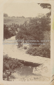 Eltham District Historical Society Inc
Postcard - Photograph postcard, Old Bridge, Kaylock's Crossing, Brougham Street, Eltham, c.1912
... It was one of several east-west streets shown on the subdivision plan as crossing the Diamond Creek. The western part was named Wellington Street on the subdivision plan but was later changed to conform with the name of the eastern part as acknowledgement of the continuity of the street. ...It was one of several east-west streets shown on the subdivision plan as crossing the Diamond Creek. The western part was named Wellington Street on the subdivision plan but was later changed to conform with the name of the eastern part as acknowledgement of the continuity of the street. ...Date estimated to be circa 1912 based on the style of printing on the reverse of the card - Kodak Austral paper for real photo postcards, the paper was manufactured c.1908-1914 (See also POSTCARDS ON KODAK PAPER - IS IT POSSIBLE TO "DATE" THEM? http://tps.org.au/bb/viewtopic.php?t=115) Brougham Street was created in Josiah Holloway's 1851 subdivision of Little Eltham. It was one of several east-west streets shown on the subdivision plan as crossing the Diamond Creek. The western part was named Wellington Street on the subdivision plan but was later changed to conform with the name of the eastern part as acknowledgement of the continuity of the street. It is not known when the first bridge was constructed in Brougham Street however it was certainly mentioned at Council’s meeting of 2 June 1884 as being in a dangerous state of repair. This photo (c.1895) of an old bridge shows a very low-level simple log girder bridge crossing the creek at a right angle and so the approaches involved bends in the road alignment. This bridge was generally known as Kaylocks Bridge or Kaylock’s Crossing after the owner of the adjoining land. It was most likely built from around the mid-1850s, or a crossing of some fashion established as Richard George Kaylock, butcher of Little Eltham and his wife Emily Ann settled there in 1854. His property was in Wellington Street (now Brougham Street) and apparently extended across the Diamond Creek. The land on the western side of the creek was farmed, the house being on the eastern side. Kaylock's Bridge formed part of the original coach road to Eltham and in 1922 was described as an "old rustic bridge". Its low level and insubstantial construction made it susceptible to flood damage, necessitating frequent closures until repairs could be carried out. In September 1922, Council called for tenders for a new timber bridge to be constructed at Kaylock’s crossing. An engineering assessment carried out for the Council by Macleod Consulting at the time of the replacement suggested that the construction details indicate that it was in the 1900s, however this dating could possibly have been the result of numerous repairs undertaken over the years to flood damage. The tender was awarded to Mr Weller of Kangaroo Ground who commenced work in February 1923 on a higher-level timber trestle bridge. Work was slowed due to illness of the contractor and the accidental death of a man in March 1923 following the collapse of the bank after he had jumped into a hole that had just been blasted. The bridge was completed around July 1923 at which point the old structure was pulled up, marking what was described in the ‘Advertiser’ newspaper as the passing of an old and well-loved landmark in the district. In April 1924 the approach to Kaylocks bridge was washed away during the heavy flooding that destroyed the Main Road bridge. The western side was repaired, and an extra span was added to the eastern side using timber from the destroyed Main Road bridge. The bridge was again severely damaged four months later in August 1924 When a lack of finances delayed repairs to the Bridge Street bridge in 1931 (also referred to as Obelisk Bridge at the time), traffic had to detour via Brougham Street for some time. Local residents feared that the Bridge Street bridge might never reopen. Kaylocks Bridge was constantly subject to damage by floods. In the 1934 flood it was submerged by two feet of water. In more recent times the bridge was again severely damaged by flooding and repairs made. A new bridge and adjoining footbridge were constructed in 2009.Digital file only Postcards scanned from the collection of Michael Aitken on loan to EDHS, 2 Sep. 2022michael aitken collection, eltham, postcards, bridge, brougham street, diamond creek (creek), kaylocks bridge, wellington street -
 Eltham District Historical Society Inc
Photograph, Peter Pidgeon, Graves of Mary Josephine Swallow, John Swallow (unmarked) and Patricia Catherine Hill, Eltham Cemetery, Victoria, 5 April 2021
... shall remain a mystery but within six months of this horrific event, the street had been re-named to Lavender Park Road after the original property near the end of the road, Lavender Park. ... shall remain a mystery but within six months of this horrific event, the street had been re-named to Lavender Park Road after the original property near the end of the road, Lavender Park. ...On the 29th of May 1954, a local Eltham carpenter by the name of John Swallow, committed a double murder at his home on New Street. This happened on the same day as the federal election of that year. John 48, his wife Mary 47, and stepdaughter Patricia 25, all went to the Eltham Courthouse on Main Road to cast their vote in the election that Saturday. After voting they returned home to their New Street house around midday. Patricia would later recall to ambulance officers, that she was feeling unwell, and so went to lay down when she heard an argument erupt over voting between her mother Mary and stepfather John. A concerned neighbour heard loud thudding noises and yelling coming from John and Mary’s house, he went to investigate. When he arrived at the house he was met by John at the front door. He would later describe John as “having a frantic look upon his face, and manic eyes”. John must have been a sight, bleeding and clutching a cut throat razor by his side. He then announced to the neighbour, “they voted commie!” before turning and going back inside. The distressed neighbour immediately raced home to call the Police. When the police arrived, they found Mary dead on the kitchen floor from catastrophic head injuries; her daughter, Patricia, clinging to life, slumped on her bed. Both women had been attacked by the same weapon, a large hammer, or sledge hammer as reported by the newspapers. John was also discovered in the house, bleeding from self-inflicted wounds from the razor, and had attempted to ingest caustic soda. Patricia was taken to St Vincent’s hospital, but died the following day, the 30th of May. John was also taken to St Vincent’s, where he remained under constant police guard for several months while he recovered from his injuries, at least the physical. He was eventually well enough to be taken to the City Watch House and then Pentridge Prison before his trial in October of the same year. When it came time for John to face the courts, the Judge called a mistrial, the Crown would not prosecute on the grounds of insanity. John was led away from the dock of The Magistrates Court and taken directly to Willsmere, the Kew Mental Asylum. On the 9th of August 1962, John Mervyn Swallow died of heart failure, he was 57. He had been a resident of Kew for four years. John’s body was returned to Eltham Cemetery and buried in the same grave as Mary. There is no mention of his name on the head stone. Patricia’s grave is next to Mary and John. A sad irony has an angel upon her grave, “its head missing”, possibly vandals or just an accident of time and events. What became of the home where all of this took place on New Street shall remain a mystery but within six months of this horrific event, the street had been re-named to Lavender Park Road after the original property near the end of the road, Lavender Park. In Memory Of Mary Josephine Swallow Died 29th May 1954 aged 47 Also Patricia Cathryn Hill Dearly beloved wife of Kel Called home 30th May 1954 Aged 25 yearsBorn Digitaleltham cemetery, gravestones, mary josephine swallow, patricia catherine hill, john swallow -
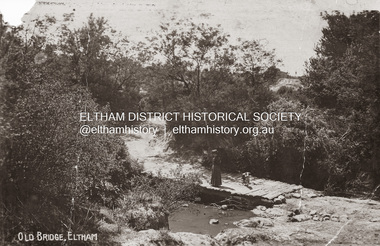 Eltham District Historical Society Inc
Photograph, Old Bridge, Kaylock's Crossing, Brougham Street, Eltham, c.1895
... It was one of several east-west streets shown on the subdivision plan as crossing the Diamond Creek. The western part was named Wellington Street on the subdivision plan but was later changed to conform with the name of the eastern part as acknowledgement of the continuity of the street. ...It was one of several east-west streets shown on the subdivision plan as crossing the Diamond Creek. The western part was named Wellington Street on the subdivision plan but was later changed to conform with the name of the eastern part as acknowledgement of the continuity of the street. ...Brougham Street was created in Josiah Holloway's 1851 subdivision of Little Eltham. It was one of several east-west streets shown on the subdivision plan as crossing the Diamond Creek. The western part was named Wellington Street on the subdivision plan but was later changed to conform with the name of the eastern part as acknowledgement of the continuity of the street. It is not known when the first bridge was constructed in Brougham Street however it was certainly mentioned at Council’s meeting of 2 June 1884 as being in a dangerous state of repair. This photo (c.1895) of an old bridge shows a very low-level simple log girder bridge crossing the creek at a right angle and so the approaches involved bends in the road alignment. This bridge was generally known as Kaylocks Bridge or Kaylock’s Crossing after the owner of the adjoining land. It was most likely built from around the mid-1850s, or a crossing of some fashion established as Richard George Kaylock, butcher of Little Eltham and his wife Emily Ann settled there in 1854. His property was in Wellington Street (now Brougham Street) and apparently extended across the Diamond Creek. The land on the western side of the creek was farmed, the house being on the eastern side. Kaylock's Bridge formed part of the original coach road to Eltham and in 1922 was described as an "old rustic bridge". Its low level and insubstantial construction made it susceptible to flood damage, necessitating frequent closures until repairs could be carried out. In September 1922, Council called for tenders for a new timber bridge to be constructed at Kaylock’s crossing. An engineering assessment carried out for the Council by Macleod Consulting at the time of the replacement suggested that the construction details indicate that it was in the 1900s, however this dating could possibly have been the result of numerous repairs undertaken over the years to flood damage. The tender was awarded to Mr Weller of Kangaroo Ground who commenced work in February 1923 on a higher-level timber trestle bridge. Work was slowed due to illness of the contractor and the accidental death of a man in March 1923 following the collapse of the bank after he had jumped into a hole that had just been blasted. The bridge was completed around July 1923 at which point the old structure was pulled up, marking what was described in the ‘Advertiser’ newspaper as the passing of an old and well-loved landmark in the district. In April 1924 the approach to Kaylocks bridge was washed away during the heavy flooding that destroyed the Main Road bridge. The western side was repaired, and an extra span was added to the eastern side using timber from the destroyed Main Road bridge. The bridge was again severely damaged four months later in August 1924 When a lack of finances delayed repairs to the Bridge Street bridge in 1931 (also referred to as Obelisk Bridge at the time), traffic had to detour via Brougham Street for some time. Local residents feared that the Bridge Street bridge might never reopen. Kaylocks Bridge was constantly subject to damage by floods. In the 1934 flood it was submerged by two feet of water. In more recent times the bridge was again severely damaged by flooding and repairs made. A new bridge and adjoining footbridge were constructed in 2009. Part of a slide show presentation "Bridges & Waterways of the Shire" by Russell Yeoman to the 13 September 1989 Society meeting. The presentation included slides of historic photos from the Shire of Eltham Pioneers collections as well as several recent views.Photo of earliest known crossing of the Diamond Creek at brougham StreetPostcard photo printbrougham street, eltham, wellington street, kaylocks bridge, bridge, diamond creek (creek) -
 National Wool Museum
Textile - Waistcoat, R. Collins Hocking, c.1910
... Her family lived at “Turley,” Malop Street, Geelong, named after the hamlet of Turleigh in West Wiltshire, England. ...Her family lived at “Turley,” Malop Street, Geelong, named after the hamlet of Turleigh in West Wiltshire, England. ...The Waistcoat’s Owners The first owner of the waistcoat was Alfred (Alf) Gilbert White, 1868 Stretton Park, Connewarre – 1946, Mt Duneed. He was the fourth child of Andrew White, 1828-1900, and Jane Roberts, 1827-1871. His father Andrew White was born at Stretton-on-Dunsmore, Warwickshire, England, the sixth child of William White and Sarah Elkington. Andrew had come to Victoria on the James L. Bogart in 1852 with his first wife, Emily Walker. From 1854, records show he was the owner of livery stables in central Geelong before he moved into land ownership. In 1862, Andrew became a landowner with 1,400 acres in Connewarre, the Salt Water Run, then re-named Stretton Park by Andrew. Thereafter he is usually noted as a Farmer or Sheep Farmer. Emily died in 1861 and Andrew remarried Jane Roberts in 1863. Jane was the daughter of Jane (Jenefer) Pearce and William Roberts in Crowan, Cornwell, England and it is thought arrived in Victoria on the British Trident in 1855. In 1878 Andrew moved to the newly purchased “Hillside” at Mt Duneed with his family including Alfred. By 1880 Andrew held 11,095 acres in South Barwon and Barrabool. As well as being a landowner, he had other business interests including Auctioneers, Stock and Station Agents Learmonth White from 1886. However farming at Hillside, particularly wool production, was an important part of his life. For example, in 1893 10,350 sheep were shorn although the highest number of bales of wool produced was in 1892 with 174 bales under AW’s wool mark and 8 under that of Stretton Park. This was the result of shearing 9,234 sheep. There were usually six or seven shearers, shearing over a two to three week period, beginning in early or mid October. Some of the shearers bore names familiar in the district such as Gogoll, Duffield, and Baensch. Andrew White held a number of local positions including: •1863-1874 Connewarre Road Board, Chairman 1871-73 •1875-1900 South Barwon Shire Council. When the Board amalgamated with South Barwon to form the Shire of South Barwon, he was an inaugural representative of Connewarre. He was a council member for 44 years and president for the following terms: 1878-1879; 1885-1887; 1889; 1894; 1895-1896; and 1898-1899. •1878-1886, Barrabool Shire Council, President 1882 •In 1885 he was appointed a Justice of the Peace in the Southern Bailiwick •Committee member of the Geelong Racing Club, 1890-96 •In 1892 he was appointed returning officer for the South-Western Province and the electoral district of Barwon •Foundation President of Torquay Racing Club, 1893 •Mount Duneed Cemetery Trustee, 1893 Alfred Gilbert White went to Connewarre School and then to Mt Duneed School after the family moved to Mt Duneed. He then went to Geelong Grammar School as a boarder from 31 July 1883. After leaving school, in 1886, he worked as a bookkeeper for the family business Learmonth-White stock and station agents and lived at home at Hillside. He and Bessie Orchard Mathews were married in 1894. Bessie was born in Geelong in 1869, the sixth child of William Matthews and Amelia Orchard. Her family lived at “Turley,” Malop Street, Geelong, named after the hamlet of Turleigh in West Wiltshire, England. Bessie’s father, William Mathews, a butcher from Winsley, Wiltshire, arrived on the Queen of the East in Sydney in 1854 and established a successful butcher’s business with his brother James in Geelong. Her mother, Amelia Orchard, also from Winsley, arrived on the Thames in Melbourne in 1857. Alfred, Bessie and their family lived at Stretton Park, Connewarre, leasing it from Andrew. They had six children including their fourth child Douglas Alfred White, the second owner of the waistcoat. His father Andrew supported Alfred’s sheep farming at Stretton Park. In 1896 “.... eight splendid 2-tooth Lincoln rams in the wool were purchased by Mr Andrew White for his son, Mr Alfred G. White….intended for Mr White’s sheep run at Connewarre.“ Alfred White bought ‘Hillside’, 640 acres, after his father’s death and moved there with his family from Stretton Park in Connewarre. (Stretton Park was bought by his half sister Emily and her family and renamed “Morangarell”.) A family partnership was formed to run the wider station. It was then Alfred who managed the new partnership, called Stretton Park. Alfred meticulously kept the financial records of the station, as might be expected from a former bookkeeper. The detail kept is exemplified in the annual shearing records, including the names of the paddocks, the number of lambs and ewes and the shearers’ tallies. In the spring of 1900, after Andrew White had died, shearing began on 7 October and was finished on 6 November. On some days well over 500 sheep were shorn. The highest tally was 616 on 11 October. That year the overall total of sheep shorn was 9,101. Alfred was an active community member including: •South Barwon Council member (46 years), president: 1903-04; 1906-07; 1921-22; and 1931-33 •Geelong Grammar School Council member, 1908-1946 (over 37 years) •Active member of St. Wilfred’s Church of England, Mt Duneed •Director of Dennys Lascelles, 1932-1946 •Mt Duneed Cemetery Trustee, 1900 •Honorary member of the Mt Duneed Rifle Club, 1900 •Mt Duneed Mutual Improvement Association •Mt Duneed Recreation Reserve Trustee •Torquay Improvement Association Trustee •Barwon Returning Officer Douglas Alfred White, 1900 Stretton Park, Connewarre-1976, Geelong. Initially Douglas and his sisters were taught at home by a governess. Then, like his father, Douglas attended Geelong Grammar. After finishing school, he studied Engineering at Melbourne University where he met Violet Fullerton, 1900-1992, who was studying Medicine. They married in 1926 and had two children including Douglas Robert Stretton (DRS) White Melbourne, 1928–Geelong, 1989, the final owner of the waistcoat. After a successful career as an engineer with the Department of Main Roads, NSW, and serving as a Major in the Royal Australian Engineers in NT, New Guinea and Borneo during the Second World War, Douglas purchased part of Stretton Park when it was sold in 1952. He farmed “South Beach Farm” until his death in 1975. (This area now includes The Sands and Stretton Estate subdivisions.) His son DRS White also attended Geelong Grammar before studying at Dookie Agricultural College. In 1955 DRS purchased land from Peter Fisher, John Fisher and Frank Walter, naming the property “Lambidgee”. (This was part of the land that had originally belonged to Andrew White that had been sold previously.) He farmed this land for the rest of his life, continuing the family tradition. After his father’s death in 1975, the waistcoat became his and so passed to a third generation of the family.Chartreuse green and red waistcoat featuring woven wool front with six buttons, silk back with metal clasp, and red lining. The buttons feature small green beads in the centre.Label [printed]: R. Collins Hocking / GEELONG Label [handwritten]: A. G. White Esqwaistcoat, vest, design, textiles, fashion, alfred white, sheep farming, mt duneed, rural life -
 Bendigo Historical Society Inc.
Document - National Trust Collection: Churches of Bendigo and Inglewood, Nov 7th 1965
... The Calvin Street church was named in honor of John Calvin, a notable figure who lived in the area. ...The Calvin Street church was named in honor of John Calvin, a notable figure who lived in the area. ...St LUKES ANGLICAN CHURCH BENDIGO In 1852, a party of Cornish miners, refusing to give up and having dug, by hand, down nearly 70 feet ‘got their reward. Suddenly, their picks sank into soft pipe-clay, white, satin-smooth and seemingly depthless. The men began tunnelling. Presently, the roof forming above them showered gold at their feet – the secret of Bendigo’s famous White Hills lay revealed.’ In the ‘wild rush’ that followed, when ‘the White Hills yielded enormously and some pretty piles were made’, a young Anglican priest, John Herbert Gregory, held the first Anglican church service at White Hills in 1853. The Hamlet of White Hills was surveyed and mapped in 1854 and, by 1863, St Luke’s Church in White Hills was opened on ‘an elevated site’ in a generously sized ‘church reserve’. St AUGUSTINE'S CHURCH MYERS FLAT Early diggers to this area were men named Myers and Nicholls, hence the name - Myers Flat and Myers Creek. 1857 saw the discovery of gold in the area and in less than one month 1000 ounces of gold per week resulted. The number of diggers in the Myers Creek or Burnt Gully totalled 4000 to 5000. Myers Creek consisted of several shops and buildings, two hotels, a race course and a lock-up built of logs. On November 6th, 1864, the opening of the new church of St Augustine' took place. The first mass was celebrated by the Reverand Dean Hayes, of St Killian's Sandhurst. The church of gothic design was built by a local contractor, and with bricks made from local clay. The church also has a fire place and is widely known as "The church with the Chimney. For many years it was also a Catholic school. St AUGUSTINE'S CHURCH INGLEWOOD The church features an Early English design from 1864 and Decorated Gothic extensions from 1884.Notable elements include the sanctuary with the Catto Memorial window and interior cusped arcading of the wainscot. Architectural attribution is given to Vahland and Getzschmann for one or both sections. St JOHNS CHURCH (PRESBYTERIAN) BENDIGO The church's architect was W C Vahland VIA, and the builder was N Langstaff. It was built in April 1890, and opened in Feb 1891. The tender price was 2,481 pounds. The church style was gothic, built by the Congregational Church to replace an earlier building built in 1858. St Johns bought the church in 1949 and made additions in 1951. THE SACRED HEART CATHEDRAL BENDIGO Originally designed in 1895 by Reed, Smart and Tappin of Melbourne, the first stage opened in September 1901; the second stage began in January 1954 and was expected to finish in late 1976. Skilled stonemasons were brought from overseas for the completion. The Exterior built from Geelong sandstone and Harcourt granite, matching the original materials for color consistency. The cathedral is designed in the early English Gothic style. It Features a tower and spire weighing several thousand tons, with the spire rising 282 ft. from the floor and topped by a 10 ft. cross.Interior. The original stained glass window, made in Birmingham, England, is above the main entrance on the west side. Marble for the floor was imported from Vincenzo and Via Reggio, Italy; Sicilian Pearl marble is used in the four chapels. Ceilings in the chapels feature Western red cedar and yellow pine timbers.The transept includes Australian blackwood paneling and 12 carved shields representing the apostles. The internal height from floor to ceiling is 80 ft.Artistic Elements. Two large tapestries, specially designed and crafted by Mrs. Carrington, hang in the sanctuary as a symbolic link to Bendigo. ST PAULS BENDIGO The nave was built in 1868 and the tower in 1873. The nave is notable for unusual ceiling with metal and timber overlay members. The tower notable for early brick and bold Gothic influenced design. The church was opened on 12th Nov 1868 and a new chancel sanctuary and Transepts were added on 22 Oct 1927. The architect was Robert A Love. CONGREGATIONAL CHURCHES IN BENDIGO Three main Congregational church buildings existed in Bendigo: at the corner of Forest and Mackenzie Streets (the original site), on Quarry Hill (corner of Russell and Gladstone Streets), and on Calvin Street (later the Lutheran Church). The Calvin Street church was named in honor of John Calvin, a notable figure who lived in the area. In June 1858, 1.5 acres of land were purchased at the Forest and Mackenzie Streets corner for £1200.The first church was built on this site in November 1858 and later enlarged in May 1867 to seat 500 people. A prefabricated parsonage stood nearby until about 1920, serving as a caretaker's cottage for several years. In 1890, foundation stones for a new church designed by W.C. Vahland were laid, featuring a tall tower and two gable crossings (reduced from three to save costs). The new church opened on February 26, 1890, costing £2483. The contractor was N. Longstaff. Some architectural elements, such as the chancel, were added later when St. John's Presbyterian took over the building. Congregational attendance declined, leading to the purchase and alteration of a brick school complex in Olinda Street to serve as their headquarters.The timber church on Russell Street and the Calvin Street property were sold.The valuable Forest Street property was eventually sold to a London sect and later became an investment for the Methodist Church.Historical information on seven denominational churches in Bendigo and Inglewood. This item contains the following items: 3084.36a Black and white photo of St Lukes Bendigo Church of England, Napier Street, White Hills. 3084.36b St Augustine's Church Myers Flat 100 years newsletter 1965. The newsletter's purpose is for a Commemorative afternoon mass in memory of the pioneers of Myers Flat and district.Celebration of the 101st anniversary of the first mass at St. Augustine's Church; on Sunday, November 7th, 1965, at 2:00 PM.Location: St. Augustine's Church, Myers Flat. The invitation is extended to the recipient and their friends. This invitation serves both as a memorial and a community gathering to honour local history. Also included is some hand-written history notes of the church - See the notes in the Historical Section above. 3084.36c This document is a formal letter dated 9th November 1970 from the National Trust of Australia (Victoria) to Bishop Bernard Stewart. St. Augustine's Church in Bendigo has been awarded a "D" classification by the National Trust's expert committee. The church is now officially "recorded" by the National Trust. The letter is addressed to Bishop Bernard Stewart, with copies sent to Father Louis McDonnell (Eaglehawk), A. J. Watts (Town Clerk, Bendigo), and Mrs. R. R. Adams (Secretary, Central Victorian Branch). 3084.36d This document is a formal letter from the National Trust of Australia (Victoria) to Miss L. Doble, Registrar of the Bendigo Church of England Diocese, dated March 20, 1973. St. Augustine's Church of England in Inglewood has been officially placed on the National Trust's Classified List. This classification recognizes the church as essential to Australia's heritage and emphasizes its preservation. The church features an Early English design from 1864 and Decorated Gothic extensions from 1884.Notable elements include the sanctuary with the Catto Memorial window and interior cusped arcading of the wainscot. Architectural attribution is given to Vahland and Getzschmann for one or both sections. The church is about to celebrate the centenary of its consecration on May 13, with the Archbishop expected to attend. 3084.36e This document is a survey form used by the National Trust of Australia (Victoria) to collect detailed information about St Augustine's Church at Myers Flat. It records the original purpose, present use, and current name of the building.Requires a precise address or location description for site visits.It captures special features or points of interest not visible in photographs. It documents the present owner and occupant, including their addresses, the date of initial construction and supporting evidence for that date. 3084.36f Handwritten letter re history of St Johns Presbyterian Church Bendigo, 13th October 1980 - author unknown 3084.36g Typed notes - "Interesting information on the Sacred Heart Cathedral Bendigo", and hand-written notes on St Pauls Cathedral. 3084.36h Two pages of typed notes. Three main Congregational church buildings existed in Bendigo: at the corner of Forest and Mackenzie Streets (the original site), on Quarry Hill (corner of Russell and Gladstone Streets), and on Calvin Street (later the Lutheran Church). 3084.36i Hand-written notes on St Pauls Cathedral.history, church, national trust bendigo collection, sacred heart cathedral bendigo, st augustine's church myers flat, st pauls church bendigo, st johns presbyterian church bendigo, congregational church bendigo