Showing 1849 items matching "subdivisions"
-
 Ringwood and District Historical Society
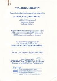
Flyer, Land Auction Advertisement, Talinga Estate, Allens Road, Heathmont, Vic. - 1985
Double sided A4 page with subdivision map showing location and size of allotments for auction on Saturday 3rd August (1985). Agent - C.E. Carter & Son Pty. Ltd., 122 Whitehorse Road, Ringwood 3134, Telephone 870 6211.Handwritten sale price annotations - Lot 1 Sold $42,000, Lot 2 Sold $42,200, Lot 3 Sold $41,500, Lot 4 Sold $53,000. -
 Greensborough Historical Society
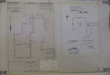
Planning Document, Subdivision Plan #1041. Elder Street Greensborough, 20/04/1983
Plan of Consolidation of Allotments 3 and 4 Brixton Avenue and Plan of Subdivision for Elder Street. An example of hard copy subdivision plans from the Greensborough area. Mainly from the Shire of Diamond Valley era (1964-1994).Plan (2 sheets) mounted on heavy card.Stamped and handwritten Council permissions, dates and other details.subdivision plans, elder street, brixton avenue -
 Greensborough Historical Society
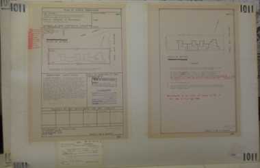
Planning document, Subdivision Plan #1011. Corner Mountainview Road and Hume Streets, 1981_
Plan of Strata Subdivision for units at corner of Mountainview Road and Hume Street Briar Hill.An example of hard copy subdivision plans from the Greensborough area. Mainly from the Shire of Diamond Valley era (1964-1994).Plan (2 sheets) mounted on heavy card.Stamped and handwritten Council permissions, dates and other details.subdivision plans, mountainview road, hume street -
 Greensborough Historical Society
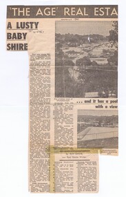
Newspaper - Newspaper Clipping, The Age, A Lusty baby Shire, 20/05/1967
An article about the new municipality "The Shire of Diamond Valley" and planned subdivision to the north of Greensborough.Bruce Morgan was the first Shire Secretary (1964-1983) of the Shire of Diamond Valley. This collection was compiled by his wife, Mavis Morgan, detailing the events they attended in their official capacityNews clipping, text and black and white imagesDate written in pen "SAT 20-5-1967"bruce morgan, mavis morgan, shire of diamond valley -
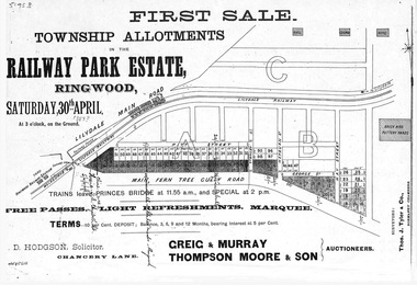 Ringwood and District Historical Society
Flyer, Subdivision advertisement - Railway Park Estate, Ringwood, Victoria - circa 1887
Photocopy of advertisement for auction sale of township allotments in Railway Park Estate, Ringwood, on Saturday 30th April (1887?), with terms of sale and location map.Subdivision map includes Pitt Street and Main Ferntree Gully Road (later Bedford Road). (Agents) Greig & Murray, Thompson Moore & Son, Auctioneers. -
 Kew Historical Society Inc
Plan - Subdivision Plan, Bella Vista Estate, 1929
Pru Sanderson, in her groundbreaking ‘City of Kew Urban Conservation Study : Volume 2 - Development History’ (1988), summarised the periods of urban development and subdivisions of land in Kew. The periods that she identified included 1845-1880, 1880-1893, 1893-1921, 1921-1933, 1933-1943, and Post-War Development. These periods were selected as they represented periods of rapid growth or decline in urban development. An obvious starting point for Sanderson’s groupings involved population growth and the associated economic cycles. These cycles also highlighted urban expansion onto land that was predominantly rural, although in other cases it represented the decline and breakup of large estates. A number of the plans in the Kew Historical Society’s collection can also be found in other collections, such as those of the State Library of Victoria and the Boroondara Library Service. A number are however unique to the collection.The Kew Historical Society collection includes almost 100 subdivision plans pertaining to suburbs of the City of Melbourne. Most of these are of Kew, Kew East or Studley Park, although a smaller number are plans of Camberwell, Deepdene, Balwyn and Hawthorn. It is believed that the majority of the plans were gifted to the Society by persons connected with the real estate firm - J. R. Mathers and McMillan, 136 Cotham Road, Kew. The Plans in the collection are rarely in pristine form, being working plans on which the agent would write notes and record lots sold and the prices of these. The subdivision plans are historically significant examples of the growth of urban Melbourne from the beginning of the 20th Century up until the 1980s. A number of the plans are double-sided and often include a photograph on the reverse. A number of the latter are by noted photographers such as J.E. Barnes.Bella Vista (later ‘Malinda’) was a large Federation house designed by the architect Robert Haddon for Abel Hoadley. The house was built in 1902 and occupied the eastern corner of Thomas Street and Cotham Road. It was a single-storey, red brick house, set back from the road, featuring a central tower topped by a pagoda-like red terra cotta roof, on top of which was perched a very large terra cotta dragon. The Bella Vista subdivision of 1929 included Hoadley’s house as well as nine allotments facing Cotham Road and Alfred and Thomas Streets. In 1941, the land on which Hoadley’s house stood was to be further subdivided. Bella Vista is believed to have lasted until it was demolished in the 1980s.subdivision plans - kew, bella vista estate -
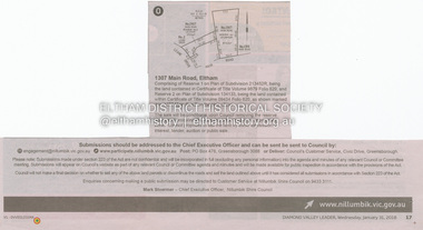 Eltham District Historical Society Inc
Document - Property Binder, 1307 Main Road, Eltham
Newspaper notice: Diamond Valley Leader, 31 January 2018, Calls for submissions re removal of reserve status and rezoning, Reserve 1 on Plan of Subdivision 213452R, Certificate of Title Volume 9879 Folio 829 and Reserve 2 on Plan of Subdivision 134133 Certificate of Title Volume 09434 Folio 620.main road, eltham, property -
 Glenelg Shire Council Cultural Collection
Newspaper - Newspaper article - Bridgewater Golf Club, Jul-92
Photocopy of article from Portland 'Observer', Friday July 10, 1992, in two halves, not joined together. Article headed 'Bridgewater Golf Club' and details proposed Heritage Valley country Club at Cape Bridgewater, as part of the Heritage Valley subdivision. -
 Bendigo Historical Society Inc.
Newspaper - ERROL BOVAIRD COLLECTION: ARTICLE TITLED HIGHLY SUCCESSFUL SPORT SYMPOSIUM
Newspaper article titled: Highly successful sport symposium with a photo of the vice-chairman of the SAMA Bendigo subdivision, Dr. Jan Sheringham and Elaine Bovaird secretary to the convention. Also the original of the photo published in the newspaper. Date on the back 11th October, 1980.newspaper, bendigo, sport symposium -
 Whitehorse Historical Society Inc.
Document, Gordon Crescent, 4/09/1890
Photocopy of Certificate of Title Vol. 2296 Fol 45903S, being part of Lots 46, 47 and 48, Plan of Subdivision No 2400, part Crown Portion 82 to Martha Quarterman 4 September 1890, transferred to Finlay Urquhart 5March 1946.gordon crescent, blackburn, central road, quarterman, martha, urquhart, finlay, land subdivision -
 Bendigo Historical Society Inc.
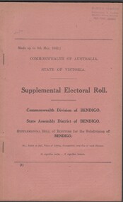
Administrative record - Electoral Roll, 1915
Voting registers, or electoral rolls, are a census of those who were eligible to vote. They are valuable because a country-wide census was not taken until 1911. Early electoral rolls give an individual’s name, residence, status of property occupation/ownership, and the rate value of the property. Electoral rolls are arranged by electoral district and subdistrict. Electoral rolls were published by each state during election years...Supplemental Electoral Roll for the Commonwealth Division of Australia Electoral Roll, State Assembly District of Bendigo, and Supplementary Roll of Electors for the Subdivision of Bendigo, 1943 (made up to May 1943). Includes Name, Address, Occupation and gender. Assembled and bound with string.Stamp of owner Harold Curnowelectoral rolls, voting in bendigo -
 Kew Historical Society Inc
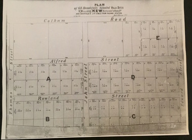
Plan - Subdivision Plan, Plan of 68 beautifully situated villa sites: St Helliers Kew, 196-1973
This work forms part of the collection assembled by the historian Dorothy Rogers, that was donated to the Kew Historical Society by her son John Rogers in 2015. The manuscripts, photographs, maps, and documents were sourced by her from both family and local collections or produced as references for her print publications. Many were directly used by Rogers in writing ‘Lovely Old Homes of Kew’ (1961) and 'A History of Kew' (1973), or the numerous articles on local history that she produced for suburban newspapers. Most of the photographs in the collection include detailed annotations in her hand. The Rogers Collection provides a comprehensive insight into the working habits of a historian in the 1960s and 1970s. Together it forms the largest privately-donated collection within the archives of the Kew Historical Society.A photographic reproduction of a plan in the Vale Collection of the State Library of Victoria. The plan shows lots in a subdivision bordered by Cotham Road; Edward Street; Sackville Street and Thomas Street. The undated plan does not include the land occupied by Bella Vista and Charleville.subdivision plans -- kew (vic), st helliers estate -
Kew Historical Society Inc
Plan, Gwen McWilliam, Annotated Plan of the City of Camberwell, 1993
Gwen Barton McWilliam (nee: Nelson), OAM, BA (1933- ). Gwen McWilliam is well known as an authority on the history of Boroondara and the author of a large number of books and pamphlets about the City. She was awarded the medal of the Order of Australia in 2001 ‘for service to the community of Hawthorn and district, particularly through the research, documentation and publication of its history.’ Plan of Camberwell, Canterbury, Balwyn and Surrey Hills, forming part of a larger plan of the City of Boroondara, including annotations by the historian Gwen McWilliam, identifying significant landholdings, subdivisions and key dates. The plan was donated to the Kew Historical Society by Ms McWilliam. city of boroondara, subdivisions - camberwell, subdivisions - balwyn, subdivisions - surrey hills, subdivisions - canterbury, gwen mcwilliam -
 Ringwood and District Historical Society
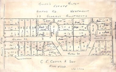
Pamphlet - Land Sales Brochure, Miller's Estate , Heathmont - circa 1950s
Hand-drawn land subdivision map with 33 allotments of the Miller's Estate on Allens Road, Milton Street, Heath Court and Mont Court, Heathmont. Sold by CE Carter & Son, Ringwood WU6024. (2 copies, one on blue cardboard backing.)LP28038 P/R 1954 -
 Greensborough Historical Society
Poster - Planning Document, Shire of Diamond Valley, Subdivision Plan # G 1, Watsonia, 1962 and 1976
Plan of Subdivisions in Shire of Diamond Valley: Side 1: subdivision of LP5406 bounded by Plenty Road, Greensborough Road, Meakin Avenue, Watsonia and includes Aqueduct Road, 1976. Side 2: 2 plans - Keelbundoora: Morwell Avenue and Grace Street; Nillumbik: Inglis Street and Chute Street Diamond Creek, 1962An example of hard copy subdivision plans from the Greensborough area. Mainly from the Shire of Diamond Valley era (1964-1994).Plan (2 sided) mounted on heavy card. Contains 2 sheets pasted together.Stamped and handwritten Council permissions, dates and other details. subdivision plans, diamond creek, shire of diamond valley -
 Kew Historical Society Inc
Photograph - East Kew, Looking Towards Balwyn, 1910-1930
Until post war subdivisions much of Balwyn and the eastern sections of Kew were rural farmlandVery large framed photographic enlargement of rural areas of East Kew. farmland (kew), kew farmland, farms, kew -
Canterbury History Group
Map - Canterbury Subdivisions
A collection of 6 maps with notations showing the names and dates of land subdivision in Canterbury and surrounding suburbs.canterbury, logans estate, shrublands estate, claremount park estate, arklow hill estate, griffin estate, monomeath estate, mont albert park estate, great railway estate, grange estate -
 Greensborough Historical Society
Photograph, Banyule Homestead 2011, 2000c
These photos were part of an objection to the proposed development and subdivision of part of the historic Banyule Homestead property.The Banyule Homestead dates from 1846, owned and built by Joseph Hawdon, sold in 1867 to Dr Martin. Leased to various farmers and eventually the land (274 acres) was subdivided in 1958. The Homestead presently sits on 2 1/2 acres of land. Set of 4 x A3 photos. Colour.Taken from western boundary overlooking lagoon.banyule homestead, joseph hawdon, heidelberg -
 Kew Historical Society Inc
Plan - Subdivision Plan, Old Kew Golf Links Estate - Third Section, 1920-1929
Pru Sanderson, in her groundbreaking ‘City of Kew Urban Conservation Study : Volume 2 - Development History’ (1988), summarised the periods of urban development and subdivisions of land in Kew. The periods that she identified included 1845-1880, 1880-1893, 1893-1921, 1921-1933, 1933-1943, and Post-War Development. These periods were selected as they represented periods of rapid growth or decline in urban development. An obvious starting point for Sanderson’s groupings involved population growth and the associated economic cycles. These cycles also highlighted urban expansion onto land that was predominantly rural, although in other cases it represented the decline and breakup of large estates. A number of the plans in the Kew Historical Society’s collection can also be found in other collections, such as those of the State Library of Victoria and the Boroondara Library Service. A number are however unique to the collection.The Kew Historical Society collection includes almost 100 subdivision plans pertaining to suburbs of the City of Melbourne. Most of these are of Kew, Kew East or Studley Park, although a smaller number are plans of Camberwell, Deepdene, Balwyn and Hawthorn. It is believed that the majority of the plans were gifted to the Society by persons connected with the real estate firm - J. R. Mathers and McMillan, 136 Cotham Road, Kew. The Plans in the collection are rarely in pristine form, being working plans on which the agent would write notes and record lots sold and the prices of these. The subdivision plans are historically significant examples of the growth of urban Melbourne from the beginning of the 20th Century up until the 1980s. A number of the plans are double-sided and often include a photograph on the reverse. A number of the latter are by noted photographers such as J.E. Barnes.When the old Kew Golf Links was subdivided in the mid 1920s, the developers were able to break the sale into sections. The third section included eighty lots. The lots faced Kilby Road, Kodak Avenue, Belford Road, Baker Avenue, Mathers Avenue, and White Avenue. [Kodak Avenue was renamed Page Avenue at a later date].The ‘Kew Conservation Study (1988) notes that ‘On the subdivision plan, Kodak’s involvement is commemorated by the naming of the streets after Company directors, and their decision to not proceed with the construction of the factory is explained as a response to the increase in the value of the land. This explanation may have been Estate Agent’s hyperbole, as the Kodak Company records suggest that the land, with its wide creek gully, was unsuitable and too small for its purposes.subdivision plans - kew, old kew golf links estate - third section -
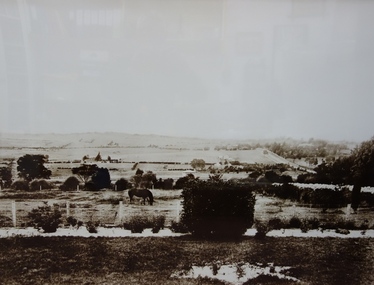
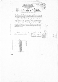
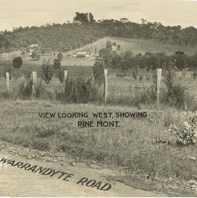 Ringwood and District Historical Society
Document - Property Titles, Transfer of Land Act - "Pinemont", Ringwood, Victoria
Folder containing copies of LANDATA documents relating to "Pinemont", Panorama Avenue, Ringwood, Victoria, compiled for potential real estate sales background information purposes. Title Vol 965 Fol 923 Allotment 27B Parish of Warrandyte - James Forbes, dated 30th August, 1876. Title Vol 5236 Fol 1947157 Lots 294 and 370 on Plan of Subdivision no.11392 - Anthony Loughnan, dated 4th March, 1927. Title Vol 6415 Fol 1282937 Lot 294 on Plan of Subdivision no.11392 - Jessie McCracken Rothwell Woodard, dated 9th September, 1940. -
Ringwood and District Historical Society
Legal record - Conditions of Sale (C.E. Carter), Ringwood Electric Railway Estate, Lots 98 and 99, Sale to Tilbury and Albon, 1925
Original Particulars and Conditions of Sale document by C.E. Carter & F. H. Patterson & Co, to B.C. Tilbury Esq and A.J.Albon Esq: Lots 98 and 99, Electric Railway estate, Ringwood Plan of Subdivision 9473, Crown Portion 18, Parish of Ringwood. -
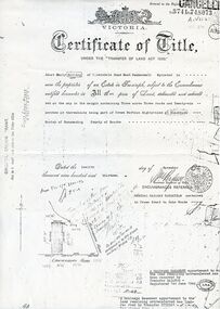
 Whitehorse Historical Society Inc.
Administrative record - Document, Certificate of Title, 1/09/1909
Photocopy of Certificate Vol. 3352 Fol 335 to Freehold Assets Co Ltd 29 September 1909 for fifty acres fronting on South Side of Canterbury Road, part Crown Portion 94; including record of subdivision transfers 1909 - 1916 and 1992.land subdivision, .freehold assets company limited, glebe street forest hill, crittle, thomas nathaniel, henwood, william, mcarthur, john, draeger, carl julius otto, jay, daniel, barnes, john thomas, mary ann, kleinert, beatrice annie, stanley ernest -
 Whitehorse Historical Society Inc.
Document, Land purchase Certificate of Title, 12/11/1913 12:00:00 AM
Plan of subdivision of land in the Shire of Nunawading which includes 'Wandinong'.Plan of subdivision of land in the Shire of Nunawading which includes 'Wandinong'. Copy of Certificate of Title of Crown Grant to Janet Emily Hooke, nee Billing, dated 12/11/1913, also purchase of land by J. Woods dated 31/3/1856.Plan of subdivision of land in the Shire of Nunawading which includes 'Wandinong'. haines, william, woods, john, hooke, janet emily, billing, wandinong sanctuary, canterbury road, blackburn, blackburn road -
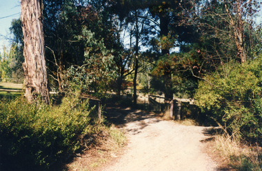 Whitehorse Historical Society Inc.
Photograph, Casella Street, Mitcham 1993
Photos show the last small rural property in Mitcham before subdivision. The property was owned by the Moore familySet of 3 coloured photographs of Casella Street, Mitcham, taken in 1993 before the area was subdivided for housingcasella street, mitcham -
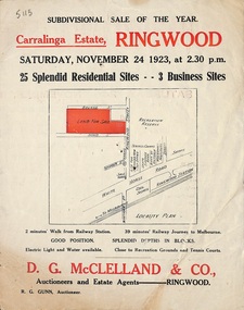 Ringwood and District Historical Society
Flyer, Subdivisional Auction Sale Brochure, Carralinga Estate, Ringwood, Vic. - 1923
Double sided folded page with black and red print on both sides advertising auction sale of residential and business sites and highlighting local facilities, services and layout of the estateSubdivision includes Ringwood Street, Bourke Street and Bond Street. (Agent) D.G. McClelland & Co., Auctioneers and Estate Agents. Phone 37. R.G. Gunn, Auctioneer. -
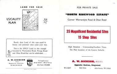 Ringwood and District Historical Society
Flyer, Land Sale Brochure, North Ringwood Estate, Ringwood, Vic. - 1958
Double-sided land sale advertisement for sale of 35 residential and 15 shop sites on the corner of Warrandyte Road and Oban Road, Ringwood North, Vic., including locality plan and features of the estate.Subdivision includes Oban Road, Warrandyte Road, and Dickson Crescent. Agent: A.W. Dickson, Opposite Station, Ringwood. (Phone) WU6007, WU7016, after hours WU6868. -
 Tatura Irrigation & Wartime Camps Museum
Document, Certificate of Payment - John Donaldson
Certificate of payment to John Donaldson, vol 1519 folio 303692, memorials of instruments and titles office record of subdivision.3 pages of copies of original paperwork relating to J Donaldson ownership of land.john donaldson, vol 1519 folio 303692, memorials of instruments, titles office record of subdivision, certificate of payment -
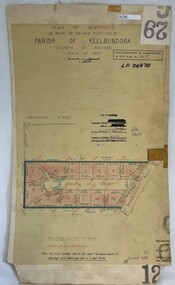 Greensborough Historical Society
Poster - Planning Document, City of Heidelberg, Subdivision Plan # G 29 Part 2, Crown portion 16, Greensborough, 1951
Plan of Subdivisions in City of Heidelberg: Parish of Keelbundoora: Crown portion 16 - Daours Court and Devonshire Road, 1951.An example of hard copy subdivision plans from the Greensborough area. Mainly from the Shire of Diamond Valley era (1964-1994).Plan (single sided) mounted on heavy card. Stamped and handwritten Council permissions, dates and other details.subdivision plans, city of heidelberg -
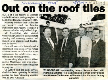 Whitehorse Historical Society Inc.
Article, Out on the roof tiles, 1994
Parts of Monier Wunderlich tile factory in Vermont may be listed on a heritage register of the Historic Buildings Council.Parts of Monier Wunderlich tile factory in Vermont may be listed on a heritage register of the Historic Buildings Council. City of Nunawading has recently introduced a front desk service where residents can obtain information about requirements for subdivisions, engineering and building permits.Parts of Monier Wunderlich tile factory in Vermont may be listed on a heritage register of the Historic Buildings Council. tile factories, monier wunderlich tile factory, historic buildings, abbott, kevin, maclellan, rob, strong, ray, tuckerman, graeme -
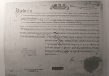
Whitehorse Historical Society Inc.
Map, Township of Norwich, ca 1850
Plan of the Township of Norwich being subdivision of Section III, Parish of Nunawading, County of Bourke, consisting of suburban farms, vineyard sites and town lots, for sale by auction by W. Casey & Co. [c. 1850]. Original in Vale Maps Collection, La Trobe Library.norwich village, vermont, parish of nunawading, vermont south, maps