Showing 857 items matching "surveyor"
-
 Bendigo Historical Society Inc.
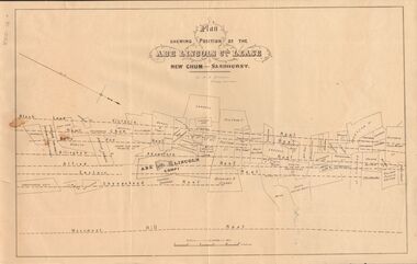
Document - MARKS COLLECTION: ABE LINCOLN CO LEASE
Two copies of plan for Abe Lincoln Co. Lease, New Chum, Sandhurst. One original, one copy. On top of plan 'Plan Showing Position of the Abe Lincoln Co. Lease, New Chum, Sandhurst' under name 'by H.B. Nicholas, Mining Surveyor' Sheepshead Reef, Easter reef, Alfred Reef, Allingham Reef,Adventure Reef, Belle Vue Reef, New Chum Reef, Black Lead, Victoria Reef lines shown on map with mine leases marked. On bottom of map 'Monument Hill Reef' line marked.bendigo, mining, abe lincoln lease -
 Glen Eira Historical Society
Article - COANE, JOHN MONTGOMERY
This file contains one item about Coane and his family: 1/A one page extract from The Australian Dictionary of Biography Vol. 8 page 35 on John Montgomery Coane, Surveyor and Consulting Engineer, his partnership with George Hudson and later when his two sons joined the business. It details many of the projects he designed for rural Victoria and New South Wales and his other areas including Consulting to The Pacific Phosphate Co. Ltd of London and to the City of Brighton where he lived.coane john montgomery, blacker’s orchard & cannery co., victorian institute of surveyors, county donegal, ireland, mordialloc, ballyshannon, mines department sludge abatement board, coane henry edward, surveyors, engineers, land surveyors board, coane henry james, j.m. and h.e. coane, coane jane nee montgomery, coane john montgomery junior, victorian education department, australian roads, collas emma anna hunt, books, grant george hudson, coutie b.m., state electricity of victoria, melbourne, epsom racecourse, racecourses, brighton, city of brighton, brighton re-adaptation society, brighton cemetery, cemeteries, southern roger j, australian dictionary of biography vol. 8, early settlers -
 Federation University Historical Collection
Book, Railway Practice: a collection of working plans and practical details of construction in the public works of the most celebrated engineers, 1847 (exact)
A green cloth hard cover book. Title and author's name are engraved in gold on spine. This is the 3rd edition, first series with black and white illustrations. It describes the engineering practices of the early days of British railroads. The book includes (series 1 to 4)and it contains, roads, tramroads and railroads, bridges, aqueducts, viaducts, wharfs, warehouses, roofs, and sheds, canals, locks, sluices, & the various works on rivers, streams, etc., harbours, docks, piers and jetties, tunnels, cuttings and embankments, the several works connected with the drainage of marshes, marine sands, and the irrigation of land, water-works, gas-works, water-wheels, mills, engines.civil engineering, railway practice, rail constructions, s c brees, western railway great britain, public works, railroads, canals, s.c. brees, samuel brees, samuel charles brees -
 Federation University Historical Collection
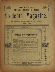
Booklet, Ballarat School of Mines, Student Magazine, Third Term, 1901, 1901
Articles include: Concentrating difficult silver-lead ores, Estimation of chlorine, bromine and iodine (by D.Runting. Summaries and notes from the technical journals, Notes upon the use and care of platinum ware, Common sense, The machinery at the Tasmania gold mine, Beacons-Field, Tasmanina, Mining at Walhalla - The long tunnel mine, Past students, Mapping out of agricultural areas &c., in dense vine lands, North Queensland (by R. A. Suter. Licensed surveyor, Queensland and Victoria), News and notes, Concert balance sheet, Editorial notices.Soft covered magazine of 16 pages. silver-lead ores, estimation of chlorine, bromine and iodine (by d.runting), platinum ware, tasmania gold mine, beaconsfield, tasmania, mining at walhalla, long tunnel mine, vine lands, north queensland, r. a. suter, photography class, boer war, alumni, thomas vincent, basil sawyer, o. e. jager, a. s. burdekin, t. phillipson, glen macpherson, tom uthwatt, marcus marks, r. j. allen, cecil eales, cecil wakley, adam morton, e.p. lewers, harry leggo, jack hill, berk, nickolls, h. burrows, percy osborne, j. brangan, chris evans, adamson, alford, r. evans, arthur "thomas" atkins, charles campbell, hardy, a. basil reid, h. l. krause, k. grant, m. gray, a.b. reid, h. alston, playford, j. a. reid, s. b. vial, f. a. marriott, f. lush, c. whyte, karl moore, r. robin, w. j. lakeland, e. trend, h. l. giles, r. mccracken, k. bryron moore -
 Kew Historical Society Inc
Photograph - 'Fernhurst', 13 Fernhurst Grove, 1978
George Wharton arrived in Melbourne in 1844. An architect and surveyor, he was appointed to lay out the 'Village of Kew' by N.A. Fenwick following the land sales of 1851. A protagonist for Kew's separation from the Boroondara District Road Board, he was elected chairman when Kew achieved municipal status in December 1860. His home, 'Fernhurst', was built in 1866 on eight acres in Studley Park, with a four-storey tower and pyramidal roof. The Italianate home was a prominent Kew landmark. It was demolished in 1979 and replaced by St Paul's College in 1980.Rare colour photograph of what was once a significant mansion in Kew.Original colour positive photograph (Kodak print) of 'Fernhurst' in 1978. Photographed by Stewart West in May 1978, one year before it was demolished, the photograph gives little idea of the large landholding once surrounding the house. Originally accessed from near the corner of Princess Street and Studley Park Road, its gardens had been subdivided in the 1900s and its footprint restricted to 13 Fernhurst Grove. Like many other grand houses, by the 1970s it had been converted into apartments. From the photograph, one can see that the house had retained many of its original features such as the distinctive tower and the wide bow-fronted verandah. The slates on the roof (apart from those on the tower) had been replaced by tiles and the cement render of the exterior painted white. Annotated reverse: "View of Fernhurst Home Taken from Street / 10"fernhurst, 13 fernhurst grove -- kew (vic.), george wharton, italianate architecture, vila maria society, st paul's school for the blind -
 Kew Historical Society Inc
Photograph - 'Fernhurst', 13 Fernhurst Grove, 1978
George Wharton arrived in Melbourne in 1844. An architect and surveyor, he was appointed to lay out the 'Village of Kew' by N.A. Fenwick following the land sales of 1851. A protagonist for Kew's separation from the Boroondara District Road Board, he was elected chairman when Kew achieved municipal status in December 1860. His home, 'Fernhurst', was built in 1866 on eight acres in Studley Park, with a four-storey tower and pyramidal roof. The Italianate home was a prominent Kew landmark. It was demolished in 1979 and replaced by St Paul's College in 1980.Rare colour photograph of what was once a significant mansion in Kew.Original colour positive photograph (Kodak print) of 'Fernhurst' in 1978. Photographed by Stewart West in May 1978, one year before it was demolished, the photograph gives little idea of the large landholding once surrounding the house. Originally accessed from near the corner of Princess Street and Studley Park Road, its gardens had been subdivided in the 1900s and its footprint restricted to 13 Fernhurst Grove. Like many other grand houses, by the 1970s it had been converted into apartments. From the photograph, one can see that the house had retained many of its original features such as the distinctive tower and the wide bow-fronted verandah. The slates on the roof (apart from those on the tower) had been replaced by tiles and the cement render of the exterior painted white. Annotated reverse: "Fernhurst from higher ground level side shot / 7"fernhurst, 13 fernhurst grove -- kew (vic.), george wharton, italianate architecture, vila maria society, st paul's school for the blind -
 Kew Historical Society Inc
Photograph - 'Fernhurst', 13 Fernhurst Grove, 1978
George Wharton arrived in Melbourne in 1844. An architect and surveyor, he was appointed to lay out the 'Village of Kew' by N.A. Fenwick following the land sales of 1851. A protagonist for Kew's separation from the Boroondara District Road Board, he was elected chairman when Kew achieved municipal status in December 1860. His home, 'Fernhurst', was built in 1866 on eight acres in Studley Park, with a four-storey tower and pyramidal roof. The Italianate home was a prominent Kew landmark. It was demolished in 1979 and replaced by St Paul's College in 1980.Rare colour photograph of what was once a significant mansion in Kew.Original colour positive photograph (Kodak print) of 'Fernhurst' in 1978. Photographed by Stewart West in May 1978, one year before it was demolished, the photograph gives little idea of the large landholding once surrounding the house. Originally accessed from near the corner of Princess Street and Studley Park Road, its gardens had been subdivided in the 1900s and its footprint restricted to 13 Fernhurst Grove. Like many other grand houses, by the 1970s it had been converted into apartments. From the photograph, one can see that the house had retained many of its original features such as the distinctive tower and the wide bow-fronted verandah. The slates on the roof (apart from those on the tower) had been replaced by tiles and the cement render of the exterior painted white. Annotated reverse: "Back view of Fernhurst / 8"fernhurst, 13 fernhurst grove -- kew (vic.), george wharton, italianate architecture, vila maria society, st paul's school for the blind -
 Kew Historical Society Inc
Photograph - 'Fernhurst', 13 Fernhurst Grove, 1978
George Wharton arrived in Melbourne in 1844. An architect and surveyor, he was appointed to lay out the 'Village of Kew' by N.A. Fenwick following the land sales of 1851. A protagonist for Kew's separation from the Boroondara District Road Board, he was elected chairman when Kew achieved municipal status in December 1860. His home, 'Fernhurst', was built in 1866 on eight acres in Studley Park, with a four-storey tower and pyramidal roof. The Italianate home was a prominent Kew landmark. It was demolished in 1979 and replaced by St Paul's College in 1980.Rare colour photograph of what was once a significant mansion in Kew.Original colour positive photograph (Kodak print) of 'Fernhurst' in 1978. Photographed by Stewart West in May 1978, one year before it was demolished, the photograph gives little idea of the large landholding once surrounding the house. Originally accessed from near the corner of Princess Street and Studley Park Road, its gardens had been subdivided in the 1900s and its footprint restricted to 13 Fernhurst Grove. Like many other grand houses, by the 1970s it had been converted into apartments. From the photograph, one can see that the house had retained many of its original features such as the distinctive tower and the wide bow-fronted verandah. The slates on the roof (apart from those on the tower) had been replaced by tiles and the cement render of the exterior painted white. Annotated reverse: "Fernhurst front view taken from across Fernhurst Grove / 6"fernhurst, 13 fernhurst grove -- kew (vic.), george wharton, italianate architecture, vila maria society, st paul's school for the blind -
 Kew Historical Society Inc
Photograph - 'Fernhurst', 13 Fernhurst Grove, 1978
George Wharton arrived in Melbourne in 1844. An architect and surveyor, he was appointed to lay out the 'Village of Kew' by N.A. Fenwick following the land sales of 1851. A protagonist for Kew's separation from the Boroondara District Road Board, he was elected chairman when Kew achieved municipal status in December 1860. His home, 'Fernhurst', was built in 1866 on eight acres in Studley Park, with a four-storey tower and pyramidal roof. The Italianate home was a prominent Kew landmark. It was demolished in 1979 and replaced by St Paul's College in 1980.Rare colour photograph of what was once a significant mansion in Kew.Original colour positive photograph (Kodak print) of 'Fernhurst' in 1978. Photographed by Stewart West in May 1978, one year before it was demolished, the photograph gives little idea of the large landholding once surrounding the house. Originally accessed from near the corner of Princess Street and Studley Park Road, its gardens had been subdivided in the 1900s and its footprint restricted to 13 Fernhurst Grove. Like many other grand houses, by the 1970s it had been converted into apartments. From the photograph, one can see that the house had retained many of its original features such as the distinctive tower and the wide bow-fronted verandah. The slates on the roof (apart from those on the tower) had been replaced by tiles and the cement render of the exterior painted white. Annotated reverse: "Front view of Fernhurst showing tower to advantage / 9"fernhurst, 13 fernhurst grove -- kew (vic.), george wharton, italianate architecture, vila maria society, st paul's school for the blind -
 Kew Historical Society Inc
Photograph - 'Fernhurst', 13 Fernhurst Grove, 1978
George Wharton arrived in Melbourne in 1844. An architect and surveyor, he was appointed to lay out the 'Village of Kew' by N.A. Fenwick following the land sales of 1851. A protagonist for Kew's separation from the Boroondara District Road Board, he was elected chairman when Kew achieved municipal status in December 1860. His home, 'Fernhurst', was built in 1866 on eight acres in Studley Park, with a four-storey tower and pyramidal roof. The Italianate home was a prominent Kew landmark. It was demolished in 1979 and replaced by St Paul's College in 1980.Rare colour photograph of what was once a significant mansion in Kew.Original colour positive photograph (Kodak print) of 'Fernhurst' in 1978. Photographed by Stewart West in May 1978, one year before it was demolished, the photograph gives little idea of the large landholding once surrounding the house. Originally accessed from near the corner of Princess Street and Studley Park Road, its gardens had been subdivided in the 1900s and its footprint restricted to 13 Fernhurst Grove. Like many other grand houses, by the 1970s it had been converted into apartments. From the photograph, one can see that the house had retained many of its original features such as the distinctive tower and the wide bow-fronted verandah. The slates on the roof (apart from those on the tower) had been replaced by tiles and the cement render of the exterior painted white. Annotated reverse: "Fernhurst corner shot through trees / 12-22"fernhurst, 13 fernhurst grove -- kew (vic.), george wharton, italianate architecture, vila maria society, st paul's school for the blind -
 Williamstown Botanic Gardens- Hobsons Bay City Council
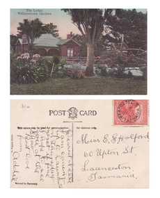
Postcard – Williamstown Botanic Gardens, M Schulz, Prague, c1900-1920
The original postcards in this series (2013.002 to 2013.018) were generously loaned to Williamstown Botanic Gardens by a private collector for copying. The logo in the middle of the words ‘POST CARD’ indicates the card was printed by M. Schulz in Prague. Schulz was a long-established company from Prague and printed postcards for customers from worldwide. Schulz printed in photo-chromolithography. The Curator’s lodge, designed by the Town Surveyor, HV Champion, was constructed in 1907 following the re-organisation of the north-east corner with the demolition of the old curator's cottage and erection of new gates. The postcards are evidence of the interest the gardens held as a subject for postcard publishers. The text and images provide a snapshot into fashions, social interests and concerns of the time. The professionally produced images provide a pictorial history of Gardens including changing planting styles, various structures and features of the Gardens eg the aviary, cannons, the fountain, the second Curator’s Lodge and gates. The images offer an opportunity to compare garden vistas with the present day. The card also demonstrates how postcards were used as a method of contact in contrast to the contemporary use as souvenirs. A colour image of a house (the Curators lodge) behind a fence with two children sitting on it. There are two large Cordylines, one in the forefront of the image standing in lawn and surrounded by pink flowers, and one closer to the house. The house is brown timber with two brick chimneys and has a green corrugated iron roof with gables over the windows at the front and side.Front: ‘The Lodge, / Williamstown Gardens’. Reverse: Centre top ‘POST CARD’ with a logo [MS] in the middle of the words; left side vertical ‘O. Rippon Series’; left side ‘This space may be used for communication.’; right side ‘For Address only.’; left side bottom ‘Printed in Germany’. There is a one penny red Tasmanian stamp on the top right hand corner. The card is addressed to ‘Miss E G Holford / 60 Upton St, / Launceston, / Tasmania.’ Top left corner in pencil ‘$10’ (believed to be inserted by the vendor.postcard, gardens, post-card, williamstown-botanic-gardens, hobsons-bay-city-council, curator’s lodge, children, cordyline -
Glenelg Shire Council Cultural Collection
Functional object - Survey Marker - Tyers' Surveyors' bearings slab, n.d
Displayed in History House.Wooden slab, painted white, carved inscription on face. Encased in wooden case with glass front.Front: LAT. 38. 21.34 S/Long. 141.41E/Var 5.30E (front, incised) Back: (from previous worksheet) Remains of Sheoak Stump from Allot 5 St Portland with lat de and long de cut in by Govt. Surveyor in the year 1840/T.W. 21-4-1900 (black print) -
 Kiewa Valley Historical Society
Map - Topographical, Ski Club of Victoria Bogong High Plains and Adjacent Peaks, Early 1930's
This map has been in the Ryder family for approx. 70 years. Probably used when bush walking and skiing in the early days on the Bogong High Plains. The Ryder family are farmers in the Kiewa Valley and were involved in taking their cattle up to the Bogong High Plains where they had a lease. The State Electricity Commission of Victoria constructed the Kiewa Hydro Electric Scheme opening up the area during the 1940's and 1950's. This type of map is an early one, used by people in the Kiewa Valley and possibly by surveyors prior to construction.The map is an early topographic map used by farmers living in the Kiewa Valley. It is historically significant as these people were involved in taking cattle up to the High Plains during summer and may have been used for bush walking and skiing.This is a sepia coloured paper map which was originally printed copyright registered. It was revised in 20/6.33/4.4.37/8.4.40/24.8.43/19/6/54. It shows roads / tracks / snow poles / snow pole numbers (27) / Snow pole spacing (3 chains. 66 yards) approximately 27 poles to the mile / height above sea level in feet - 5280. Water courses not definitely located etc.Rocky Valley Dam (Kiewa Hydro Electric Scheme) has been drawn on the map by hand with a biro. There is a wooden rod at the top of the map.topographic map; kiewa valley; ryder family; high plains of victoria -
 Tarnagulla History Archive
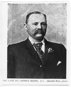
Photograph: copy of news image of George Minto, c. 1870s
Murray Comrie Collection. George Minto (b.1824 in Harwick, Scotland) was engineer at the Flour Mill in Tarnagulla, was Mayor of Tarnagulla Borough Council for a time and was engineer of the Shire of Marong for twenty years. For 13 years he occupied the position of surveyor to the Bendigo City Council. In his later life he lived in Kangaroo Flat. Whilst living there, on the 28th November 1914, he died, aged 90 and a half years. This photograph is a reasonable image created from a historic news source (unknown). Copy probably made by Murray Comrie in the 1970s.Monochrome photograph, being copy of a news clipping with image of George Minto. Printed caption 'The Late Mr. George Minto, Jun. (Bartlett Bros, photo)'. tarnagulla, people -
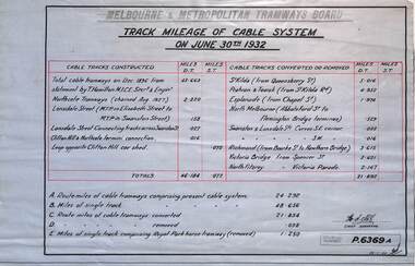 Melbourne Tram Museum
Drawing, Howard McComb, MMTB Track miles - cable and electric, 30/6/1932
Drawing prepared by H McComb, MMTB Surveyor, dated 30/6/1932 comprising three separate sections prepared on one sheet. Scans have been done of each section. Gives details: P6369A - Track mileage of cable system - miles of cable trams constructed, converted or removed - miles double track and single track. P6369B - Track mileage of electric system - tracks constructed and available for traffic and tracks constructed by not available for traffic P6369C - Track mileage of electric system - car sheds, workshops and store yards.Yields information about the MMTB system and its mileages in 1932.Drawing -black and red ink on linen.trams, tramways, mmtb, mileages, cable trams, electric trams, depots, workshops -
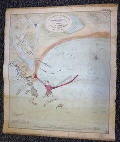 Warrnambool and District Historical Society Inc.
Map - Warrnambool Port 1879, 1879
The port facilities in Warrnambool Bay were in constant use from the first years of Warrnambool’s settlement but there were also difficulties for the shipping trade – a small and unsafe anchorage, the lack of loading facilities and little natural protection from the southerly gales. From the 1870s on there was local agitation for some sort of Breakwater to be built and an Andrew Kerr design was approved by the Warrnambool Council but no funds were made available from the Victorian Government. Throughout the 1870s the building of a Breakwater was a major political issue in the district with preliminary work being funded and started in 1874. In 1879 the Government agreed to a further inspection of the area and an official report. Sir John Coode (1816-1892) was commissioned to make this report. He had come to Australia in 1872 to advise on harbour construction. Coode recommended a 1800 feet long Breakwater and wharf connected to the shore and it was this proposal that the plan described herein and drawn up in 1879 was to accompany. The original plan was eventually modified because of the cost and a Breakwater was completed in 1890 under the direction of the engineer, Arthur Dudley Dobson, with extensions early in the 20th century. This plan is of great interest as it shows in simple graphic form the original plans proposed by Sir John Coode for the Warrnambool Breakwater. It is therefore of great historical importance. The Breakwater was not the maritime success that it was hoped it would be but it is today a significant feature of our foreshore. This is a Plan drawn up in 1879 by Victorian Harbours to accompany Sir John Coode’s Report on the proposed Warrnambool Breakwater. The chart detail is hand-drawn and hand-tinted on canvas with the names of places, geographical and marine features and local points of interest added in print. The edges of the chart are rubbed and the chart is somewhat faded and dirty but the main colours of red, green and brown are still clearly discernible. The title of the plan is printed in an oval inset at the top of the chart. The plan shows two possible Breakwater designs, one from the Borough Surveyor (Andrew Kerr?) and one from Sir John Coode.Victorian Harbours Warrnambool Plan to accompany Sir John Coode’s report Dated 28th Feby 1879 warrnambool breakwater, andrew kerr, sir john coode, arthur dudley dobson, warrnambool, warrnambool harbour, warrnambool history, warrnambool beach -
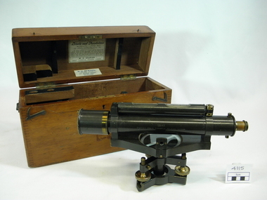 Federation University Historical Collection
Instrument, W. H. Stanley, Surveying level, July 1899
Used by students attending surveying classes at the School of Mines & Industries, Ballarat.Surveyor's level caste in metal with brass trimmings. Features external focus, twin inclined vertical crosshairs with stadia wires. With ray-shade clinomenter. Three levelling screws. Without transverse level (mounting provided). dust shield for object. Features glass lens x 2. Timber carry case features dovetailed joints, separate lid attached to body of case with two brass piano hinges along back side. Case has a metal carry handle screwed to each end. Matches tripod Item 4116 Item's serial number: 99142*The timber lid of the carry case has 'L3' painted on it in white paint. *The paper label glued to reverse side lid of inside carry box reads: STANLEY'S PATENT LEVELS AND THEODOLITES No.99142 July 1899 STADIA POINTS SET=1 : 100. In taking readings of a distant staff by means of the subtense points in the diaphragm, read every 1/100 foot (or metre) on the staff as being equal to one foot (or metre) of distance from the centre of the instrument adding to the reading of plus constant of 18 3/4 inchess from any distance shown. W.F. Stanley, Great Turnstile, Holborn, London. *The paper label glued to lower edge inside lid of carry box reads: N. H. SEWARD, "Optical House" 457 BOURKE STREET (Near Queen Street) MELBOURNE *Engraving on brass plate encompassing the catch on front edge of the timber carry case reads: H&C L (inside an engraved heart on LSH) EUCHRE LEVER (engraved on RHS of brass plate) *Maker's mark is engraved along the length of the telescope barrel: 99142 Stanley. Great Turnstile Holborn, London. level, theodolite, surveying instrument, surveying, scientific instruments -
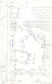 Ringwood and District Historical Society
Document - Copy of Lands Department Field Notes - Parish of Ringwood, Victoria, Field Notes - 1928/453 - Part of OP R72C Surveyed on 17.11.1928
5616b Foolscap size photocopy of survey map with handwritten notations. References include Whitehorse Road, Mines Road, Wilson Street, Rupert Street, New Road (Braeside Avenue), Section E, Allot 31 sold, Allot 32 sold, Recreation Reserve, Allot 25 sold, Allot 29 sold, hedge, spikes, links on line from each corner, I hereby certify that these field notes were prepared from actual observations and measurements made by me or under my supervision on the ground and in accord with regulations (signed) Authorised Surveyor 17/11/28. -
 Bendigo Historical Society Inc.
Slide - DIGGERS & MINING. LIFE OF THE SELECTORS, c1860
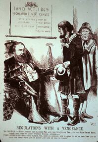
Diggers & Mining. Life Of The Selectors. Land Act 1869. Sign reads; Regulations 49th Clause, other details listed. Regulation With A Vengeance. Mr McKean - ''Then there's the license fee, and the surveyors fee, and the half years rent, which will come to fifteen pounds, besides -- '' Free Selector. - Beg your pardon, sir hope no offence. But seems to me that this. New act is only for them with lots of money and lots of time to waste. Markings; Diggers & Mining. Life Of The Selectors 1860-1890 Set 432 No. 17. Regulations with a Vengeance- ''Melbourne Punch,'' Feb, 10,1870. Used as a teaching aid.Visual Education Centreeducation, tertiary, goldfields -
Bendigo Historical Society Inc.
Map - MAP PORTION OF BENDIGO GOLDFIELD, Circa 1912
Map: Portion of Bendigo Goldfield showing Sheepshead, Deborah, Garden Gully, Paddy's Gully and Derby lines of reef. Showing statistical records of all the Companies on these lines. Issued by Wood and McNair, Sharebrokers, Bendigo and Eaglehawk. The map illustrates the main lines of reef as they appeared with mines and details of their calls and dividends as well as gold produced. Drawn by mining surveyor and geologist William Henry Cundy, who trained and worked for the Tasmanian Mines Department until 1893, when he moved and settled in Bendigo. Cundy was responsible for the surveying of the southern end of the field of Diamond Hill and beyond.topic, mining, companies, bendigo goldfield, sheepshead , deborah, garden gully, paddy's gully derby, wood and mcnair -
 Warrnambool and District Historical Society Inc.
Document, Map: Lady Bay 1853, 1853
This is one of the earliest surveys and maps of Warrnambool harbor, Lady Bay. Being done in 1853, it shows the depths of the bay area marked in fathoms, currents and directions and areas of rocks around mouth of the Merri and the Western side of the bay as well as a large sand spit to the middle right of the beach region.. It also marks the large areas of seaweed and fuci in the outer bay area. It has the area of Pertobe Lagoon marked and shows the early tracks to the town. The engraving work was done by Tulloch and Brown, with Tulloch being one of the earliest engravers and lithographers in the state of Victoria. He arrived in Melbourne in 1849 and set up business with James Davie Brown in 1853 with Brown being a map engraver. They were awarded bronze and silver medals for their work at the Victorian Industrial Exhibition. He also worked in the vignettes on the Proeschel Map of Victoria.This map is of high historical and comparitive significance as it shows the Lady Bay area prior to the changes that have occurred in the last 160 years with the building of the breakwater. The issue regarding access to Lady Bay remains a current one. The engraver D Tulloch engraved some of the earliest scenes of the goldfields in Ballarat and as such has left a record of a very early and important era in Australian history. Rectangular cream paper with black text. Map area is outlined by fine black lined border. Key in top right hand corner and scale at bottom middle of map.Map is labelled Town of Warrnambool printed at top of map. Small logo at top right corner which has “Hydrographic Department” in circle around an anchor. Lady Bay Warrnambool Surveyed by John Barrow assistant surveyor Engraved by Tulloch & Brown in bottom right corner. Melbourne engraved by order of the legislative Council of Victoria in middle bottom.map, warrnambool, town of warrnambool map 1853, tulloch & brown map 1853, lady bay warrnambool,, warrnambool harbour, warrnambool breakwater, warrnambool beach -
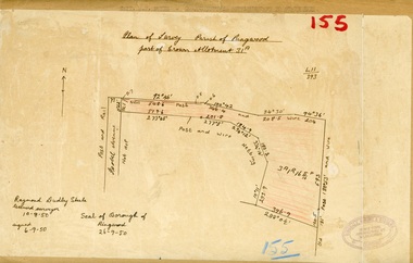 Ringwood and District Historical Society
Map, Plan of Survey, Parish of Ringwood - Part of Crown Allotment 31A - 1950
Hand drawn and labelled copy of map with survey measurements of allotment on Isobel Avenue (Isabel Avenue?), Ringwood East. Raymond Dudley Steele Licensed Surveyor 10-8-50, signed 6-9-50, Seal of Borough of Ringwood 26-9-50. Rubber stamp - Dugdale, Simmons & Stevens, Solicitors, Peacock House, 486 Bourke Street Melbourne. Typewritten heading on backing paper - Capt. M.H. Moyes - Correspondence Supplementary to Statements. -
 Ringwood and District Historical Society
Document - Map, Part of Crown Allotment 27C, Parish of Warrandyte, County of Evelyn, Ringwood, Victoria - c.1970
Photocopy of subdivision plan 75131 Vol 3439 Fol 712 showing numbered residential allotments with property dimensions.Surveyors and Consulting Engineers - O'Connor & Beveridge, Main Eltham Road, Lower Plenty, Tel. 432668. Rubber-stamped "Photocopy - Titles Office Complied 17 Feb 1970". Map includes Lockhart Road, Lansell Close, Terrara Place, Goldsmith Avenue, Park Hill Drive, Hilldale Close, and Elm Court, Ringwood, Victoria. -
 Ringwood and District Historical Society
Document - Plan of Subdivision, Part of Crown Allotment 31B, Parish of Warrandyte - 1965
Map showing residential allotments numbered 1, 2, 4 and 5, on Through Road, Ringwood, Vic., with property dimensions, including weatherboard house and galvanised iron garage on lot 2.Kirkpatrick & Webber, Licensed Surveyors, Civil Engineers & Town Planners, Maroondah Highway, Ringwood, Telephone 8700321. Ref 3438C. Date 4th December, 1964. Amended 19th July, 1965. Notation: "The land coloured blue is a drainage and sewerage easement. Levels are to Board of Works Datum. Lot number 3 has been omitted." -
Queenscliffe Maritime Museum
Equipment - Engine room telegraph
Court of Marine Inquiry found that steering gear had failed as vessel entered Heads. Fault lay with Lloyd's surveyor for not detecting fault. Vessel had been classified Al. No blame attachable to master. Two Queenscliff fishermen purchased wreck for 950 pounds (insured value 30,000 pounds)and its timber cargo - handsome profit. Cargo and most fittings of value recovered. Wreck visible until early 1960s, until during a storm it slid off northern side of Nepean reef and broke up in 20 feet of water. The most noteworthy shipwreck to date at the heads.Ship's engine room telegraph from bridge of SS TimeChadburns ship's telegraph manufacturersss time, wrecks, marine telegraph -
 Kew Historical Society Inc
Photograph - Cosy Five Roomed Rough Cast Bungalow, Kew, J E Barnes, c.1920
Subdivision plans are historically important documents used as evidence of the growth of suburbs in Australia. They frequently provide information about when the land was sold on which a built structure was subsequently constructed as well as evidence relating to surveyors and real estate and financial agents. The numerous subdivision plans in the Kew Historical Society's collection represent working documents, ranging from the initial sketches made in planning a subdivision to printed plans on which auctioneers or agents listed the prices for which individual lots were sold. In a number of cases, the reverse of a subdivision plan in the collection includes a photograph of a house that was also for sale by the agent. These photographs provide significant heritage information relating house design and decoration, fencing and household gardens. The photograph is also aesthetically significant as it was taken by J. E. Barnes, a nationally significant photographer. He was the most important photographer to have worked in Kew. He was active as a photographer in the district from c.1906 until his death in 1921. Best known as 'the Embarkation Photographer' (see the Australian War Memorial collection), Josiah Earl Barnes was also the official photographer employed by the Borough (and later Town, then City) of Kew. He clearly also completed commercial jobs for local businesses, as is the case in this photograph of a house for a local real estate and financial agent. A modest weatherboard house with rough-cast rendered walls. The gabled entrance incorporates elements of the Japanese aesthetic. The strong lines of the dark timber gable are reinforced by the colour and shape of the pickets in the fence. In contrast to an earlier period, the chimneys appear truncated. The use of extensive double-hung sash windows in the front rooms reflects a new interest in light in houses. The use of separate sunshades over windows in an earlier period is here replaced by an extension of the roofline over the window. The photographer Josiah Barnes died in 1921; so, the photograph of the house must predate this date. The location of the house, which was advertised for sale, has to date not been identified. Illegible inscription. Photographer's information on mount.josiah earl barnes, j e barnes, photography - kew, interwar housing - victoria, 1920s housing - kew -
 Kew Historical Society Inc
Photograph - 2 Young Street, Kew, Paramount Photos, 1920s
Subdivision plans are historically important documents used as evidence of the growth of suburbs in Australia. They frequently provide information about when the land was sold on which a built structure was subsequently constructed as well as evidence relating to surveyors and real estate and financial agents. The numerous subdivision plans in the Kew Historical Society's collection represent working documents, ranging from the initial sketches made in planning a subdivision to printed plans on which auctioneers or agents listed the prices for which individual lots were sold. In a number of cases, the reverse of a subdivision plan in the collection includes a photograph of a house that was also for sale by the agent. These photographs provide significant heritage information relating house design and decoration, fencing and household gardens.A prepossessing, large home constructed in the Arts and Crafts style. Located on the banks of the Yarra at 2 Young Street, Kew overlooking the factories of Richmond, the design of the house takes account of the gradient with the addition of a level below the front entrance. The elegant roof includes a number of projecting gables and dormers. The gables are typically half-timbered and rendered. In addition to the asymmetrically placed portico, there are at least two open verandas, supported by timber pillars and with roofs that reflect the overall pitch of the roof of the housereal estate photographs, 2 young street - kew -
 Kew Historical Society Inc
Photograph - 8 roomed DF Brick Villa, Kew, J E Barnes, c.1920
Subdivision plans are historically important documents used as evidence of the growth of suburbs in Australia. They frequently provide information about when the land was sold on which a built structure was subsequently constructed as well as evidence relating to surveyors and real estate and financial agents. The numerous subdivision plans in the Kew Historical Society's collection represent working documents, ranging from the initial sketches made in planning a subdivision to printed plans on which auctioneers or agents listed the prices for which individual lots were sold. In a number of cases, the reverse of a subdivision plan in the collection includes a photograph of a house that was also for sale by the agent. These photographs provide significant heritage information relating house design and decoration, fencing and household gardens. The photograph is of additional aesthetic significance as it was photographed by J. E. Barnes. Josiah Earl Barnes is a nationally significant photographer. He was also the most important photographer to have worked in Kew. He was active as a photographer in the district from c.1906 until his death in 1921. Best known as 'the Embarkation Photographer' (see the Australian War Memorial collection), J. Earl Barnes was also the official photographer employed by the Borough (and later Town, then City) of Kew. He clearly also completed commercial jobs for local businesses, as is the case in this photograph of a house for a local real estate and financial agent.A photograph, mounted on board of a double fronted Federation-era brick villa in Kew, photographed for a local real estate agent and financier by J. E. Barnes of Kew. On the reverse of the photograph is a subdivision plan for the Normanby Estate, East Kew - 2016.0039.1. As can be seen from the image, there is a large tear on the surface of the photograph.The brown card on which the photograph is mounted includes the following handwritten description, which may aid the identification of the house: "Kew, 3 minutes from tram, 8 roomed DF Brick Villa, tile roof including two attics, sleepout, bathroom, heater, E Light, Entrance Hall, double doors, leadlights, laundry, garden, lawns, land 75 x 170, 1975 pounds". Also photographers inscription on mount, lower left: J. E. Barnes / Photo / Phone 1966 Haw. KEW.j. e. barnes, josiah earl barnes, j. earl banes - photographer, architecture - federation style, houses - kew, real estate photographs -
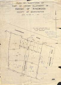 Ringwood and District Historical Society
Map - Plan of Subdivision, Part of Crown Allotment 39, Parish of Ringwood, County of Mornington - (Undated - circa 1930s)
Copy of land title map on light cardboard backing showing layout and size of 11 allotments in Canterbury Road and Culverlands Road, Heathmont, Victoria. Hand-written sales notations on map and backing include names and telephone numbers - Mr Robinson MJ2411, Mr Smith MX5425, Abicare WY1848. Later notation 12/12/67 - A. Robertson. Rubber stamp imprint in top left corner - D.H. Oliver, Civil Engineer & Licensed Surveyor, Bellevue Street Lilydale, Phone Lilydale 91. -
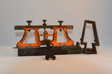 Kiewa Valley Historical Society
Sharpener Saw Raker/Jointer, early 1900s
This raker/jointer/guage set is a sharpening tool for cross cut logging saws. The logging saws used in the early 1900's for the clearing of forests required constant sharpening of their "cutting teeth". The logging of forested areas during these times was very much a "hands on" method of either one or two men by the use of saw or hand axe. Chain saws, chain and ball(clearing) and bulldozing methods came in the mid 1900's.This particular saw sharpening method was used by surveyors laying down boundaries for the S.E.C. Victoria Hydro Electricity Scheme (1920's). This item was given to a local Kiewa Valley lad who accompanied the initial surveyors. The lad was responsible for the tendering and feeding of the surveyors "pack horses". Surveys during this period and in the dense mountainous terrain of the Victorian Alps was both exhausting and hazardous. Overnight accommodation at various log cabins was not always possible and swag/tent alternative was the "fall back" This raker/jointer saw sharpener was made in the USA (DISSTON) from cast and flat iron. The main body has been painted in orange. It has three adjustment screws on the top horizontal bar and one bolt on(adjusting) leveling platform on the bottom. The small size and weight of this saw sharpener was ideal for the travelling/mobile logger or surveyor(as in this case). The main frame resembles two towers connected by two horizontal bars and the top of the towers has a horizontal bar with adjustment screws. See KVHS 0090 (B) for setting stake wedge adjusting the rake and cutting angle and KVHS 0090 (C) for a small spanner (for adjustments).On one inner supports is stamped "DISSTON" and on the other "U.S.A."hand tool, saw, sharpening method, tree felling.