Showing 10017 items matching "the dandenongs"
-
 University of Melbourne, Burnley Campus Archives
Document, Buildings - General, 1983-1988
archive, victorian college of agriculture and horticulture burnley, conservation trust, buildings -
 Melbourne Tram Museum
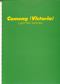
Document - Report, Commonwealth Engineering - Comeng, "Comeng (Victoria) Light Rail Vehicles", c1987
Report - 14 colour A4 sheets + two card covers bound with white comb binding titled "Comeng (Victoria) Light Rail Vehicles", detailing the trams or light rail vehicles built for Melbourne. Details the company, its capability, plant in Dandenong, Design using CAD systems, tram production photographs, details of the B class, A and Z3 along with description and engineering details including drawings of each unit.trams, tramways, comeng, commonwealth engineering, b class, a class, z3 class, tram bodies, bogies, light rail, tramcars -
Glen Eira Historical Society
Map - Caulfield Fire Station, No 26, Tree Reserve, Dandenong Road
A one page photocopy of an undated, unattributed, hand drawn map (200mm x 290mm) of the location on Tree Reserve, Dandenong Road, of the Caulfield Fire station, No 26. The map includes handwritten notes showing various nearby property owners. The file also includes a photocopy of a one page, undated and unattributed printout of the site address and site lease date.caulfield east, caulfield fire station, dandenong road, derby road, racecourse road, tree reserve, shire of caulfield, federal bank, st james building society, delves murchison, fire stations -
Glen Eira Historical Society
Article - Toyne, Gilbert
This file contains two documents. Typewritten letter from Peter Cuffley providing background on Gilbert Toyne, manufacturer of the QUICK-DRY Rotary Clothes Hoist in Dandenong Road. Envelope attached. Computer print-out on HUNG OUT TO DRY the book, written by Peter Cuffley. Interview with him on ABC Ballarat Radio. Small black and white photo of hoist.toyne gilbert, quick dry rotary clothes hoist, toyne trading co., farrier, vernegie, ellimatta road, morton road, caulfield racecourse -
 Dandenong/Cranbourne RSL Sub Branch
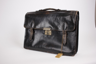
Equipment - Brief Case
This briefcase belonged to Tom Aldrick, SERN VX91434. Tom was born in WARRAGUL VIC. He enlistmented in ROYAL PARK VIC. His next of kin was - ALDRICK J. The briefcase was captured from a Japanese soldier by HQ Company 2/14th Infantry Battalion, as shown by the Japanese inscriptions. The case had some documents inside. It was donated to Dandenong RSL in 1983.Black leather brief case with carry handle on top. It has one central metal slide locking facility. Has two buckles on either side of central lock to secure briefcase. There are a couple of Japanese words inscribed with texta on the inside of the brief case. There is also the name "T & R.E. Aldrich Bayles" written with biro the inside of the briefcase. -
 Melbourne Tram Museum
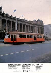
Pamphlet - Commonwealth Engineering, Commonwealth Engineering - Comeng, 1975
Photograph of then new Melbourne tram Z1 outside Parliament House, Melbourne turning from Spring St, soon after the launch of the tram on 30/4/1975. Provides information on Commonwealth Engineering, (Comeng), the company who made the bodies in Dandenong. This location continues to provide trams for Melbourne, though the manufacturer has changed names a number of times.Yields information about the manufacturer of the Z class trams and the appearance of the first tram of the class when new.Pamphlet - Commonwealth Engineering - tramcar Z1 - company details and a photo or Tramcar Z1 outside Parliament House. Printed on gloss paper.trams, tramways, new trams, comeng, z class, z1, spring st, parliament house, commonwealth engineering -
 Ringwood and District Historical Society
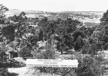
Photograph, Two images of view from Pinemont Estate, Loughnans Hill, looking east, c1930
Black and white photograph of view. Trees and bushes in foreground, orchards and mountains towards background. (2 copies)Typed on photograph, "Pinemont Estate, Ringwood. View Dandenong Ranges, from estate". Typed below photograph, "View from Loughnans Hill, looking east, c1930. Club Hotel can just be seen top right corner". -
 Ringwood and District Historical Society
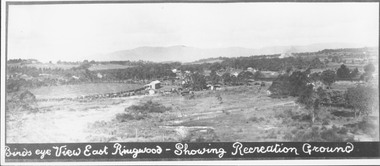
Photograph, Birds eye view East Ringwood - Showing Recreation Ground. Mt. Dandenong Rd. on right. Taken from present Civic Centre site. Football final in progress - 1923
Written below photograph, "Birds eye view East Ringwood - Showing Recreation Ground". Typed below photograph, "Mt. Dandenong Rd. on right. Taken from present Civic Centre site. Football final in progress - 1923". -
 Ringwood and District Historical Society
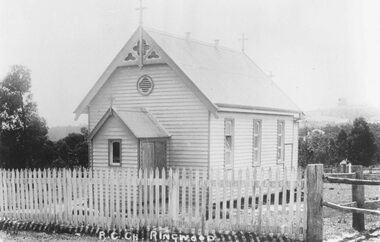
Photograph, Roman Catholic Church, Ringwood 1915 (Built 1893)
Black and white photograph of small wooden church.Typed below photograph, "Roman Catholic Church - Whitehorse Rd. opposite Mt. Dandenong Rd. intersection - 1915" Written on back of another copy: Built 1893 at (one stage) in grounds of R.C. School. Photographer Brian Pump. -
 Mt Dandenong & District Historical Society Inc.
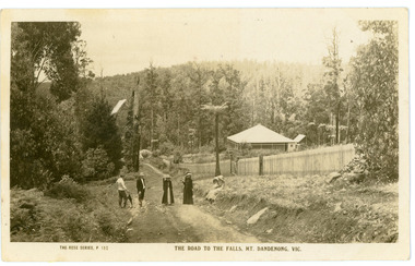
Photograph, The Road To The Falls Mt. Dandenong. Vic, early 1900s
Postcard showing two men and two women standing on Falls Road and two girls sitting on the grassy bank. This section of Falls Road would be below the current Tourist Road. A long fence has been built on the LHS and a house with a verandah is clearly seen. Early 1900s. The postcard appears to have been sent to Jim Woolrich from Auntie Florrie.On front of postcard: THE ROSE SERIES #152 THE ROAD TO THE FALLS, MT. DANDENONG. VIC. On back of postcard: Mr J Woolrich 58 Mountfield St Brunswick Wishing you many happy returns of the day from Auntie Florrie. falls road, olinda falls, mt dandenong, rose series -
Glen Eira Historical Society
Ephemera - Restaurants-Glen Eira
This file contains one item: 1/A pamphlet for Mandarin Court Restaurant, 557 Centre Road Bentleigh, and its sister restaurant in Dandenong, both owned by Michael and David Chew. The pamphlet contains the history of Mandarin Court Restaurants, maps of its locations, opening hours, and its takeaway menu. A special offer is included stamped as valid until 15/08/1987.mandarin court restaurant, chew michael, chew david, bentleigh coppins reception, centre road, bentleigh, restaurants -
 Mt Dandenong & District Historical Society Inc.
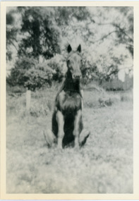
Photograph, Logan's Trick Horse
John Lundy-Clarke grew up in the Kalorama/Mt Dandenong area and later in life (1972-74) began to write a comprehensive history of the area working from an original settlement map in an effort to cover all areas. This photograph shows the 'trick horse' belonging to Robert Logan. Robert Logan settled on Lot 28 in 1896 and worked it until his death in 1936.Black and white photograph on a horse sitting in grass. Handwritten inscription on reverse by John Lundy-Clarke.1920 Logan’s trick horse on LOT 28 SECTION 1robert logan, logan, horse, kalorama, john lundy-clarke -
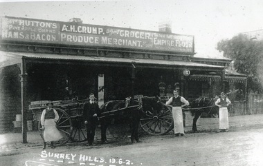 Surrey Hills Historical Society Collection
Photograph, Alfred Henry Crump's grocery and produce store in Canterbury Road, Surrey Hills, 1913, 1913
This building was adjacent to Surrey Lodge, on the corner of Canterbury and Union Roads. The store was established by George Sim in 1885 and in 1889 he set up the 1st Surrey Hills Post Office here. The business was bought by Alfred Claude Geer in 1909; the Camberwell Rate books show that from 1913 Geer remained owner but the business was occupied by Alfred Henry Crump; confirmed by electoral rolls for 1913-1918. Prior to moving to Surrey Hills, Alfred was a grocer in Dandenong. Otto Kuhn was Alfred Crump's store manager and may have taken this photo. Alfred married Hazel May Ordish in 1913 in Dandenong. The marriage notice in the Argus on 5 July indicates that the couple resided at 'Hazeldene' in Leopold Crescent. Moran and Cato had already established a business across Union Road from McNeill's Hotel and in time this business and one other grocery store opposite closed as a result.Black and white photo of A H Crump's grocery and produce store in Canterbury Road, Surrey Hills in 1913. There are 4 men and 2 horse-drawn carts in front of a timber single-storey building with a verandah with a corrugated-iron roof. At least one of the carts has "A H CRUMP" painted on the side. Three of the men are wearing long white aprons; the other, AH Crump, is in a suit. Advertising signs on the hoardings are for Huttons hams and bacon and Empire flour. Cadbury's cocoa is advertised on the shop window. The hoarding above the verandah also indicates that the business was established in 1884. There is a block-fronted single storey house with a picket fence adjacent to the shop, to the east along Canterbury Road."SURREY HILLS.13.6.2" diagonally across the bottom LH side of the photo.post offices, grocers, shops, businesses, horse drawn vehicles, alfred henry crump, alfred crump, alfred claude geer, alfred geer, otto kuhn, george sim, hazel may ordish, hazel may crump -
 Ringwood and District Historical Society
Photographs, Rebboch, Myil, Restaurants and cafes in Ringwood/Ringwood East photographed by Myil Rebboch - 1999-2000, 1999 - 2000
Bundle of 21 photographs in Agfa folder. Restaurants and cafes in Ringwood/Ringwood East 1999 - 2000. Taken by Myil Rebboch. Smorgy's - corner of Oban Road and Maroondah Highway (3211_Smorgy's_001) Red Rooster - corner of Beaufort Road and Maroondah Highway (3211_Red Rooster_002) Kublai Mongolian - corner of Beaufort Road and Maroondah Highway (3211_Kublai_003) Nikos Greek Tavern - Mt Dandenong Road opposite Carcoola Road (3211_Nikos Greek Tavern_004) Turtle Den - Railway Avenue Ringwood East (3211_Turtle Den_005) Maroondah Sporting Club - Mt Dandenong Road (3211_Maroondah Sporting Club_006) Hungry Jack's - corner of Mt Dandenong Road and Maroondah Highway (3211_Hungry Jack's_007) Daisey's Hotel - Mt Dandenong Road (3211_Daisey's Hotel_008) Lone Star - Maroondah Highway (3211_Lone Star_009) Canton - Murray Place (3211_Canton_010) Cafe Thirty-Five - Ringwood Street (3211_Cafe Thirty-Five_011) Cafe Ringwood Market (3211_Cafe Ringwood Market_012) Phoolwari - Eastland (3211_Phoolwari_013) Jamaica Blue - Eastland (3211_Jamaica Blue_014) Gourmet - Eastland (3211_Gourmet_015) Muffin Break - Eastland (3211_Muffin Break_016) Food Terrace - Eastland (3211_Food Terrace_017) Croissant - Eastland (3211_Croissant_018) Emerald Hill - Eastland (3211_Emerald Hill_019) Fasta Pasta - Eastland (3211_Fasta Pasta_020) Eating In - Eastland (3211_Eating In_021) -
 Melbourne Tram Museum
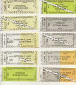
Ephemera - Ticket/s, Public Transport Corporation (PTC), Set of 21 The Met Neighbourhood tickets, 1989
Set of 21 The Met Neighbourhood tickets - May to August 1989. Conditions of use printed on rear. Printed on white paper. 1. Dandenong Neighbourhood - 183516 2. Ditto concession - 208212 3. Dandenong plus one Neighbourhood - 019512 4. Ditto concession - 018513 5. Ringwood Neighbourhood - 144534 6. Ditto concession - 168995 7. Werribee Neighbourhood - 018612 8. Ditto concession - 018959 9. Werribee plus inner Neighbourhood - 014015 10. Ditto concession - 008168 11. Ringwood plus one Neighbourhood - 024729 12. Ditto concession - 0198882 13. Inner Neighbourhood - B089291 14. Ditto concession - A088033 15. Inner plus one Neighbourhood - 359210 16. Ditto concession - 224012 17. Broadmeadows Neighbourhood - 044541 18. Ditto concession - 038635 19. Broadmeadows Plus Inner Neighbourhood - 034587 20. Ditto concession - 024933 21. Greensborough Plus One Neighbourhood concession - 003016trams, tramways, tickets, the met, ptc, neighbourhood tickets -
 City of Moorabbin Historical Society (Operating the Box Cottage Museum)
Photograph - Plateway (Wheelway) Steel, circa 1885
By the later 1800s the dirt roads in the then out-lying areas of the City of Moorabbin became dangerous, and almost impassable due to huge potholes and muddy swampy areas. The heavily laden market gardener’s carts regularly broke axles and wheels, and horses foundered on their way to the Melbourne markets. Even worse, the heavier “iron maidens”, carrying their malodorous loads of sewage from Melbourne’s inner suburbs for dumping in the outlying areas of the City of Moorabbin, also got bogged in the mire. It was decided that a practical solution to this problem was to install a metal plateway on the side of the problematic roads. In about 1887 the Moorabbin Shire Centre Road, in the Brighton East area, two parallel metal rails were installed so that the wheels of carts could run along smoothly, the horse travelled in the filled, middle area between the rails. Point Nepean Road plateway was removed in 1930 and Centre Dandenong Road plateway was removed in 1934-35. The worn plateway along Centre Road, East Brighton (now known as Bentleigh), was gradually taken up in several pieces, commencing in the the1920s, when its condition deteriorated and it caused a hazard to bikes, pedestrians, motor-cycles and the few early cars. The early steel plateway, constructed by David Munro, and opened on 23rd March 1885 by Thomas Bent, was built along Nepean Highway, between Asling St. and Bay St. The Point Nepean Track was subsequently extended into Moorabbin with branches along Centre, Cumins, South, Wickham, and Keys Roads, the total length was 13 miles. In 1908-1909 plates were laid along Centre Dandenong Road to Ross Street Bentleigh This innovative solution proved successful and was used until gradually the main roads were upgraded, and motorised vehicles started to appear. Two parallel metal rails were installed in the right hand side of a few main roads in the Shire of Moorabbin so that the wheels of heavily-loaded market gardener's carts on their way to markets in Melbourne could run along smoothly. The horse pulling the carts travelled in the filled, middle area between the rails. The Steel Plateway was constructed by David Munro, and opened on 23rd March 1885 by Thomas Bent. The wheelway first only ran along Nepean Highway, but it soon extended from Centre Dandenong Road, along Nepean road to its junction with Chapel Street, St Kilda. Later branch lines were built along Centre Road, Bentleigh as far as Warrigal Road and, according to early photographs, along Wickham Road Moorabbin as well. This innovative solution proved successful and was used until gradually the main roads were upgraded, and motorised vehicles started to appear. There was a problem with the wheelway : there was only a single set of rails and this was established on the right-hand side of the Nepean Road, travelling towards the city. Traffic FROM the city travelled on the correct or left-hand side of the road. The exception to this rule was the malodorous iron-clads, heavily riveted iron carts, generally travelling in convoy, carrying several tons of human effluent out of Melbourne to be trenched-in in the sandy soil of the Moorabbin district. Moorabbin City Council donated and installed a small section of Plateway at Box Cottage Museum in 1984melbourne, brighton, moorabbin, roads, plateway, wheelway, transport, st kilda, bent thomas, munro david, market gardens, steelway, carts horse-drawn, iron maidens, point nepean track -
 Melbourne Legacy
Document - Speech, Address to Dandenong Probus Club 2014, 2014
A speech by Legatee Bill Rogers describing the work of Legacy to the Dandenong Probus Club on 6th October 2014. It provides a snapshot of statistics and work done by Legacy at the time. It mentions 49 clubs in Australia, helping 90,000 widows and around 1,020 dependants. Document was from a folder of documents donated to the archive by Legatee Bill Rogers that related to his time as President (March 2006 - March 2008).A record of Legacy in 2014 and its work at the time.Print out x 6 pages of a speech by Legatee Bill Rogers to a Probus club in 2014.speeches, bill rogers -
Melbourne Tram Museum
Pamphlet, Minister for Public Transport, "Melbourne's new G class tram", 8/11/2024
Pamphlet titled "Melbourne's new G class tram" - an update on the design and construction, including an aerial view of the new Maidstone depot following a Ministerial visit to the Alstom plant on 8/11/2024 - "Minister for Public and Active Transport Gabrielle Williams today visited Alstom’s factory in Dandenong to announce the start of major works on the Next Generation Trams Project." See htd7796i2 for the Press Release.Yields information about the new G class trams and the new Maidstone depot.Pamphlet - 4 sheets when printedtramcars, new trams, g class, alstom, press release -
 Ringwood and District Historical Society
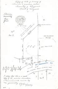
Document - Copy of Lands Department Field Notes - Survey of Extension to Recreation Reserve, Township of Ringwood, Victoria, Field Notes 1907/436 - Part of O.P. R72D Surveyed 6.8.1907
Foolscap size photocopy of survey map with handwritten notations. References include New Lilydale Road 3 chains wide (Mount Dandenong Road), Silurian, undulating, poor grass, Corner cut off to allow for road in future subdivision, Old recreation reserve, (circled area) oval now in use, A. Gisler, I certify that this is a correct copy of the recorded observations & measurements made by me personally (signed) R.J. Gray 6/8/07. -
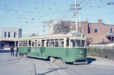 Melbourne Tram Museum
Photograph - Five color slides - tram PCC 980, 9-8-1970
Set of four colour slides taken during the Monash Railway club tour on 9-8-1970 using PCC 980 from Malvern Tram Depot. The route number and destinations are for show only. Photographs by Warren Doubleday.Yields information on Monash Railway club tour, the trams used and the locations.Set of five Anscochrome colour slides, of Melbourne tram PCC 980 on a Monash Railway Club tour - 9-8-1970 .1 - PCC 980 on the depot access tracks for Malvern Tram Depot in Coldblo Road .2 - With the Malvern Tram Depot in the view .3 - In Dandenong Road at Hawthorn Road .4 - Crossing Hawthorn Road - has a tram shelter in the view. .5 - About to use the then new Nolan St (now Southbank Blvd) crossover.Has photographers slide numbers on each slide.monash railway club, tram 980, malvern depot, hawthorn road, dandenong road, nolan st, tramways, trams, pcc class -
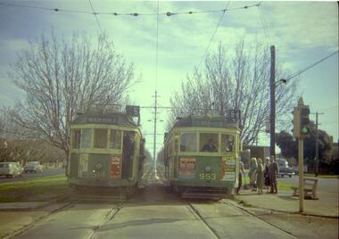 Melbourne Tram Museum
Negative, Travis Jeffrey, 10/06/1962 12:00:00 AM
Colour negative of trams 514 and 953 in Dandenong Road. Tram 514 has destination Malvern - Burke Rd and Route No 5. Photo shows tram on the left track (city-bound), although facing towards its destination (Malvern). Driver standing in door of cab and conductor standing in doorway to tram. Tram 953 has destination East Brighton via Caulfield and Route No 64. Sign on front states: "Connect with Malvern-Burke Rd tram".Paper folder that contained the negative had "NR75B" and date written as 10 Jun 62 in red ink.trams, tramways, w2 class, route 5, route 64, dandenong rd, wattle tree rd, malvern burke rd, tram 514, tram 953 -
 Whitehorse Historical Society Inc.
Photograph, Australia Post delivering Post Box, 1/09/2000 12:00:00 AM
This item was originally acquired by Harold Bakes, together with a Fire Hydrant Stand And a petrol pump , from the P.M.G. depot in Hawthorn in the 1970s . It was stored in the City of Nunawading Council yard in Station Street, Nunawading, and later loaned to the Australia Post Mail Exchange in Rooks Road, Nunawading. On the closure of the Mail Exchange, it was transferred to the Australia Post Museum in Dandenong. After proving ownership it was returned to back to the Society's Museum.Coloured photo of an Australia Post delivering restored Post Box to the Society's Implement Shedaustralia post, bakes, harold arthur -
Disability Sport & Recreation Victoria
DVD, 2012 National Wheelchair Basketball League Finals, 20/06/2012
The DVD features footage from two matches from the 2012 season of the National Wheelchair Basketball League. The DVD features extended highlights from the game for 3rd/4th place, between the Sydney University Wheelkings and Dandenong Rangers. Following this game is the full recording of the championship game played between Perth Wheelcats and Wollongong Rollerhawks. These games were played in Shellharbour on the New South Wales south coast.DVD inside case2012 National Wheelchair Basketball League Finalsdjuro sen, national wheelchair basketball league, wheelchair basketball, sydney university wheelkings, perth wheelcats, wollongong rollerhawks, dandenong rangers, dylan alcott -
 Ringwood and District Historical Society
Map - Public Land Sale by Thomas Ham, 2000 Acres for Sale - Crown Sections 20, 23, 24 - Ringwood, Victoria - 1855
Two 1850s surveyor's maps on cardboard backing showing area from Melbourne extending East beyond Bulleen and Nunawading. Detailed description of lots for sale and navigational directions to the property from Richmond by Thomas Ham, Victorian public servant, map maker, publisher, lithographer and original Ringwood land owner. Inset map enlarging area between Yarra River and Dandenong Creek, with southern boundary of allotments later forming part of Oban Road, North Ringwood.TRANSCRIPT: "This really valuable Property is now offered to the public for sale, in lots to suit purchasers at the Iow rate of £1 per Acre for 80 acres and upwards, and £1.10s per Acre for any smaller portion. Terms of payment Half Cash, Balance in 6 and 12 months, bearing 8 per cent interest. The Estate is well wooded with Gum, Cherry Tree and Stringy Bark, with Wattle in the valleys of the several creeks. Every lot is Staked and Trenched at the corners marked on the Plan thus - The Surveyor has carefully sub-divided the Property, in order to give every Farm a Creek for Water, Valley for Cultivation, and Hills for House and Grass Paddock. The ROADS have been very carefully laid out so as to give a firm, well drained, and nearly level road to each Homestead. Intending purchasers can readily find the property by the following directions, viz: Start from Richmond Bridge, at Hawthorne, then take the left-hand road to KEW. When at the "Woodman Inn", take the Cotham Road to the right, bearing due east, keep this Road, passing Trainor's "White Horse" Inn, and before you leave the fences, you will see calico bills (see margin) nailed to the Trees on the bush track leading to the Upper Yarra country, follow the Bills till you come to the SOUTH boundary line of the Property, which bears East and West (see Plan) where you will see Bills nailed up "THIS PROPERTY FOR SALE, etc." The Bills from Town lead direct to where Mr. Jull is erecting his Store, and arrangements have been made with him to show the lots to intending purchasers free of charge. At the respective corners of the lots the Bills are nailed up double, with numbers to denote the lot, and that the corner stake is adjacent. Any parties wishing to proceed to the property by way of BULLEEN will find Bills nailed on the Trees, commencing at the NEW INN, at "Wilson's Slip Rail." Keep this Track till you come to the Log Bridge, over the Deep Creek at Bloxhome's Paddock; go through the land now being cleared; keep the track over the hill till you come to an Iron House, you will then be on the property, which Iies to the North and East as per Plan. Follow the Bills till you come to Mr. Jull's Store, etc. etc. Further particulars can be had from the Agent for the Property. THOMAS HAM. " -
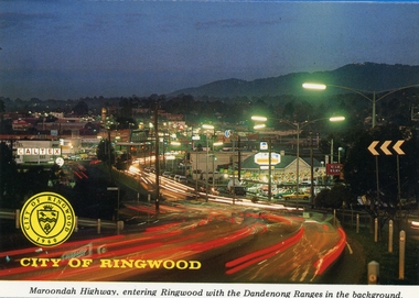 Ringwood and District Historical Society
Postcards, Colorscans (Publishing) Pty Ltd, Various postcards of Ringwood in the 1970s, c. 1968
Postcards - pack of 6: 'Ringwood Victoria - tear off postcard folder - 6 views' (two identical folders); 1. Maroondah Highway, entering Ringwood with the Dandenong Ranges in the background (3303_001.jpg); 2. Aerial View of the City of Ringwood (3303_002.jpg); 3. Eastland Regional Shopping Centre at dusk (3303_003.jpg); 4. The Ringwood Memorial Clock Tower (3303_004.jpg); 5. The Civic Centre (3303_005.jpg); 6. The Ringwood Lake (3303_006.jpg) -
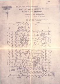
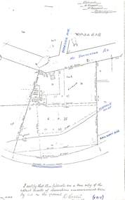 Ringwood and District Historical Society
Document - Copy of Lands Department Field Notes - Parish of Ringwood, Victoria, Field Notes - OP34838 - surveyed in 1919 by D. Barker
5615b Foolscap size photocopy of survey map with handwritten notations. References include Braeside Avenue, Mount Dandenong Road, Rosedale Court, Railway Avenue, cyclone fence, Sec A, WB house, old tennis court netted, stable, old shed, tank stand, orchard, Township Boundary, netting fence, Railway fence, Ringwood to Lilydale Railway, I certify that these fieldnotes are a true copy of the actual results of observations & measurements taken by me on the ground (signed) D. Barker (1919). -
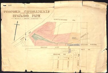 Ringwood and District Historical Society
Map, Proposed Improvements to Ringwood Park (Ringwood Lake) dated 14 January 1927
Proposed Improvements to Ringwood Park (Ringwood Lake) dated 14 January 1927, signed Cr McCaskill. Main Road is Whitehorse Road (Maroondah Highway), and Mt Dandenong Road is incorrectly labelled Whitehorse Road. The map shows Rosedale Crescent and Railway Parade, both of which exist in 2024. On the bottom of the map, south of the railway line, showing proposed streets - Graham Road, Anderson Street and Adams Street - in preparation for the sale of the Theo Anderson property. That area is now Bedford Park. -
Whitehorse Historical Society Inc.
Document, Fruitgrowing in early Vermont
Handwritten information about fruit growing in Vermont from about 1880 to 1945. the area bounded by Boronia Road, the Dandenong Creek and Morack Road was a grant by Queen Victoria to an old soldier named Moore.Handwritten information about fruit growing in Vermont from about 1880 to 1945. the area bounded by Boronia Road, the Dandenong Creek and Morack Road was a grant by Queen Victoria to an old soldier named Moore. This area was subdivided about 1880. A few fruit trees planted. Later Williams Pears and Jonathan Apples were found to be best to grow. The peak of growing fruit was 1930 - 39 and steadily declined after this due to labour shortages and lack of markets during 1939 - 1945.Handwritten information about fruit growing in Vermont from about 1880 to 1945. the area bounded by Boronia Road, the Dandenong Creek and Morack Road was a grant by Queen Victoria to an old soldier named Moore. orchards, boronia road, vermont, dandenong creek, moore, isaac, morack road, vermont south -
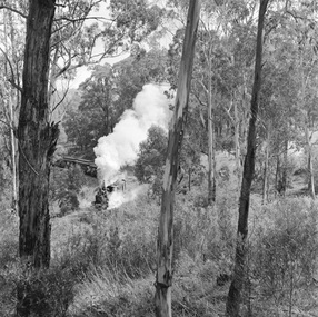 Southern Sherbrooke Historical Society Inc.
Photograph - Puffing Billy train
Two black and white photos dated 1962 from the National Archives of Australia, showing the Puffing Billy train in the Dandenongs. - Ground is steep and heavily treed and may be the stretch of line between Menzies Creek and Clematis Station. - Large trees line the track. There is a driveway below the line with large puddles. A car can be seen crossing the line behind the train. A lightly treed hill is visible in the background. This may be the crossing at the Clematis end of Menzies Rd with Tivoli Farm in the distance. -
 Ringwood and District Historical Society
Document - Folder, Land Sale, Parkhaven Estate, Heathmont, Victoria - 1968
Manilla folder containing 2-page foolscap size typewritten summary of Parkhaven Estate Heathmont multiple release allotment prices and two maps headed Plan of Subdivision - Part of Crown Portion 13, Parish of Ringwood. Subdivision includes Cuthbert Street, Waterloo Street, Sunset Drive, Markhill Place, Parkhaven Drive, Bayley Close and Blenheim Street. Agents - Consolidated Home Industries Limited, Lower Dandenong Road, Braeside, Vic., Phone 91-9791. Rep - Bruce Grant.Accompanying handwritten sales note researched in 2024 by Richard Carter - Carter Real Estate - "Generally $2500 to $4000 per lot".