Showing 558 items matching "victoria: the garden state"
-
 Falls Creek Historical Society
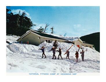
Postcard - National Fitness Camp at Howman's Gap
These photographs were taken in and around Falls Creek by Samuel Keith Pearce and printed for him as a foldout postcard by NuColor Vue. The postcards state they were printed for S. K. Pearce Pty. Ltd of Tawonga and Mount Beauty. Samuel Keith Pearce was born on 24 June 1917 in Armadale, Victoria. By the late 1940s he owned the Mt Beauty Supermarket, Newsagency, Drapery and Hardware store at Mount Beauty and also a store at Tawonga in partnership with his brother Gordon Cathew Pearce. For some time, they operated as Pearce Brothers. In the early 1960s Keith also opened a mini mart In Falls Creek. As well as being a keen photographer and an astute businessman, Keith Pearce was a well-known identity in the Kiewa Valley, making many contributions to the development of the area over a long period. This included serving as a member of the Bright Shire Council for many years. He worked hard to promote the interests of the Upper Kiewa Valley. As a sign of recognition and appreciation for his contribution to the community, the park opposite the grocery store in Mount Beauty was named the SK Pearce Gardens in his honour. Samuel Keith Pearce died on 7 July 1994 in Mount Beauty, VictoriaThis collection of postcards and image is significant because they were commissioned by a highly successful business in Falls Creek, Victoria.A high definition photo of the skiers walking in front of the National Fitness Camp at Howmans Gap. The Camp was run by the Victorian State National Fitness Council. Initially the camp was leased from the State Electricity Commission (SEC). It had a capacity of 110 participants and offered both summer and winter activities.falls creek resort, national fitness camp howmans gap -
 Falls Creek Historical Society
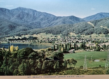
Postcard - Mt. Beauty, Victoria
These photographs were taken in and around Mount Beauty and the Kiewa Valley by Samuel Keith Pearce and printed for him as a foldout postcard by NuColor Vue. The postcards state they were printed for S. K. Pearce Pty. Ltd of Tawonga and Mount Beauty. Samuel Keith Pearce was born on 24 June 1917 in Armadale, Victoria. By the late 1940s he owned the Mt Beauty Supermarket, Newsagency, Drapery and Hardware store at Mount Beauty and also a store at Tawonga in partnership with his brother Gordon Cathew Pearce. For some time, they operated as Pearce Brothers. In the early 1960s Keith also opened a mini mart In Falls Creek. As well as being a keen photographer and an astute businessman, Keith Pearce was a well-known identity in the Kiewa Valley, making many contributions to the development of the area over a long period. This included serving as a member of the Bright Shire Council for many years. He worked hard to promote the interests of the Upper Kiewa Valley. As a sign of recognition and appreciation for his contribution to the community, the park opposite the grocery store in Mount Beauty was named the SK Pearce Gardens in his honour. Samuel Keith Pearce died on 7 July 1994 in Mount Beauty, Victoria Mt. Beauty at the head of the Kiewa Valley was established by the State Electricity Commission during the development of the Kiewa Hydroelectric Scheme. It forms the gateway to the Bogong High Plains, and is a popular centre for holiday makers in the north-east providing accommodation and access to excellent fishing grounds and, in winter, to the popular ski slopes of nearby Falls Creek.This collection of postcards and images is significant because they were commissioned by a highly successful businessman in Falls Creek, Victoria.A colour image of Mt. Beauty Township and Mt. Bogong from Power Line Lookout.mt. beauty, s. k. pearce -
 Falls Creek Historical Society
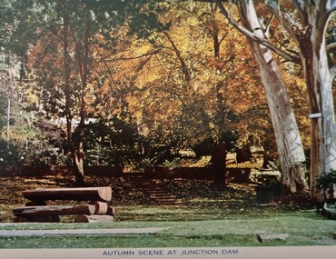
Postcard - Junction Dam, Kiewa Hydroelectric Scheme
These photographs were taken in and around Mount Beauty and the Kiewa Valley by Samuel Keith Pearce and printed for him as a foldout postcard by NuColor Vue. The postcards state they were printed for S. K. Pearce Pty. Ltd of Tawonga and Mount Beauty. Samuel Keith Pearce was born on 24 June 1917 in Armadale, Victoria. By the late 1940s he owned the Mt Beauty Supermarket, Newsagency, Drapery and Hardware store at Mount Beauty and also a store at Tawonga in partnership with his brother Gordon Cathew Pearce. For some time, they operated as Pearce Brothers. In the early 1960s Keith also opened a mini mart In Falls Creek. As well as being a keen photographer and an astute businessman, Keith Pearce was a well-known identity in the Kiewa Valley, making many contributions to the development of the area over a long period. This included serving as a member of the Bright Shire Council for many years. He worked hard to promote the interests of the Upper Kiewa Valley. As a sign of recognition and appreciation for his contribution to the community, the park opposite the grocery store in Mount Beauty was named the SK Pearce Gardens in his honour. Samuel Keith Pearce died on 7 July 1994 in Mount Beauty, Victoria Junction Dam, also known as Lake Guy, is situated 16 kms from Mt Beauty, along the Bogong High Plains Road. It was built by the State Electricity Commission of Victoria as part of the Kiewa Hydro Electric Scheme. This collection of postcards and images is significant because they were commissioned by a highly successful businessman in Falls Creek, Victoria.A colour image of Junction Dam in the Upper Kiewa area, showing a bench and autumn trees.mt. beauty, junction dam, lake guy, kiewa hydroelectric scheme -
 Falls Creek Historical Society
Postcard - Mount Beauty Township
These photographs were taken in and around Mount Beauty and the Kiewa Valley by Samuel Keith Pearce and printed for him as a foldout postcard by NuColor Vue. The postcards state they were printed for S. K. Pearce Pty. Ltd of Tawonga and Mount Beauty. Samuel Keith Pearce was born on 24 June 1917 in Armadale, Victoria. By the late 1940s he owned the Mt Beauty Supermarket, Newsagency, Drapery and Hardware store at Mount Beauty and also a store at Tawonga in partnership with his brother Gordon Cathew Pearce. For some time, they operated as Pearce Brothers. In the early 1960s Keith also opened a mini mart In Falls Creek. As well as being a keen photographer and an astute businessman, Keith Pearce was a well-known identity in the Kiewa Valley, making many contributions to the development of the area over a long period. This included serving as a member of the Bright Shire Council for many years. He worked hard to promote the interests of the Upper Kiewa Valley. As a sign of recognition and appreciation for his contribution to the community, the park opposite the grocery store in Mount Beauty was named the SK Pearce Gardens in his honour. Samuel Keith Pearce died on 7 July 1994 in Mount Beauty, Victoria Mount Beauty was originally established by the State Electricity Commission of Victoria to house construction workers from the Kiewa Hydroelectric Scheme in 1949,[2] passing to the control of the local shire council in 1967 after construction was completed. The town is a launching point for trips to the Falls Creek ski resort, and to the Bogong High Plains. This collection of postcards and images is significant because they were commissioned by a highly successful businessman in Falls Creek, Victoria.A colour image of the township of Mount Beauty in the Upper Kiewa Valley.mt. beauty, kiewa hydroelectric scheme, falls creek, bogong high plains -
 Falls Creek Historical Society
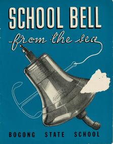
Booklet - School Bell from the sea - Bogong State School
This booklet tells the story of the bell from the "S. S. Santhia" and how it came to Bogong State School, Victoria. "Santhia" belonged to the British India Line. On 6th November 1943 she was in service as a troopship when she caught fire and capsized at No. 3 Garden Reach Jetty, Calcutta. Due to the additional weight of water pumped into her to extinguish the fire, "Santhia" heeled over and remained in the mud of the River Hooghly until a successful salvage was completed in January 1946. The salvage operation was carried out by Captain J. P. Williams of Melbourne and his team of Australian divers nine and a half months after the commencement of operations. "Santhia" was the sixty seventh ship salvaged by Captain Williams. "Santhia's" Bell was presented by Captain Williams to Mr G.G. Jobbins, Chairman of Commissioners for installation at Bogong State School. The ceremony of presenting the bell took place on 21st February 1947. The bell bears the following inscription:- "Presented to G.G.Jobbins, Esq., Chairman, State Electricity Commission, by Captain J.P. Williams for Bogong School, on December 6th, 1946. This bell was recovered from the wreck of the "S.S.Santhia" sunk in the Hooghly River, Calcutta, and raised by an Australian salvage party."This booklet is significant because it documents an unusual event linking Bogong State School to a World War II salvage operation.A booklet consisting of images and text which tells the story of S.S. Santhia, of her sinking while in service as a troopship, of her subsequent salvage and how her bell came to Bogong State School in Victoria's High Country. The booklet consists of 12 pages including the cover. It consists of text and images. Primarily printed in black and white, the booklet uses blue boxes to highlight text including titles and explanation of images. The cover is blue with white text and features an image of the bell of the S. S. Santhia.Inside front cover: THIS BOOKLET is presented by THE STATE ELECTRICITY COMMISSION OF VICTORIA to the children of BOGONG STATE SCHOOLbogong state school, s.s.santhia, santhia bell -
 Parks Victoria - State Coal Mine - Wonthaggi
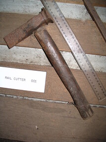
Rail cutter
used on spin from Wonthaggi to East Area. Found 10m N.W of electric shed June 1987Standard type of rail cutter/dog. -
 Parks Victoria - State Coal Mine - Wonthaggi
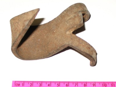
Timber claw, C 1920
Used in State Coal Mine by Bill Tyrell'S' shaped hook with a sharp point on one end and two claws on the other. -
 Parks Victoria - State Coal Mine - Wonthaggi
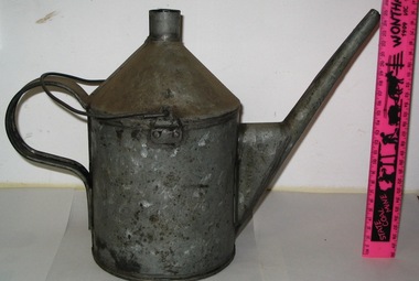
Oil can, C1920's
Used in State Coal Mine by propman to oil cable and rollersApproximately 2 litre tin can with spout, rear fixed handle and top loose handle"W.T.S." on base in red paint -
 Parks Victoria - State Coal Mine - Wonthaggi
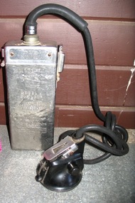
Lamp, Thomas A Edison
Used in S.C.M by an unknown minerStainless steel battery case, black lead to lamp fitting. See (SCM 0938) for printed manual.On front of lamp fitting " EDISON SAFETY LAMP MFD. BY THOMAS A. EDISON. INC. WEST ORANGE. N.J. UNITED STATES OF AMERICA" On top of battery case "EDISON" The side of the top of the battery case has "365" stamped on it showing that it was not the original top. The battery case has "M78". Side of battery has the "Thomas A Edison" seal. Below that reads "MODEL J CAP LAMP Approved Under Lighting Schedule Approval issued to THOMAS A EDISON CAUTION The battery and headpiece housings shall not be unlocked or opened by the lamp user." -
 Parks Victoria - State Coal Mine - Wonthaggi
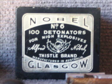
Tin container, Thistle et al, C 1910
Small black tin made by Nobel. Holds 100 detonators. Painted black with white printing.On front side of tin "6 6" On rear side of tin "6 6" On lid of tin "NOBEL No.6 100 detonators for high explosives Alfred Nobel (Picture of thistle flower) THISTLE BRAND Manufactured in Australia GLASGOW" On left hand side and right hand side of tin "Must be handled with great care and kept dry. The composition must not be scratched or pricked with a pin, nail, knife or other hard substance. as any act of this kind may cause explosion." -
 Parks Victoria - State Coal Mine - Wonthaggi
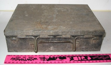
Tin, C 1920's
Used by Fred Oldaker in S.C.M to carry sticks of dynamiteRectangular tin, painted black with hinged lid -
 Parks Victoria - State Coal Mine - Wonthaggi
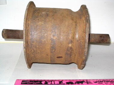
Cable roller, C 1940's
Used in S.C.M Wonthaggi . The roller cable was supported by a frame between the rails, it was on the cable.Heavy duty cable roller -
 Parks Victoria - State Coal Mine - Wonthaggi
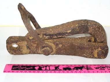
Hook, C 1940's
Used to unload stores at Number 5 Brace stores area. Found near Number 5 Brace August 1985. A wire rope would lift hook from top. A cord through cross piece of hook could be pulled to release the load.Crane hook with catch to keep load held. -
 Parks Victoria - State Coal Mine - Wonthaggi
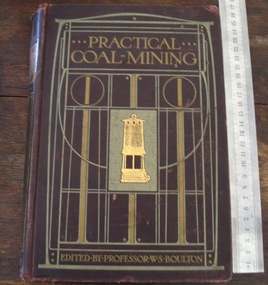
Book, "Practical Coal Mining Vol 1"
A. Part of a volume of six (6) books used for study by G.Hadden. B. It is an introduction to coal mining in G.B."Practical Coal Mining Vol 1" 160 page hard bound red cover with gold lettering.Top, inside cover and top, two pages in "G.Hadden" in blue ink. -
 Parks Victoria - State Coal Mine - Wonthaggi
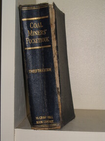
Book, A. E.N.Zern, B. McGraw-Hill book Co Inc, "Coal Miners Pocketbook", 1928
A. Part of the G.Hadden collection B. Details of coal mine methods."Coal Miners Pocketbook" is the book that miners got for some extra tips of digging coal. The book was hard bound with blue covering and gold lettering and 1274 pages.Inside the front cover the name "G.Hadden" was written. -
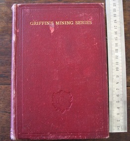
 Parks Victoria - State Coal Mine - Wonthaggi
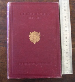
Book, A. Sir Clement Le Neve Foster and J. S. Haldane.B. Charles. Griffin & Co. Ltd, "Investigation of Mine Air"
A. Part of the G. Hadden collection. B. A study of the methods used to measure impurities in mine air."Investigation of Mine Air" is the name of that book that is hard bound with a red cover and gold lettering.Inside the front cover had the name "Miners Department" that was hand written. -
 Parks Victoria - State Coal Mine - Wonthaggi
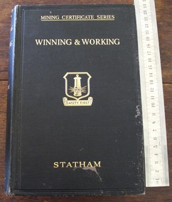
Book, Prof. I.C.F.Stratham, Sir Isaac Pitman & Sons Ltd, "Winning and Working", C 1930
Part of the G. Hadden collection which is a textbook for candidates for the under managers cert."Winning and Working" is the name of this book which is a hard bound book with a black cover with gold lettering and 525 pages.Inside the front cover of the book is the name "G. Hadden Private". -
 Parks Victoria - State Coal Mine - Wonthaggi
Book, 'Tate's Mining', C 1926
A. Part of thet G. Hadden colletion. B. Describes mining arithmitic and mining ventilation theory for mining students.A. Tate's Mining B. Hard Bound, Red Cover, Gold Lettering with 96 pages.Inside front cover: "G. Hadden Broome Cres Wonthaggi" -
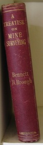 Parks Victoria - State Coal Mine - Wonthaggi
Book, Bennett H. BROUGH, Charles Griffin & Co. Ltd, "A treatise on mine surveying", C 1913
A. Part of the George Hadden collection B.Descibes in detail all aspects of mine surveying"A treatise on mine surveying" Hard Bound, red cover, gold lettering, 372 pages plus a 60 page advertising supplement.Inside front cover: "A.Blackburn Shottou Colliery Co. Durham.", "G.Hadden" -
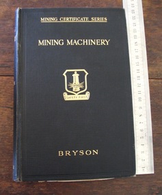 Parks Victoria - State Coal Mine - Wonthaggi
Book, Sir Isaac Pitman & Sons Ltd, Thomas Bryson, "Mining Machinery", 1929
A. Part of the G.Hadden Collection. B. Describes all types of mining machinery"Mining Machinery" Hard Bound, gold lettering, 378 pages.Inside front cover "G.Hadden Private", "10/-" -
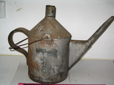 Parks Victoria - State Coal Mine - Wonthaggi
Container, State Coal Mine, C 1940
Used at State Coal Mine to oil equipmentTin oil can with a long spout and top and rear handle -
 Parks Victoria - State Coal Mine - Wonthaggi
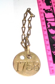
Token, time, State Coal Mine, 1912 - 1968
Used by miners as identification disc.Small brass disc with number stamped on, two holes near top edge, brass chain attached.1758 -
 Parks Victoria - State Coal Mine - Wonthaggi
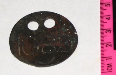
Token, State Coal Mine
Small brass disk with a number stamped on. Two holes near top edge."1089" -
 Parks Victoria - State Coal Mine - Wonthaggi
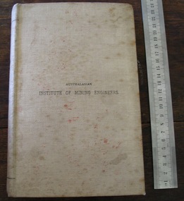
Book, Australasian Institute of Mining Engineers, "Transcriptions of the Australasian Institute of Mining Engineers Vol XIV", 1912
Owned by General Manager J. McLeish.Stained beige cover. Inscription title in black. 327 pages. Titled "Transcriptions of the Australasian Institute of Mining Engineers Vol XIV".On cover " Australasian Institute of Mining Engineers". On spine " Transcriptions Australasian Institute of Mining Engineers Vol XIV". -
 Parks Victoria - State Coal Mine - Wonthaggi
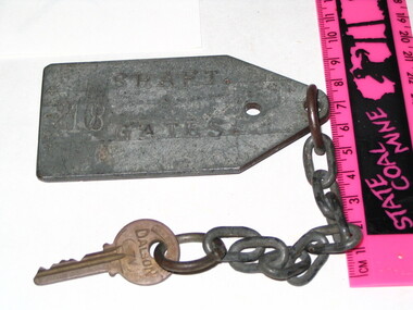
Key, Dalson, Melbourne, Post 1931
Key that opened the gates to No. 20 shaft.Key on metal chain. Chain is attached to a large metal tag.on tag: 20 shaft gates. on key: R 62, Dalson (7V) Melb. Aust. -
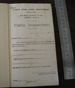 Parks Victoria - State Coal Mine - Wonthaggi
Booklet, Government Printers, "Daily Inspection", C 1960's
Booklet of "Daily Inspection" report sheets, serrated edge. Green cardboard cover, stapled spine covered in grey binding tape. -
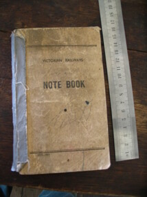 Parks Victoria - State Coal Mine - Wonthaggi
Notebook, "Victorian Railways Notebook", C 1950's
Notebook used to record bags of horse feed at the different mine areas.Dirty brown cardboard cover, grey binding tape on spine. Black text on front cover.Victorian Railways. Notebook 1875-49 -
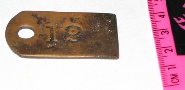 Parks Victoria - State Coal Mine - Wonthaggi
Token
Skip token used by miners to identify which skips they had filled.Small brass rectangle with one curved end. Small hole through left-hand side."19" -
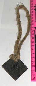
 Parks Victoria - State Coal Mine - WonthaggiSkip token used by miners to identify which skips they had filled.833.1, 833.2: small brass diamond with rope attached through a hole in the top corner."5"
 -
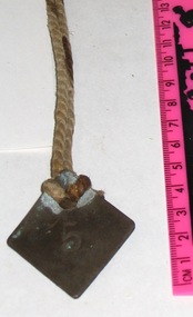
 Parks Victoria - State Coal Mine - Wonthaggi
Token, State Coal Mine
Skip token used by miners to identify which skips they had filled.Small brass diamond with rope attached through a hole in the top corner."18"