Showing 943 items
matching watt
-
 Eltham District Historical Society Inc
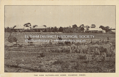
Photograph - Postcard, New Sutherland Home, 28 Drummond Street, Diamond Creek, c.1912
Postcard: Leader (Melbourne, Vic. : 1862 - 1918, 1935), Saturday 15 June 1912, page 48 ________________________________________ NEW SUTHERLAND HOME. OPENED BY THE PREMIER. A new home for destitute and neglected children, erected for the purpose of carrying on the work of the late Miss Sutherland, was formally opened by the Premier (Mr. Watt) at 28 Drummond-street on Thursday. The new building has been erected at a cost of £1600, of which only £300 has been provided by the Government. A similar sum has been raised by private contribution, but there is still a debt of £800 or £900, which the committee hopes to liquidate shortly - to some extent by means of a sale of gifts, which was 'opened in the building, and will be continued this afternoon and evening. The Premier, in performing the opening ceremony, said the home was a monument to the life work of one of the most distinguished social servants this country had known. (Applause.) Although Miss Sutherland was dead her good work lived on. It was too often true, as Shakespeare said, that "the evil that men do lives after them - the good is oft interred, with their bones." But the statement was contradicted by this noble building, erected for the commemoration of the work Miss Sutherland had instituted. After referring to the good work done by Mrs. Alexander Smith in connection with the building, Mr. Watt said that Victoria owed to the ladies and gentlemen who associated themselves with asylums, refuges, orphanages and homes of this sort a deep and abiding debt of gratitude. (Applause.) With no coercion from the Legislature, or from anyone, these ladies and gentlemen, were endeavouring to organise and keep alive the services that surrounded these institutions. There was no form of organised charity with which he was acquainted that deserved better of the public than this one. (Hear, hear.) Their hospitals, it was true, relieved a vast amount of suffering and affliction, but there was a sacred duty resting on any civilised community to see that those who were forsaken by their natural parents or guardians should not be left absolutely to the mercy of circumstance. The new home, which is intended as a receiving, house for destitute children - prior to their departure for the home at Diamond Creek - has living accommodation for some 20 children, but when fully furnished will accommodate more. It is plainly, but neatly, fitted up, with an abundance of light and air, and of facilities for hot and cold water. Both outside and inside it is an acquisition to the charitable institutions of the city. NEW SUTHERLAND HOME. (1912, June 15). Leader (Melbourne, Vic. : 1862 - 1918, 1935), p. 48. Retrieved March 14, 2024, from http://nla.gov.au/nla.news-article198132028 See also Sutherland Homes for Children https://wikinorthia.net.au/sutherland-homes-for-children/ Nov 29, 2012 The building was replaced by a much larger building in 1929 See NNT_107tom fielding collection, diamond creek, drummond street, miss sutherland, new sutherland home, opening, sutherland home for children -
 Marysville & District Historical Society
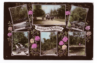
Postcard (item) - Colour postcard, Stanley Mullen Pty Ltd, Greetings from Victoria, Early 1900's
A colour postcard with six colour photographs of attractions in an around Marysville in Victoria. This postcard was produced by Stanley Mullen Pty Ltd. of Melbourne as a souvenir of Marysville.A colour postcard with four colour photographs of attractions in an around Marysville in Victoria.Greetings from Victoria The Yea River, Tallangi/ Resting, Fernshaw/ The Rapids, Watts River/ Waterfalls, Sylvia Creek/ Tram Track, Warburton/ Bush Bridge POST CARD Stanley Mullen Pty Ltd., Melbourne Printed in Germany Date Stamp-CARLTON NORTH-VICTORIA/ -2FE10 French stamp Ma soer voudrait favie/ les memes exchanges/ que moi. Son/ addresse est./ Miss. B. Coleman/ 95 Richardson St/ N. Carlton/ Avee mes meilleurs/ souhaits/ Votre tres devouee/ R. Coleman STAMP/ ON/ BACK Monsieur A. Rochet/ 22 Rue Longue,/ Lyon/ Rhone/ Francemarysville, victoria, yea river, tallangi, fernshaw, watts river, waterfall, sylvia creek, warburton, bridge, stanley mullen, postcard, souvenir, tram track -
 Flagstaff Hill Maritime Museum and Village
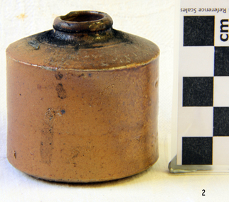
Container - Ink Bottle, Royal Doulton, Late 19th to early-20th century
The Royal Doulton company began as a partnership between John Doulton, Martha Jones, and John Watt was an English ceramic and home accessories manufacturer founded in 1815. Operating originally in Vauxhall, London, later moving to Lambeth, in 1882 it opened a factory in Burslem, Stoke-on-Trent, in the centre of English pottery. The business was specialised in making salt-glazed stoneware articles, including utilitarian or decorative bottles, jugs and jars, much of it intended for inns and pubs. The backbone of the business was a wide range of utilitarian wares, mostly stonewares, including storage jars, tankards and the like, and later extending to pipes for drains, lavatories and other bathroom ceramics. From 1853 to 1902 its wares were marked Doulton & Co., then from 1902, when a royal warrant was given, Royal Doulton. The company always made some more decorative items, initially still mostly stoneware, and from the 1860s the firm made considerable efforts to get a reputation for design, in which it was largely successful, as one of the first British makers of art pottery. Initially, this was done through artistic stoneware's made in Lambeth, but in 1882 the firm bought a Burslem factory, which was mainly intended for making bone China table wares and decorative items. An early utilitarian stoneware item made by a well-known company that specialised in making salt-glazed items that later earned a reputation for making stoneware art objects. This ink well is historically significant as it represents the method of hand written communication that was still common up until the mid-20th century, before fountain pens and ballpoint pens took over in popularity and convenience.Ceramic, salt-glazed, mid-brown ink bottle. It has a small round mouth, rounded lip that extends past neck, wide shoulders, straight sides, flat base. Handmade. The surface is matt. there are flecks of dark brown in the clay. The bottle has marks on the side.Noneflagstaff hill, warrnambool, shipwreck coast, flagstaff hill maritime museum, flagstaff hill maritime village, great ocean road, shipwreck artefact, writing equipment, writing accessory, office equipment, stationery, domestic, stoneware, clay, ceramic, pottery, inkwell, penny ink well, nib pen, dip pen, ink, hand writing, record keeping, household, business, vintage, blotting paper, ink bottle, dwarf ink, salt glazed -
 Forests Commission Retired Personnel Association (FCRPA)
Portable UHF Radio - Sawtron / Kyodo, c 1980s
After the 1939 bushfires, the Forests Commission invested heavily in a radically new communications network. After suffering some inevitable delays due to the War, radio VL3AA switched into full operation in October 1945 proudly beaming out 200 watts across the State. But by today’s standards, the technology was primitive and the reception poor unless the user was on a high point somewhere. The radio signal was "line-of-sight" and bounced between fire towers and relay transmitters across the mountains back to the District offices. Rapid improvements in technology led to various models of bulky handheld portables with heavy batteries that always seemed to go flat. In fact, batteries were a constant impediment at bushfires. The more secure and versatile State Mobile Radio (SMR) digital trunk system came into operation in about 1995. Upgraded Tait Radios were purchased in 2014 after recommendations of the 2009 Bushfires Royal Commission. But it was the convergence of separate technologies such as 4G mobile phones, high-capacity and light-weight lithium batteries, Wi-Fi, the ever-expanding internet, cloud data storage, digital cameras, GPS, personal organisers and hundreds of supporting Apps into powerful smartphones and tablets which revolutionised bushfire communications from the mid-2000s.Portable UHF Radio with leather carrying case and strap. Charging station. Kyodo Model KC-1109 MOYHU Whitfieldbushfire, radios, forests commission victoria (fcv) -
 Kew Historical Society Inc
Photograph - Irena Higgins, 1950s
Born in Poland in 1914, Irena Higgins completed her degree in social work at the University of Lwow [Lvov]. Migrating to Australia in 1938, she lived in various places including in Perth, Brisbane and Sydney before moving with her family to Melbourne in 1945. She initially worked at the Victorian Society for Crippled Children. Then in 1952, Irena was employed as a social worker by the Mental Hygiene Division of the Health Commission at Kew Mental Hospital (which included children). She was the first social worker employed by the Victorian Mental Health Authority to work with children with an intellectual disability. She remained at Kew for seventeen years, becoming Senior Social Worker with a staff of three other social workers, a secretary and a number of aides. Two of Irena’s significant innovations at Kew were the establishment of a Parents’ Association, and the development of a network of volunteers trained to work with families in the community. Irena Higgins remained committed to social reform following her retirement in 1984, working actively to establish the first emergency housing in Kew. In 2015, Irena’s daughter Barbara Higgins, and friend Elizabeth Watts, donated a number of her papers to the Kew Historical Society. These documents constitute the Irena Higgins Collection.Black and white photograph of Irena Higgins, donated by her daughter as part of the Irena Higgins Collection.irena higgins, kew mental hospital - willsmere, children's cottages (kew) -
 Bendigo Historical Society Inc.
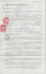
Document - H. A. & S. R. WILKINSON COLLECTION: FARM LEASE
Farm Lease dated 5th July 1957 between Mr. N. E. Watts and Mr. E. W. Traeger. Lease for all that piece of land being allotment 15B section 7 & allotment 15J & 15H of section 7, Parish of Neering in the state of Victoria containing 7 acres 14 perches or thereabouts with dwellings, out-houses and all improvements for the term of 1 year. Terms and conditions: the term of tenancy shall be from the 8th of July 1957 to the 8th July, 1958; the rent for said period shall be 5 pounds fortnightly, the lessee has the option of leasing the property for another 12 months at the same rental; the lessee has the option of purchasing the said property for the sum of 1,350 pounds. Chattels included: 1 draught horse, harness and swings, rubber tyres cart, green feed cutter2,30 dozen egg boxes, 3 ladders, tomato frames and glasses, single furrow plough, set harrows, cultivator, iron spike roller, scuffler, linos, blinds and curtains, ice chest and table. Lessee's copy.organization, business, h.a. & s.r wilkinson real estate -
 Ballarat Tramway Museum
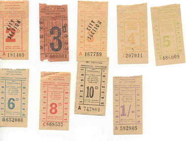
Ephemera - Ticket/s, State Electricity Commission of Victoria (SECV), Set of 9 mixed SEC tickets ex Bendigo, 1963 to 1965
Set of 9 mixed SEC tickets ex Bendigo, donated by Peter. W. Watt. Tickets do not appear to have been used in traffic - no punch marks. Tickets have not been individually numbered with the Registration Number, but can be identified by their ticket number and denomination. All on off white paper unless otherwise noted with a tartan style back unless noted. 3d - 1 -000001- orange paper, plain back, green ink price, black printing and number. 3d - City Section - A 167759 - light orange printing, over stamped in black ink. 2d - City Section - A 181409 - red print, over stamped in black ink. 4d - Z207011 - light brown printing, black number. 5d - B886009 - light green printing, black number. 6d - B652006 - teal printing, black number. 8d - C668537 - red ink, black number. 10d - A747801 - black ink, black number. 1/- - A592805 - purple printing, black ink. See Alan Bradley prepared scheduled of fares on SEC Systems. trams, tramways, tickets, secv, bendigo -
 Bendigo Historical Society Inc.
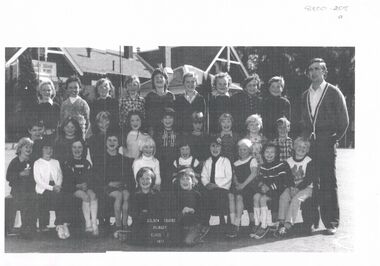
Photograph - GOLDEN SQUARE LAUREL STREET P.S. COLLECTION: PHOTOCOPIES OF PHOTOS
Photocopies of school photos: a. Class 2 1977, back row 2nd from left : Stuart MacGregor. Teacher Shane Rodda on right. B Grade 1, 1940. Names: back row: B. Stephenson, K. Eames, B. Matthews. A Holland, B. McEwan, J. Browell, Brennan, 3rd row : P. Barrett, E. Westgarth, D. Rogers, E. Wagstaff, I Watt, J. Collis, 2nd. Row W. Trahair, E. Rudd, J. Ryan, E. Tie, C. Little, E. Larter, J. Connelly, Front row: D. Lawry, M. Brown, C. Holiday, A. Cowling, S. Keast, V. Miccicans, E. Croft. C., Group of students, no names, grade unclear but appears 1990's ? D. Two photos, grade 2 and 3 1968 and Grades 2 and 3 1967, no names e. Group of students, formally dressed, girls in white, boys in collar and ties, jackets. Could be choir photo from early 1900's ? -
 Orbost & District Historical Society
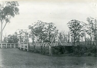
black and white photograph, August 1897
This is a photograph of the bridge from the Orbost side. The first pile bridge over the Snowy River was just completed by Mr Jim Granter when the 1891 flood took out the centre,. There were differences of opinion as to whether the council should pay . The Shire Secretary, Mr John Draffin, persuaded them to honour their obligations. Mr Granter and Mr Clarke finished it as a suspension bridge which was opened by Mrs William Watt. Soon after a mob of cattle stampeded, the weight snapped the cable, letting one side sag. Mr R.P. Cameron repaired it and this bridge remained until 1922. "In 1890 the contract for a bridge was let to Mr James Granter for £1450. This structure with additions and improvements made to it was to cost the ratepayers about £2,500, and its erection was proceeded with in a very satisfactory manner until, just as the greater-part of the work had been completed, the flood of 1891 came down on it, piling up mountains of logs, timber and debris against the piers, which had not been made wide enough apart to allow for. contingencies of this kind. The structure held out bravely until the turn of the flood and then gave way with a crash, about five bays from the centre disappearing in the stream." ( Snowy River Mail August 12 1893) This item is a pictorial record of one of the first bridges across the Snowy River in Orbost.A black / white photograph of the old wooden suspension bridge over the Snowy River. There are two copies 919.1 and 919.2. There are two other photos showing the whole bridge taken from further back.on back - "Orbost Bridge...."snowy-river-bridge-orbost granter-james -
 Eltham District Historical Society Inc
Photograph, Natasha Watts who was in Prep in 1983, now in Grade 6, Eltham Christian School, 1989, 1989
Natasha Watts who was in Prep in 1983, now in Grade 6, Eltham Christian School, 1989 The Stokes family settled in this area of Eltham in the 1940s and were associated with the Eltham Christian Church. In the 1970s this church had met in temporary premises in Eltham. Lots of the original 1920s subdivision remained south of Nyora Road and a number of these lots were utilized for the Eltham Christian School, which was established by the Eltham Christian Church in 1981. The school operated on this site until 2000. The premises were owned by the Nillumbik Community Church who were in operation till November 2010 when the Eltham Baptist Church commenced a lease arrangement until the site was purchased by them in April 2012. The building is constructed of brick and timber with a balcony on two sides that looks over an expanse of grass. Sources: STOKES ORCHARD – AN INCOMPLETE HISTORY February 28, 2015 http://www.elthamhistory.org.au/ Australian Christian Church Histories - Eltham Baptist Church http://www.churchhistories.net.au/church-catalog/eltham-vic-baptist/ From a magnetic spiral bound photo album featuring a series of photographs (some cropped) with captions relating to the staff, students and activities of the Eltham Christian School which operated as part of the Eltham Christian Church at Nyora Road, Eltham. See also entries for each photograph.colour photographeltham christian school, nyora road, natasha watts -
 Eltham District Historical Society Inc
Photograph, Prep/Grade 1; Natasha Watts, Cory Giesbrecht, Eltham Christian School, March 1983, 1983
Prep/Grade 1; Natasha Watts, Cory Giesbrecht, Eltham Christian School, March 1983 The Stokes family settled in this area of Eltham in the 1940s and were associated with the Eltham Christian Church. In the 1970s this church had met in temporary premises in Eltham. Lots of the original 1920s subdivision remained south of Nyora Road and a number of these lots were utilized for the Eltham Christian School, which was established by the Eltham Christian Church in 1981. The school operated on this site until 2000. The premises were owned by the Nillumbik Community Church who were in operation till November 2010 when the Eltham Baptist Church commenced a lease arrangement until the site was purchased by them in April 2012. The building is constructed of brick and timber with a balcony on two sides that looks over an expanse of grass. Sources: STOKES ORCHARD – AN INCOMPLETE HISTORY February 28, 2015 http://www.elthamhistory.org.au/ Australian Christian Church Histories - Eltham Baptist Church http://www.churchhistories.net.au/church-catalog/eltham-vic-baptist/ From an album featuring a series of photographs (some cropped) from a magnetic photo album relating to the staff, students and activities of the Eltham Christian School which operated as part of the Eltham Christian Church at Nyora Road, Eltham. See also entries for each photograph.Colour photographeltham christian school, nyora road, natasha watts, cory giesbrecht -
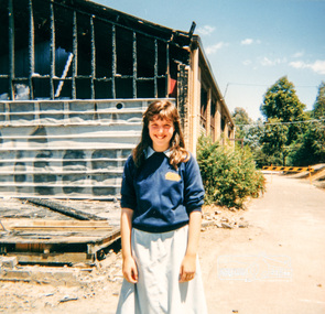
 Eltham District Historical Society Inc
Photograph, Grade 4: Susan Field, Darren Watts, Stephanie Giesbrecht, Eltham Christian School, March 1983, 1983
Grade 4: Susan Field, Darren Watts, Stephanie Giesbrecht, Eltham Christian School, March 1983 The Stokes family settled in this area of Eltham in the 1940s and were associated with the Eltham Christian Church. In the 1970s this church had met in temporary premises in Eltham. Lots of the original 1920s subdivision remained south of Nyora Road and a number of these lots were utilized for the Eltham Christian School, which was established by the Eltham Christian Church in 1981. The school operated on this site until 2000. The premises were owned by the Nillumbik Community Church who were in operation till November 2010 when the Eltham Baptist Church commenced a lease arrangement until the site was purchased by them in April 2012. The building is constructed of brick and timber with a balcony on two sides that looks over an expanse of grass. Sources: STOKES ORCHARD – AN INCOMPLETE HISTORY February 28, 2015 http://www.elthamhistory.org.au/ Australian Christian Church Histories - Eltham Baptist Church http://www.churchhistories.net.au/church-catalog/eltham-vic-baptist/ From an album featuring a series of photographs (some cropped) from a magnetic photo album relating to the staff, students and activities of the Eltham Christian School which operated as part of the Eltham Christian Church at Nyora Road, Eltham. See also entries for each photograph.Colour photographeltham christian school, nyora road, susan field, darren watts, stephanie giesbrecht -
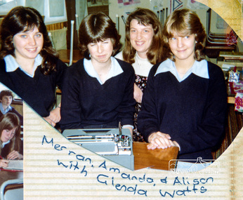 Eltham District Historical Society Inc
Photograph, Merrin Bradbury, Amanda Doedens, Alison Skingle with Glenda Watts, Eltham Christian School, 1982, 1982
Merrin Bradbury, Amanda Doedens, Alison Skingle with Glenda Watts, Eltham Christian School, 1982 The Stokes family settled in this area of Eltham in the 1940s and were associated with the Eltham Christian Church. In the 1970s this church had met in temporary premises in Eltham. Lots of the original 1920s subdivision remained south of Nyora Road and a number of these lots were utilized for the Eltham Christian School, which was established by the Eltham Christian Church in 1981. The school operated on this site until 2000. The premises were owned by the Nillumbik Community Church who were in operation till November 2010 when the Eltham Baptist Church commenced a lease arrangement until the site was purchased by them in April 2012. The building is constructed of brick and timber with a balcony on two sides that looks over an expanse of grass. Sources: STOKES ORCHARD – AN INCOMPLETE HISTORY February 28, 2015 http://www.elthamhistory.org.au/ Australian Christian Church Histories - Eltham Baptist Church http://www.churchhistories.net.au/church-catalog/eltham-vic-baptist/ From an album featuring a series of photographs (some cropped) from a magnetic photo album relating to the staff, students and activities of the Eltham Christian School which operated as part of the Eltham Christian Church at Nyora Road, Eltham. See also entries for each photograph.colour photographeltham christian school, nyora road, merrin bradbury, amanda doedens, alison skingle, glenda watts -
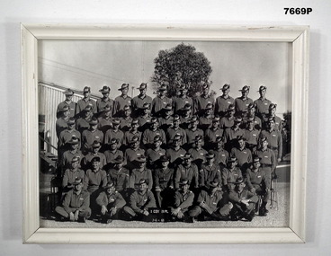 Bendigo Military Museum
Photograph - PHOTOGRAPH, FRAMED, C. June1969
Photograph re 16th Intake National Service 23/4/1969 Recruit Training 20 Platoon D Coy Puckapunyal. Photo in the collection re Peter Ball, refer Cat No 4704 for service/other details Platoon names, surname only. Back row. Russell, Rennie, Carter, Henning, McMurrich, Golding, McLeay, Span, Musgrave, Tinney, Pitt. Fifth row. Flowers, McNair, Coates, Raco (Sam), Moon, Albert, DeJong, Taylor, Morgan, Burrows, Culp. Fourth Row. Wakeling, Fuller (Bob), Melbourne, Guistino, Thorpe, Forbes (Wayne), Alexander, Tirrell (Roger) Ellingham, Bloom, Freeman. Third row. Johnson, Watts, Tellis, Rankin, Whatmough, Goldsmith, Kopke, Thomas (Courtney), Darker, Lonergan. Second row. Russo, Cpl Brabrowsky, Cpl Eather, Cpl Richards, 2nd Lt Boag, Cpl Logan, Cpl Beasley, Robertson, Thompson. Front row. Dann, Hore, Ball (Peter), Luke (David), Clay, Missing. Sgt Simms, O'Donnell, Roberts, McHenry, Harris, Johns, Maher, Parmenta. Served in Vietnam later that is known. Henning, Fuller, Forbes, Thomas, Ball, Luke, Johns. Cpls Eather, Richards & Beasley had already served in Vietnam'. Thorpe served in Malaya later. Black and white photo of 20th Platoon, D Company. Six (6) rows of soldiers in uniform posed on the Parade Ground in front of building at Puckapunyal on 7th June 1969. Photo is in a white frame (wooden) with a glass front. Brown cardboard backboard with built in stand stapled to back.On back written "16th Intake" x "8 x6".puckapunyal, training, photograph, 20th platoon -
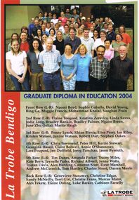 Bendigo Historical Society Inc.
Document - LA TROBE UNIVERSITY BENDIGO COLLECTION: GRADUATE DIPLOMA IN EDUCATION 2004
A laminated copy of the "Graduate Diploma in Education 2004". It displays a photo and the names of the recipients - Naomi Boyd, Sophie Gaballa, David Young, Bing Ge, Maggie Francis, Mohammad Khalaf, Vaughan Prain, Elaine Toogood, Kristina Zeravica, Linda Savva, Jodie Long, Bradley Rankin, Bradley Palmer, Ngaire Breen, June Zhu (Julia), Marita Haigh, Penny Lynch, Rhian Birnie, Elise Perry, Ian Riley, Kristen Watson, Janine Watson, Robert Dart, Stephen Oakes, Chris Townsend, Peter Hill, Kerrie Stewart, Ceorgina Hasell, Claire Bolwell, Annie O'Shannessy, Lara Poupard, Jen Duffield, Joerg Parschau, Jason Bysouth, Tim Danes, Amanda Parker, Tracey Miles, Kate Berry, Jaynelle Parks, Richard Allwell, Jenny Watts, Tristan Davis, Alex Harding, Cameron Scott, Dave Marshall, Andrew McCormick, Tom Hartley, Charles Street, Darren Moyle, Genevieve Stanaway, Christine Edgar, Sandy McNeilly, Terri Giri, Christine Evans, Marcus Mann, Alex Fekete, Elaine Doling, Luke Barker and Cathleen Farrelly.bendigo, education, la trobe university bendigo, la trobe university bendigo collection, collection, bendigo, education, teaching, teachers, students, diploma, graduate diploma, tertiary education -
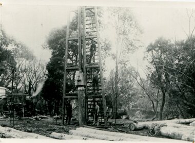 Orbost & District Historical Society
black and white photograph, C1890
This photograph shows the construction of the first bridge over the Snowy River at Orbost being built. a copy was also donated by Gil and Heather Richardson. The first pile bridge over the Snowy River was just completed by Mr Jim Granter when the 1891 flood took out the centre,. There were differences of opinion as to whether the council should pay . The Shire Secretary, Mr John Draffin, persuaded them to honour their obligations. Mr Granter and Mr Clarke finished it as a suspension bridge which was opened by Mrs William Watt. Soon after a mob of cattle stampeded, the weight snapped the cable, letting one side sag. Mr R.P. Cameron repaired it and this bridge remained until 1922. "In 1890 the contract for a bridge was let to Mr James Granter for £1450. This structure with additions and improvements made to it was to cost the ratepayers about £2,500, and its erection was proceeded with in a very satisfactory manner until, just as the greater-part of the work had been completed, the flood of 1891 came down on it, piling up mountains of logs, timber and debris against the piers, which had not been made wide enough apart to allow for. contingencies of this kind. The structure held out bravely until the turn of the flood and then gave way with a crash, about five bays from the centre disappearing in the stream." ( Snowy River Mail August 12 1893)This is a pictorial record of the construction of the first bridge over the Snowy River.A black / white photograph of four men working on the construction of a new bridge and its pylons a man is standing on a timber tower/ derrick. There are logs in the foreground, trees in the background. sheds on the left and possibly a steam engine.on back - "first bridge - 1st pile being driven"snowy-river-bridge granter-jim bridge -
 Federation University Historical Collection
Book - Catalogue, Disruption By Design: Intentional Catalyst for Change, 2012
This publication accompanied the exhibition of UB Bachelor of Visual Arts (Graphic Design) graduate students which ran from 23 November to 2 December 2012. Foreword by Professor John McDonald, Dean, School of Education and Arts, and by "Inkahoots" design studio. Student list: Christopher Frith, James Croft, Jesse Mason, Andrew Cox, Daniel Roache, Jenna Locket, Aaron Croft, Emily Phillips, Caitlin Heimeier, Maddy Collicoat, Brayden Waight, Elisa Micallef, Danii Zecevic, Zoe-Lee Scriven, Carla Ellis, Bryce Holywell, Lindsay Sewart, Megan Sutherland, Steven Fiume, Brianna Wines, Matt Sullivan, Alyssa Roberts, Hayley Burman, Jacqui Leutenmayr, Jessica Weston, Kimberley Wilson, Georgia Clarke, Josh Fry, Breanna Dignan, Lucy-Ann Moore, Tom Miatke, Daniel Howard, Matt Watts. 33 students. Inside back cover, thanks supporters, lecturers and sponsors. Lecturers: Ben Mangan, Chrissie Smith, Gavin Nash, Luke Keys, Glen Bellman, Travis Price, Sam Harmer, Damian Lentini, Jennifer Jones-O'Neill, Jimmy Pasakos, Pete Swan and Peter Pilven. Book layout and design by Aaron Croft, James Croft and Daniel Howard. Note: "Multimedia" has been removed from the degree title here.Promotional catalogue created by University of Ballarat, Bachelor of Visual Arts (Graphic Design) third year, graduating students, 2012. 40pp text pages (printed orange, silver and black) and 4pp saddle stitched cover (printed orange and silver), uncoated stock.university of ballarat, federation university, graphic design, multimedia, bachelor, degree, camp street campus, arts academy, christopher frith, james croft, jesse mason, andrew cox, daniel roache, jenna locket, aaron croft, emily phillips, caitlin heimeier, maddy collicoat, brayden waight, elisa micallef, danii zecevic, zoe-lee scriven, carla ellis, bryce holywell, lindsay sewart, megan sutherland, steven fiume, brianna wines, matt sullivan, alyssa roberts, hayley burman, jacqui leutenmayr, jessica weston, kimberley wilson, georgia clarke, josh fry, breanna dignan, lucy-ann moore, tom miatke, daniel howard, matt watts, ben mangan, chrissie smith, gavin nash, luke keys, glen bellman, travis price, sam harmer, damian lentini, jennifer jones-o'neill, jimmy pasakos, pete swan and peter pilven -
 Eltham District Historical Society Inc
Photograph, Liz Pidgeon, Heritage Excursion; Maroondah Aqueduct, 3 September 2016, 3 September 2016
Newsletter No., 229, August 2016 Heritage Excursion - Maroondah Aqueduct Walk - Saturday 3rd September The Maroondah Aqueduct was once a major link in Melbourne’s water supply system. It was built between 1886 and 1891 to transfer water from the Watts River near Healesville to the Preston Reservoir. It was 66 km in length, made up of 41 km of open channel, 10 km of tunnel through hills and 15 km of pipeline across stream valleys known as inverted siphons. The section of the aqueduct through the Eltham area has been abandoned since the 1980s but the open channel has largely been retained. A recreational path follows the aqueduct reserve. For our excursion on 3rd September we intend to walk along the section of the aqueduct adjacent to Allendale Road. This is a section not visited on previous excursions and includes the transition from open channel to the inverted siphon across the Diamond Creek valley. Apart from the aqueduct itself the main feature of the walk is the extensive views across Eltham North and Diamond Creek. Along the way we will talk about the history of the aqueduct and the area. This easy walk is about 3 km return and will take 2 to 2.5 hours. It will start at 2pm at the junction of Allendale Road with Godber Road and Zig Zag Road North, officially Diamond Creek, but on the northern boundary of Eltham. (Melway ref.12 B10). Born Digitalmaroondah aqueduct, eltham north, activities, eltham district historical society, heritage excursion, acqueduct trail, sign -
 Eltham District Historical Society Inc
Photograph, Liz Pidgeon, Heritage Excursion; Maroondah Aqueduct, 3 September 2016, 3 September 2016
Newsletter No., 229, August 2016 Heritage Excursion - Maroondah Aqueduct Walk - Saturday 3rd September The Maroondah Aqueduct was once a major link in Melbourne’s water supply system. It was built between 1886 and 1891 to transfer water from the Watts River near Healesville to the Preston Reservoir. It was 66 km in length, made up of 41 km of open channel, 10 km of tunnel through hills and 15 km of pipeline across stream valleys known as inverted siphons. The section of the aqueduct through the Eltham area has been abandoned since the 1980s but the open channel has largely been retained. A recreational path follows the aqueduct reserve. For our excursion on 3rd September we intend to walk along the section of the aqueduct adjacent to Allendale Road. This is a section not visited on previous excursions and includes the transition from open channel to the inverted siphon across the Diamond Creek valley. Apart from the aqueduct itself the main feature of the walk is the extensive views across Eltham North and Diamond Creek. Along the way we will talk about the history of the aqueduct and the area. This easy walk is about 3 km return and will take 2 to 2.5 hours. It will start at 2pm at the junction of Allendale Road with Godber Road and Zig Zag Road North, officially Diamond Creek, but on the northern boundary of Eltham. (Melway ref.12 B10). Born Digitalmaroondah aqueduct, eltham north, activities, eltham district historical society, heritage excursion, acqueduct trail, diamond creek -
 Eltham District Historical Society Inc
Photograph, Liz Pidgeon, Heritage Excursion; Maroondah Aqueduct, 3 September 2016, 3 September 2016
Newsletter No., 229, August 2016 Heritage Excursion - Maroondah Aqueduct Walk - Saturday 3rd September The Maroondah Aqueduct was once a major link in Melbourne’s water supply system. It was built between 1886 and 1891 to transfer water from the Watts River near Healesville to the Preston Reservoir. It was 66 km in length, made up of 41 km of open channel, 10 km of tunnel through hills and 15 km of pipeline across stream valleys known as inverted siphons. The section of the aqueduct through the Eltham area has been abandoned since the 1980s but the open channel has largely been retained. A recreational path follows the aqueduct reserve. For our excursion on 3rd September we intend to walk along the section of the aqueduct adjacent to Allendale Road. This is a section not visited on previous excursions and includes the transition from open channel to the inverted siphon across the Diamond Creek valley. Apart from the aqueduct itself the main feature of the walk is the extensive views across Eltham North and Diamond Creek. Along the way we will talk about the history of the aqueduct and the area. This easy walk is about 3 km return and will take 2 to 2.5 hours. It will start at 2pm at the junction of Allendale Road with Godber Road and Zig Zag Road North, officially Diamond Creek, but on the northern boundary of Eltham. (Melway ref.12 B10). Born Digitalmaroondah aqueduct, eltham north, activities, eltham district historical society, heritage excursion, acqueduct trail, sign -
 Eltham District Historical Society Inc
Photograph, Liz Pidgeon, Heritage Excursion; Maroondah Aqueduct, 3 September 2016, 3 September 2016
Newsletter No., 229, August 2016 Heritage Excursion - Maroondah Aqueduct Walk - Saturday 3rd September The Maroondah Aqueduct was once a major link in Melbourne’s water supply system. It was built between 1886 and 1891 to transfer water from the Watts River near Healesville to the Preston Reservoir. It was 66 km in length, made up of 41 km of open channel, 10 km of tunnel through hills and 15 km of pipeline across stream valleys known as inverted siphons. The section of the aqueduct through the Eltham area has been abandoned since the 1980s but the open channel has largely been retained. A recreational path follows the aqueduct reserve. For our excursion on 3rd September we intend to walk along the section of the aqueduct adjacent to Allendale Road. This is a section not visited on previous excursions and includes the transition from open channel to the inverted siphon across the Diamond Creek valley. Apart from the aqueduct itself the main feature of the walk is the extensive views across Eltham North and Diamond Creek. Along the way we will talk about the history of the aqueduct and the area. This easy walk is about 3 km return and will take 2 to 2.5 hours. It will start at 2pm at the junction of Allendale Road with Godber Road and Zig Zag Road North, officially Diamond Creek, but on the northern boundary of Eltham. (Melway ref.12 B10). Born Digitalmaroondah aqueduct, eltham north, activities, eltham district historical society, heritage excursion, acqueduct trail -
 Eltham District Historical Society Inc
Photograph, Liz Pidgeon, Heritage Excursion; Maroondah Aqueduct, 3 September 2016, 3 September 2016
Intersection with local Street signs Newsletter No., 229, August 2016 Heritage Excursion - Maroondah Aqueduct Walk - Saturday 3rd September The Maroondah Aqueduct was once a major link in Melbourne’s water supply system. It was built between 1886 and 1891 to transfer water from the Watts River near Healesville to the Preston Reservoir. It was 66 km in length, made up of 41 km of open channel, 10 km of tunnel through hills and 15 km of pipeline across stream valleys known as inverted siphons. The section of the aqueduct through the Eltham area has been abandoned since the 1980s but the open channel has largely been retained. A recreational path follows the aqueduct reserve. For our excursion on 3rd September we intend to walk along the section of the aqueduct adjacent to Allendale Road. This is a section not visited on previous excursions and includes the transition from open channel to the inverted siphon across the Diamond Creek valley. Apart from the aqueduct itself the main feature of the walk is the extensive views across Eltham North and Diamond Creek. Along the way we will talk about the history of the aqueduct and the area. This easy walk is about 3 km return and will take 2 to 2.5 hours. It will start at 2pm at the junction of Allendale Road with Godber Road and Zig Zag Road North, officially Diamond Creek, but on the northern boundary of Eltham. (Melway ref.12 B10). Born Digitalmaroondah aqueduct, eltham north, activities, eltham district historical society, heritage excursion, street signs, acqueduct trail, allendale rd, godber rd, zig zag road, intersection -
 Eltham District Historical Society Inc
Photograph, Liz Pidgeon, Heritage Excursion; Maroondah Aqueduct, 3 September 2016, 3 September 2016
Newsletter No., 229, August 2016 Heritage Excursion - Maroondah Aqueduct Walk - Saturday 3rd September The Maroondah Aqueduct was once a major link in Melbourne’s water supply system. It was built between 1886 and 1891 to transfer water from the Watts River near Healesville to the Preston Reservoir. It was 66 km in length, made up of 41 km of open channel, 10 km of tunnel through hills and 15 km of pipeline across stream valleys known as inverted siphons. The section of the aqueduct through the Eltham area has been abandoned since the 1980s but the open channel has largely been retained. A recreational path follows the aqueduct reserve. For our excursion on 3rd September we intend to walk along the section of the aqueduct adjacent to Allendale Road. This is a section not visited on previous excursions and includes the transition from open channel to the inverted siphon across the Diamond Creek valley. Apart from the aqueduct itself the main feature of the walk is the extensive views across Eltham North and Diamond Creek. Along the way we will talk about the history of the aqueduct and the area. This easy walk is about 3 km return and will take 2 to 2.5 hours. It will start at 2pm at the junction of Allendale Road with Godber Road and Zig Zag Road North, officially Diamond Creek, but on the northern boundary of Eltham. (Melway ref.12 B10). Born Digitalmaroondah aqueduct, eltham north, activities, eltham district historical society, heritage excursion, acqueduct trail -
 Eltham District Historical Society Inc
Photograph, Liz Pidgeon, Heritage Excursion; Maroondah Aqueduct, 3 September 2016, 3 September 2016
Property related to Yarra Valley Water, Diamond Creek Newsletter No., 229, August 2016 Heritage Excursion - Maroondah Aqueduct Walk - Saturday 3rd September The Maroondah Aqueduct was once a major link in Melbourne’s water supply system. It was built between 1886 and 1891 to transfer water from the Watts River near Healesville to the Preston Reservoir. It was 66 km in length, made up of 41 km of open channel, 10 km of tunnel through hills and 15 km of pipeline across stream valleys known as inverted siphons. The section of the aqueduct through the Eltham area has been abandoned since the 1980s but the open channel has largely been retained. A recreational path follows the aqueduct reserve. For our excursion on 3rd September we intend to walk along the section of the aqueduct adjacent to Allendale Road. This is a section not visited on previous excursions and includes the transition from open channel to the inverted siphon across the Diamond Creek valley. Apart from the aqueduct itself the main feature of the walk is the extensive views across Eltham North and Diamond Creek. Along the way we will talk about the history of the aqueduct and the area. This easy walk is about 3 km return and will take 2 to 2.5 hours. It will start at 2pm at the junction of Allendale Road with Godber Road and Zig Zag Road North, officially Diamond Creek, but on the northern boundary of Eltham. (Melway ref.12 B10). Born Digitalmaroondah aqueduct, eltham north, activities, eltham district historical society, heritage excursion, yarra valley water, diamond creek -
 Eltham District Historical Society Inc
Photograph, Liz Pidgeon, Heritage Excursion; Maroondah Aqueduct, 3 September 2016, 3 September 2016
Sign for Yarra Valley Water at Diamond Creek property Newsletter No., 229, August 2016 Heritage Excursion - Maroondah Aqueduct Walk - Saturday 3rd September The Maroondah Aqueduct was once a major link in Melbourne’s water supply system. It was built between 1886 and 1891 to transfer water from the Watts River near Healesville to the Preston Reservoir. It was 66 km in length, made up of 41 km of open channel, 10 km of tunnel through hills and 15 km of pipeline across stream valleys known as inverted siphons. The section of the aqueduct through the Eltham area has been abandoned since the 1980s but the open channel has largely been retained. A recreational path follows the aqueduct reserve. For our excursion on 3rd September we intend to walk along the section of the aqueduct adjacent to Allendale Road. This is a section not visited on previous excursions and includes the transition from open channel to the inverted siphon across the Diamond Creek valley. Apart from the aqueduct itself the main feature of the walk is the extensive views across Eltham North and Diamond Creek. Along the way we will talk about the history of the aqueduct and the area. This easy walk is about 3 km return and will take 2 to 2.5 hours. It will start at 2pm at the junction of Allendale Road with Godber Road and Zig Zag Road North, officially Diamond Creek, but on the northern boundary of Eltham. (Melway ref.12 B10). Born Digitalmaroondah aqueduct, eltham north, activities, eltham district historical society, heritage excursion, diamond creek, yarra valley water, sign -
 Eltham District Historical Society Inc
Photograph, Liz Pidgeon, Heritage Excursion; Maroondah Aqueduct, 3 September 2016, 3 September 2016
Newsletter No., 229, August 2016 Heritage Excursion - Maroondah Aqueduct Walk - Saturday 3rd September The Maroondah Aqueduct was once a major link in Melbourne’s water supply system. It was built between 1886 and 1891 to transfer water from the Watts River near Healesville to the Preston Reservoir. It was 66 km in length, made up of 41 km of open channel, 10 km of tunnel through hills and 15 km of pipeline across stream valleys known as inverted siphons. The section of the aqueduct through the Eltham area has been abandoned since the 1980s but the open channel has largely been retained. A recreational path follows the aqueduct reserve. For our excursion on 3rd September we intend to walk along the section of the aqueduct adjacent to Allendale Road. This is a section not visited on previous excursions and includes the transition from open channel to the inverted siphon across the Diamond Creek valley. Apart from the aqueduct itself the main feature of the walk is the extensive views across Eltham North and Diamond Creek. Along the way we will talk about the history of the aqueduct and the area. This easy walk is about 3 km return and will take 2 to 2.5 hours. It will start at 2pm at the junction of Allendale Road with Godber Road and Zig Zag Road North, officially Diamond Creek, but on the northern boundary of Eltham. (Melway ref.12 B10). Born Digitalmaroondah aqueduct, eltham north, activities, eltham district historical society, heritage excursion, acqueduct trail -
 Eltham District Historical Society Inc
Photograph, Liz Pidgeon, Heritage Excursion; Maroondah Aqueduct, 3 September 2016, 3 September 2016
View of Diamond Creek Newsletter No., 229, August 2016 Heritage Excursion - Maroondah Aqueduct Walk - Saturday 3rd September The Maroondah Aqueduct was once a major link in Melbourne’s water supply system. It was built between 1886 and 1891 to transfer water from the Watts River near Healesville to the Preston Reservoir. It was 66 km in length, made up of 41 km of open channel, 10 km of tunnel through hills and 15 km of pipeline across stream valleys known as inverted siphons. The section of the aqueduct through the Eltham area has been abandoned since the 1980s but the open channel has largely been retained. A recreational path follows the aqueduct reserve. For our excursion on 3rd September we intend to walk along the section of the aqueduct adjacent to Allendale Road. This is a section not visited on previous excursions and includes the transition from open channel to the inverted siphon across the Diamond Creek valley. Apart from the aqueduct itself the main feature of the walk is the extensive views across Eltham North and Diamond Creek. Along the way we will talk about the history of the aqueduct and the area. This easy walk is about 3 km return and will take 2 to 2.5 hours. It will start at 2pm at the junction of Allendale Road with Godber Road and Zig Zag Road North, officially Diamond Creek, but on the northern boundary of Eltham. (Melway ref.12 B10). Born Digitalmaroondah aqueduct, eltham north, activities, eltham district historical society, heritage excursion, diamond creek, acqueduct trail -
 Eltham District Historical Society Inc
Photograph, Liz Pidgeon, Heritage Excursion; Maroondah Aqueduct, 3 September 2016, 3 September 2016
Russell Yeomann provides historical information on the heritage excursion From the Newsletter No., 229, August 2016 Heritage Excursion - Maroondah Aqueduct Walk - Saturday 3rd September The Maroondah Aqueduct was once a major link in Melbourne’s water supply system. It was built between 1886 and 1891 to transfer water from the Watts River near Healesville to the Preston Reservoir. It was 66 km in length, made up of 41 km of open channel, 10 km of tunnel through hills and 15 km of pipeline across stream valleys known as inverted siphons. The section of the aqueduct through the Eltham area has been abandoned since the 1980s but the open channel has largely been retained. A recreational path follows the aqueduct reserve. For our excursion on 3rd September we intend to walk along the section of the aqueduct adjacent to Allendale Road. This is a section not visited on previous excursions and includes the transition from open channel to the inverted siphon across the Diamond Creek valley. Apart from the aqueduct itself the main feature of the walk is the extensive views across Eltham North and Diamond Creek. Along the way we will talk about the history of the aqueduct and the area. This easy walk is about 3 km return and will take 2 to 2.5 hours. It will start at 2pm at the junction of Allendale Road with Godber Road and Zig Zag Road North, officially Diamond Creek, but on the northern boundary of Eltham. (Melway ref.12 B10). Born Digitalmaroondah aqueduct, eltham north, activities, eltham district historical society, heritage excursion, russell yeoman, aqueduct trail -
 Eltham District Historical Society Inc
Photograph, Liz Pidgeon, Heritage Excursion; Maroondah Aqueduct, 3 September 2016, 3 September 2016
Newsletter No., 229, August 2016 Heritage Excursion - Maroondah Aqueduct Walk - Saturday 3rd September The Maroondah Aqueduct was once a major link in Melbourne’s water supply system. It was built between 1886 and 1891 to transfer water from the Watts River near Healesville to the Preston Reservoir. It was 66 km in length, made up of 41 km of open channel, 10 km of tunnel through hills and 15 km of pipeline across stream valleys known as inverted siphons. The section of the aqueduct through the Eltham area has been abandoned since the 1980s but the open channel has largely been retained. A recreational path follows the aqueduct reserve. For our excursion on 3rd September we intend to walk along the section of the aqueduct adjacent to Allendale Road. This is a section not visited on previous excursions and includes the transition from open channel to the inverted siphon across the Diamond Creek valley. Apart from the aqueduct itself the main feature of the walk is the extensive views across Eltham North and Diamond Creek. Along the way we will talk about the history of the aqueduct and the area. This easy walk is about 3 km return and will take 2 to 2.5 hours. It will start at 2pm at the junction of Allendale Road with Godber Road and Zig Zag Road North, officially Diamond Creek, but on the northern boundary of Eltham. (Melway ref.12 B10). Born Digitalmaroondah aqueduct, eltham north, activities, eltham district historical society, heritage excursion, water-pipes, pipes, cattle yard, aqueduct trail -
 Eltham District Historical Society Inc
Photograph, Liz Pidgeon, Heritage Excursion; Maroondah Aqueduct, 3 September 2016, 3 September 2016
Newsletter No., 229, August 2016 Heritage Excursion - Maroondah Aqueduct Walk - Saturday 3rd September The Maroondah Aqueduct was once a major link in Melbourne’s water supply system. It was built between 1886 and 1891 to transfer water from the Watts River near Healesville to the Preston Reservoir. It was 66 km in length, made up of 41 km of open channel, 10 km of tunnel through hills and 15 km of pipeline across stream valleys known as inverted siphons. The section of the aqueduct through the Eltham area has been abandoned since the 1980s but the open channel has largely been retained. A recreational path follows the aqueduct reserve. For our excursion on 3rd September we intend to walk along the section of the aqueduct adjacent to Allendale Road. This is a section not visited on previous excursions and includes the transition from open channel to the inverted siphon across the Diamond Creek valley. Apart from the aqueduct itself the main feature of the walk is the extensive views across Eltham North and Diamond Creek. Along the way we will talk about the history of the aqueduct and the area. This easy walk is about 3 km return and will take 2 to 2.5 hours. It will start at 2pm at the junction of Allendale Road with Godber Road and Zig Zag Road North, officially Diamond Creek, but on the northern boundary of Eltham. (Melway ref.12 B10). Born Digitalmaroondah aqueduct, eltham north, activities, eltham district historical society, heritage excursion, aqueduct trail, cattle yard