Showing 27615 items
matching yarra-river
-
 Upper Yarra Museum
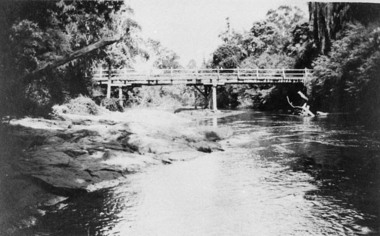
Negative Photographic Reproduction, Bridge over Yarra at the Doon, 1911, Yarra Junction
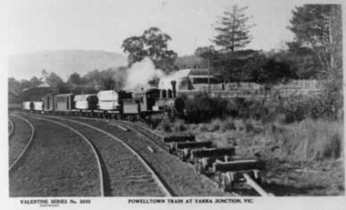
PC Valentine 2650 Powelltown timber train at Yarra Junction Negative Black white Scanned at 600 dpi. -
 Kew Historical Society Inc
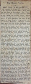
Newspaper - Article, The Upper Yarra: boat traffic endangered, 1918-20
An item of ephemera relating to tourism and recreation on the Yarra River in Melbourne in the first half of the twentieth century.An item from a large collection assembled by the Christian and Washfold families of Kew, including photographs, postcards, and ephemera. Many of the items in the Christian-Washfold Collection relate to the Yarra River and its use as as a recreational resource. Numerous items in the collection are historically important in that they are rare and often unique records of vanished locations or past recreational activities.Article describing the effects of the partial collapse of the weir at Dight’s Falls and its impact on water levels between Kew, Fairfield, and Heidelberg. The article is undated however as it describes Cr Harry Tompkins as Mayor of Kew it must date to the years 1918-20.christian-washfold collection, river yarra -- recreation, dight's falls -
 Marysville & District Historical Society
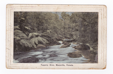
Postcard (item) - Colour tinted postcard, Renwick, Pride & Nuttall, Taggerty River, Marysville, Victoria, 1916
An early colour tinted photograph of the Taggerty River in Marysville in Victoria.An early colour tinted photograph of the Taggerty River in Marysville in Victoria.Australian Enamellers. Country Series No. 3. Produced in Australia To Ms Marlene./ To wish you/ well; & To assist in/ making you as comfy/ as possible. I hope you/ are keeping well & fit/ & that it wont be long/ before you are on your/ way back to Aust. I/ suppose you have heard/ that Jack is on his/ way home, we are/ looking forward to/ the day when he arrives./ My best wishes to you/ & kind regards/ Sincerely yr/ friend/ Raell Dennistaggerty river, marysville, victoria, postcard, souvenir -
 Eltham District Historical Society Inc
Photograph, George W. Bell, Birch Cottage, Yarra Glen Road, Smiths Gully, Aug 1969, Aug 1969
EDHS Newsletter No. 182, September 2008 In the late 1970s when our Society was the Shire of Eltham Historical Society, an offer was made to the Society regarding use of an old cottage at Christmas Hills. For various reasons the offer ultimately lapsed The cottage sat beside Watsons Creek just outside the then Shire of Eltham but following municipal restructuring it now lies within the Shire of Nillumbik. At that time some research on the cottage was carried out for the Society by Keith Chappel as part of a larger research project that he was doing. Keith's notes were taken from Lands Department records and showed that house is the subject of a permissive occupancy of Crown land comprising the creek reserve. In 1903 a Miners Right of one acre in area was granted to Edwin Samuel Birch. In 1907 Birch applied to purchase this land but was unable to because it was part of the creek reserve. The documents show that the house existed at that time. Birch died in 1932 and his daughter Honor Mary Birch was granted a permit to occupy the residence. The future of the cottage remains precarious because of its location on Crown land. In 2007 the Andrew Ross Museum began a campaign to ensure that it is preserved. It included a video presentation on the history of the cottage under the title of "This Old House- Birch Cottage". Black and white photographWilliams Cottage Panton Hill 1969 Not to be reproduced without permission G.W. Bell Photographer Elthamhouses, cottage, early settlers, yarra glen road, smiths gully, williams cottage, watsons creek, christmas hills, birch cottage, edwin samuel birch, honor mary birch -
 Eltham District Historical Society Inc
Photograph, George W. Bell, Detail, Kitchen, Birch Cottage, Yarra Glen Road, Smiths Gully, Aug 1969, Aug 1969
EDHS Newsletter No. 182, September 2008 In the late 1970s when our Society was the Shire of Eltham Historical Society, an offer was made to the Society regarding use of an old cottage at Christmas Hills. For various reasons the offer ultimately lapsed The cottage sat beside Watsons Creek just outside the then Shire of Eltham but following municipal restructuring it now lies within the Shire of Nillumbik. At that time some research on the cottage was carried out for the Society by Keith Chappel as part of a larger research project that he was doing. Keith's notes were taken from Lands Department records and showed that house is the subject of a permissive occupancy of Crown land comprising the creek reserve. In 1903 a Miners Right of one acre in area was granted to Edwin Samuel Birch. In 1907 Birch applied to purchase this land but was unable to because it was part of the creek reserve. The documents show that the house existed at that time. Birch died in 1932 and his daughter Honor Mary Birch was granted a permit to occupy the residence. The future of the cottage remains precarious because of its location on Crown land. In 2007 the Andrew Ross Museum began a campaign to ensure that it is preserved. It included a video presentation on the history of the cottage under the title of "This Old House- Birch Cottage". Black and white photographWilliams Cottage Panton Hill 1969 Not to be reproduced without permission G.W. Bell Photographer Elthamhouses, cottage, early settlers, yarra glen road, smiths gully, williams cottage, watsons creek, christmas hills, birch cottage, edwin samuel birch, honor mary birch -
 Surrey Hills Historical Society Collection
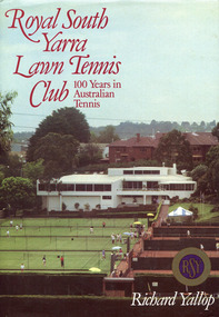
Book, Royal South Yarra Lawn Tennis Club: 100 Years in Australian Tennis, 1984
Royal South Yarra Lawn Tennis Club had its beginnings in the 1880s. The development of the club has been closely associated with the development of the game of tennis, with its changing styles of play. The Club has changed dramatically since its foundation in 1884. Tennis was a garden party pastime then and the clubhouse was a small wooden structure overlooking three asphalt courts. In the 1980s Royal South Yarra has been referred to as one of the best tennis clubs in the world. This history vividly recalls the early days of tennis and the tournaments and social events that enlivened the Club.xi, 148 p., [8] p. of col. plates : ill., facsims., ports. ; 27 cm.non-fictionRoyal South Yarra Lawn Tennis Club had its beginnings in the 1880s. The development of the club has been closely associated with the development of the game of tennis, with its changing styles of play. The Club has changed dramatically since its foundation in 1884. Tennis was a garden party pastime then and the clubhouse was a small wooden structure overlooking three asphalt courts. In the 1980s Royal South Yarra has been referred to as one of the best tennis clubs in the world. This history vividly recalls the early days of tennis and the tournaments and social events that enlivened the Club.royal south yarra lawn tennis club -- history, tennis clubs -- victoria -- south yarra -- history, richard yallop -
 Eltham District Historical Society Inc
Photograph, Gayle Blackwood, Le Gallienne House, 12 Yarra Braes Road, Eltham
Professor Downing - Dorian Le Gallienne House commenced construction in 1948. It was built by Horrie Judd, Les Punch, Wynn Roberts, Sonia Skipper and others. Designed by Alistair Knox. A fourth and final wing was added in 1964.29 colour prints 10 x 15 cm 1 A4 document of supporting sales literature and notesgayle blackwood collection, houses, mudbrick, morrison kleeman real estate, yarra braes road, eltham, le galienne house, alistair knox design -
 Kew Historical Society Inc
Photograph - Historic re-enactment during the Festival of Kew, 1978
At the 1978 Festival of Kew, a number of organisations, including the City of Kew, the Kew Historical Society, Trinity Boys Grammar School and local Girl Guides participated in a re-enactment of the expedition of the party of Charles Grimes in surveying the Yarra River as far as Kew in February 1803. The location for the event was Yarra Bend Park near the Studley Park Boat House. The event was organised by the Kew Historical Society. The re-enactment was captured by a number of amateur photographers as well as by a photographer from the local Progress Press.Local communities select events to commemorate according to their shared history and values. Commemorations of colonial exploration were popular with local historical groups such as the Kew Historical Society in the twentieth century. In re-enacting events such as the Grimes survey of the Yarra, students from a local school were encouraged to take on specific roles, including play-acting individuals involved in the survey party as well as members of the local Wurundjeri People. The photographs, taken by amateur and professional photographers, represent a period in time when the dominant values were those shared by the descendants of European settlers in Victoria. Original colour photographic positive showing a boy from Trinity Grammar School in a tree, role-playing Captain Robbins, a member of Grimes' survey party.Annotated on reverse: "CAPTAIN ROBBINS LOOKING UP THE YARRA AND REPORTING: 'A LAND THAT OFFERS GREAT OPPORTUNITY FOR SETTLEMENT' / RE-ENACTED BY A TRINITY BOY / 1978 FESTIVAL"kew historical society, trinity grammar school, kew girl guides, city of kew, yarra river, charles grimes, collins expedition, wurundjeri people, yarra bend park, colonial surveys, historic re-enactments, festival of kew, kew festival -
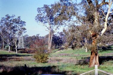 Greensborough Historical Society
Slide - Photograph, John Ramsdale, Near the confluence of the Plenty and Yarra Rivers, Lower Plenty: Slide 118, 1990s
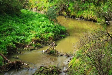
Photograph shows a rural scene with gumtrees and pylon. This is near the confluence of the Plenty and Yarra Rivers, Lower PlentyPart of the John Ramsdale collection of slides and audio visual material.Colour photograph scanned from slide.No maker's marks. No caption on slide.yarra river, plenty river, lower plenty -
 Greensborough Historical Society
Photograph - Digital Image, Plenty River Greensborough May 2014 -1, 21/05/2014
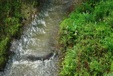
The Plenty River flows south from Mt Disappointment before meeting with the Yarra River at Rosanna. These images taken in the Greensborough area. Photograph by Marilyn Smith 2014.Digital copy of colour photograph.plenty river, greensborough -
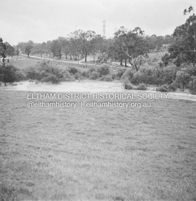 Eltham District Historical Society Inc
Album - Photograph, J.A. McDonald, Eltham-Yarra Glen Road, 18 Oct. 1956
Eltham-Yarra Glen Road Proposed crossing of Plenty River at Lower Plenty. Floods 18th October 1956.Record of various Shire of Eltham infrastructure works undertaken during the period of 1952-1962 involving bridge and road reconstruction projects, sometimes with Eltham Shire Council Project Reference numbers quoted. It was during this period that a number of significant improvements were made to roads and new bridges constructed within the shire that remain in place as of present day (2022). In many situations, the photos provide a tangible visible record of infrastructure that existed throughout the early days of the Shire. The album was put together by or under the direction of the Shire Engineer, J.A. McDonald.infrastructure, road construction, shire of eltham, bridge construction, eltham-yarra glen road, 1956-10-18, floods, floodwater, lower plenty, plenty river -
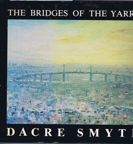 Greensborough Historical Society
Book, The Bridges of the Yarra: a book of paintings, poetry and prose, by Dacre Smyth, 1980_
Unpaged, dustjacket, colour illustrationsyarra river, bridges, dacre smyth, poetry, paintings -
 Melbourne Tram Museum
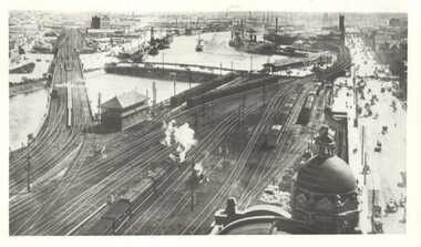
Photograph - Yarra River from Flinders St Station clock tower, Town and Country Journal, 1909
Photos show the Yarra river and the shipping turning basin that was used prior to the construction of the Spencer St bridge. In the view are are steam hauled suburban trains, Flinders St A signal box, Queensbridge, and the wharves on either side of the river. The viaduct was expanded to four tracks in 1915. Yields information about Yarra River, Flinders St railway station yards and shipping,Set of two photographs looking west from the Flinders St Station clocktower. over the Yarra River and station yards.On rear of both prints in ink: 1 – Melbourne - West from clock tower on Flinders St station - “Town and Country Journal 21/7/1909” Copy neg Mark Plummer collections ex late John Alfred collection. .2 - Melbourne, Looking west along Flinders St from clocktower of Flinders St station. Copy neg Mark Plummer collections ex late John Alfred collection. Has “T&C 20/12/09” in pencil on rear. bridges, flinders st station, yarra river, wharves, railways, signal boxes, queens bridge, shipping -
 Lakes Entrance Regional Historical Society (operating as Lakes Entrance History Centre & Museum)
Photograph, Rose Stereographers Armadale Victoria, 1920 - 30 c
The writer of the message on back of card was a Miss Ruth Catt who boarded with the family of Vic and Myrtle Fish of Roadknight St Lakes Entrance in the 1920 - 30 She was a teacher at the Bunga Creek State School East of Lakes Entrance and walked through the bush to schoolSepia toned postcard showing white wooden bridge over Yarra River with hill at back densely wooded shrubbery along river bank and rocky foreground at Warburton VictoriaThe Rose Series P3643 The Beautiful Yarra Warburton Victoriasocial history, fundraising -
 Upper Yarra Museum
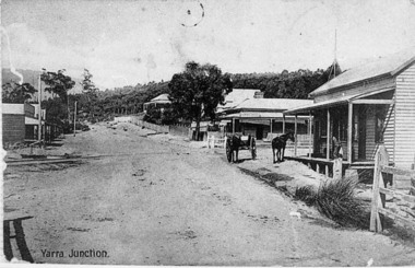
Negative Photographic Reproduction, Main St Yarra Junction
This intersection was a busy one with the tramway traffic having Steam Engines and their trucks crossing about 8 times a day, horsedrawn vehicles often had trouble crossing the tramway because it was quite uneven at times.03037 PC Main Street Yarra Junction, at the corner of Little Yarra Rd, the Powelltown tramway crosses the road at this intersection Upper Yarra Shire 1888-1988 Centenary collection. Negative, Black & white. Scanned at 600 dpi. yarra junction main street rail crossing -
 Power House Rowing Club
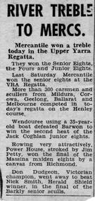
Newspaper clipping, RIVER TREBLE TO MERCS, 1958
RIVER TREBLE TO MERCS -
 Greensborough Historical Society
Photograph - Digital Image, Plenty River Greensborough, May 2014 -10, 21/05/2014
The Plenty River flows south from Mt Disappointment before meeting with the Yarra River at Rosanna. Early settlement in Greensborough was based around the Plenty River. These images were taken in the Greensborough area by Marilyn Smith May 2014.Digital copy of colour photograph.plenty river -
 Greensborough Historical Society
Photograph - Digital Image, Plenty River Greensborough, May 2014 -9, 21/05/2014
The Plenty River flows south from Mt Disappointment before meeting with the Yarra River at Rosanna. Early settlement in Greensborough was based around the Plenty River. These images were taken in the Greensborough area by Marilyn Smith May 2014.Digital copy of colour photograph.plenty river -
 Greensborough Historical Society
Photograph - Digital Image, Plenty River Greensborough, May 2014 -8, 18/09/2014
The Plenty River flows south from Mt Disappointment before meeting with the Yarra River at Rosanna. Early settlement in Greensborough was based around the Plenty River. These images were taken in the Greensborough area by Marilyn Smith Sept 2014.Digital copy of colour photograph.plenty river -
 Greensborough Historical Society
Photograph - Digital Image, Plenty River Greensborough, May 2014 -7, 21/05/2014
The Plenty River flows south from Mt Disappointment before meeting with the Yarra River at Rosanna. Early settlement in Greensborough was based around the Plenty River. These images were taken in the Greensborough area by Marilyn Smith May 2014.Digital copy of colour photograph.plenty river -
 Greensborough Historical Society
Photograph - Digital Image, Plenty River Greensborough, May 2014 -6, 21/05/2014
The Plenty River flows south from Mt Disappointment before meeting with the Yarra River at Rosanna. Early settlement in Greensborough was based around the Plenty River. These images were taken in the Greensborough area by Marilyn Smith May 2014.Digital copy of colour photograph.plenty river -
 Greensborough Historical Society
Photograph - Digital Image, Plenty River Greensborough, May 2014 -5, 21/05/2014
The Plenty River flows south from Mt Disappointment before meeting with the Yarra River at Rosanna. Early settlement in Greensborough was based around the Plenty River. These images were taken in the Greensborough area by Marilyn Smith May 2014.Digital copy of colour photograph.plenty river -
 Greensborough Historical Society
Photograph - Digital Image, Plenty River Greensborough, May 2014 -4, 21/05/2014
The Plenty River flows south from Mt Disappointment before meeting with the Yarra River at Rosanna. Early settlement in Greensborough was based around the Plenty River. These images were taken in the Greensborough area by Marilyn Smith May 2014.Digital copy of colour photograph.plenty river -
 Greensborough Historical Society
Photograph - Digital Image, Plenty River Greensborough, May 2014 -3, 21/05/2014
The Plenty River flows south from Mt Disappointment before meeting with the Yarra River at Rosanna. Early settlement in Greensborough was based around the Plenty River. These images were taken in the Greensborough area by Marilyn Smith May 2014.Digital copy of colour photograph.plenty river -
 Greensborough Historical Society
Photograph - Digital Image, Plenty River Greensborough, May 2014 -2, 21/05/2014
The Plenty River flows south from Mt Disappointment before meeting with the Yarra River at Rosanna. Early settlement in Greensborough was based around the Plenty River. These images were taken in the Greensborough area by Marilyn Smith May 2014.Digital copy of colour photograph.plenty river -
 Upper Yarra Museum
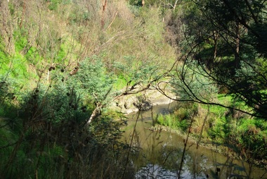
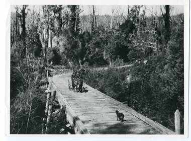
Negative Photographic Reproduction, Bridge over the Yarra
03050 Bridge over the Yarra. Upper Yarra Shire 1888-1988 Centenary collection. Black & white Negative, scanned at 600 dpibridge over yarra river -
 Orbost & District Historical Society
black and white photograph, 1913
This photograph is of the low level bridge across the Bemm River about 50 km east of Orbost in East Gippsland.This is a pictorial record of the 1913 low level bridge across the Bemm River, East Gippsland.A large black / white photograph of a horse - drawn wagon on the low level Bemm River bridge. In the foreground on the bridge is a dog.on back - "Country Roads Board Princes Highway low level bridge" -
 Kew Historical Society Inc
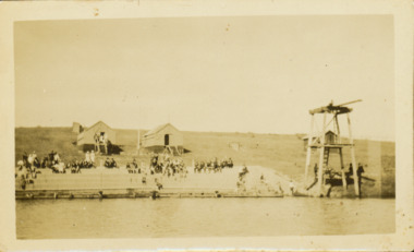
Photograph - Deep Rock Swimming Pool and Clubrooms on the Yarra, c.1925
The former Deep Rock Swimming Pool was about 500 yards [457 metres] above Dight’s Falls. It was there that the Deep Rock Swimming Club was established in 1906. This initial club was expanded in 1916 to incorporate a life-saving club. In 1918, John Wren, the president of the club offered the club £1000, and undertook to sponsor a patriotic carnival in March 1918, at which swimming champions would take part. The ‘pool’ was to achieve fame as the venue for a world record-breaking ‘swallow dive’ of 205 feet 9 inches [63 metres] by ‘Prince Wickyama’, [aka Alec Wickham], a Solomon Islander. The dive from a special platform on the west side of the Yarra was reputedly viewed by between 50,000-100,000 spectators, with funds going to the State War Council. The Herald, 25 March 1918, claimed that the wide area occupied by spectators made more precise estimates impossible. In the 1980s, the construction of the Eastern Freeway, and the consequent re-routing of the Yarra River led to the site of the Deep Rock Pool being obliterated. A small cairn and plaque on the Fairfield side of the river now marks its former site.Very rare early photograph off the Deep Rock swimming pool. The pool and its built structures are historically and socially important to the people of Collingwood, Fairfield and Kew. Small, faded, Gelatin Silver print positive photograph of the Deep Rock Swimming Pool situated on the Yarra at Collingwood and Fairfield. The famous diving tower is at the right of the photo. The built structures were constructed for the Deep Rock Swimming and Life Saving Club. People are sitting on the terraces above the river. "Bathing Club. Deep Rock on the Yarra. Studley Park Melbourne. Please credit E.J. Thomasson Collection"deep rock swimming pool, deep rock swimming club, deep rock lifesaving club, swimming -- river yarra, river yarra -
 Warrnambool and District Historical Society Inc.
Map - An Angler's map of the Hopkins River Estuary, Angler's map Hopkins River, 1980s
This is a map of the Hopkins River Estuary prepared by Dr John Sherwood for the benefit of anglers. The information on the sheet includes the location of sand banks, the water depths, boat ramp facilities and public access facilities. Some of the information has been gathered from aerial photographs. The map has been produced by the Warrnambool Institute of Advanced Education which was developed in the late 1960s from the tertiary section of the Warrnambool Technical College and with all its departments established by 1984 at the Sherwood Campus five kilometres from Warrnambool on the Princes Highway. Today the site is occupied by Deakin University, Warrnambool campus. The Warrnambool Anglers’ Club has its headquarters on the banks of the Hopkins River near the mouth of the river and the Lyndoch Aged Care facility.This map is of interest as a specialist one, providing fishermen with detailed information on all aspects of the Hopkins river estuary. Fishing has been both a profession and a popular recreational pursuit for Warrnambool residents since the early days of the city’s settlement. The Hopkins River Estuary has been a focal point for fishermen throughout Warrnambool’s history. This is a sheet of paper folded three times to produce a folded map. The front cover has a black and white photograph of two fishermen with a large fish. The map of the Hopkins River Estuary is in yellow, blue and black and covers the side of one sheet and three quarters of the other side. There is an advertisement for the Hopkins River Boathouse with a black and white sketch of the boathouse and notes on the map written by Dr John Sherwood. There are several diagrams showing the water depths. The map has some silverfish damage and some tearing at the folds. warrnambool anglers’ club, history of warrnambool, hopkins river, hopkins river estuary, john sherwood -
 Marysville & District Historical Society
Postcard (item) - Colour postcard, Nicholas John Caire, Scene Watt's River, Fernshaw, 1858-1918
One of a series of postcards of photographs taken by socialite photographer Nicholas John Caire. N.J. Caire had a great love for the area and in the late 1800's took many photographs of Marysville and its surrounds.One of a series of postcards of photographs taken by socialite photographer Nicholas John Caire. N.J. Caire had a great love for the area in and surrounding Marysville and in the late 1800's took many photographs of Marysville and its surrounds. N.J. Caire was born in 1837 in Guernsey. He arrived in Adelaide about 1860 along with his parents who encouraged his early interest in photography. He opened a studio in Adelaide in 1867 after traveling extensively throughout the Gippsland taking photographs. After marrying in 1870 he moved to Talbot in Victoria until 1876 when he opened a studio in the Royal Arcade in Melbourne. After 1885 N.J. Caire gave up his city work and made his home in South Yarra and devoted the rest of his life to outdoor photography, specializing in the bush, the gullies and the mountains of south-eastern Victoria. POST CARD This Space may be used for Correspondence (FOR ADDRESS ONLY) Orange one penny postage stamp with an image depicting Queen Victoria Date stamp/ 8.3.06/ 4AM/ MELBOURNE/ 14 7.3.06 My Dear Em/ I received your kind/ note and will be very pleased/ to go out & see you tomorrow/ but cannot say what/ train I will catch as/ I do not know how/ they run. I will try/ not to miss the train/ though. I heard Vic was/ down will be glad to see/ her love to you both/ Yours in health Mary. Mrs Tribeau/ "Hazel Dell"/ Connell Street/ Hawthornwatt's river, fernshaw, victoria, nicholas john caire, postcard, souvenir