Showing 127096 items
matching main-road
-
 Ringwood and District Historical Society
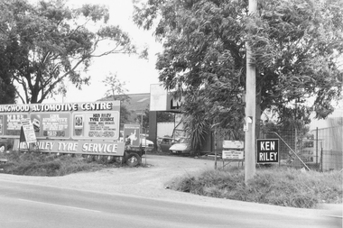
Photograph, Ringwood Auto Service, Oban Road, Ringwood owned by Ken Riley
Written on back of photograph, "E624. N17. 1981. No.7 Oban Road. Ringwood Auto Service - Ken Riley". -
 Ringwood and District Historical Society
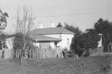
Photograph, Ringwood's first Police Station, 32 Mount Dandenong Road. (note room at left)
Written on back of photograph, "32 Mount Dandenong Road. Ringwood's first Police Station (note room at left). -
 Ringwood and District Historical Society
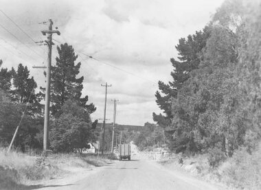
Photograph, Heatherdale Road rail crossing looking south from Maroondah Highway c.1924
Typed below photograph, "Heatherdale Road railway crossing. Looking south from Maroondah Highway c.1949. -
 Ringwood and District Historical Society
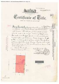
Document, Certificate of Title - Mary Burchett, Lilydale Road, Ringwood - part of Crown Section 20, Parish of Warrandyte, County of Evelyn - 14th January, 1910
A4 copies of Landata Victoria Historical Search documents - Vol 3398 Fol 679415.Mary Burchett of Lilydale Road, Ringwood, Married Woman, is now the proprietor of an Estate in Fee-simple subject to the Encumbrances notified hereunder ... 55 acres 3 roods 35 perches or thereabouts, being lots 8 and 9 on plan of subdivision no.4315. Subdivision map includes un-named road - Grandview Grove (later Bemboka Road, Warranwood, Vic). Title transferred to Theodore Hartley Burchett, 27th July, 1911. -
 Southern Sherbrooke Historical Society Inc.
Postcard - Postcard-original-Swans Bend Belgrave, Vic. c.1940s, A Bend In The Road, Belgrave
Sepia-toned postcard featuring bend coming into Belgrave Township from the west. Later known as Swans Corner. Dr Shirley Francis's house in centre of photo. Photo shows a hillside with three houses above the road. A man walks along the lower side of the road. c. 1920s. -
 Marysville & District Historical Society
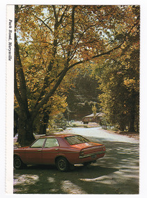
Photograph (Item) - Colour photograph, Unknown
A colour photograph taken of the view looking down Pack Road towards Murchison Street in Marysville in Victoria.A colour photograph taken of the view looking down Pack Road towards Murchison Street in Marysville in Victoria.pack road, marysville, victoria, photograph, murchison street -
 Marysville & District Historical Society
Photograph (Item) - Colour photograph, Travel Victoria, 2004
A colour photograph of the view looking up Pack Road from the corner with Murchison Street in Marysville in Victoria.A colour photograph of the view looking up Pack Road from the corner with Murchison Street in Marysville in Victoria.pack road, murchison street, marysville, victoria, travel victoria, photograph -
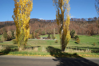 Marysville & District Historical Society
Photograph (Item) - Colour photograph, Unknown
A digital copy of a colour photograph taken of a house along the Marysville-Buxton Road near Marysville in Victoria.A digital copy of a colour photograph taken of a house along the Marysville-Buxton Road near Marysville in Victoria.marysville-buxton road, marysville, buxton, victoria, photograph -
 Melbourne Tram Museum
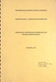
Document - Report, John Knee, "Warragul Road - Toorak Road Intersection", Jan. 1977
Report - "proposed East Burwood Tramway Extension - Warragul Road - Toorak Road Intersection - Preliminary Appreciation intersection and shopping redevelopment - Jan. 1977". Prepared by John W Knee for the MMTB and others. Looks at the intersection, how the shopping centre could be accessed, possible Mall development, residential issues, passenger facilities and pedestrian capacity. Includes a number of possible access routes for the area. None were applied when the tram line was extended.Yields information about a consideration for the extension of the Toorak Road line to East Burwood in 1977.Comb bound report with clear plastic covers, brown covers, 17 A4 pagesmmtb, east burwood, toorak road, warragul road, new tramways, john knee -
 Melbourne Tram Museum
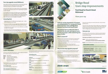
Pamphlet, VicRoads, "Bridge Road tram stop improvements", Sep. 2011
Pamphlet, printed on cream recycled paper, A3 + and A4 tear off titled "Bridge Road tram stop improvements". giving details of the Punt Road to Church St section of Bridge Road tram line. Installation of two level access tram stops to replace the existing three - Vienna style. Has details on the proposal, the background reasons, inviting people to have their say, information sessions, maps, diagrams and contact details and survey form. 2 copies held.trams, tramways, bridge rd, tram stops, vienna style stops, vicroads, disability services -
 Melbourne Tram Museum
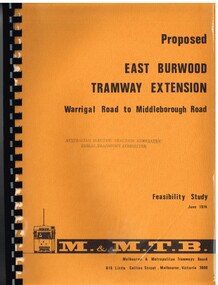
Document - Report, Melbourne & Metropolitan Tramways Board (MMTB), "Proposed East Burwood Tramway Extension - Warragul Road to Middleborough Road - Feasibility Study, Sep. 1974
Report - 68 pages, photocopied onto light cartridge paper with brown covers both sides, overlain with clear plastic covers and black comb bound. Titled "Proposed East Burwood Tramway Extension - Warragul Road to Middleborough Road - Feasibility Study June 1974", looks at the purpose of the extension, possible patronage, construction details, costs, existing services and impact on these, proposed services, operating costs, revenue and social benefit - cost analysis. Has many tables, diagrams including fold out map. Showed that the benefit outweighed the costs of the project. Prepared by the MMTB June 1974 - report on front page notes it is Amendment A, September 1974.Stamped "Australian Electric Traction Association Public Transport Committee" on both cover and inside front page.trams, tramways, burwood, east burwood, feasibility study, new tramway, mmtb, middleborough rd -
 Surrey Hills Historical Society Collection
Folder of information, Libby Cavenagh's 1990 building census of Wandsworth Road, Surrey Hills, 1990
Libby Cavenagh was Secretary of the Surrey Hills Historical Society. She completed this study as part of a Diploma of Local History she was undertaking at the University of New England. At the time she lived in Wandsworth Road.This is a unique analysis of the housing stock of a complete street at one point in time. Many of the houses have been altered since the study was completed and quite a number have been demolished.Blue folder of A4 size. This contains an analysis of each house in Wandsworth Road in 1990 with details regarding building style, approximate age, materials used, fence design, presence or absence of a garage or carport and some comment on the garden elements. For most entries there is a coloured photo taken from the street. For some there are photocopies of real estate advertisements. There are a number of appendices including s a map of the breakdown of styles and materials; date of construction and other information from the Camberwell Building registers 1890-1934; entries re owners from Sands & McDougall directories, 1897-1937; map from Land Titles Office showing sub-division information; land auction advertisements; information re W J Vine; list of builders; references.wandsworth road, libby cavenagh -
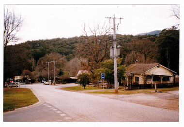
 Marysville & District Historical Society
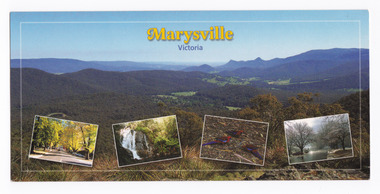
Postcard (item) - Colour postcard, Imagine That! Promotions, Marysville-Victoria, 2002
A colour photograph of the view from Keppel Lookout of Marysville and the Cathedral Range along with photographs of the main street in Marysville, Steavenson Falls, birdlife and snow in Marysville. A colour photograph of the view from Keppel Lookout of Marysville and the Cathedral Range along with photographs of the main street in Marysville, Steavenson Falls, birdlife and snow in Marysville. This postcard was produced by Imagine That! Promotions as a souvenir of Marysville.Marysville is a beautiful small country town approximately 100 km's from Melbourne. It is/ well known for its amazing autumn colours, prolific wildlife and is only half an hours drive/ from Lake Mountain, Australia's largest Cross Country Skiing Resort./ Featured is (Main Picture) Marysville with the picturesque Cathedral Range in the back-/ ground as seen from Keppel Lookout. From the left is Marysville's main street during/ Autumn, Steavenson Falls, Crimson Rosellas and Marysville covered by a low snowfall. Imagine That!/ Post Cards Imagine That! Promotions/ Country Victoria Collection/ Landscape 1/ c 2002/ Ph: (03) 5966 8523 Fax: (03) 5966 8458 Mob: 0418 593 534 Place/ Stamp/ Heremarysville, keppel lookout, cathedral range, murchison street, steavenson falls, scarlet rosella, snow, imagine that! promotions, postcard, souvenir -
 Whitehorse Historical Society Inc.
Photograph - Black and white photograph, Burwood Road, East Burwood, c1950
Black and white photograph of an ice cart on Burwood Road, East Burwood and on the north side the business of W.Smith & Son.|The occupants of the properties from the corner of Middleborough and Burwood Roads - north side were in 1923 (Sands & McDougall) Woolard, Bennett,Christensen and Fullton. Royton Street W. Smith & sonburwood road, burwood east, woolard, bennett, christensen, fullton., royton street burwood east, w. smith & son -
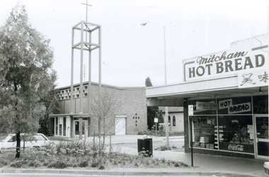 Whitehorse Historical Society Inc.
Photograph, Corner Edward Street & Whitehorse Road, Mitcham, 2000
Produced as one of a series of 24 prints commissioned by Nunawading & District Historical Society -|Theme: Intersections of Mitcham and Nunawading 2000/2001.|See also Series by P. Simmenauer on the same theme.Black and white photograph - print and negative of Corner of Edward Street & Whitehorse Road looking North West, from L-R: Anglican Church of Christ; Church Hall in weatherboard. In streetscape (Whitehorse Road) Mitcham Hot Bread Kitchen, Coca Cola Sign and Chinese calligraphy on shop sign.christ church anglican church, mitcham, mitcham hot bread shop, edward street -
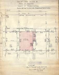 Ringwood and District Historical Society
Document, 1926 Land Survey drawing of the area surrounding 1-5 City Road, Ringwood
Drawing on parchmentHand-drawn survey of what is now 1-5 City Road, Ringwood. Drawn by K Arndt, licensed surveyor, 237 Queen Street, Melbourne Tel 5118 on 25 September 1926. The block of land in question was 2 roods, 21 and 8/10 perches in size. The location was between Haig Street in the north, City Road in the south, Wantirna Road in the west and Victoria Road in the east. The Good Shepherd Retirement Village (Lutheran) now occupies the land. The drawing shows a number of existing weatherboard houses, fences and frontage sizes. A number of named roads were defined but no longer exist, these were Duffy Street (to the west), Evans Street (east) and Victoria Street (further east). Ireland Street still exists in the south. -
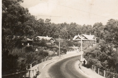
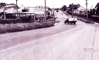
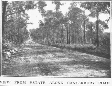 Ringwood and District Historical Society
Photograph, Coleman's Heathmont Estate Sale, 15/12/1923. Looking west along Canterbury Road Heathmont. Railway bridge is situated at foot of hill
Printing below photograph reads, "View from estate along Canterbury Road." Typed on backing sheet below, "Canterbury Rd. Heathmont looking towards city. Railway bridge at foot of hill 1923. Area in foreground now shopping centre both sides of road." -
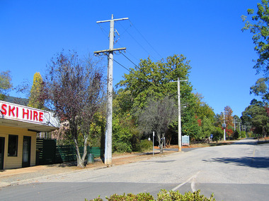
 Marysville & District Historical Society
Postcard (item) - Colour postcard, K. & H. Ellis, Pack Road, Marysville, Pre 2009
A colour photograph of Murchison Street in Marysville in Victoria.A colour photograph of Pack Road in Marysville in Victoria. Labeling is incorrect. View is down Murchison Street towards Barton Bridge. In the background can be seen the rectory from the Church of England. The rectory survived the 2009 Black Saturday bushfires whilst the church was destroyed. This postcard was produced by Colorscans Publishing as a souvenir of Marysville.Colorscans c PUBLISHED & PRINTED BY COLORSCANS (PUBLISHING) PTY LTD 118-120 BRIGHTON STREET, RICHMOND 3121/ Supa-vu/ cards MARYSVILLE - VICTORIA/ Pack Road, Marysville Photographed and Distributed by:/ K & H. Ellis - 35 Old Warburton Road,/ Warburton 3799marysville, victoria, pack road, murchison street, postcard, souvenir, colorscans publishing, k & h ellis, 2009 black saturday bushfires, church of england -
 Rutherglen Historical Society
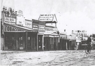
Image, 1900 Approximate
Donated by Mr Greg Thomson, a former resident of RutherglenBlack & white reproduction, printed on paper. This photograph is of Main St Rutherglen facing West. In centre of photograph is the Rutherglen Hotel. Further down the street, at the right of the photo is the striped roof of the Cumberland Hotel.On back of photo: "Main St Rutherglen - facing west"main street, rutherglen hotel, cumberland hotel -
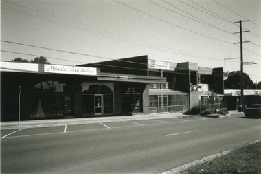
 Ringwood and District Historical Society
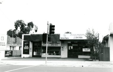
Photograph, Wantirna Road Shops, Ringwood, Victoria - 1993, 28-Feb-93
Black and white photograph of group of shops in Wantirna Road Ringwood including McPhail Hardware and Wantirna TV and Video Service. -
 Lorne Historical Society
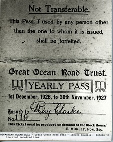
Photograph, Great Ocean Road Yearly Travel Pass
Dated 1 December 1926 to 30 November 1927. G.O.R. Trust, Yearly PassPhoto of Annual Yearly Pass. Dated 1st December 1926 to 30th November 1927. Donors to Road received them.great ocean road. trust. yearly travel pass -
 Ringwood and District Historical Society
Photograph-B&W, Joan Walker, East Ringwood 2000-Shops in Railway Avenue (Dublin Road end), 2000
East Ringwood 2000-Shops in Railway Avenue (Dublin Road end)- B&W Photo from Album 6501 -
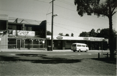 Ringwood and District Historical Society
Photograph-B&W, Joan Walker, East Ringwood 2000-Shops in Railway Avenue (Dublin Road end), 2000
East Ringwood 2000-Shops in Railway Avenue (Dublin Road end)- B&W Photo from Album 6501 -
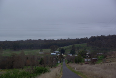 Victorian Interpretive Projects Inc.
Photograph - Colour, Clare Gervasoni, View from Nevin's Road towards the Swiss Italian Enclave at Yandoit Creek, 2014, 12/2013
For a 2004 comparative view see http://victoriancollections.net.au/items/52fdd83d2162ef1820380448 Two colour photographs showing the view from Nevin's Road towards the Swiss Italian Enclave at Yandoit Creek, 2014yandoit, yandoit creek, yandoit hill, gervasoni, drystone, swiis/italian -
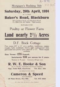 Whitehorse Historical Society Inc.
Document, Baker's Road
advertising pamphlet for sale of 2.5 acresReal Estate Agent's advertising pamphlet for sale of 2.5 acres of land in Baker's Road, Blackburn on 28/4/1934 advertising pamphlet for sale of 2.5 acres bakers road, blackburn, real estate -
Whitehorse Historical Society Inc.
Map, Mitcham Road, c1970
Enlarged aerial photo of the intersection of Mitcham and East Doncaster Roads, Mitcham. Scale 1 inch : 40 feet.Enlarged aerial photo, c1970, of the intersection of Mitcham and East Doncaster Roads, Mitcham. Scale 1 inch : 40 feet.Enlarged aerial photo of the intersection of Mitcham and East Doncaster Roads, Mitcham. Scale 1 inch : 40 feet.mitcham road, mitcham, quarry road, mitcham, doncaster east road, mitcham, wooddale grove, mitcham, mitcham primary school, no. 2904, aerial photographs -
Whitehorse Historical Society Inc.
Pamphlet, The Road closure issue in Blackburn, 1975
City of Nunawading report featuring a Task Force finding and the formation of the Blackburn Residents Road Closure Protest Group in 1975City of Nunawading report featuring a Task Force finding and the formation of the Blackburn Residents Road Closure Protest Group in 1975City of Nunawading report featuring a Task Force finding and the formation of the Blackburn Residents Road Closure Protest Group in 1975roads and streets, city of nunawading, blackburn residents road closure protest group, naughton grove, blackburn, jeffery street, blackburn, alandale road, blackburn, wellington avenue, blackburn, gordon crescent, blackburn, blackburn road, blackburn, wolseley crescent, blackburn, mckinnon street, blackburn, forest road, blackburn -
Whitehorse Historical Society Inc.
Pamphlet, Burke & hills: Canterbury Road, 2014
A pictorial publication of Canterbury Road from Camberwell to Montrose, past and present.A pictorial publication of Canterbury Road from Camberwell to Montrose, past and present. Gerry Robinson, Convenor of Heathmont History Group.A pictorial publication of Canterbury Road from Camberwell to Montrose, past and present. canterbury road, robinson, gerry -
 Whitehorse Historical Society Inc.
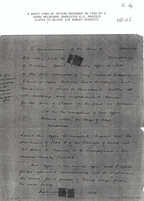
Letter - Correspondence, Orchard Mitcham Road, 1/09/1928
Draft form of an option prepared in 1928 by Melbourne barrister R.G. MenziesPhotocopy of draft form of an option prepared in 1928 by Melbourne barrister R.G. Menzies for the sale of an orchard in Mitcham Road, Mitcham.Draft form of an option prepared in 1928 by Melbourne barrister R.G. Menziesorchards, land sales, menzies, robert gordon, sir, mitcham road, mitcham -
 Whitehorse Historical Society Inc.
Photograph, Whitehorse Road Mitcham, 1/11/2000 12:00:00 AM
Coloured photograph of Mitcham Road looking south from near Milne Street Mitcham showing garages and industrial shops.whitehorse, road mitcham, milne street, mitcham