Showing 27535 items
matching yarra-river
-
 Echuca Historical Society
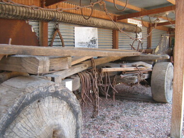
Log Buggy
1860's Log Buggy used to move logs from forests to river for transportation to sawmillsLarge wooden wheeled trailer - log buggy -
 Lakes Entrance Regional Historical Society (operating as Lakes Entrance History Centre & Museum)
Postcard, 1920c
Ensay Hotel now known as Little River Inn at 64-70 Johnson St EnsayBlack and white postcard of a view of the Ensay Hotelagriculture, buildings -
 Rutherglen Historical Society
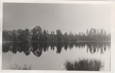
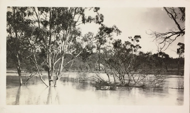
Image, c1870
Possibly Lake King shortly after the weir was built, or Lake Moodemere or the Murray River in flood.Black and white photograph of a body of water surrounded by trees.lake king, lake moodemere, murray river -
 Bendigo Historical Society Inc.
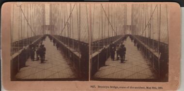
Photograph - HARRIS COLLECTION: STEREOSCOPIC VIEWS, Nineteenth Centur
Stereoscopic views. Kilburn Brothers Littleton , N H. 1. Trinity college Dublin. 2. Brooklyn Bridge, scene of the accident , May 30th 1883. 3. Spinning Room , Mechanics Mill, Fall River Mass. 4. Bay Grove Hill, Greenwood Cemetery, Brooklyn, N Y. 5.Crossing the Great Suspension Bridge, by rail. 6. Dining Hall , Grand Union Hotel, Saratoga, Largest Dining Hall in the World. 7. Phantom Leaves. 8. Full Moon. 9. Merced River, Yo-Semite , Cal. 10. I Breathe Inspiration. 11. United States Hotel Park, Saratoga.Kilburn Brothers Littleton N H.photography, viewers -
 Bendigo Historical Society Inc.
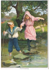
Document - MALONE COLLECTION: GREETING CARDS, 15/1/1910
Coloured picture of a boy wearing a blue & white sailor suit paddling across a stream. He is holding a girl's hand as she walks over the stepping stones in the stream. She is wearing a pink dress & hat and black stockings & shoes. The boy has a pole in his hand. On the bank of the stream is a large tree and some grazing sheep. At the back is a grey building. The picture is mounted on cardboard. 'Horner's Magazine, River of Life Series, MP274, MP275, MP276, & MP277 is written in pen on the back. The picture is titled 'Playmates'. At the top of the picture is printed 'zhorner's Penny Stories 'River of Life' Series No 1. 15.1.1910.personal effects, greeting cards, malone collection, malone collection, greeting cards, horner's magazine river of life series -
 Wodonga & District Historical Society Inc
Album - Hume Reservoir Australia Album - Excavations for foundations inside coffer dam, January 1927, 1927
This set of photos is from a leather bound album bearing the inscription "HUME RESERVOIR AUSTRALIA" plus 'The Rt. Hon. L. C. M. S. Amery, P. C., M .P.' all inscribed in gold. It was presented to The Rt. Hon. L. C. M. S. Amery, P. C., M. P, Secretary of State for Dominion Affairs on the occasion of his visit to the Hume Reservoir on 2nd November 1927. This album is of local and national significance as it documents the planning and development of the Hume Reservoir up to 1927. It was the largest water reservoir in the British Empire. The album records the pioneering engineering work that went into its construction.DEPARTMENT OF PUBLIC WORKS, N.S.W. RIVER MURRAY WATERS SCHEME. HUME RESERVOIR. 21. Excavations for foundations inside coffer dam. New South Wales. January 1927. Cofferdams are temporary structures used where construction is being carried out in areas submerged in water. They are most commonly used to facilitate the construction or repair of dams, piers and bridges. To divert the river, a Coffer Dam was built across the old bed above and below the Dam site and tying into the end of the concrete wall built inside the levee bank. This completely surrounded the remainder of the site of the Dam and south wing wall, including an area of 12½ acres. hume reservoir australia, river murray waters scheme, hume reservoir construction, coffer dam -
 Orbost & District Historical Society
black and white photograph, before 1921
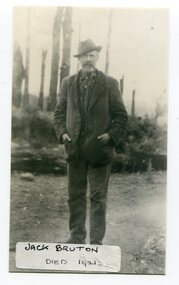
Jack Bruton selected land at Murrungowar and held the licence for the Murrungowar Hotel. He later became a butcher in Orbost. He was on the first Orbost Golf Club committee in 1906. .The golf club was established in 1906 it was originally formed as the Snowy River Golf Club and played on private land near the banks of the Snowy River just to the south of town.This is a pictorial record of Jack Bruton, one of the early settlers of Murrungowar, a former township east of Orbost.A black / white photograph of a man standing outside alone with his hands in his pocket. He has a moustache and has a pipe in his mouth. He is wearing a hat.on front - "Jack Bruton died 1921" on back - "Mr Jack Bruton, Murrungower Hotel"bruton-jack murrungowar-hotel orbost-golf-club -
 Warrnambool and District Historical Society Inc.
Book, George Rolfe's Book of Abstracts, Circa 1865
Alphabetical entries about many topics from fruit trees to Legislation, to Senate of America George Rolfe came to Warrnambool in 1872 and by 1883 was well established on the banks of the Hopkins River at Lyndoch. In 1884 he purchased Shipley which also had frontage to the Hopkins River. He participated in the social and sporting life of Warrnambool and was a keen rower.An interesting collection of thoughts and life of one of the early merchants and farmers of the area. He was a generous benefactor of the hospital.Dark green hard cover with maroon spine and corners. Pages are lined and alphabetical. Hand written entries throughout. : Inside front cover is label ”Cook & Fox, Account Book Manufacturers, Stationers, Bookbinders machine Rulers, Importers 58 Queen St Melbourne. Handwritten on front page “G Rolfe Senr. Book for extracts 1865. warrnambool, george rolfe, lyndoch, book for extracts -
 Greensborough Historical Society
Photograph - Digital image, Frank Robinson, Greensborough from Pope's paddock, 1956_
Greensborough from Pope's paddock. Pope's paddock was across the Plenty River from Blackjack. The Blackjack property, house and acres of fruit orchards ran down to the Plenty River off Hume Street Greensborough and was the home of the Robinson family to late 1956. The photographs were taken as slides by Frank Robinson and digitised by his son James in 2015.Digital copy of colour photograph.blackjack, robinson family, popes paddock -
 Eltham District Historical Society Inc
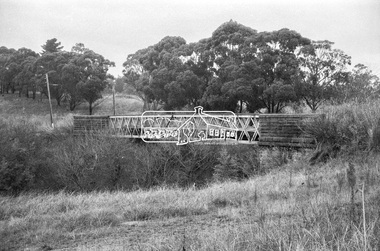
Photograph, Old Lower Plenty Bridge, c.1970
Old bridge across the Plenty River at Lower Plenty now part of the Plenty River Trail. Part of a slide show presentation "Bridges & Waterways of the Shire" by Russell Yeoman to the 13 September 1989 Society meeting. The presentation included slides of historic photos from the Shire of Eltham Pioneers collections as well as several recent views.Black and white photographmain road, plenty river, bridge, lower plenty, plenty river trail -
 Eltham District Historical Society Inc
Negative - Photograph, Russell Yeoman, Old Lower Plenty Bridge, c.1970
Old bridge across the Plenty River at Lower Plenty now part of the Plenty River Trail. Part of a slide show presentation "Bridges & Waterways of the Shire" by Russell Yeoman to the 13 September 1989 Society meeting. The presentation included slides of historic photos from the Shire of Eltham Pioneers collections as well as several recent views.Roll of 35mm black and white negative film, 4 of 7 stripsIlford HP4bridge, lower plenty, main road, plenty river, plenty river trail -
 Kiewa Valley Historical Society
Calendar 2008
Brief history of the SECV construction town of Bogong which became a tourist town."Memories of Bogong Calendar 2008" Photographs of the physical environment. Front cover has a photograph of a person standing in a river. A short history of 'Bogong 1957-1963' and 'Come visit Bogong Village' a 'celebration of Bogong Village's environment'. 12pp with a hole (to hang up) in the centre bottombogong, calendar, tourism, bogong village, secv, kiewa hydro electric scheme -
 Bendigo Historical Society Inc.
Document - STATE RIVERS AND WATER SUPPLY COMMISSION : EPPALOCK PROJECT - CONSTRUCTION
State Rivers and Water Supply Commission headed six page document, stapled. Subtitled: ' Eppalock Project - Construction. Some Technical Notes.' Information typed under subheadings: Dam, Embankment, Spillways, Outlet works, proposed hydraulic driven pumps, road deviations. Undated.state infrastructure, water supply, coliban system, state rivers and water supply commission. coliban system. eppalock. -
National Vietnam Veterans Museum (NVVM)
Document, Safe Conduct Pass
Deep yellow in colour with black print. Six flags (USA, Australia, Thailand, Korea, New Zealand and Philippines) on either side of South Vietnames flag. All other pages are B&W except the last page which has a river scene and pink flower.GIAY THONG-HANH "Safe conduct pass to be honored by all Vietnamese Government Agencies and Allied Forces" / Back signed by Nguyen Van Thienpermissive orders, pass, safe conduct -
Port Melbourne Historical & Preservation Society
Map - Photographic copy, Unidentified map of Sandridge, c. 1866
Photographic copy of an unidentified (Cox?) Sandridge map 1866 or later, with portions of West Melbourne, Emerald Hill and the Bend. Indicates bay and river soundings 'taken by Commander COX in 1866'. Original appears to have been torn and repaired; resultant lines whited out on copy.Fold lines have been whited out on back; '52'piers and wharves, transport - railways, built environment, maritime, beacons, sandridge lagoon, batteries - defensive, commander cox -
Bendigo Historical Society Inc.
Document - LAKE EPPALOCK OPENING CEREMONY PROGRAM 1964
Cream folded program. On front 'Lake Eppalock, Friday 17th April, 1964, printed in brown text. Inside : State Rivers and Water Supply Commission, Ceremony to mark the completion of the Eppalock Dam and Pumping Station and the Eppalock-Bendigo Pipeline, Friday 17th April, 1964.bendigo, waterworks, lake eppalock -
 Bendigo Historical Society Inc.
Document - Various writings by John Ellison
Writings on various topics. Some are glued inside a notebook. Two others are on loose pages. The notebook has a view of a lake/river with several small villages on the banks. location unknown. Topics are: "The Australian Aboriginals", ' The Great Pastland Movement", Problem of Urban Planning" and "the Plea of Youth".On the cover and on the first page a stamp: L.J. Ellison A.I.M.A.australian aborigines, pastoralist movement, urban planning -
Unions Ballarat
In step with Sturt (Don Woodward Collection), Swan, Keith et al, 1979
The book, targeted at school students, covers the years of Sturt's three expeditions. The authors question Sturt's capability as a surveyor and his leadership.Australian history.Graphic book; 115 pages. Dustjacket: plastic covering; brown and white background; black and white map of Sturt's journey along Murrumbidgee and the Murray River; black, gold and white lettering; authors' names and title. Cover: white and black lettering; authors' names and title.btlc, ballarat trades and labour council, ballarat trades hall, sturt, charles, history - australia, australia - explorers -
 8th/13th Victorian Mounted Rifles Regimental Collection
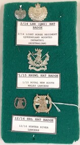
Badge - LH regimental badges
Five metal badges mounted on green fabric board : 2/14 Queensland Mounted Infantry (QMI) hat and lapel ; 1/15 Royal New South Wales Lancers (RNSWL) hat badge ; 12/16 Hunter River Lancers (HRL) hat and lapel.light horse, new south wales, lancers -
 Kew Historical Society Inc
Photograph - Flood, Zig-Zag, Kew, 1924
Henry Beater Christian (1886-1962) , was a descendant of one of the earliest settler families in Kew. Employed at the Kew Asylum as a 'public servant', he was a skilled amateur photographer, photographing numerous scenes in Kew and on his travels around Victoria. The majority of his photographs date from 1916 to 1929. His finest photographs are housed in two photograph albums. Digital copy of a photograph from page 5 of the 47-page photograph album containing 261 gelatinous silver images, loaned by Diane Washfold with permission given to digitise and hold a copy in our collection. This is a photograph of a section of the river at Kew during a flood in January 1924."Flood / Zig-Zag Kew / 1.24"henry beater christian (1886-1962), landscape photography, kew (vic.) — yarra river, christian-washfold collection, photograph albums, floods -- yarra river -- kew (vic.) -
 8th/13th Victorian Mounted Rifles Regimental Collection
Photograph
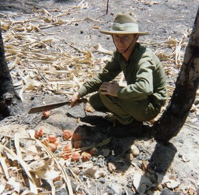
In 1988, as part of a Defence of Mainland Australian policy, defence of facilities of strategic importance in northern Australia were allocated to Army Reserve units. ‘A’ Squadron was allocated the defence of Tindal Air Force base located 15 KM outside Katherine in Northern Territory. Consequently the Squadron deployed on Exercise ‘Northern Explorer’ to gain first-hand knowledge of operating conditions for mounted and dismounted patrolling in the area.Lance Corporal R. Van De Velde, ' A ' Squadron 8/13 VMR during Exercise ' Northern Explorer' September 1988. LCpl Van De Velde has a collection of Pandamus Palm nut prematurely ripened by fire near King River Northern Territory. -
 8th/13th Victorian Mounted Rifles Regimental Collection
Photograph
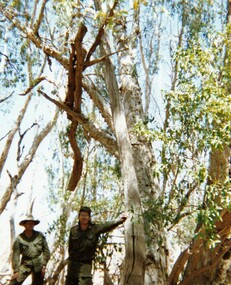
In 1988, as part of a Defence of Mainland Australian policy, defence of facilities of strategic importance in northern Australia were allocated to Army Reserve units. ‘A’ Squadron was allocated the defence of Tindal Air Force base located 15 KM outside Katherine in Northern Territory. Consequently the Squadron deployed on Exercise ‘Northern Explorer’ to gain first-hand knowledge of operating conditions for mounted and dismounted patrolling in the area.Colour photograph of Captain C. Carrington, earing hat, and Sergeant Koschel of ' A ' Squadron 8/13 VMR during Exercise " Northern Explorer." Flood debris caught high in tree branches indicate water level during wet season on Ferguson River, Northern Territory. -
![Hand-Drawn Map Centred on Myrtleford by Frank Lebbell Frost [ca 1915-1918]](/media/collectors/51d110e42162ef12e06aa06b/items/51fb0bb72162ef156c79aeee/item-media/52a11c442162ef1f0c9c052b/item-fit-380x285.jpg) Beechworth Honey Archive
Beechworth Honey ArchiveHand-Drawn Map Centred on Myrtleford by Frank Lebbell Frost [ca 1915-1918]
This is one of the maps drawn by Frank L. Frost while he was beekeeping in North-East Victoria. This particular map may be reference in the "Wooden" Diary on page 8.Hand-drawn map centred on Myrtleford, Palmerston, Gapstead Road, the Ovens River and the Myrtleford-Wangaratta Road. Shows locations of flowering eucalypts. Scale is 1 mile to 1 inch. Drawn with black pen and grey lead on paper. Names of towns are marked in red pen. hand drawn, hand-drawn, map, myrtleford, palmerston, gapstead, ovens, beekeeping, frost, beechworth honey -
 Melbourne Tram Museum
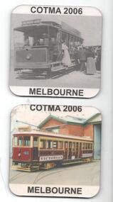
Domestic object - Coaster set, Council of Tramway Museums of Australasia (COTMA), 2006
Set of two drink Coasters, featuring a tramcar image printed onto a foam rubber backing. Tramcars featured are VR St Kilda Brighton tramcar VR41 and NMETL No. 13 at the Saltwater River terminus. Made by the Council of Tramway Museums of Australia for the Melbourne 2006 Conference.trams, tramways, cotma, vr trams, nmetl, souvenirs, tram 41, tram 13 -
 Melbourne Tram Museum
Negative, Wal Jack, 1943-44
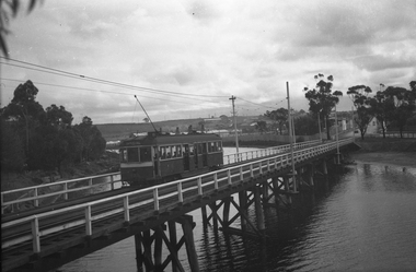
Black and white negative, by Wal Jack, of W5 832, showing Special B, crossing the Maribyrnong River Bridge westbound with a number of passengers. The tram only bridge has been duplicated during September 1943. Photo not dated in the Wal Jack album, c1943 - 44trams, tramways, w5 class, special b, maribyrnong river bridge, maribyrnong rd, world war 2, tram 832 -
 Melbourne Tram Museum
Negative, Possibly Keith Kings, c1960
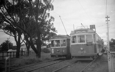
Black and white negative, by X1 461 and W7 1028 at the western end of Maribyrnong River bridge while on a AETA tour, Fri 31.3.1961. Date from railtourist.com.au VR Tours wiki. Following 1028 is a route 82 car. Photo not in Wal Jack Melbourne album.trams, tramways, maribyrnong river bridge, w7 class, x1 class, aeta, tram 1028, tram 461 -
 Eltham District Historical Society Inc
Photograph, The Leader, The "Black Swan" Mine and "The Old Dam", Warrandyte Gold Fields, 1897
Reproduced from "The Leader" 14th Aug. 1897, page 7 The "Black Swan" mine - on Captain Selby's property of 200 acres. Discovered by Captain Selby 8 years ago. He is working it himself. 'The shaft is down 70 feet and with deeper sinking the reef is found to increase in width. Nearly £2,000 has been obtained from this mine, the gold being of high quality, fetching £4-1-6 per oz.' Warrandyte photo "The Old Dam" - erected accross the river by Mr John Wallace, M.L.C., who attempted to turn the river and to work the river bed.This photo forms part of a collection of photographs gathered by the Shire of Eltham for their centenary project book,"Pioneers and Painters: 100 years of the Shire of Eltham" by Alan Marshall (1971). The collection of over 500 images is held in partnership between Eltham District Historical Society and Yarra Plenty Regional Library (Eltham Library) and is now formally known as the 'The Shire of Eltham Pioneers Photograph Collection.' It is significant in being the first community sourced collection representing the places and people of the Shire's first one hundred years.Digital imagesepp, shire of eltham pioneers photograph collection, warrandyte, gold mining, black swan mine, old dam -
 Orbost & District Historical Society
railways envelope, Victorian Railways, c. 1970s-1980s
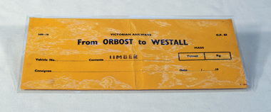
Used at Orbost railway station for the consignment of goods/freight, in this case, timber to Westall. The Bairnsdale-Orbost railway was opened in 1916 to serve the agricultural and timber industry. Because of the decline in traffic and heavy operating costs, the line was finally closed in August, 1987. Orbost Railway Station was opened on Monday 10 April 1916 as the terminus of the Orbost railway line, and closed in 1987. The station was located on the west side of the Snowy River despite the town of Orbost being on the east side of the river, in order to save on the costs of a bridge over the river, which at the time had highly variable levels. This item is associated with the history of the Orbost-Bairnsdale railway line and therefore reflects the role that the rail line played in the social and economic history of Orbost.An unused brown/buff coloured goods/freight consignment envelope used by Victorian Railways, this one for timber from Orbost to Westall. 2498-78 VICTORIAN RAILWAYS From ORBOST to WESTALL Contents TIMBER railway-history orbost-bairnsdale-railway -
 Orbost & District Historical Society
Victorian Railways remarks book, Victorian Railways, c. 1940s
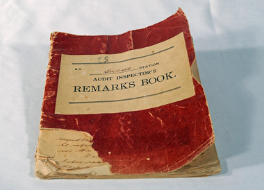
Used at Orbost Railway Station, possibly by the Station Master, between 1944 and 1984. The Bairnsdale-Orbost railway was opened in 1916 to serve the agricultural and timber industry. Because of the decline in traffic and heavy operating costs, the line was finally closed in August, 1987. Orbost Railway Station was opened on Monday 10 April 1916 as the terminus of the Orbost railway line, and closed in 1987. The station was located on the west side of the Snowy River despite the town of Orbost being on the east side of the river, in order to save on the costs of a bridge over the river, which at the time had highly variable levels. This item is associated with the history of the Orbost-Bairnsdale railway line and therefore reflects the role that the rail line played in the social and economic history of Orbost.Book with a red cover. On the front cover VICTORIAN RAILWAYS Audit Inspectors Remarks Book, Orbost. Inside are numbered and lined pages with hand written information dating from 28/3/1944-13/8/1984, dated and signed by various station masters. Cover has a section missing from the bottom left.VICTORIAN RAILWAYS Audit Inspectors Remarks Book, Orbost.railway-history orbost-bairnsdale-railway -
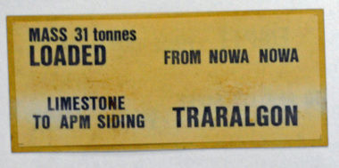 Orbost & District Historical Society
label / sign, 1970's -1980's
This item was used by Victorian Railways in 1980's. It was inserted onto the side of railway freight wagons. The Bairnsdale-Orbost railway was opened in 1916 to serve the agricultural and timber industry. Because of the decline in traffic and heavy operating costs, the line was finally closed in August, 1987. Orbost Railway Station was opened on Monday 10 April 1916 as the terminus of the Orbost railway line, and closed in 1987. The station was located on the west side of the Snowy River despite the town of Orbost being on the east side of the river, in order to save on the costs of a bridge over the river, which at the time had highly variable levels This item is associated with the history of the Orbost-Bairnsdale railway line and therefore reflects the role that the rail line played in the social and economic history of Orbost.A double -sided rectangular shaped label / sign, heavily laminated.Black print on light brown background. On one side : "MASS 31 tonnes LOADED; FROM NOWA NOWA; LIMESTONE TO APM SIDING; TRARALGON". On reverse : "EMPTY FROM TRARALGON; TO APM LIMESTONE SIDING ; NOWA NOWA".freight orbost-bairnsdale-railway