Showing 27535 items
matching yarra-river
-
 Anglesea and District Historical Society
Permit
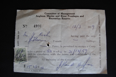
Stamped - initialled receipt being for camping fees for 52 weeks to 31/12/1959. 15 pounds received from Mrs. J. Murch on 12/3/1959.Committee of Management / Anglesea Marine and River Frontages and / Recreation Reserve / No 4990 - 12/3/1959 - Mrs J.Murch. 15 pounds to occupy a camp to 31/12/1959. Signed J. Ken Hughes / Ranger.anglesea marine & river frontages & recreation reserves, j. murch, camping -
 Anglesea and District Historical Society
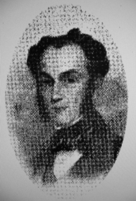
Portrait Photograph, Original photo 1916. Reproduction 2011
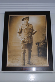
Framed reproduction of sepia photograph of Pte. Alfred John Evans in full WW1 Australian Army uniform printed on canvas - timber frame has gold-toned insert.Metal Plaque attached reads "3139 Pte. Alfred John Evans, 58th Bn. A.I.F / Born, Anglesea River, 20 January 1893 / Died, Ville-sur-Ancre, France, 4 July, 1918".ww1, evans, military -
 Waverley RSL Sub Branch
Plaque H.M.A.S. Derwent
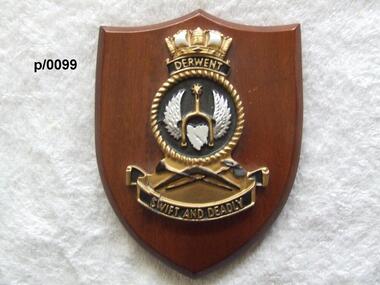
HMAS Derwent (F22/DE 22/DE 49), named for the Derwent River, was a River class destroyer escort of the Royal Australian Navy (RAN). Commissioned in 1964, the ship operated during the Indonesia-Malaysia Confrontation, and was used for filming of the British drama series Warship. The ship was decommissioned in 1994, and was scutted as an artificial reef after use for ship survivability testsInsignia od H.M.A.S. Derwent on wooden shieldH.M.A.S. Derwenth.m.a.s. derwent -
 Greensborough Historical Society
Article, The Separation tree, 2019_
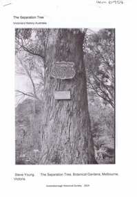
The tree was one of two original red river gums that pre-dated European occupation, and was the site where colonists congregated to celebrate the announcement of Victoria's separation from New South Wales on 15 November 1850. It died as the result of vandalism in 2010 and 2013. Saplings of the original are planted around Melbourne, including along the Plenty River Trail in Greensborough3 p. Wikipedia article; photograph of the tree in the Botanical Gardens, Melbourne (before it was vandalised), and copy of the document of separation of the province of Victoria from the Colony of New South Wales, owned by Colin Boucher..separation tree -
 Greensborough Historical Society
Photograph - Digital image, Portrait of Edward Green, 1850c
Portrait of Edward Green. In the 1840s, Edward B. Green ran the mail service between Melbourne and Sydney and owned a parcel of land on the Plenty River. He engaged a surveyor to draw up plans and lay out a township on the slopes overlooking the river, and to mark out small farm holdings on the flats. This small township named after him is now Greensborough.Digital copy of portrait.edward bernard green, greensborough history -
 Orbost & District Historical Society
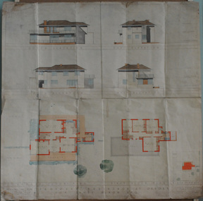
plans, July 1949
These house plans were drawn up for James Nixon. James Nixon was born in Orbost on 15.11.1912. He married Joyce May Thompson on 2.2.1937. He was a well known Orbost identity, serving a record 47 years as a Commissioner on the Snowy River improvement Trust, as well a director of Snowy River Seed and th Bean Board. He died on 21.12.2002.James Nixon, a third generation Nixon, father of Peter Nixon A.O., was an involved and respected Orbost identity. This item is a significant research tool.Architectural plans for a two-storey house with 4 bedrooms to be built on the corner of Gladstone and Tennyson Streets in Orbost. On a white background with coloured drawings ( water colour).nixon-james house-plans architecture -
 Melbourne Tram Museum
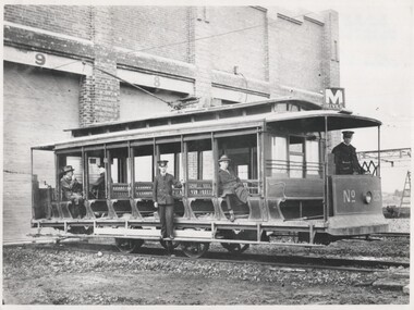
Photograph - Black and White V class 215 at Preston Workshops 1925
Tram originally built for The North Melbourne Electric Tramways and Lighting Co. (NMETL) in 1906 as a straight sill open cross bench tram. Photograph is of the tram body on an un-motored truck or wheel set and has been posed for an official MMTB photograph in 1925, soon after the workshops were completed. It shows the destination of "M River" for Maribyrnong River.Shows the only type of fully open cross bench tram operated by the MMTB. This style was popular as a summer tram in North America. Originally built by Brill (USA) in 1906 and assembled by Duncan and Fraser for the NMETL as Tram No. 14. Taken over by the MMTB in 1922 and given the number 215.Black and White photograph of V class 215 at Preston Workshops 1925.In ink on rear "V class"trams, tramways, v class, preston workshops, tram 215, nmetl, brill, mmtb, uniforms -
 Eltham District Historical Society Inc
Film - Video (VHS), IMP Productions, The Shire of Etham - The Evergreen Shire (Series 69, Item 4), c.1985
Shire of Eltham Archives: Series 69, Item 4 This video was produced for the Shire of Eltham by IMP Productions and provides a description of the shire, 277 square km on a north/northeast axis, some 25 km northeast of the centre of Melbourne with a population of around 40,000. Scenes include Yarra River, rural settings and urban settings, housing estates, Shillinglaw Cottage, Pigeon Bank at Kangaroo Ground, the Eltham Railway Trestle Bridge with reference to the fight by locals in the 1970s to save it from replacement, Montsalvat, mudbrick making and its use as a building material, the use of mudbrick in the Eltham Community Centre blending harmoniously with the environment. Emphasises people living in the area due to the qualities of life provided. Also the Living and Learning Centre, St Andrews Markets and other local markets, the Eltham Leisure Centre, cricket and horse riding at Eltham Lower Park, the Infant Welfare Centre (part of the Eltham War Memorial), how residents are mindful of protecting their historical heritage, the CBA bank and Allwood House at Hurstbridge, Tracey Naughton about the Eltham "As we are" Community Banner project and the “River of Life banner”, the Parks and Gardens office in the former Police Residence building (now the Local History Centre), Alistair Knox Park, road planning and types of roads, tree canopy, Peck's Dam, green carparks, road drainage, Gordon Ford's garden and natural landscapes, and Were Street shops in Montmorency. Planning for shopping facilities and carparks with a population of 40,000 growing to 55,000, Arthur Street Mall and carpark, local village feel in the shopping centre. Councillors and Council staff featured include Mary Grant, Bob Manuell, Rodney Roschellor, John Cohen, Alan Baker. Also scenes of Commercial Place, Diamond Valley Railway, Eltham Galley, Riverclay and canoeing on the Yarra intermingled with images of the shire from the Shire of Eltham Pioneers Photograph collection.VHS Video cassette Converted to MP4 file format 00:11:56; 79MBshire of eltham, video recording, shire of eltham archives, alistair knox park, allwood house, arthur street, arthur street mall, bob manuell, canoeing, carparks, cba bank, commercial place, council staff, councillors, cr. mary grant, cricket, diamond valley railway, eltham community banner project, eltham community centre, eltham galley, eltham leisure centre, eltham living and learning centre, eltham lower park, eltham railway trestle bridge, eltham war memorial, gordon ford garden, horse riding, housing estates, hurstbridge, infant welfare centre, john cohen, kangaroo ground, local history centre, montmorency, montsalvat, mudbrick, parks and gardens, peck's dam, pigeon bank, police residence, river of life banner, riverclay, road drainage, road planning, rodney roschellor, shillinglaw cottage, shire of eltham pioneers photograph collection, st andrews market, tracey naughton, tree canopy, were street, yarra river, alan baker -
 Eltham District Historical Society Inc
Slide, Maroondah Aqueduct, Research, Victoria, 22 Mar. 1981
An inspection tour of the Maroondah Aqueduct was undertaken by the Shire of Eltham Historical Society on Sunday, March 22nd, 1981, commening where the aqueduct crosses Main Rd., Research, just below Eltham College. The Maroondah Aqueduct was part of Melbourne’s water supply system. It carried water over the 66 km from the Maroondah Reservoir on the Watts River at Healesville to the Preston Reservoir. Of this length, 41 km were open channel, 10 km, tunnel through hills and 15 km in 14 inverted siphons across stream valleys. The route of the aqueduct is north of Tarrawarra and Yarra Glen, along the Yarra escarpment south of Christmas Hills and crossing Watsons Creek into the present Shire of Eltham near Henley Rd. The eastern part of the route lies entirely within the former boundaries of the shire. The aqueduct passes south of Kangaroo Ground to Research and crosses the Diamond Creek by siphon at Allendale Rd., Eltham North. It then extends to Reservoir via St. Helena, Greensborough North and Bundoora. Water first flowed through the aqueduct in February 1891 when it was fed by a diversion weir on the Watts River. Records of the building of the aqueduct indicate that it was a significant construction achievement. The present Maroondah Reservoir was completed in 1927 and the aqueduct was enlarged at that time to take increased flows. About 1971 the section of the aqueduct through and north of Research was replaced by a large pipe and that section of the channel is now unused. The channel has remained largely intact (unlike sections at Greensborough and Bundoora where long lengths of the disused aqueduct have been demolished or filled in). The M.M.B.W. relinquished control of the disused aqueduct reserve which is crown land and the Shire of Eltham took control of this section of the reserve as a linear park. The Maroondah Aqueduct is considered to be an important historic structure, not just to the local area but to the metropolitan area generally. It is considered important to preserve substantially intact long lengths of the disused aqueduct, together with its bridges and other associated structures. 35 mm colour positive transparency (1 of 5) Mount - Agfachrome Agfa CS System black 8 dotsactivities, heritage excursion, maroondah aqueduct, research (vic.), shire of eltham historical society -
 Bendigo Military Museum
Letter - LETTER, 1915, Angus MacKAY, C1915
Letter written by Signalman Angus MacKAY 2486 5BTN AIEF at Seymour and addressed to E O'SUllivan ESQ. Delgett Park Street, South Yarra Letter dated 8.7.1915 A single page letter when folded becomes an envelope. Paper is lined and handwritten in black ink. The letter written to his uncle mentions pay and allotment monies.ww1, letter, pay allotments -
 Greensborough Historical Society
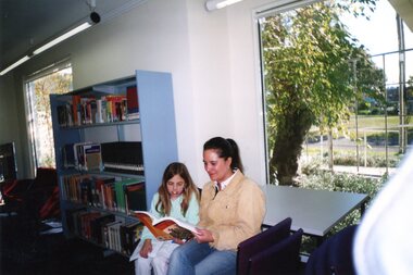
Photograph - Photographs, Rosie Bray, Watsonia Library: Library patrons 2005, 2005
Watsonia Library is a branch of Yarra Plenty Regional Library Service (YPRL). Photographs from the opening of the 2005 refurbishment of the library showing library patrons, parents reading with their childrenColour photographsyarra plenty regional library, yprl, watsonia library -
 National Wool Museum
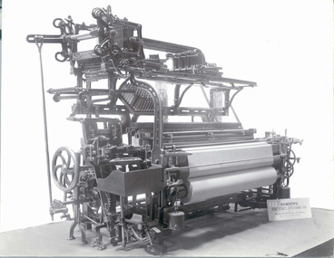
Photograph
Photograph probably for promotional purposes, of a "David Sowden & Sons" loom, No102, "Lasting or Serge de Berrie Loom". Photograph was among items from Yarra Falls Mill.Photograph, sepia, of a "David Sowden & Sons" loom, No102, "Lasting or Serge de Berrie Loom".LASTING OR SERGE DE BERRIE/ LOOM/ DAVID SOWDEN & SONS/SHIPLEYtextile machinery weaving, yarra falls mill david sowden & sons, weaving looms, weaving machinery, textile machinery, weaving -
 National Wool Museum
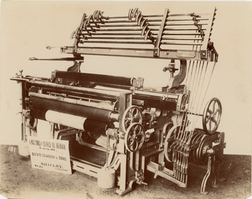
Photograph, Lasting or Serge de Berrie Loom
Photograph probably for promotional purposes, of a "David Sowden & Sons" loom, No101, "Lasting or Serge de Berrie Loom". Photograph was among items from Yarra Falls Mill.Photograph, sepia, of a "David Sowden & Sons" loom, No101, "Lasting or Serge de Berrie Loom".LASTING OR SERGE DE BERRIE/ LOOM/ DAVID SOWDEN & SONS/SHIPLEYtextile machinery weaving, yarra falls mill david sowden & sons, weaving looms, weaving machinery, textile machinery, weaving -
 National Wool Museum
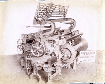
Photograph
Photograph probably for promotional purposes, of a "David Sowden & Sons Patent Automatic Shuttle Changing Loom" No 183. Photograph was with other photographs in an envelope from Yarra Falls Mill.Photograph, black and white, of a "David Sowden & Sons Patent Automatic Shuttle Changing Loom" No 183.183 to firt2 columns/ fig 11/Make 5 3/4 inches widetextile machinery weaving, yarra falls mill david sowden & sons, weaving looms, weaving machinery, textile machinery, weaving -
 Bialik College
Mixed media (Item) - Bialik I.D Style Guide on CD Rom
No date, style guide for Bialik College on CD-rom created by LL Brown Advertising from South Yarra VIC. For use and permissions email the archive at [email protected] college -
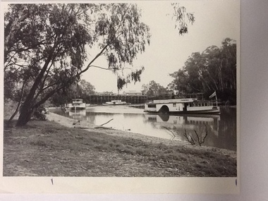 Port of Echuca
Black and white photograph, Approx. 1980
Information of construction of Pride of the Murray. Construction: Composite Tonnage: 71 gross 36 net Dimensions: L 82.4 ft B 15.5 ft D 4.4 Date of Registration: Melbourne 1870 no.88, 918 Built: Echuca, Vic. 1865 Owners: Permewan, Wights & co.This photo has Social and historical significance,depicting some of the boats and the wharf in the 1980's. It gives a very clear visual of the Port of Echuca wharf and the Echuca banks of the Murray with some of the beach visible. Black and white satin photograph of the starboard side of the P. S. Canberra sailing upstream on Murray river between the Port of Echuca wharf and the Echuca bridge. The Pride of the Murray (front on) can be seen further behind , on the left, with the Pevensey, which appears to be moored in front of the wharf in the background. On front of photo paddlesteamers are marked Canberra & Pride of the Murray. On back of the photo is marked in pencil: please return to Mrs H.Coulson, Port of Echuca, Box 35, Echuca.echuca wharf, p.s. canberra -
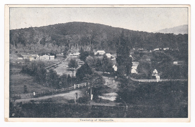 Marysville & District Historical Society
Postcard (item) - Black and white postcard, Nicholas John Caire, Township of Marysville, 1858-1918
One of a series of postcards of photographs taken by socialite photographer Nicholas John Caire. N.J. Caire had a great love for the area and in the late 1800's took many photographs of Marysville and its surrounds.One of a series of postcards of photographs taken by socialite photographer Nicholas John Caire. N.J. Caire had a great love for the area in and surrounding Marysville and in the late 1800's took many photographs of Marysville and its surrounds. N.J. Caire was born in 1837 in Guernsey. He arrived in Adelaide about 1860 along with his parents who encouraged his early interest in photography. He opened a studio in Adelaide in 1867 after traveling extensively throughout the Gippsland taking photographs. After marrying in 1870 he moved to Talbot in Victoria until 1876 when he opened a studio in the Royal Arcade in Melbourne. After 1885 N.J. Caire gave up his city work and made his home in South Yarra and devoted the rest of his life to outdoor photography, specializing in the bush, the gullies and the mountains of south-eastern Victoria. POST CARD The Address to be written on this side This space may be used for Correspondence/ within the Commonwealth at 1d. rate./ Foreign, charged ordinary letter rate. St. Fillans/ Narbethong This is the/ little village we/ visited last week/ E.L. Mrs R.D. Cole/ Mozart Villa/ Bethanga One penny Victorian postage stamp Date Stamp/ Illegible Date Stamp/ JA 16/ 6/ VICTORIA/ Illegiblemarysville, victoria, nicholas john caire, postcard, souvenir -
 Glenelg Shire Council Cultural Collection
Photograph - Photograph - Homestead, Side View, Esther Winifred Hill (Nee Smallpage), 1920
Photographs taken by Esther Winifred Hall (nee Smallpage) - great grand-daughter of Stephen George Henty. Taken in 1934 Centenary Celebrations in Portland.Black and white photograph of house with wide verandah, water tank (on left), behind light-coloured pole and wire fence with metal and wire gate. Donated by Ms. Mary Robinson, acting on behalf of Mrs. W.G. Hutchinson "Tellong", Blackwood River Drive, Balingup, W.A. 6253Front: (no inscriptions) Back: Homestead side view -
Glenelg Shire Council Cultural Collection
Souvenir - Sticker - Glenelg River, n.d
Coloured sticker. Image of Glenelg River at Nelson, oblong, wavy top edge, yellow print along this edge "A Great Place to Relax'; white lettering bottom left hand corner: 'Nelson Victoria'. Sticker attached to white backing, hole in one short end for hanging.souvenir, heywood, nelson, glenelg river -
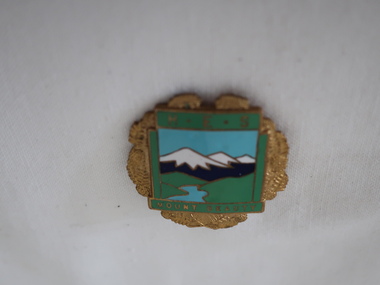 Kiewa Valley Historical Society
Badge Brass - Mt Beauty Higher Elementary School
Schools of this era were very proud of their identity. This was particularly so in country based ones. Schools in isolated or semi-isolated regions provided social cohesion and pride and community involvement that was not so inherent in schools located in larger cities. The exception here being the Greater Public Schools.Mt Beauty formal secondary education commenced in 1950 with the creation of central classes, with an enrolment of 35 pupils at the Mt Beauty Primary School to serve the children of employees on the Kiewa Hydro Electric Scheme and other people of the district. The Mt Beauty HES was proclaimed on 25th May 1958. In 1962 Mt Beauty High School was proclaimed with 213 pupils. ref. Vision & Realisation Pages 1036-1037. This badge was worn by a local girl.Mt Beauty Higher Elementary School badge made from brass. The front is coloured enamel depicting a scene of sky, mountains, grass and river. On the top it has 'H.E.S.' and on the bottom 'Mount Beauty'. The outside edges are decorated with gold colored ferns. See also KVHS 0371mt beauty higher elementary school, school badge, brass badge -
 Federation University Historical Collection
Book - Annual Report 1880, The School of Mines Ballaarat Annual Report, 9 February, 1880, 1880
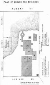
The School of Mines Annual Report, 9 February, 1881, Additional Examination Statute 1880, Balance Sheet, Certificates Granted by Council, Donations and Fees - carriage of, Extracts from Visitors' Book, Fees, Form of Bequest, Honorary Correspondents, Life Governors, Mining and Mineral Contributions Invited - Paper of Particulars, Museum - open to visitors, Office Bearers, Obituary, Report of the Lecturer in Mathematics, Report of the Lecturer in Mining-Land- and Engineering-Surveying, Report of the Lecturer in Mechanical Engineering, Report of the Lecturer in Telegraphy, Report of the Curator of the Museum (with Plans), Report of the Superintendent of Laboratories, Subjects and Lecturers, Subjects and Examiners, Statement of Receipts and Expenditure for the year 1880, Subscriptions and Donations from 1 January to 31 December 1880, The Lal-Lal Iron Ore Deposits - (with Section and Plan)Pale green booklet of 70 pages, Annual Report 1880. Image of Guage Test Tower, Image of The School of Mines, Plan of Ground and Buildings - Albert Street, The School of Mines Ballaarat - The Museum - Plan of Groundfloor, Image of the Lal-Lal Iron Ore Deposits, Moorabool Riverthe school of mines, annual report, additional examination statute 1880, balance sheet, certificates granted by council, donations and fees - carriage of, extracts from visitors' book, fees, form of bequest, honorary correspondents, life governors, mining and mineral contributions invited-paper of particulars, museum open to visitors, office bearers, obituary, report of the lecturer in mathematics, report of the lecturer in mining-land and engineering-surveying, report of the lecturer in mechanical engineering, report of the lecturer in telegraphy, report of the curator of the museum (with plans), report of the superintendent of laboratories, subjects and lecturers, subjects and examiners, statement of receipts and expenditure for the year 1880, subscriptions and donations from 1 january to 31 december 1880, the lal-lal iron ore deposits-(with section and plan), obituary - sir redmond barry - arthur leahy - jacob upfold - john day, mr james oddie, dr. r. f. hudson, john victor, chas. wm. thomas, w. h. shaw, walter d. campbell, ferdinand m. krause, joseph flude, geo. perry, w. hy. barnard, examination statute, his excellency sir wm. f. drummond jervois, charles h. pearson, t. brodribb, professor pepper, james mitchell, robert adam, wm. lant carperter, h. b. de la poer wall, w. h. brokenshire, arthur parker, henry parkinson, c. davies, simon richards, c. v. gorton, c. r. blackett, david jones, wilberforce dyke, ferdinand krause, ballarat school of mines museum, ballarat school of mines museum plan, lal lal ore deposits, moorabool river, william land carpenter, william jervois, william henry tbarnard -
Bendigo Historical Society Inc.
Map - NOLAN : COUNTY OF BENDIGO, 22-7-13
Map. Nolan, County of Bendigo, Egerton, Elmore, Goornong, Northern Railway, Campaspe River. By authority A.J.Mullett, Government Printer, Melbourne. Photo-Lithographed at the Deptartment of Lands and Survey, Melbourne by W.J. Butson 22-7-13. Price 1/-. (number 79 in map cupboard 1)A.J. Mullett, Government Printer, Melbourne.map, bendigo, nolan -
Bendigo Historical Society Inc.
Map - NOLAN : COUNTY OF BENDIGO, 7-5-30
Map. Nolan, County of Bendigo, Egerton, Elmore, Goornong, Campaspe River, Northern Railway. By Authority H.J. Green, Government Printer, Melbourne. Drawn and reproduced at the Department of Lands and Survey, Melbourne, Victoria.7-5-30. Price 2/-. (number 78 in map cupboard 1)H.J. Green, Government Printer, Melbourne.map, bendigo, nolan -
Bendigo Historical Society Inc.
Map - JANIEMBER WEST : COUNTY OF BENDIGO, September 1955
Map. Janiember West, County of Bendigo, Powlett, Janiember East, Jarklan, Kinypanial, River Loddon, Kelsh's Lagoon. By authority W.M. Houston, Government Printer. Drawn and reproduced at the Department of Lands and Survey, Melbourne. Price 2/-.September 1955. (number 64 in map cupboard 1)W.M. Houston, Government Printermap, bendigo, janiember west -
 Bendigo Historical Society Inc.
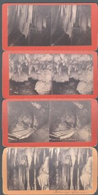
Photograph - WES HARRY COLLECTION: 4 STEROEGRAPHIC CARDS, ?
Four Stereographic cards, all showing views inside of the Jenolan Caves. On the reverse is stamped ' Picturesque Stereoscopic Views of Jenolan Caves and Blue Mountains, Photographed and Published by J. Rowe, Jenolan Caves., (a) Queens Diamonds , (b) Decent to River , (c) Shawls , (d) Jersey Castle ?J. Roweplace, jenolan caves, j. rowe, jenolan caves, blue mountains, stereoscopic views, queens diamonds, decent to river , shawls -
Bendigo Historical Society Inc.
Map - HAWKESTONE : COUNTY OF BENDIGO, December 1953
Map. Hawkestone, County of Bendigo, County of Talbot, Sutton Grange, Redesdale, Faraday, Elphinstone, Metcalfe, Coliban River. By authority W.M. Houston, Government Printer. Drawn and reproduced at the Department of Lands and Survey, Melbourne. December 1953. Price 5/-. (number 97 in map cupboard 1)W.M. Houston, Government Printer.map, bendigo, hawkestone. -
Tatura Irrigation & Wartime Camps Museum
Memorabilia - Photograph
Used in September November 1991 Duplicate photos. Grey with 13 white stripes horizontal. Attractive picture of snow clad mountains - fir trees reflected on the river. Tatura & District Historical Society Museum album. superimposed on the scene. Photographs of exhibits on display. Wartime camps room 1243 top right corner.photographs