Showing 8867 items matching " construction"
-
 Bendigo Historical Society Inc.
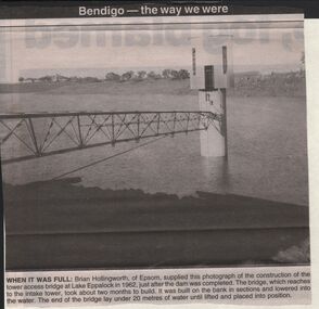
Newspaper - JENNY FOLEY COLLECTION: WHEN IT WAS FULL
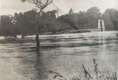
BHS CollectionBendigo advertiser ''The way we were'' from 2003. When it was full: Brian Hollingworth of Epsom, supplied this photograph of the construction of the tower access bridge at lake Eppalock in 1962, just after the dam was completed. The bridge, which reaches to the intake tower, took about two months to build. It was built on the bank in sections and lowered into the water. The end of the bridge lay under 20 metres of water until lifted and placed into position. The clip is in a folder.newspaper, bendigo advertiser, the way we were -
 Melbourne Tram Museum
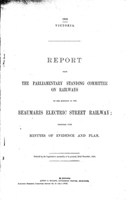
Document - Report, Victorian Parliament, "Report - The Parliamentary Standing Committee re the Beaumaris Electric Street Railway.", Dec. 1916
Printed - 6 page foolscap, stapled on left hand side, 2 sections, Victorian State Parliamentary Report titled "Report - The Parliamentary Standing Committee on Railways on the question of the Beaumaris Electric Street Railway." - dated 22 December 1916. References previous reports, Black Rock, Beaumaris, residential development, routes and costs of the proposed tramway, costs provided by the Chief Engineer for Railway Construction, E. Kernot, and Committee recommendations - tempered by the War.trams, tramways, sandringham, black rock, beaumaris, railways, tramways, proposals -
 Orbost & District Historical Society
album, Orbost Visitor Information Centre, 1997
The original slab hut was built in 1872 as a family dwelling on a site about 3 km upstream from the junction of the Buchan and Snowy Rivers about 40 kms from Orbost on the Yalmy Rd. No nails were used in the construction; it was all wired together. After a period in storage the Slab Ht was opened in its present location in Orbost as the Information Centre in 1987. This album documents an important event in Orbost.A photo album with a navy blue cardboard cover with gold embossing on the front and spine. It contains 32 photos of the 1997 10 year anniversary celebration of the establishment of the Slab Hut - the Orbost Visitor Information Centre. It also contains 3 postcards and 2 fridge magnets.slab-hut album orbost -
 Kiewa Valley Historical Society
Folder - Retail Development of Mt Beauty
The papers have been collected in correspondence since 1947 and cover many of the retail shops in Mt Beauty. The sale of the shops by the State Electricity Commission during the 1960's when the construction of the Kiewa Hydro Electric Scheme was completed. Owners of the Mt Beauty Supermart and Newsagency and Falls Creek Mini-Mart, Samuel Keith Pearce and Gordon Cathew Pearce's documents are included. The papers record a period when the SECV sold the retail shops in Mt Beauty after the completion of the Kiewa Hydro Electric Scheme. This enables researchers to gauge the value of the properties at the time and the changes in retail shops from that time.A black plastic folder containing a collection of correspondence pertaining to the retail development of Mt Beauty from the 1940's through to the 1960's and 1970's. pearce bros. mt beauty. falls creek. mt beauty retail. state electricity commission of victoria. -
 Warrnambool and District Historical Society Inc.
Plumb bob, Early 20th century
A plumb bob or plummet is a weight suspended from a string or rod and used as a vertical reference line or plumb line. It is the vertical equivalent of the water level. It is used to ensure constructions are plumb or level. It has been in use since Egyptian times and is also used in surveying. It is still in use today. This plumb bob weighs 910 grams and was probably used in the building trade. This item is retained as an interesting example of a trade tool from the past.This is a brass weight with a bulbous-shaped body rounded on the bottom, a slender neck and an enclosed top. The top has a metal ring to which is attached a metal rod with a ring at the end. The item is a little stained.building accessories, history of warrnambool -
 Eltham District Historical Society Inc
Slide, Quinn Estate, Sackville Street, Montmorency, 15 Sep. 1982
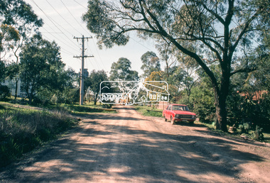
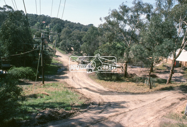
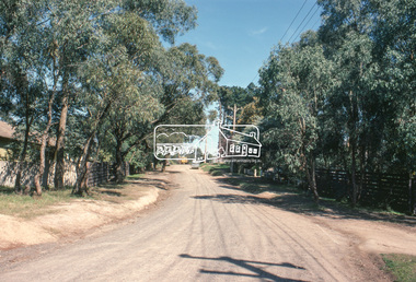
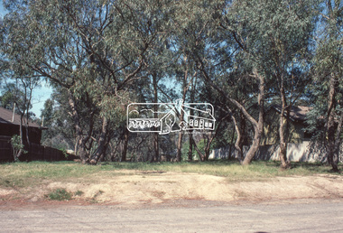
One of a series of images of roads and infrastructure taken by Eltham Shire Council Planning and Engineering officers of the Quinn Estate in Montmorency, Stage 1, Private Street Scheme during construction, September 1982. They provide perspective of the changes in housing styles and road development that began sweeping in from the mid 1970s with increasing urbanisation of what was once more outlying suburbs and regions.35 mm colour positive transparency (1 of15) Mount - Kodak Kodachrome CardProcessed 15 Sep1980housing estate, infrastructure, montmorency, quinn estate, roads, sackville street, private street scheme -
 Eltham District Historical Society Inc
Slide, Quinn Estate, Quinn Way, Montmorency, 15 Sep. 1982
One of a series of images of roads and infrastructure taken by Eltham Shire Council Planning and Engineering officers of the Quinn Estate in Montmorency, Stage 1, Private Street Scheme during construction, September 1982. They provide perspective of the changes in housing styles and road development that began sweeping in from the mid 1970s with increasing urbanisation of what was once more outlying suburbs and regions.35 mm colour positive transparency (1 of15) Mount - Kodak Kodachrome CardProcessed 15 Sep1980housing estate, infrastructure, montmorency, quinn estate, roads, sackville street, private street scheme, quinn way -
 Eltham District Historical Society Inc
Slide, Quinn Estate, Cressy Street, Montmorency, 15 Sep. 1982
One of a series of images of roads and infrastructure taken by Eltham Shire Council Planning and Engineering officers of the Quinn Estate in Montmorency, Stage 1, Private Street Scheme during construction, September 1982. They provide perspective of the changes in housing styles and road development that began sweeping in from the mid 1970s with increasing urbanisation of what was once more outlying suburbs and regions.35 mm colour positive transparency (1 of15) Mount - Kodak Kodachrome CardProcessed 15 Sep1980housing estate, infrastructure, montmorency, quinn estate, roads, private street scheme, cressy street, nicholas lauder real estate -
 Eltham District Historical Society Inc
Slide, Quinn Estate, Reichelt Avenue, Montmorency, 15 Sep. 1982
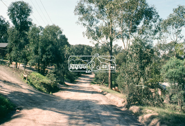
One of a series of images of roads and infrastructure taken by Eltham Shire Council Planning and Engineering officers of the Quinn Estate in Montmorency, Stage 1, Private Street Scheme during construction, September 1982. They provide perspective of the changes in housing styles and road development that began sweeping in from the mid 1970s with increasing urbanisation of what was once more outlying suburbs and regions.35 mm colour positive transparency (1 of15) Mount - Kodak Kodachrome CardProcessed 15 Sep1980housing estate, infrastructure, montmorency, quinn estate, roads, private street scheme, mccarthy grove, reichelt avenue -
 Eltham District Historical Society Inc
Slide, Quinn Estate, Reichelt Avenue, Montmorency, 15 Sep. 1982
One of a series of images of roads and infrastructure taken by Eltham Shire Council Planning and Engineering officers of the Quinn Estate in Montmorency, Stage 1, Private Street Scheme during construction, September 1982. They provide perspective of the changes in housing styles and road development that began sweeping in from the mid 1970s with increasing urbanisation of what was once more outlying suburbs and regions.35 mm colour positive transparency (1 of15) Mount - Kodak Kodachrome CardProcessed 15 Sep1980housing estate, infrastructure, montmorency, quinn estate, roads, private street scheme, reichelt avenue -
 Eltham District Historical Society Inc
Slide, Quinn Estate, Buena Vista Drive, Montmorency, 15 Sep. 1982
One of a series of images of roads and infrastructure taken by Eltham Shire Council Planning and Engineering officers of the Quinn Estate in Montmorency, Stage 1, Private Street Scheme during construction, September 1982. They provide perspective of the changes in housing styles and road development that began sweeping in from the mid 1970s with increasing urbanisation of what was once more outlying suburbs and regions.35 mm colour positive transparency (1 of15) Mount - Kodak Kodachrome CardProcessed 15 Sep1980housing estate, infrastructure, montmorency, quinn estate, roads, private street scheme, buena vista drive -
 Eltham District Historical Society Inc
Slide, Quinn Estate, Reichelt Avenue, Montmorency, 15 Sep. 1982
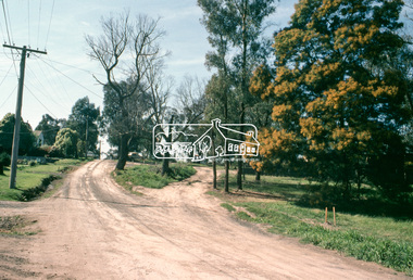
One of a series of images of roads and infrastructure taken by Eltham Shire Council Planning and Engineering officers of the Quinn Estate in Montmorency, Stage 1, Private Street Scheme during construction, September 1982. They provide perspective of the changes in housing styles and road development that began sweeping in from the mid 1970s with increasing urbanisation of what was once more outlying suburbs and regions.35 mm colour positive transparency (1 of15) Mount - Kodak Kodachrome CardProcessed 15 Sep1980housing estate, infrastructure, montmorency, quinn estate, roads, private street scheme, footpaths and gutters, reichelt avenue -
 Eltham District Historical Society Inc
Slide, Quinn Estate, Reichelt Avenue, Montmorency, 15 Sep. 1982
One of a series of images of roads and infrastructure taken by Eltham Shire Council Planning and Engineering officers of the Quinn Estate in Montmorency, Stage 1, Private Street Scheme during construction, September 1982. They provide perspective of the changes in housing styles and road development that began sweeping in from the mid 1970s with increasing urbanisation of what was once more outlying suburbs and regions.35 mm colour positive transparency (1 of15) Mount - Kodak Kodachrome CardProcessed 15 Sep1980housing estate, infrastructure, montmorency, quinn estate, roads, private street scheme, reichelt avenue -
 Eltham District Historical Society Inc
Slide, Quinn Estate, McCarthy Grove, Montmorency, 15 Sep. 1982
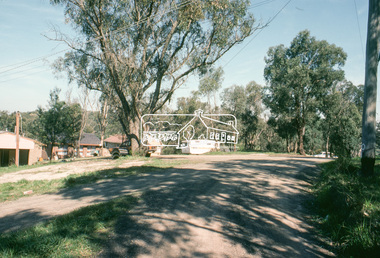
One of a series of images of roads and infrastructure taken by Eltham Shire Council Planning and Engineering officers of the Quinn Estate in Montmorency, Stage 1, Private Street Scheme during construction, September 1982. They provide perspective of the changes in housing styles and road development that began sweeping in from the mid 1970s with increasing urbanisation of what was once more outlying suburbs and regions.35 mm colour positive transparency (1 of15) Mount - Kodak Kodachrome CardProcessed 15 Sep1980housing estate, infrastructure, montmorency, quinn estate, roads, private street scheme, mccarthy grove -
 Eltham District Historical Society Inc
Slide, Quinn Estate, McCarthy Grove, Montmorency, 15 Sep. 1982
One of a series of images of roads and infrastructure taken by Eltham Shire Council Planning and Engineering officers of the Quinn Estate in Montmorency, Stage 1, Private Street Scheme during construction, September 1982. They provide perspective of the changes in housing styles and road development that began sweeping in from the mid 1970s with increasing urbanisation of what was once more outlying suburbs and regions.35 mm colour positive transparency (1 of15) Mount - Kodak Kodachrome CardProcessed 15 Sep1980housing estate, infrastructure, montmorency, quinn estate, roads, private street scheme, mccarthy grove -
 Eltham District Historical Society Inc
Slide, Quinn Estate, Sackville Street, Montmorency, 15 Sep. 1982
One of a series of images of roads and infrastructure taken by Eltham Shire Council Planning and Engineering officers of the Quinn Estate in Montmorency, Stage 1, Private Street Scheme during construction, September 1982. They provide perspective of the changes in housing styles and road development that began sweeping in from the mid 1970s with increasing urbanisation of what was once more outlying suburbs and regions.35 mm colour positive transparency (1 of15) Mount - Kodak Kodachrome CardProcessed 15 Sep1980housing estate, infrastructure, montmorency, quinn estate, roads, private street scheme, sackville street, t-bowl -
 Eltham District Historical Society Inc
Slide, Quinn Estate, Reichelt Avenue, Montmorency, 15 Sep. 1982
One of a series of images of roads and infrastructure taken by Eltham Shire Council Planning and Engineering officers of the Quinn Estate in Montmorency, Stage 1, Private Street Scheme during construction, September 1982. They provide perspective of the changes in housing styles and road development that began sweeping in from the mid 1970s with increasing urbanisation of what was once more outlying suburbs and regions.35 mm colour positive transparency (1 of15) Mount - Kodak Kodachrome CardProcessed 15 Sep1980housing estate, infrastructure, montmorency, quinn estate, roads, private street scheme, reichelt avenue -
 Eltham District Historical Society Inc
Slide, Quinn Estate, Reichelt Avenue, Montmorency, 15 Sep. 1982
One of a series of images of roads and infrastructure taken by Eltham Shire Council Planning and Engineering officers of the Quinn Estate in Montmorency, Stage 1, Private Street Scheme during construction, September 1982. They provide perspective of the changes in housing styles and road development that began sweeping in from the mid 1970s with increasing urbanisation of what was once more outlying suburbs and regions.35 mm colour positive transparency (1 of15) Mount - Kodak Kodachrome CardProcessed 15 Sep1980housing estate, infrastructure, montmorency, quinn estate, roads, private street scheme, reichelt avenue -
 Mission to Seafarers Victoria
Postcard - Postcard, Sepia, Valentines Real Photo Series, The Missions to Seamen Institute, Melbourne Victoria, c. 1922
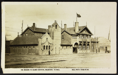
This postcard depicts the urban setting of the Mission to Seafarers a few years after its construction. (the Dome, the last part erected, was opened on 21 October 1921). It demonstrates a lack of urban surrounds or buildings as well as a paved road and a horse-drawn wagon. The figure in the photo is also a record of the dress style of the era. The lady is most likely a member of the Ladies' Harbour Lights Guild.This postcard demonstrates that the building was deemed important enough to be photographed for a postcard. It is a record of what the Mission to Seafarers looked like two years after its construction, and its urban surrounding.Sepia postcard of the Mission to Seafarers building complex and surrounding streets. The postcard depicts a wagon and a woman walking by the complex wearing a black dress and coat and black hat and holding an umbrella. Front: THE MISSIONS TO SEAMEN INSTITUTE, MELBOURNE VICTORIA REAL PHOTO SERIES.M.1696 Reverse: PUBLISHED BY THE VALENTINE & SONS PUBLISHING CO.LTD / MELBOURNE SYDNEY & BRISBANE. Contains logo of VALENTINES REAL PHOTO SERIES POSTCARD. Stamp logo lists: BRANCHES / SYDNEY / LONDON / DUNDEE / DUBLIN / CAPETOWN / MONTREAL / TORONTO Handwritten in blue: 1919mission to seafarers, melbourne, mission to seamen, seamen's mission, norla dome, flag, flying angel, lady, horse cart, umbrella, flinders street extension, ships, australian wharf, valentine's postcards, real photo series postcards, st peter chapel, lhlg, architecture, walter richmond butler -
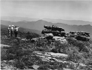 Halls Gap & Grampians Historical Society
Photograph - B/W, C 1960s
A track to the top of Mt William existed many years before, an all weather road was constructed in the early 1960s Not only did engineers and construction workers enjoy some spectacular scenery during "smokos" but so have thousands of tourists Some even experiencing the freezing gale force winds which greeting Major Thomas Mitchell and his party in July 1836sPhoto shows 3 men looking over to Wonderland Range from Mt William. Two men are wearing hard hats The third man a felt hat - he is pointing to a point in the distanceWMT (Wimmera Mail Times}access routes, walking track, roads, mount william -
 Kiewa Valley Historical Society
A) Document - The Field Welding of No. 1 Pipeline - Kiewa. B) Book - SECV, Kiewa Hydro Electric Works, Foreman's Guide, A) by J. M. Scott, Welding Inspector B) by State Electricity Commission of Victoria
No. 1 Pipeline heads down the mountain from McKay Power Station (the Kiewa Hydro Electric Scheme) and can be seen from the Falls Creek Rd.. The pipeline is 1635m long. It was built on the mountain rather than as a tunnel inside the mountain - "It was argued that a pressure pipeline on the surface, while not actually cheaper than the tunnel could possibly save one year in construction time.'The document is a report on the welding involved on the No. 1 pipeline. J. M. Scott was the welding inspector for the SECV on the Kiewa Hydro Electric Scheme. The book is produced by the SECV and is the 'Foremen's Guide' and includes rules and regulations across all areas.A) 10 pages of a 'field record' all pages typed on one side. Stapled on top left corner B) Small, fat book c190 pages plus appendix. Thick and 'tattered looking'. Bound by flexible 'cloth?'(linen?) and fastened with 2 rusty fasteners.B) Cover - F/M J. Scott and red SEC stamp. Inside cover: "checked ... 22-8-55" and "checked 18-11-55"j.m. scott welding inspector, no 1 pipeline mckay power station, kiewa hydro electric scheme -
 Eltham District Historical Society Inc
Negative - Photograph, George W. Bell, Re-erection of Shillinglaw Cottage, c.1966
View looking up from near the Eltham Railway Trestle Bridge over what was to become the Eltham Common at Shillinglaw Cottage in its new location prior to restoration. The former Gahan house, seen in the background was demolished in 1968 when the Main Road was duplicated in this section. The Eltham Common was taken over with the construction of the new Eltham Library which opened in 1994.Shillinglaw Cottage is itself historically, aesthetically and socially significant to the Shire of Nillumbik and is registered on the Victorian Heritage Database. This photo forms part of a collection of photographs gathered by the Shire of Eltham for their centenary project book, "Pioneers and Painters: 100 years of the Shire of Eltham" by Alan Marshall (1971). The collection of over 500 images is held in partnership between Eltham District Historical Society and Yarra Plenty Regional Library (Eltham Library) and is now formally known as 'The Shire of Eltham Pioneers Photograph Collection.' It is significant in being the first community sourced collection representing the places and people of the Shire's first one hundred years.Digital image 4 x 5 inch B&W Negsepp, shire of eltham pioneers photograph collection, eltham, shillinglaw cottage, eltham shire office, gahan house, derril, gahan, george w. bell collection, houses, main road -
 Kew Historical Society Inc
Photograph - Kew Junction, Herald & Weekly Times, 1962
This is an aerial oblique image looking north. It shows Kew Junction before construction of VicRoads (Country Roads Board), Murphy's (Leo's) supermarket, and office towers. It also shows a building on the land now known as the Raoul Wallenberg Reserve, the Kew Municipal Offices in Walpole Street, and St Paul's School for the Blind in Fernhurst Grove, and Kew Bowling Club in Wellington Street.An aerial photograph of Kew Junction, showing the intersection of High Street South, Studley Park Road, Princess Street, High Street and Denmark Street. A number of buildings, now demolished can be identified in the photo, including Jellis’ Bakeries on the corner of Princess Street and Studley Park Road." Annotation on reverse: "Kew Historical Society from Mr L. H. Chinner".kew junction, aerial photograph (kew), oblique aerial, st paul's school for the blind, kew municipal offices, high street kew, studley park road, kew war memorial, kew post office, kew police station, kew court house, high street south, kew, wellington street kew, denmark street kew -
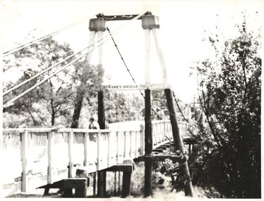 Kew Historical Society Inc
Photograph - Photograph (copy), Kanes Bridge, Studley Park, 195-1955
In 1928 a footbridge was erected to link Kew with the public golf course across the Yarra. The total cost of construction came to 250 pounds and the bridge became known as Kane's Bridge. During the 1934 floods the bridge was washed downstream, and was subsequently rebuilt. The present form of the bridge resembles the earlier bridge which crossed from the Yarra Bend Asylum to Kew, further upstream. (VHD)This work forms part of the collection assembled by the historian Dorothy Rogers, that was donated to the Kew Historical Society by her son John Rogers in 2015. The manuscripts, photographs, maps, and documents were sourced by her from both family and local collections or produced as references for her print publications. Many were directly used by Rogers in writing ‘Lovely Old Homes of Kew’ (1961) and 'A History of Kew' (1973), or the numerous articles on local history that she produced for suburban newspapers. Most of the photographs in the collection include detailed annotations in her hand. The Rogers Collection provides a comprehensive insight into the working habits of a historian in the 1960s and 1970s. Together it forms the largest privately-donated collection within the archives of the Kew Historical Society.A photographic copy of an older photograph of Kanes Bridge."Kanes Bridge"kanes bridge, yarra river, bridges - kew (vic.) -
 Kew Historical Society Inc
Photograph - Kane's Bridge on the Yarra River, December 1934
In 1928 a footbridge was erected to link Kew with the public golf course across the Yarra. The total cost of construction came to 250 pounds and the bridge became known as Kane's Bridge. During the 1934 floods the bridge was washed downstream, and was subsequently rebuilt. The present form of the bridge resembles the earlier bridge which crossed from the Yarra Bend Asylum to Kew, further upstream. (VHD)Original, black and white positive of Kane's Bridge in December 1934, when the 'great flood' of the Yarra caused the bridge's destruction. Inscribed verso: "Kane's Bridge Yarra in flood Dec 1934"river yarra, yarra -- kew (vic.), kanes bridge, 1934 floods -
 Kew Historical Society Inc
Photograph - Kane's Bridge destroyed by the 1934 Flood, 1934
In 1928 a footbridge was erected to link Kew with the public golf course across the Yarra. The total cost of construction came to 250 pounds and the bridge became known as Kane's Bridge. During the 1934 floods the bridge was washed downstream, and was subsequently rebuilt. The present form of the bridge resembles the earlier bridge which crossed from the Yarra Bend Asylum to Kew, further upstream. (VHD)Black and white positive print (identical to 2021.70 but with a different annotation) showing the destruction of Kane's Bridge in the floods of 1934. The Kodak paper would indicate a 1950s reprinting.Annotation verso: "Kane's Bridge in 1934 flood / Dec. 1934.kane's bridge, river yarra, yarra valley, 1934 floods -
 Brighton Historical Society
Dress, Evening dress, 1963
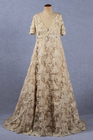
This gown was the winning entry in the Mannequins and Models Guild's Gown of the Year competition, held at the Chevron Hilton Hotel, Melbourne in November 1963 in aid of the Torch Bearers for Legacy. Designed by Lorna White for Hartnell of Melbourne and modelled by Marien Brindley, the dress’s construction is reputed to have consumed 300 hours, with the finished dress weighing 6 kilograms and costing around 3000 pounds. Evening gown made of cream ribbon lace and a rich latte-colured satin; applied beading. Cut with a high waist, short sleeves and deep V at centre back. Boned interior bodice. Centre back zip and train. gown of the year, hartnell of melbourne, lace, beading, ralph samuel, lorna white, marien brindley -
 University of Melbourne, Burnley Campus Archives
Photograph - Black and white print, Principal's Residence, 1913
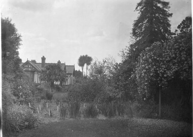
Note from T.H. Kneen 13 February 1991, "Right hand tall tree is Californian Redwood. Over Pergola-Banksia Rose." On 19 November 1991, "Weatherboard construction of right rear of residence was modified/replaced to provide a bedroom for Mr. McLennan's family - he had 6 daughters. That room was later converted to a bathroom with three large storage cupboards." 2 copies black and white photograph. B91.17 and B91.18. View of various trees, shrubs and flowers. House on rise. On reverse "1913."trees, shrubs, flowers, californian redwood, mr. mclennan, principal's residence, principal's house, cordyline