Showing 19907 items
matching orbost-show
-
 Orbost & District Historical Society
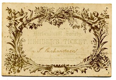
membership ticket, September 1 1874
The Richardson family was one of the very early settler families to establish themselves in the Orbost district. Samuel Richardson was a sawmiller and farmer in Orbost. He built The Curlip, a wooden paddle-steamer of 9 tons gross and dimensions of 43 feet long, 10 feet wide and a depth of 3 feet, on the slipway at their Tabarra sawmill in 1890. The Ballarat Horticultural Society was established in 1859 by a group of thirteen men with the aim of establishing an association for all lovers of horticulture. There were many such societies throughout the colonies making a contribution to their communities. In May 1852 Richard Wicking and his younger brother Frederick followed their father’s footsteps, leaving England to pursue a new life in the distant colony of Port Phillip. Sailing on the maiden voyage of the 'Roxburgh Castle' a new purpose built ship for the long voyages from London to Australia. Arriving on August 28th 1852, having paid their own fares they were "Unassisted Passengers". The brothers spent two years in Melbourne. He spent some tome in Ballarat and became a prominent community member involved in many areas.The Richardson family was one of the very early settler families to establish themselves in the Orbost district. Samuel Richardson was builder of the Paddle Steamer Curlip. This is a useful research tool. An ornately designed card with an oval frame of flowers and cherubs. It is a Ballarat Agricultural Society membership ticket made out to Mr S. Richardson (hand written) and endorsed by R. Wicking , the secretary.on back - hand-written - "J E Richardson"ballarat-horticultural-society richardson-samuel -
 Greensborough Historical Society
Slide - Photograph, John Ramsdale, Rattray Road erosion: Slide 2, 1990s
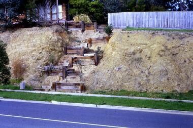
Photograph shows a retaining wall leading up an embankment to a fence line. This shows erosion on Rattray Road Montmorency.Part of the John Ramsdale collection of slides and audio visual material.Colour photograph scanned from slide.erosion, rattray road montmorency -
 Greensborough Historical Society
Photograph - Digital image, Panorama Overlooking Greensborough, 1925c
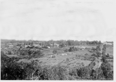
Photograph shows the view overlooking the Greensborough township in the first half of the 20th Century. It shows the rural nature of the area.Digital copy of black and white photograph.greensborough -
 Greensborough Historical Society
Newspaper clipping, Valley Art, 2000_06
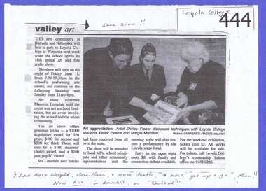
Article discusses the Loyola College Art Show and the photograph shows two Loyola students with artist Shirley Fraser. Shirley Fraser was involved in many community activities. She was a member of the pioneering Black family of Bundoora and Watsonia and a member of GHS. Photocopy of newspaper article. Text and photograph. Written in pen by Shirley Fraser: “June 2000” and “I had more weight, more hair, more teeth, and more “get up and go” then!! Now all is downhill or “shifted”!!” loyola college, loyola art show, shirley fraser, shirley black, xavier pearce, margie morrison, artists -
 Bendigo Military Museum
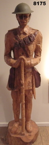
Sculpture - WOODEN STATUE, Unknown
There is a story to this carving, its history and making, this is being put together. The item is on display in the front lounge entrance to the Bendigo District RSL Havilah Road.Hand carved statue brown colours representing an Australian soldier with a rifle in the “Rest on your Arms” position. The carving shows one bandolier, side pack and bayonet, the helmet is a real steel one with chin strap.brsl, smirsl, bdrslinc, statue -
 Bendigo Military Museum
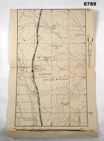
Map - MAP, RAVENSWOOD, VIC TRAINING AREA, Aust Army
Items in the collection re Lt Col J. Swatton, refer Cat No 6719.2P for his service details.This is an enlarged version of a contour map. It is undated. On centre left is Ravenswood Train station. The Calder Highway is shown, from the bottom of the map to halfway up left side. Top right side shows "Spring Hill".Each grid square is 1000 x 1000 yards. Top right corner grid is 230,000 E, 450,000 Nth. Magnetic variation when this map was made is 6.55' grid to magnetic Nth. printed onto the map, with an "X" are 'Starting Point', "Debussing Point", and "Assembly Point" . Handwritten in red pencil at top LHS are the letters "C.O".passchendaele barracks trust, map, j.w. swatton -
 Bendigo Military Museum
Photograph - PHOTOGRAPH, FRAMED WW1, Wayne Eels, C.2008/2009
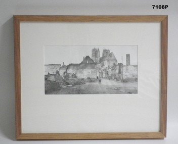
The Grinton Collection. The village of Corbie on the Somme River showing war damage, the streets have been cleared. Refer Cat No. 1280 for Jack Grintons service details. Photograph framed. Photograph - black and white photograph on paper, depicting a village scene of buildings. A number of buildings show some war damage, Frame - timber, light varnish finish, Perspex front, cardboard backing."Group 2: Burden of War", "A. Corbie",framed accessories, camera on the somme, ww1, 38th bn, grinton, villages -
 Bendigo Military Museum
Photograph - PHOTOGRAPH, FRAMED WW1, Wayne Eels, C.2008/2009
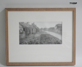
The Grinton Collection. The village of “Bray” on the Somme showing some war damage. Refer Cat no. 1280 for Jack Grintons service details Photograph framed. Photograph - black and white photograph on paper, depicting a village scene with a road and buildings. A number of buildings show war damage, Frame - timber, light varnish finish, Perspex front, cardboard backing."Group 2: Buden of War". "B. Bray".framed accessories, camera on the somme, '38th bn, grinton, villages, ww1 -
 Warrnambool and District Historical Society Inc.
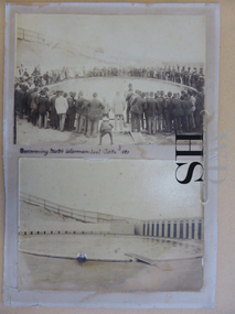
Photographs, Hot Seawater Baths Warrnambool, Circa 1890
The sea water baths were built in 1876 on the line of the railway track and were moved to the Gilles Street site with the advent of the railway. Salt water was drawn from the sea by a windmill and later by steam pump. The main pool was 100 feet by 50 feet. The present site of Heritage Works, the offices of the Warrnambool & District Society Inc. and Warrnambool Family History Group, is on the area of the Town of Warrnambool's Swimming Baths of 1890s. The Warrnambool seabaths have social and historical significance to the local area.Two sepia photographs depicting the baths. The top photo shows people in the pool with a large number of mainly men around the edge of the pool. The bottom photo depicts an empty pool. Mounted on dark cream card. Text between photos states, “ Swimming match Warrnambool Baths 1890.sea water baths warrnambool, sea water baths warrnambool photos, warrnambool history -
 Marysville & District Historical Society
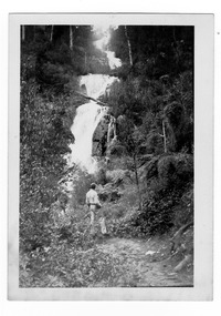
Photograph (item) - Black and white photograph, 1947
A black and white photograph of Steavenson Falls in Marysville in Victoria.A black and white photograph of Steavenson Falls in Marysville in Victoria. The Steavenson Falls is named after the Victorian Assistant Commissioner of Roads & Bridges, John Steavenson who arrived in Victoria in the early 1860's.Stevens Falls. Marysvi/ -lle. Oct.47. 39stevens falls, steavenson falls, marysville, victoria, waterfalls, photograph, john steavenson -
 Bendigo Military Museum
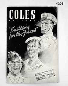
Booklet - BOOKLET, WW2, Johnson, Fear and Kingham PTY LTD, Coles Present "Knitting for the Forces", Post 1939
The booklet was published for “Coles Stores” Australia wide.The front cover shows in B & W drawings of the 3 Forces, inside is 15 pages in black print on white paper of instructions for knitting garments deemed most suitable for the Armed Forces as per the front cover.On the back of page 15 is a 7 inch ruler marking for measurement.coles, knitting -
 Federation University Historical Collection
Photograph, Dr Ron Wild, 27/10/1994
Ballarat School of Mines Director, Dr Ron Wild (right) shows Tertiary Educaton Arts and Gamining Minister Haddon Storey plans for the 76 millions dollar development. Barry Traynor MP at extreme left. ballarat school of mines, ron wild, barry traynor, haddon storey -
 Bendigo Military Museum
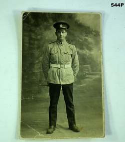
Photograph - PHOTOGRAPH B & W, Possibly pre WW1
B/W photograph, in the style of a post card. Shows a standing soldier wearing a peaked cap. Has crowns on his badges. Charles Eric Phillips = White Hills Bendigo. Prints of postcard by Kodak Australia.Rear is marked 'Eric in uniform age 18 years'. photography-photographs, uniforms -
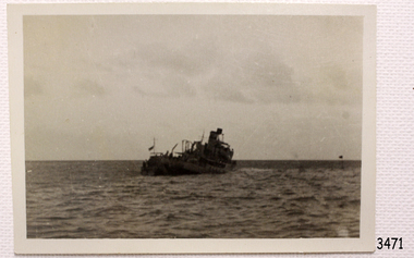 Flagstaff Hill Maritime Museum and Village
Photograph - Shipwreck rescue, Royal Australian Navy (RAN), HMAS Warrnambool J202, 13-09-1947
This photograph was taken at the scene of the wreck of the HMAS Warrnambool J202 on September 13th 1947. The photographer has captured the ship as it sinks at sea. The HMAS Warrnambool J202 was commissioned by the Royal Australian Navy for use as a minesweeper during World War II. The Bathurst Class Corvette, fitted out with a range of armaments, was launched in Sydney in 1941. The ship began service in Bass Strait in 1941. At the end of the year it called into its namesake city, Warrnambool, where the crew paraded for the public marching eastwards along Timor Street. A gift of books for the ship’s personnel and a plaque bearing the City of Warrnambool’s Coat of Arms were presented to the ship. The ship was involved in evacuating a family of nine from the Dutch East Indies that was later successful in its challenge of Australia’s Immigration Restriction Act (White Australia Polity). The ship had many other appointments around Australia. On 13th September 1947 HMAS Warrnambool was leading a flotilla of minesweepers in northern Queensland’s coastal waters, clearing mines previously laid to defend Australia. The ship hit a mine, which exploded and very quickly sunk the ship. Boats from the nearby ships rescued most of the seamen although one was killed at the time. The survivors were taken by the HMAS Swan II to Darwin, and they went from there to hospitals in Brisbane and Sydney. Three of these men later died from their injuries. A number of items were recovered by Navy divers in 1948 including the ship’s bell and a plaque with Warrnambool’s Coat of Arms. In 1972-75 the wreck was sold and other items were salvaged. In 1995 a memorial plaque was erected in Warrnambool near the RSL. NOTE: The RAN built a second HMAS Warrnambool FCPB204, launched in 1981 and decommissioned in 2005. There was also a steam ship SS Warrnambool built in London 1892 and broken up in 1926. [A more detailed history can be found in our Collection Record 3477.] This photograph is significant for its association with the lifesaving rescue of the crew and the sinking Royal Australian Navy vessel, HMAS Warrnambool (J202). The HMAS Warrnambool played a nationally significant role in overturning Australia’s Immigration Restriction Act 1901 (colloquially known as the White Australia policy). The ship rescued, and brought to Australia, Samuel and Annie Jacob and their family after they evacuated Dutch East India. The family was threatened with deportation and made the first successful appeal to High Court regarding that Act. The HMAS Warrnambool has - Local significance for being the namesake of the City of Warrnambool - Local significance, having docked in Warrnambool Harbour - Local significance, the crew having paraded in Timor Street, Warrnambool - State significance for its first patrol being in Bass Strait. - National significance, being present in Timor at the Japanese surrender - National significance, shown by the significance of the ship’s bell being curated as Military Heritage and Technology at the Australian War Memorial. - National significance as part of Australia’s defence force history, being one of only four Bathurst class corvettes lost while in Australian service, the only Bathurst class corvette lost after World War II, the only RAN vessel to be sunk by a mine, and associated with the last four Navy deaths of WWII Photograph of the sinking ship HMAS Warrnambool, sunk on 13-09-1947. The image shows the ship tilting towards port side and the bow dipping. This black and white photograph is one of a series of photographs taken at the time.flagstaff hill, maritime village, maritime museum, warrnambool, shipwreck coast, mort's dock & engineering co ltd, h.m.a.s. warrnambool, hmas warrnambool, hmas warrnambool i, hmas warrnambool j202, hmas swan ii, j202, world war ii, bathurst class corvette, royal australian navy, ran, sydney built ship, bass strait patrol, sea mine patrol, mine sweeper, mine clearance, navy divers, great barrier reef, cockburn reef, southern cross diving and salvage, warrnambool city council, cr j r astbury, mayor j r astbury, warrnambool patriotic fund, seal, coat of arms, dedicatory plaque, hmas warrnambool 1941, shipwreck by sea mine 1947, sinking ship, sunk ship, sea rescue, life saving, lifesaving, minesweeper -
 Glenelg Shire Council Cultural Collection
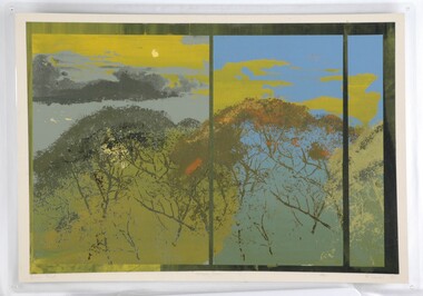
Print - Print - Urban Gums, 1984
CEMA Art Collection Part of "A Community View" 150 years in Portland Screenprint Exhibition Part of Angela Gee Residency 1983 ans 1984Laminated screenprint with three panels separated by a green border. The panels vary in size and are predominantly various shades of green. Within all panels the foreground illustrates gum tree foliage and the background shows a cloudy sky.Front: Artists Proof (lower left) Urban Gums (lower centre) R.Davies 84' (lower right) Back: 3 -
 Glenelg Shire Council Cultural Collection
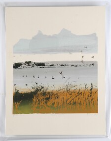
Print, Rex Davies, Urban Lagoon, 1984
CEMA Art Collection Part of "A Community View" 150 years in Portland Screenprint Exhibition Part of Angela Gee Residency 1983 and 1984Laminated screenprint with green and orange grassy foreground. Centre of image shows a grey body of water with black swans and ducks. Top half of work features a blue/grey cloud with ducks in flight on the right side.Front: Artists Proof (lower left) Urban Lagoon (lower centre) R. Davies '84 (lower right) Back: 4 -
 Greensborough Historical Society
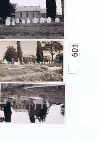
Photographs, St Katherine's Anglican Church St Helena 1930s, 19/03/1932
St Katherine's Church St Helena was built by Major Anthony Beale pioneer settler of the area, and named after his wife. The original church was damaged by fire in February 1957 and rebuilt shortly after. The accompanying article describes the "quaint old village of Greensborough" and an excursion to the churchyard at St Helena. Refer to article by Eileen Fortescue in The Argus Newspaper Saturday 19/3/1932 Page 8.These photos are significant as they were taken before the fire and there are few photographs of the original church. Set of 4 postcards (9x14cm), one photograph (10x16cm), one photograph (16x11cm). All show views of St Katherine's Church St Helena. Also an A4 copy of a magazine article about St Helena.Each image has a caption and date on the back.st katherines church, st helena, anthony beale, rose chapel -
Glenelg Shire Council Cultural Collection
Card - New Years Greeting Card, 01/1893
New Year's greeting card, bi-fold, front third scene of houses and trees, edges cut out, to show a flock of swallows, on the back section, middle third has a verse, by S.K. Cowan M.A.Front: 'A New Year of Joy and Peace be yours' Back: 'To Dear Clara from Maretimo January 1st 1893 -
Glenelg Shire Council Cultural Collection
Postcard - Postcard - Burswood House, Portland, n.d
Coloured postcard of 'Burswood' built in 1855 for Edward Henty. Shows front section of house and gardens, " 'Burswood' built in 1855 for Edward Henty" in black print, bottom border BURSWOOD - ROSE SERIES COLORVIEW NO. 1659Back: Marker's details and logo BURSWOOD - ROSE SERIES COLORVIEW NO. 1659postcard, portland, tourism -
Glenelg Shire Council Cultural Collection
Negative - Negative - View over Harbour, Portland Victoria, Zilah Maschmedt, 1961
Negative for a black and white photograph. Image shows view over Portland Harbour, Whalers Bluff and lighthouse, right foreground, Lee Breakwater, Ocean Pier, LS Anderson Wharf, Battery Point and Lawrence Rocks. -
Glenelg Shire Council Cultural Collection
Map - Map - Paper Survey, n.d
Paper survey map, ink and watercolour, framed under glass. Painted black gloss. Shows Fawthrop lagoon and surrounds including Fawthrop's home 'Windsor Cottage', outbuildings and garden, Cairncross and Howard holdings and othersBack: 'Town of Portland' -
Glenelg Shire Council Cultural Collection
Photograph - Sheet of 2 contact prints from glass plate negatives, 1960-1970
Sheet of 2 contact prints from glass plate negatives. Each print measures 12 x 16 cm Top: Crowd at Portland Show. Bottom: River flowing through heavily wooded banks. -
Glenelg Shire Council Cultural Collection
Photograph - Photograph - Portland Smelter, c. 1980
Previously displayed in offices at the smelterFramed aerial photograph of Portland smelter taken in 1908's. Image shows Dutton way and Narrawong in the background. Gilt wooden frame. Glass covers photo. Brown paper on back of photo, hanging cord.Front: Back- Label for Gary Hayman, picture framer -
Glenelg Shire Council Cultural Collection
Photograph - Photograph - Sailors, n.d
Black and white photo mounted on heavy card. Image shows a large group of sailors in uniform posed in front of wooden building. Officer standing on left. Dress estimated to be late 19th, earl 20th Century. -
 Halls Gap & Grampians Historical Society
Photograph - B/W, C 1960s
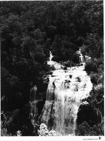
A Forestry Commission photo of MacKenzie Falls.Photo shows a large waterfall (MacKenzie Falls), taken from a fairly high vantage point. The river comes into the falls in two separate streams and there is a large volume of water flowing. The falls are surrounded by thick bush."Publicity & Public Relations branch. When reproducing please Acknowledge FORESTS COMMISSION, VICTORIA. Negative No. 322-2" stamped on rear (except negative number, which is hand written in pen)scenery, mackenzie falls -
 Halls Gap & Grampians Historical Society
Photograph - Coloured, C 2007
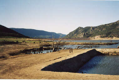
This is a photo of the exposed swimming pool of Myrtlebank, which became exposed in Lake Bellfield during the drought years (2007 - ). The view is looking towards the dam wall and further road through the valley..Photo shows an exposed swimming pool (Myrtlebank Pool) in a very low reservoir (Lake Bellfield). There are dead branches in the water behind the pool and the dam wall and former road through the valley can be seen in the background.recreation, swimming pool -
 Halls Gap & Grampians Historical Society
Photograph - B/W, C ?
This is the ford over the Stoney Creek and shelter shed.The photo shows a track leading down to a large pergola type structure, surrounded by thick bush. There is a tall gum on the right of the picture, beside the track. A large branch of a tree can be seen in the top left foreground.access routes, roads -
 Halls Gap & Grampians Historical Society
Photograph - B/W
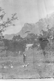
This is a pastoral scene in halls Gap. The building is the Halls Gap Public Hall.The photo shows a man with a hat and long walking stick standing in a paddock with a number of geese. In the middle distance is a building surrounded by fruit trees. Behind this tall eucalyptus trees can be seen and in the background is a rocky range.mining, equipmment -
 Halls Gap & Grampians Historical Society
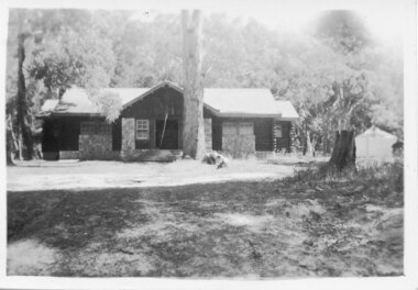
Photograph - B/W, C 1946
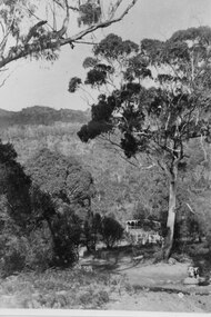
A photo of the Comfort Station in the Halls Gap Picnic and Camping Reserve.The photo shows a wood and stone building at the rear of a clearing with a large eucalyptus tree growing close to the front of it. In the background is heavy bush. A tent or large cloth can be seen on the right beside a large tree stump.buildings, mountain grand -
Halls Gap & Grampians Historical Society
Photograph - B/W, C 1900s
This is a photo of a woodchopping competition, a popular event at this time. The location is unknown, but it may have been the recreation area in Halls Gap.The photo shows five men standing on wood-chop blocks, all with axes in hand. In the foreground is a man sitting on the ground and discarded blocks, some numbered. Spectators can be seen in the background behind a wire fence.recreation, woodchopping competition