Showing 7692 items matching " canning "
-
 Mission to Seafarers Victoria
Photograph, New Year 1923 - Jules Michelet, 1923
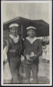
In January 1923, 5 years after the end of WWI, the two French cruisers Jules Michelet and Victor Hugo went on a tour in South East Asia, Australia and New Zealand consolidating the friendship between the countries. The cruisers arrived in January 1923 and Melbournians were invited to visit the ships. Amongst them the ladies from the Guild. In the "Jottings from Our Log"number 69 dated from January 1923 we can read: Our French Visitors The French cruisers, “Jules Michelet” and “Victor Hugo”, each with a complement of 26 officers and 747 men, paid a visit to this port towards the end of the year. Many of the sailors made good use of our institute, and were supplied with French magazines and papers, and were delighted to find that quite a number of ladies could speak French fluently. Over one hundred men were present at the Institute on one of our special nights during Christmas week, when each French visitor was supplied with refreshments and a cigar. Through the great kindness of some of our ladies, each man aboard the two cruisers was supplied with a packet of cigarettes. These were greatly appreciated by the men, and a warm letter of thanks was received from each of the captains."Reflects strong community and LHLG links via the Mission and as a result of WW1 support and fundraising efforts.Sepia tone blurry photograph with a white frame depicting two French seafarers with their traditional uniform and beret on shore near a pier shed children or women in the far distance at lwr right.Handwritten at the back in pencil: New Year 1923 Jules Micheletfrench cruiser, jules michelet, victor hugo, wwi -
 Eltham District Historical Society Inc
Photograph, Liz Pidgeon, Heritage Excursion; The 1901 Eltham Railway Walk, 3 May 2014, 3 May 2014
Newsletter No. 216, May 2014 May Excursion – The 1901 Eltham Railway Walk The railway from Heidelberg to Eltham was opened in 1902. Over the previous year railway construction cut a curving swathe through Josiah Holloway’s 1851 Little Eltham subdivision. The survey plans for the railway show the owners and occupiers of land within Little Eltham affected by the railway alignment and for some distance each side. The plans show houses and other buildings but development at that time was rather sparse. Copies of these plans from the State Library of Victoria collection have been provided to the Society by Alan Sheehan. For our walk on 3rd May we intend to follow the railway from the Eltham Station to Ryans Road, which was the boundary of the adjoining Montmorency Farm. The return will be by way of nearby streets. Along the way we will discuss the details shown on the railway plans as well as more recent railway documents and photographs. At the conclusion and if time permits we can inspect the historical display at the Eltham Station. The walk is about 3 km in length and will take about 2.5 hours. It will start at 2 pm at the Eltham Railway Station car park (east/Main Road side) (Melway Ref. 21 J5).Born Digitalheritage excursion, activities, eltham district historical society, eltham railway station, eltham library, trestle bridge -
 Eltham District Historical Society Inc
Negative - Photograph, Village Pond, near Main Road, Eltham, c.1908
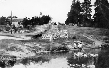
Village Pond, near Main Road, Eltham, c.1908 Reproduced on p57 of 'Pioneers & Painters'. Looking up Dalton Street from across Maria Street (Main Road), near Whitecloud (Jarrold’s cottage) and the Bootmaker’s cottage, to the left (out of view) of the photographer. The residence of the Head Teacher, Eltham State School No. 209, can be seen on the right, the Grant house on the left (site of present day Eltham Clinic). The willow trees south of Jarrold’s Cottage today mark the site of the old pond, which the Eltham Shire Council evidently filled in to stop mosquitos breeding. The pond and its locality was described in an article about Eltham published in The Australasian, May 2, 1903 - “There is the village pond (so essentially English), reflecting in its clear water a quaint cottage, dwarfed by a huge gum tree, an old smithy, and a hostelry, built quite fifty years ago, the flooring-boards of which the landlord informed me with pride were of Singapore cedar, and quite fit for another fifty years' wear. Then there are the village school, the shoemaker's, the drapery store, and the butcher's shop, all seemingly as they were when first they were erected many years ago.”This photo forms part of a collection of photographs gathered by the Shire of Eltham for their centenary project book,"Pioneers and Painters: 100 years of the Shire of Eltham" by Alan Marshall (1971). The collection of over 500 images is held in partnership between Eltham District Historical Society and Yarra Plenty Regional Library (Eltham Library) and is now formally known as the 'The Shire of Eltham Pioneers Photograph Collection.' It is significant in being the first community sourced collection representing the places and people of the Shire's first one hundred years.Digital image 4 x 5 inch B&W Neg Print 16.5 x 25 cm (2) and 9 x 12.5 cm Postcard 9 x 14 cmOn one print "57 and 11 3/8' x 10' deep"shire of eltham pioneers photograph collection, dalton street, duck pond, eltham, grant house, main road, maria street, village pond -
 Flagstaff Hill Maritime Museum and Village
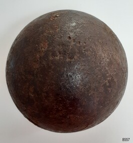
Weapon - Cannon Ball, Victorian era
This small cannon ball was found by the donor around 1975 to 1977 when he was digging a trench to install underground cables at the Warrnambool Surfside Caravan Park' Its location is just below both Cannon Hill and the 19th century Fortifications at Flagstaff Hill Maritime Museum and Village. The ball is made of iron. Cannon balls were used as ammunition for a cannon gun and fired at a target. This cannon ball is only 8 cm round, or 4.15 inches, and is likely to have been called a 4-pounder (4-pdr). The ball was made from molten iron was poured into the small opening of a two-piece mould. The seam between the moulds sometimes left a raised ring mark on the ball, as can be seen on this ball. The ridge would have been filed to make the join smooth, sometimes leaving a slightly flat area. Six 4-powder cannons were recovered from Endeavour Reef, Queensland, in 1969. They were from Captain Cook's HMS Endeavour, thrown overboard when the ship struck a reef there in 1770. They are likely to have been mounted on deck cannon carriages on the ship. Similar 4-pounder cannons were mounted on gun carriages and used as field guns. Cannons with cannon balls as ammunition were installed at Warrnambool for protection from possible invasion in the mid-to-late 19th century and early 20th century.Cannon ball, iron, black with a pitted shiny surface. It has three flat areas and evidence of a seam around the circumference. There are remnants of a possible inscription stamped into the iron. The cannon ball is a four-pounder ball. Imperial weight is 71 oz (201.3 gms or 4.44 pounds).Remnants of an indecipherable stamp and / or red text.flagstaff hill, flagstaff hill maritime museum and village, warrnambool, maritime museum, maritime village, great ocean road, shipwreck coast, cannon ball, ammunition, cannon, fortifications, military equipment, firearm, weapon, two-piece mould, seam line, four-pounder, 4-pounder, field gun, field ammunition, gun carriage, cast cannon ball -
 Federation University Historical Collection
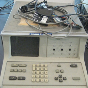
Equipment - Computer - Logic Analyzer, Hewlett Packard, Logic Analyzer 1615a
The Logic Analyser was purchased by the Ballarat College of Advanced Education Physics Department in the early 1980s. At the time it was a state of the art piece of test equipment used for fault finding and programming diagnostics for 8 bit computers. It was later used by the Electrical Engineers, after Physics merged with Engineering in the mid 1990s. The device monitored the 16 bit Address buss and 8 bit Data buss of an 8 bit computer. This device continually samples the 24 bits simultaneously and looks for a preset pattern. When the pattern is matched the logic analyser continues for a set number of steps thus allowing an operator to examine the data and address information both leading up to and after an event. This was particularly useful for diagnosing unusual programming and hardware errors. Logic analyzers are used in debugging and troubleshooting in mini- and microcomputers. The HP analyzers collect information through 24 (1615A) or 32 (1610B) inputs leads, connected to the computer's address, data and/or control lines. The logic state flow is shown on a display in a number of traces, a single data line or an appropriate combination of data lines providing a trigger signal. Captured data can be stored for detailed analysis. (http://http://www.science.uva.nl/museum/hp1610.php)Grey Analog computer. Includes keys and small screen.computer, logic analyzer, physics -
 Federation University Historical Collection
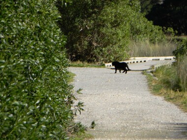
CD-ROM, Big Cats sightings in Victoria, 2012
The CD-Rom includes a range of electronic correspondence sent 'Big Cats Victoria and Simon Townsend and JohnTurner. Their website states: Big Cats Victoria Southern Australia, including south western West Australia, has a history of reports of ‘panther’ like predators dating back to the later half of the 19th century. The animals were usually described as being of black or tan colouration and with the proportions of a medium sized big-cat such as a Leopard or Puma. The records can be found in newspaper, radio and television archives, Government reports, a very few books and on the internet. The historical material is based on anecdotal reportage and has contributed to the mythification of the subject. Some Government agencies at both State and Local levels (in New South Wales), have collected records of sightings or investigated stock deaths purported to be associated with so called ‘panther’ kills. They remain understandably non committal due to the lack of a specimen of such a predator of undeniable authenticity. While other types of unknown predator have been reported in various parts of Australia they are not the concern of this website. For purposes of economy we, John Turner and Simon Townsend, confine our investigations to western Victoria and south eastern South Australia. (http://bigcatsvic.com.au/) A CD-ROM of multiple emails and image attachments relating to assorted sightings, footprints, killings, etc from big cats in the Otways of Victoria. The electronic mail was sent to 'Big Cats Victoria' Images include: This item is part of the Australian Animal Folklore Collectionaustralian animal folklore collection, ja sharp, simon townsend, neville bayley, st kilda, peter stefanis, toolangi, puma, tom daniel, footprint, pawprint, cryptozoology, rex gilroy, lancefield tiger, anglesea, berringa, matthew charles, jutin fitzclarence, harry carlin, patty smith, johannes beach, nerida, stirling ranges, daryl hardy, brook kelly, carl rose, ashley hall, jonathan smith, sally ballieu, lorraine balck, wayne bower, ian riordon, aleda turna, john turner, dave moyle, ben rayner, stewart leach, colin boord, sheryl mahoney, beech forest, otways, tooborac, geoff black, panther, brad blake, priscilla prescott, beau kapitiany, ramsay hosn, clare jones, darren guthrie, tallarook, josh fairway, linda wescon, lithgow, john turner, southern grampians -
 Federation University Historical Collection
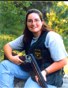
Photograph - colour, Nessa Jenkins
Nessa Jenkins was born at Ararat in 1980. She was a student of the University of Ballarat. At the 2002 Manchester Commonwealth Games Nessa Jenkins won the Women's Trap Pairs and was 5th in the Shooting Women's Trap. "At the 2002 Manchester Commonwealth Games Nessa Jenkins and Diane Reeves took gold from England by one point. The National Shooting Centre in Bisley provided the scene for some thrilling entertainment the Australian pair of Nessa Jenkins and Diane Reeves completed a hat trick of victories in world-class shooting events. Jenkins said: “I’m wrapped – the hardest thing is that you are trying to shoot your own score, but you’re still thinking about what your partner’s shooting, and I could hear Di calling for her targets. Sometimes you can hear the buzzer if someone misses and I didn’t hear it so I thought things were okay.” “We’ve had a lot of competition practice before coming to the Commonwealth Games – we’ve been to the World Cup and the World Championship so it’s been a big build up, but this just topped it off today.”(http://m2002.thecgf.com/Sports/Shooting/News/default.asp?id=579&folder=Shooting, accessed 07/08/2014) Colour photograph of Nessa Jenkins.jessa jenkins, commonwealth games, manchester, trap shooting -
 City of Moorabbin Historical Society (Operating the Box Cottage Museum)
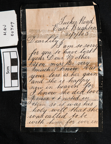
Documents, condolence letter 1903, 1903
A Letter of condolence sent to Lily (Elizabeth Ann Jones) for the death of her Mother, Mary Ann Jones, who died on 18 January 1903, from her school friend Jane Clark. Following Queen Victoria’s example, it became customary for families to go through elaborate rituals to commemorate their dead. This included wearing mourning clothes, having a lavish (and expensive) funeral, curtailing social behaviour for a set period of time, and erecting an ornate monument on the grave. . Relatives and friends were expected to give handwritten Condolence Cards and Letters, preferably by hand when visiting the bereaved. The different periods of mourning dictated by society were expected to reflect the natural period of grief. In recent years some traditions have given way to less strict practices, though many customs and traditions continue to be followed. Condolence Cards and Letters are still expected for relatives and close friends. These can be individually composed and handwritten or purchased from a Greeting Card Manufacturer. The letter shows Tucker Road as being in East Brighton. Due to the confusion caused by so many 'Brightons' in the area of Henry Dendy's Special Survey of 1841 this area was renamed Bentleigh after Sir Thomas Bent. The Clark family and the Jones family were early settlers in Moorabbin ShireWhite paper with a black border used for a hand written condolence letter sent by Mrs Jane Clark in 1903 during the mourning period for the mother of her school-friend Lily, (Elizabeth Ann Jones).market gardners, pioneers, early settlers, mooorabbin, brighton, east brighton, bentleigh, correspondence, writing equipment, pen and ink, clarke jane, clarke janet, mourning customs, bereavement, condolence letters, -
 Flagstaff Hill Maritime Museum and Village
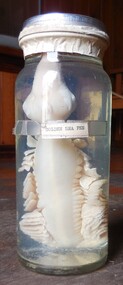
Animal specimen - Golden Sea Pen
The name 'Sea Pen', which name comes from its resemblance to bird feathers, originates from its more formal title of 'Pennatula'. There are various species, one of which (Phosphorea)is not uncommon at depths of 50 metres or more. It consists of a stalk by which the Sea Pen is probably fixed upright in the mud or sand, and of a fan like upper part. When alive it is brightly phosphorescent. The stalk is really a tube and can be inflated. The strands or polyps of the upper part of the creature are fused together in sets of a dozen or so, to form leaves up each side, somewhat like the barbs of a feather. The whole axis is supported by a firmly calcified internal stem. The preserved item in our collection has been bleached naturally in the preserving fluid over time. However the Sea Pen in this photograph is alive and displays as golden. It is positioned vertically with its stalk at the bottom and its fronds or feathers beautifully displayed along the upper part. The preserved item in our collection has been bleached naturally in the preserving fluid over time. However the Sea Pen in this photograph is alive and displays as golden. It is positioned vertically with its stalk at the bottom and its fronds or feathers beautifully displayed along the upper part.The use of such preserved specimens is widespread in teaching students of all ages, and museums of the composition of certain animals, insects, birds and sea creatures. Any information about an animal — be it photographs, blood, feathers or fur samples — is better than no information at all. But specimens are vital to ground-truth.Closed jar with an all white sea creature preserved in clear fluid. The head is uppermost, and the sea pen is positioned vertically in the jar.Golden Sea Penflagstaff hill, warrnambool, shipwrecked-coast, flagstaff-hill, flagstaff-hill-maritime-museum, maritime-museum, shipwreck-coast, flagstaff-hill-maritime-village, sea pen -
 Sunshine and District Historical Society Incorporated
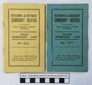
Membership Cards (1946), Sunshine & District Community Hospital, 30/09/1946
The hospital in King Edward Avenue Sunshine was originally known as St Andrew's Hospital and it was run by the Sisters Carruthers who in 1946 decided to retire. The hospital became the Sunshine & District Community Hospital on 15 September 1946. In the First Annual Report for the period 15 September 1946 to 30 June 1947, it is stated that of the 413 patients admitted 37.8% were members and 62.2% non members, and that the hospital was "...responsible for hospital attention under benefits to approximately 2000 residents." Just what the exact benefits were is unknown. Did members receive cheaper treatment, cheaper pharmaceuticals, guaranteed hospital bed, or something else? If anybody can provide the information it would be greatly appreciated. The 1946 cards show that L.W. Noble of Morris Street, Sunshine had a Single Membership which cost 26 shillings ($2.60) per annum, and that J.H.F Noble of the same address had a Double Membership which cost 39 shillings ($3.90) per annum. The cards were issued when payments for the first 4 weeks of membership were made, which were 2 shillings for Single and 3 shillings for Double. The stickers inside provide a record of continuing membership payments.These two cards indicate that membership of the Sunshine & District Community Hospital was a way of receiving Treatment or Membership benefits. This type of membership of a hospital appears to be a forerunner to the present day memberships provided by the various Hospital Benefits Associations. The cards also provide information about the cost of being a member of the Sunshine & District Community Hospital in 1946, and how the membership payments were recorded.The membership cards are actually small booklets with the Single Membership Card being Yellow coloured and the Double Membership Card being Blue coloured.Single Membership Card No. 983 / Double Membership Card No. 297 / Sunshine & District Community Hospital (Incorporated) / King Edward Avenue Sunshine / N.B.--This Card Must be submitted when requiring Treatment or Membership Benefitshospital membership card, sunshine & district community hospital, leslie noble, l.w. noble, j.h.f. noble, 94 morris street sunshine, king edward avenue sunshine, 30 september 1946, no. 983, no. 297, membership cards (1946) -
 Bendigo Historical Society Inc.
Slide - Dunn's Rock Eppalock, 2012
The low rolling hills of the Kimbolton countryside consist of ancient, hard and fractured Ordovician rock up to 65 million years old, which was originally deposited deep under the sea. Rocks mainly are sandstone, mudstone, black shale and quartz conglomerates. Marine fossils can be found in the area. Around seven million years ago a basalt flow buried the original bedrock along the along the Campaspe River. Ongoing weathering, wind and water movement over the following years has produced younger clay, sand, silt and gravel deposits throughout the area. Patches of White Hills Gravel are also found in the area. Another unique geological feature of this area is the Permian Glacial Pavement rocks north and south of Eppalock and glacial sediments (such as “Dunn’s Rock” and “Kellams Rock”). During the ice age (up to 280 million years ago) large glaciers moving over the countryside, scoured out sediments, pulverized bedrock, polished and cut grooves into bedrock in the direction of ice movement. When the ice melted boulders etc where left behind in areas of entirely different rock types, such as a 100 Tonne granite block known as ‘The Stranger’ near Derrinal. Dunn's Rock (Glaciated Pavement) Eppalock - Photos of the rock and a field group collecting date with Lake Eppalock (Knowsley) in the backgroundhistory, bendigo, dunn's rock eppalock, kimbolton forest, lake eppalock, gately collection -
 Kew Historical Society Inc
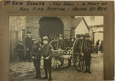
Photograph, 1st Kew Scouts Fire Drill, 1911, 1911
A Volunteer Fire Brigade was established in Kew in 1879 and a fire station established in Walton Street, Kew. The Brigade was formally disbanded by the Fire Brigade Act of 1890 and the volunteers replaced by a unit of the Metropolitan Fire Brigade in 1891. The building shown in this rare photograph was constructed in 1893. In the background can be seen a house on the corner of Walton and Peel Streets, one of two, built in 1893 for firemen of the Brigade. An article in The Weekly Times (1 April 1911) records that: "Kew Troop - A,S.M. Williams reports:- The troop under S.M. Kellett. marched to the Kew Fire Brigade station, to receive instruction in fire drill from Mr Gross, the officer in charge, but as he was unexpectedly called away, the S.M. S and A.S.M had to instruct the Troop. Every boy was taught how to sink the hydrant, and how to couple and uncouple the hose. The hose reel was then brought into action, and the boys were divided into sets of six, each division taking its turn in pulling the reel up a hill to the water plug, where the hydrant was quickly sunk by one Scout, two more uncoupling the hose and coupling it on to the hydrant. We have gained four recruits during the last week, and are expecting two more next week."This is a fine, original photograph, probably taken by a commercial photographer, showing the 1st Kew Scouts in front of the old Kew Fire Brigade building in Walton Street in 1911. The building, constructed in 1893 was later demolished in 1941. This is a rare historic photograph of the Station. Unfortunately the name of the photographer is unrecorded.1st Kew Scouts undertaking a fire drill in front of the old Kew Fire Station in Walton Street, Kew. The reverse details the names and addresses of the Scouts featured in the photograph. An integral part of the Scout program is service to others and working with the fire brigade would have been just one of many such training activities enthusiastically undertaken by the Scouts. The Kew Fire Brigade had hand-drawn fire appliances up until 1919 when a motorised vehicle was purchased. The fire station was replaced by the Belford Road station in 1941 and subsequently demolished. Front: "First Kew Scouts - Fire Drill - In front of Kew Fire Station - Walton St. Kew" Reverse: "Walton St Kew / Kew Fire Station / Mr Gross o/c Fire Station / Bert Gundy Clark, part-time fireman / Allan Sewell Gellibrand St. / Clappy Williams Hawthorn ? / Allan Barrett Cobden St / Allan Woollard High St"kew fire brigade - walton street, scout groups --- kew (vic), 1st kew boy scouts