Showing 10846 items
matching maps
-
 Stawell Historical Society Inc
Book - Research, Black Range
Families and settlements of Black Range - Newspaper articles, Memories of families, maps, Black range School recordsGreen 2 ring Binder. Paper in plastic insertsBlack Range -
 Whitehorse Historical Society Inc.
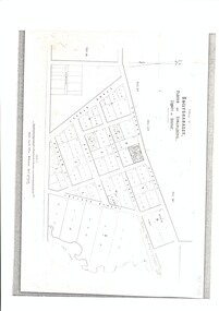
Map, Village of Ballyshanassy, 10 April 1858
A map of the Village of Ballyshanassy by the Public Lands Office, Melbourne. Scale 12 chains equals 5 cmsballyshanassy -
 Apollo Bay Museum
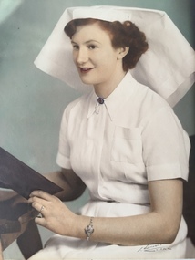
Film - Val Cameron on patient transport
Audio slideshow with Val Cameron's memories and photographs. Created as part of the Heart Maps project with Amy Tsilemanisapollo bay, nursing, patient transport -
 Apollo Bay Museum
Film - Val Flitton on family and early Apollo Bay days
Audio slideshow with Val Flitton's memories and photographs. Created as part of the Heart Maps project with Amy Tsilemanisapollo bay, oral history -
 Apollo Bay Museum
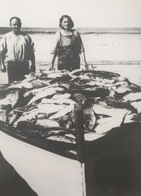
Film - Neville Fisk on fishing and family in Apollo Bay
Audio slideshow with Neville Fisk on fishing and family. Created as part of the Heart Maps project with Amy Tsilemanisapollo bay, fishing -
 Warrnambool and District Historical Society Inc.
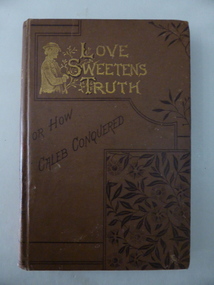
Booklet, Love sweetens truth, 1880s
This book was a prize awarded to Miss Middleton, a pupil at Ormiston House College, East Melbourne in 1887. The Principals of the school were the Misses Singleton and their father, Dr John Singleton was a practising doctor in Warrnambool from 1860 to 1865. He had an important influence on Warrnambool, establishing several Total Abstinence Societies and campaigning for improved health conditions for pastoral workers in the district and the aborigines at Framlingham. In Melbourne Dr Singleton and his wife worked tirelessly for the underprivileged. He established many institutions for the less fortunate, including the Prisoners’ Aid Society, the Children’s Hospital, lending libraries, cottages for widows, shelters for homeless men and women, a society for the protection of animals and the Collingwood Free Medical Dispensary. He died in 1891 at Ormiston House, his daughters’ school and home. It is not known which of the Singleton daughters ran the school and no information has been found on Miss Middleton. This book is of considerable interest as it has a close connection to Dr John Singleton, important not only in the social history of Melbourne but also in the history of Warrnambool. This is a hard cover book of 160 pages with 16 pages at the back of the book of advertisements for other books published by the Religious Tract Society. The cover is brown with a sketch of a young man and lettering in gold and an ornamental floral pattern on the front cover. The gold lettering and the ornamental floral pattern are also on the spine. The book has 13 chapters with ornamental scrolls and initials at the beginning and end of each chapter. There are also some full page black and white sketches in the book, with the one at the front of the book covered by a piece of tissue paper. The book plate at the front of the book is white with a gold border pasted onto the page and handwritten details have been added in black ink. The book is a little scuffed at the edges of the cover. ‘Ormiston House College, East Melbourne, Principals, The Misses Singleton, Prize for Writing and Maps in Upper Third Class Awarded to Miss Middleton, Christmas 1887.’ dr john singleton, ormiston house, history of warrnambool -
 Geelong RSL Sub Branch
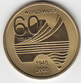
Medallion, circa 2005
The Australian Government provided the medallion to commemorate the 60th Anniversary of the end of WW 2.The medallions were distributed to all surviving veterans, widows and widowers.Gold coloured round medallion.On the front - World War 11 60 years 1945-2005, map of Australia. On the Back - World War 11 Service to Australia, the Australian Coat of Arms.ww2, veterans, 60th anniversary medallion -
 Ballarat Tramway Museum
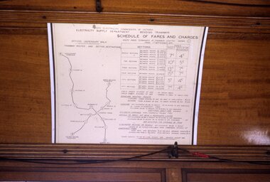
Slide - 35mm slide/s, Peter Moses, Jan. 1969
Photo of the SEC Bendigo "Schedule of Fares and Charges" inside a tram. The fare chart appears to have been mounted on a large sheet of white cardboard. Note the red tape joining the bell cord. Kodak cardboard mount slide, taken by Peter Moses, Jan. 1969.On the rear of the slide "Jan. 1969 Bendigo/ Map of Routes" in blue ink, "P. Moses" in black ink and other side of the slide in red ink “1”.tramways, trams, bendigo, schedule of fares, map, fares -
 City of Moorabbin Historical Society (Operating the Box Cottage Museum)
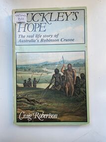
Book, Globe Press Pty. Ltd, Buckley's hope : the story of Australia's wild white man, 1981
A small soft cover book with a blue/green cover,on the front cover is a painting of early Australia with Indigenous Australians hunting with spears alongside them is a European with long unkept hair and a beard dressed in animal skins,on the back cover is text by the author giving a brief outline of the book.buckley, sorrento, robinson crusoe, port phillip, van diemen's land, colonialism, 1840, convicts, indigenous tribes. -
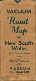 Bendigo Historical Society Inc.
Document - BILL ASHMAN COLLECTION: VACUUM ROAD MAP OF NEW SOUTH WALES
Vacuum Road Map of New South Wales with Interstate Routes with the Compliments of the Vacuum Oil Company Pty. Ltd. Coloured map of NSW with car, trucks, aeroplane and petrol bowsers around the margin. Has a list of principal Towns and Distances from Sydney. On the back is Beauty Spots around Sydney, Traffic Hints, Sydney-Melbourne Routes, Short Tours Around Sydney, Outlets of Sydney, Canberra and Newcastle, What to See in Sydney, Vacuum Products, Making Sure of a Trouble-Free Trip, Super Plume or Plume and the front picture of the folded map which has a car with a lady, child and a man at the petrol bowser. Map folds up and has a brown card pocket to keep it in.map, bill ashman collection - correspondence, vacuum road map of new south wales, vacuum oil company pty ltd, clive barass -
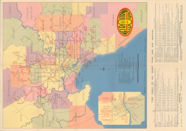 Melbourne Tram Museum
Map, Melbourne & Metropolitan Tramways Board (MMTB), "Map and timetable of Melbourne Tram and Bus Services" - March 1952", Mar. 1952
Fold out map (10 sections), coloured of Melbourne's Tram and Bus routes, route numbers, rail lines, municipalities boundaries and location of major places of interest. Titled - "Map and timetable of Melbourne Tram and Bus Services" - May 1952". At base of map - timetable of all night trams and bus services. On rear index to routes, 1st and last services, time of Sunday am services, Latrobe St. services and photo of Wattle Park. Dated March 1952 - Bourke St shown as bus. See Reg Item 413 for the May 1956 version. Very high resolution scans held. See also Reg Item 3720 for a MMTB Map of the same era.trams, tramways, melbourne, map, tram & bus services, all night services, mmtb -
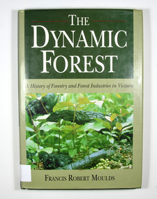 Marysville & District Historical Society
Book - Hardback book, The Dynamic Forest-A History of Forestry and Forest Industries in Victoria, 1991
A history of forestry and forest industries in VictoriaHardback. Green dust cover with photograph of forest undergrowth. Front end paper shows a map of Victoria detailing forested and non-forested areas in the State of Victoria in the year 1869. Back end paper shows a map of Victoria detailing forested and non-forested areas in the State of Victoria in the year 1987. To Jean, who bore the/ brunt of it all - and to/ Jan, Rob, Sue and Andy Stamp of the Marysville & District Historical Society Inc / P.O. Box 22 / Marysville 3779forests, forestry, forest products industry, victoria, history, moulds, francis robert -
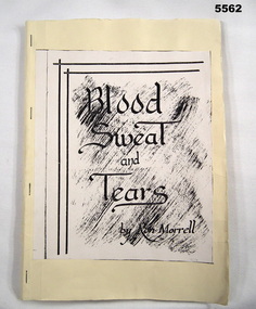 Bendigo Military Museum
Book, Blood, Sweat and Tears
Diary outlining History of Service in WW2 of Ron Morrell No.4985826 1/5 Sherwood Foresters, 18th Division. Joined in England and posted to Singapore where captured as POW and was at Changi. Diary was written in 1986. He later migrated to Australia. Refer Cat No. 316, 305P for details.Home made book of the Diary of Ron Morrell, from enlistment through being a Prisoner of War to discharge. Yellow cardboard cover with title sheet glued on front. Four staples and 45 pages inside contain maps and history of service, all handwritten with some maps and sketches all in black and white.Title on front "Blood, Sweat and Tears by Ron Morrell". Contents are all handwritten.diary, changi, ww2, pow -
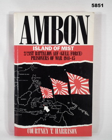 Bendigo Military Museum
Book - BOOK, WW2, Courtney T. HARRISON, "Ambon, Island of Mist", 1989 Reprint
Owner and donor details - see Cat No. 5836.3,Soft cover book. Cover - cardboard, black and white colour print on front, spine and back. Background, white, red and black. Illustrated map, South East Asia and three red, and white flags. 262 pages - cut, plain, white paper. Illustrated black and white photographs, maps and drawings.books, military history, ww2, pow's -
Glenelg Shire Council Cultural Collection
Decorative object - Badge - Fish Holes Rally 1987, Portland, Victoria, c. 1987
Fish Holes Rally badge, 1987. cream enamel and gold coloured badge. Image of motor bike superimposed on outline map of Victoria, 'Portland' marked on map. 'FISH HOLES RALLY' around top curve of badge. '1987' in gold frame bottom curve of badge. Eyelet each side of badge. -
 Bendigo Historical Society Inc.
Map - STATE RIVERS AND WATER COMMISSION : COLIBAN DISTRICT IRRIGATION AND TOWN SUPPLY CHANNELS, 30/11/1956
State Rivers and Water Supply Commission. Foolscap-size map. Title : Coliban district Plan showing Irrigation and Town Supply Channels. The map covers the area from Raywood to Guildford. Scale : 1 inch to 4 miles. Dated 30/11/56, number 5,491 in bottom right corner.state infrastructure, water supply, coliban system, state rivers and water supply commission. coliban system. -
Bendigo Historical Society Inc.
Map - CAMPBELL COLLECTION: BENDIGO AND DISTRICT MAPS, 8-6 29
Map. Kimbolton, Parishes of Kimbolton and Lyell, scale 20 chains to 1 inch. Area by Plamimeter 6258 acres. Coliban River, Knowsley, Strathfieldsaye 10 1/2 miles. Prepared in W.P.B. from Parish and Assessor's Plans. G.W.Latimer 8-6-29. (number 393 in map cupboard 1)G.W.Latimermap, bendigo, allotments -
Bendigo Historical Society Inc.
Map - CAMPBELL COLLECTION: BENDIGO AND DISTRICT MAPS, 16-4-29
Map. Kennington, Parishes of Sandhurst, Mandurang and Strathfieldsaye. Scale 20 chains to 1 inch. Total area 2918 acres. Bendigo 2 1/2 miles. Prepared in W.B. from A.and C. L. Plans by W.J. Galbraith, 16-4-29. (number 364 in map cupboard 1)W.J.Galbraithmap, bendigo, allotments -
Bendigo Historical Society Inc.
Map - FRED COWIE COLLECTION: AERIAL MAPS OF HEATHCOTE/EPPALOCK, 28-9-1960
Map, Heathcote C2, Township of Heathcote, Melbourne Road through town branching off to Bendigo & Echuca. Aerial Survey of Victoria. Photo-map prepared by Department of Crown Lands and Survey from photographs taken in 1960. Copied photographically at the Central Plan Office.Fred Cowie,46 McIvor Rd,Bgo..Central Plan Officemap -
Bendigo Historical Society Inc.
Map - CAMPBELL COLLECTION: BENDIGO AND DISTRICT MAPS, March 1947
Map. Mandurang, County of Bendigo, Sandhurst, Strathfieldsaye, Sedgwick, Sutton Grange, Ravenswood, Lockwood. Scale 40 chains to 1 inch. Drawn and reproduced at the Department of Lands and Survey, Melbourne, March 1947, price 2/-. By Authority : J.J. Gourley, Government Printer, Melbourne. (number 402 in map cupboard 1)J.J. Gourley, Government Printer.map, bendigo, allotments -
Bendigo Historical Society Inc.
Map - CAMPBELL COLLECTION: BENDIGO AND DISTRICT MAPS, August 1952
Map. Nerring, County of Bendigo, Yarraberb, Neilborough, Leichardt, Marong, Sandhurst, Huntly. Scale 20 chains to 1 inch. Drawn and reproduced at the Department of Lands and Survey, Melbourne, Victoria, August 1952. Price 2/-. By Authority J.J. Gourley, Government Printer, Melbourne. (number 404 in map cupboard 1)J.J. Gourley, Government Printermap, bendigo, allotments -
Bendigo Historical Society Inc.
Map - CAMPBELL COLLECTION: BENDIGO AND DISTRICT MAPS, 1963
Map. Sedgwick, County of Bendigo. Scale 20 chains to 1 inch. Strathfieldsaye, Eppalock, Lyell, Mandurang, Sutton Grange, County of Talbot. By Authority A.C. Brooks,Government Printer, Melbourne. Drawn and reproduced at the Department of Lands and Survey, Melbourne.1963. Price 2/-. (number 405 in map cupboard 1)A.C. Brooks, Governmenr Printer, Melbourne.map, bendigo, allotments -
Bendigo Historical Society Inc.
Map - WOODSTOCK : COUNTY OF BENDIGO, 4-7-35
Map. Woodstock, County of Bendigo, Derby, Leichardt, Marong, Shelbourne, Laanecoorie, Tarnagulla. Bradford Creek, Maldon and Laanecoorie Railway. Drawn and reproduced at the Department of Lands and Survey, Melbourne, Victoria.4-7-35. Price 2/-. By authority H.J. Green,Govt. Printer. (number 41 in map cupboard 1)H.J. Green, Govt. Printer.map, bendigo, woodstock -
Bendigo Historical Society Inc.
Map - ELLESMERE, COUNTY BENDIGO, 17-3-16
Map, Ellesmere, County Bendigo, Goornong, Bagshot, Muskerry, Wellsford, Axedale, Township of Fosterville.Campaspe River, Bendigo Creek, Railway Line.Photographed at the Dept. of Lands and Survey, Melbourne by W.J.Butson 17-3-16.Price 1/-. By authority Albert J.Mullett, Government Printer, Melbourne. ( number 38 in Map Cupboard 1)Albert J.Mullett, Govt. Printer, Melbourne.map, bendigo, ellesmere -
Bendigo Historical Society Inc.
Map - RUNNYMEDE : COUNTY OF BENDIGO, 8-12-13
Map. County of Bendigo, County of Rodney, Burnewang, Elmore, Nolan, Campaspe, Colbinabbin, Burramboot, Corop, Township of Runnymede, Campaspe River, Mount Pleasant Creek. Photo-Lithographed at the Department of Lands and Survey, Melbourne by W.J. Butson.8-12-13. Price 1/-. (number 107 in map cupboard 1)W.J. Butsonmap, bendigo, runnymede -
Bendigo Historical Society Inc.
Map - TOOLLEEN : COUNTY OF BENDIGO, 25-5-26
Map. Toolleen, County of Bendigo, County of Rodney, Campaspe, Colbinabbin, Cornella, Crosbie, Muskerry, Mount Pleasant Creek, Township of Toolleen. By authority H.J. Green, Govt. Printer. Photo-Lithographed at the Department of Lands and Survey, Melbourne by W.J. Butson, 25-5-26. (number 106 in map cupboard 1)H.J. Green, Govt. Printermap, bendigo, toolleen -
Bendigo Historical Society Inc.
Map - TOOLLEEN : COUNTY OF BENDIGO, 25-5-26
Map. Toolleen, County of Bendigo, County of Rodney, Campaspe, Colbinabbin, Cornella, Crosbie, Muskerry, Mount Pleasant Creek, Township of Toolleen. By authority H.J. Green, Govt. Printer. Photo-Lithographed at the Department of Lands and Survey, Melbourne by W.J. Butson, 25-5-26. (number 105 in map cupboard 1)H.J. Green, Govt. Printer.map, bendigo, toolleen -
Bendigo Historical Society Inc.
Map - COSTERFIELD : COUNTY OF BENDIGO, 29-10-29
Map. Costerfield, County of Bendigo, Counties of Dalhousie & Rodney, Dargile, Moormbool West, Warrowitue, Heathcote, Town of Costerfield, Dalhousie. By Authority H.J. Green, Government Printer, Melbourne. Drawn and reproduced at the Department of Lands and Survey, Melbourne. 29-10-29. Price 2/-. (number 92 in map cupboard 1)H.J. Green, Government Printer, Melbourne.map, bendigo, costerfield -
Bendigo Historical Society Inc.
Map - POMPAPIEL : COUNTY OF BENDIGO, 1-10-27
Map. Pompapiel, County of Bendigo, Calivil, Janiember East, Yarrayne, Salisbury, Yallook, Talambe, Judyong Creek, Bullock Creek, Pompapiel Creek, Edeyrn Estate. Photo-Lithographed at the Department of Lands and Survey, Melbourne by W.J. Butson, 1-10-27, Price 1/-. (number 4 in map cupboard 1)W.J. Butson, Government Printermap, bendigo, pompapiel -
 Ringwood RSL Sub-Branch
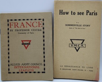
Documents WW1, C WW1
1040.1 Map of London for sailors and soldiers (produced by the YMCA).1040.2 London Omnibus map 1040.3 YMCA Guide to France 1040.4 How to see Paries (as recommended by the YMCA) 1040.5 Penny Guide of Stratford-On-Avon 1040.6 The tramway Guide to Glasgow 1040.7 Silk ribbon Overseas Christmas Greeting 1918.