Showing 10415 items
matching sections
-
 Eltham District Historical Society Inc
Photograph, Liz Pidgeon, Heritage Excursion; Maroondah Aqueduct, 3 September 2016, 3 September 2016
Newsletter No., 229, August 2016 Heritage Excursion - Maroondah Aqueduct Walk - Saturday 3rd September The Maroondah Aqueduct was once a major link in Melbourne’s water supply system. It was built between 1886 and 1891 to transfer water from the Watts River near Healesville to the Preston Reservoir. It was 66 km in length, made up of 41 km of open channel, 10 km of tunnel through hills and 15 km of pipeline across stream valleys known as inverted siphons. The section of the aqueduct through the Eltham area has been abandoned since the 1980s but the open channel has largely been retained. A recreational path follows the aqueduct reserve. For our excursion on 3rd September we intend to walk along the section of the aqueduct adjacent to Allendale Road. This is a section not visited on previous excursions and includes the transition from open channel to the inverted siphon across the Diamond Creek valley. Apart from the aqueduct itself the main feature of the walk is the extensive views across Eltham North and Diamond Creek. Along the way we will talk about the history of the aqueduct and the area. This easy walk is about 3 km return and will take 2 to 2.5 hours. It will start at 2pm at the junction of Allendale Road with Godber Road and Zig Zag Road North, officially Diamond Creek, but on the northern boundary of Eltham. (Melway ref.12 B10). Born Digitalmaroondah aqueduct, eltham north, activities, eltham district historical society, heritage excursion, aqueduct trail, open channel -
 Eltham District Historical Society Inc
Photograph, Liz Pidgeon, Heritage Excursion; Maroondah Aqueduct, 3 September 2016, 3 September 2016
Newsletter No., 229, August 2016 Heritage Excursion - Maroondah Aqueduct Walk - Saturday 3rd September The Maroondah Aqueduct was once a major link in Melbourne’s water supply system. It was built between 1886 and 1891 to transfer water from the Watts River near Healesville to the Preston Reservoir. It was 66 km in length, made up of 41 km of open channel, 10 km of tunnel through hills and 15 km of pipeline across stream valleys known as inverted siphons. The section of the aqueduct through the Eltham area has been abandoned since the 1980s but the open channel has largely been retained. A recreational path follows the aqueduct reserve. For our excursion on 3rd September we intend to walk along the section of the aqueduct adjacent to Allendale Road. This is a section not visited on previous excursions and includes the transition from open channel to the inverted siphon across the Diamond Creek valley. Apart from the aqueduct itself the main feature of the walk is the extensive views across Eltham North and Diamond Creek. Along the way we will talk about the history of the aqueduct and the area. This easy walk is about 3 km return and will take 2 to 2.5 hours. It will start at 2pm at the junction of Allendale Road with Godber Road and Zig Zag Road North, officially Diamond Creek, but on the northern boundary of Eltham. (Melway ref.12 B10). Born Digitalmaroondah aqueduct, eltham north, activities, eltham district historical society, heritage excursion, aqueduct trail -
 Eltham District Historical Society Inc
Photograph, Liz Pidgeon, Heritage Excursion; Maroondah Aqueduct, 3 September 2016, 3 September 2016
Newsletter No., 229, August 2016 Heritage Excursion - Maroondah Aqueduct Walk - Saturday 3rd September The Maroondah Aqueduct was once a major link in Melbourne’s water supply system. It was built between 1886 and 1891 to transfer water from the Watts River near Healesville to the Preston Reservoir. It was 66 km in length, made up of 41 km of open channel, 10 km of tunnel through hills and 15 km of pipeline across stream valleys known as inverted siphons. The section of the aqueduct through the Eltham area has been abandoned since the 1980s but the open channel has largely been retained. A recreational path follows the aqueduct reserve. For our excursion on 3rd September we intend to walk along the section of the aqueduct adjacent to Allendale Road. This is a section not visited on previous excursions and includes the transition from open channel to the inverted siphon across the Diamond Creek valley. Apart from the aqueduct itself the main feature of the walk is the extensive views across Eltham North and Diamond Creek. Along the way we will talk about the history of the aqueduct and the area. This easy walk is about 3 km return and will take 2 to 2.5 hours. It will start at 2pm at the junction of Allendale Road with Godber Road and Zig Zag Road North, officially Diamond Creek, but on the northern boundary of Eltham. (Melway ref.12 B10). Born Digitalmaroondah aqueduct, eltham north, activities, eltham district historical society, heritage excursion, aqueduct trail, open channel, pipe -
 Eltham District Historical Society Inc
Photograph, Liz Pidgeon, Heritage Excursion; Maroondah Aqueduct, 3 September 2016, 3 September 2016
Newsletter No., 229, August 2016 Heritage Excursion - Maroondah Aqueduct Walk - Saturday 3rd September The Maroondah Aqueduct was once a major link in Melbourne’s water supply system. It was built between 1886 and 1891 to transfer water from the Watts River near Healesville to the Preston Reservoir. It was 66 km in length, made up of 41 km of open channel, 10 km of tunnel through hills and 15 km of pipeline across stream valleys known as inverted siphons. The section of the aqueduct through the Eltham area has been abandoned since the 1980s but the open channel has largely been retained. A recreational path follows the aqueduct reserve. For our excursion on 3rd September we intend to walk along the section of the aqueduct adjacent to Allendale Road. This is a section not visited on previous excursions and includes the transition from open channel to the inverted siphon across the Diamond Creek valley. Apart from the aqueduct itself the main feature of the walk is the extensive views across Eltham North and Diamond Creek. Along the way we will talk about the history of the aqueduct and the area. This easy walk is about 3 km return and will take 2 to 2.5 hours. It will start at 2pm at the junction of Allendale Road with Godber Road and Zig Zag Road North, officially Diamond Creek, but on the northern boundary of Eltham. (Melway ref.12 B10). Born Digitalmaroondah aqueduct, eltham north, activities, eltham district historical society, heritage excursion, aqueduct trail -
 Eltham District Historical Society Inc
Photograph, Liz Pidgeon, Heritage Excursion; Maroondah Aqueduct, 3 September 2016, 3 September 2016
Newsletter No., 229, August 2016 Heritage Excursion - Maroondah Aqueduct Walk - Saturday 3rd September The Maroondah Aqueduct was once a major link in Melbourne’s water supply system. It was built between 1886 and 1891 to transfer water from the Watts River near Healesville to the Preston Reservoir. It was 66 km in length, made up of 41 km of open channel, 10 km of tunnel through hills and 15 km of pipeline across stream valleys known as inverted siphons. The section of the aqueduct through the Eltham area has been abandoned since the 1980s but the open channel has largely been retained. A recreational path follows the aqueduct reserve. For our excursion on 3rd September we intend to walk along the section of the aqueduct adjacent to Allendale Road. This is a section not visited on previous excursions and includes the transition from open channel to the inverted siphon across the Diamond Creek valley. Apart from the aqueduct itself the main feature of the walk is the extensive views across Eltham North and Diamond Creek. Along the way we will talk about the history of the aqueduct and the area. This easy walk is about 3 km return and will take 2 to 2.5 hours. It will start at 2pm at the junction of Allendale Road with Godber Road and Zig Zag Road North, officially Diamond Creek, but on the northern boundary of Eltham. (Melway ref.12 B10). Born Digitalmaroondah aqueduct, eltham north, activities, eltham district historical society, heritage excursion, aqueduct trail, russell yeoman -
 Eltham District Historical Society Inc
Photograph, Liz Pidgeon, Heritage Excursion; Maroondah Aqueduct, 3 September 2016, 3 September 2016
Newsletter No., 229, August 2016 Heritage Excursion - Maroondah Aqueduct Walk - Saturday 3rd September The Maroondah Aqueduct was once a major link in Melbourne’s water supply system. It was built between 1886 and 1891 to transfer water from the Watts River near Healesville to the Preston Reservoir. It was 66 km in length, made up of 41 km of open channel, 10 km of tunnel through hills and 15 km of pipeline across stream valleys known as inverted siphons. The section of the aqueduct through the Eltham area has been abandoned since the 1980s but the open channel has largely been retained. A recreational path follows the aqueduct reserve. For our excursion on 3rd September we intend to walk along the section of the aqueduct adjacent to Allendale Road. This is a section not visited on previous excursions and includes the transition from open channel to the inverted siphon across the Diamond Creek valley. Apart from the aqueduct itself the main feature of the walk is the extensive views across Eltham North and Diamond Creek. Along the way we will talk about the history of the aqueduct and the area. This easy walk is about 3 km return and will take 2 to 2.5 hours. It will start at 2pm at the junction of Allendale Road with Godber Road and Zig Zag Road North, officially Diamond Creek, but on the northern boundary of Eltham. (Melway ref.12 B10). Born Digitalmaroondah aqueduct, eltham north, activities, eltham district historical society, heritage excursion, aqueduct trail -
 Eltham District Historical Society Inc
Photograph, Liz Pidgeon, Heritage Excursion; Maroondah Aqueduct, 3 September 2016, 3 September 2016
Newsletter No., 229, August 2016 Heritage Excursion - Maroondah Aqueduct Walk - Saturday 3rd September The Maroondah Aqueduct was once a major link in Melbourne’s water supply system. It was built between 1886 and 1891 to transfer water from the Watts River near Healesville to the Preston Reservoir. It was 66 km in length, made up of 41 km of open channel, 10 km of tunnel through hills and 15 km of pipeline across stream valleys known as inverted siphons. The section of the aqueduct through the Eltham area has been abandoned since the 1980s but the open channel has largely been retained. A recreational path follows the aqueduct reserve. For our excursion on 3rd September we intend to walk along the section of the aqueduct adjacent to Allendale Road. This is a section not visited on previous excursions and includes the transition from open channel to the inverted siphon across the Diamond Creek valley. Apart from the aqueduct itself the main feature of the walk is the extensive views across Eltham North and Diamond Creek. Along the way we will talk about the history of the aqueduct and the area. This easy walk is about 3 km return and will take 2 to 2.5 hours. It will start at 2pm at the junction of Allendale Road with Godber Road and Zig Zag Road North, officially Diamond Creek, but on the northern boundary of Eltham. (Melway ref.12 B10). Born Digitalmaroondah aqueduct, eltham north, activities, eltham district historical society, heritage excursion, aqueduct trail, open channel -
 Eltham District Historical Society Inc
Photograph, Liz Pidgeon, Heritage Excursion; Maroondah Aqueduct, 3 September 2016, 3 September 2016
Newsletter No., 229, August 2016 Heritage Excursion - Maroondah Aqueduct Walk - Saturday 3rd September The Maroondah Aqueduct was once a major link in Melbourne’s water supply system. It was built between 1886 and 1891 to transfer water from the Watts River near Healesville to the Preston Reservoir. It was 66 km in length, made up of 41 km of open channel, 10 km of tunnel through hills and 15 km of pipeline across stream valleys known as inverted siphons. The section of the aqueduct through the Eltham area has been abandoned since the 1980s but the open channel has largely been retained. A recreational path follows the aqueduct reserve. For our excursion on 3rd September we intend to walk along the section of the aqueduct adjacent to Allendale Road. This is a section not visited on previous excursions and includes the transition from open channel to the inverted siphon across the Diamond Creek valley. Apart from the aqueduct itself the main feature of the walk is the extensive views across Eltham North and Diamond Creek. Along the way we will talk about the history of the aqueduct and the area. This easy walk is about 3 km return and will take 2 to 2.5 hours. It will start at 2pm at the junction of Allendale Road with Godber Road and Zig Zag Road North, officially Diamond Creek, but on the northern boundary of Eltham. (Melway ref.12 B10). Born Digitalmaroondah aqueduct, eltham north, activities, eltham district historical society, heritage excursion -
 Eltham District Historical Society Inc
Photograph, Liz Pidgeon, Heritage Excursion; Maroondah Aqueduct, 3 September 2016, 3 September 2016
Newsletter No., 229, August 2016 Heritage Excursion - Maroondah Aqueduct Walk - Saturday 3rd September The Maroondah Aqueduct was once a major link in Melbourne’s water supply system. It was built between 1886 and 1891 to transfer water from the Watts River near Healesville to the Preston Reservoir. It was 66 km in length, made up of 41 km of open channel, 10 km of tunnel through hills and 15 km of pipeline across stream valleys known as inverted siphons. The section of the aqueduct through the Eltham area has been abandoned since the 1980s but the open channel has largely been retained. A recreational path follows the aqueduct reserve. For our excursion on 3rd September we intend to walk along the section of the aqueduct adjacent to Allendale Road. This is a section not visited on previous excursions and includes the transition from open channel to the inverted siphon across the Diamond Creek valley. Apart from the aqueduct itself the main feature of the walk is the extensive views across Eltham North and Diamond Creek. Along the way we will talk about the history of the aqueduct and the area. This easy walk is about 3 km return and will take 2 to 2.5 hours. It will start at 2pm at the junction of Allendale Road with Godber Road and Zig Zag Road North, officially Diamond Creek, but on the northern boundary of Eltham. (Melway ref.12 B10). Born Digitalmaroondah aqueduct, eltham north, activities, eltham district historical society, heritage excursion, aqueduct trail -
 Eltham District Historical Society Inc
Photograph, Liz Pidgeon, Heritage Excursion; Maroondah Aqueduct, 3 September 2016, 3 September 2016
Newsletter No., 229, August 2016 Heritage Excursion - Maroondah Aqueduct Walk - Saturday 3rd September The Maroondah Aqueduct was once a major link in Melbourne’s water supply system. It was built between 1886 and 1891 to transfer water from the Watts River near Healesville to the Preston Reservoir. It was 66 km in length, made up of 41 km of open channel, 10 km of tunnel through hills and 15 km of pipeline across stream valleys known as inverted siphons. The section of the aqueduct through the Eltham area has been abandoned since the 1980s but the open channel has largely been retained. A recreational path follows the aqueduct reserve. For our excursion on 3rd September we intend to walk along the section of the aqueduct adjacent to Allendale Road. This is a section not visited on previous excursions and includes the transition from open channel to the inverted siphon across the Diamond Creek valley. Apart from the aqueduct itself the main feature of the walk is the extensive views across Eltham North and Diamond Creek. Along the way we will talk about the history of the aqueduct and the area. This easy walk is about 3 km return and will take 2 to 2.5 hours. It will start at 2pm at the junction of Allendale Road with Godber Road and Zig Zag Road North, officially Diamond Creek, but on the northern boundary of Eltham. (Melway ref.12 B10). Born Digitalmaroondah aqueduct, eltham north, activities, eltham district historical society, heritage excursion, aqueduct trail -
 Melbourne Tram Museum
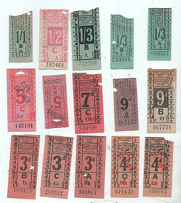
Ephemera - Set of 15 pre-decimal or imperial tram tickets, Melbourne & Metropolitan Tramways Board (MMTB)
Set of tickets - late 1940s early 1950s. All numbers in black, all printed in black unless noted otherwise. 1 - 3d light red No. 088137 with advert for Davis Gelatine cookery book and a schoolboy howler "The Crusades were fought in plasticine" 2 - ditto No. 283521 with advert for Stamina trousers on the rear 3 - ditto No. 303817 with advert for Shuron-Austral opticians 4 - two 4d City Section, Nos 430965 and 971649, fawn paper, overprinted in red with Stamina Trousers on rear 5 - 5d City Section, pink paper, red price with black over printing, No. 143181 with Stamina Trousers on rear 6 - 5d City Section, small, red paper, red price with black over printing, No. 143181 with Stamina Trousers on rear 7 - 7d, orange paper No. 844808 with Stamina Trousers advert on rear 8 - 9d, purple paper No. 287155 9 - 9d off white paper, reverse price No. 967758 with Snows Stamina Centre advert on rear. 10 - 1/1d green paper, No. 644123 small size with Stamina Trousers advert on rear 11 - 1/2d pink on off white paper, reverse price No. 167414 with Stamina Trousers on rear 12 - 1/3d on green paper reverse price No. 722796 with Snows Stamina Centre advert on rear. 13 - Two 1/3d on green paper, small size, No. 240955 and 893557Demonstrates tickets used by the MMTB some with the price in reverse printing.Set of 15 tram/bus tickets - paper flimsy - various colours and denominations, some with advertising on the rear.tramways, tickets, mmtb, stamina trousers, snows, davis gelatine, shuron-austral -
 Bendigo Military Museum
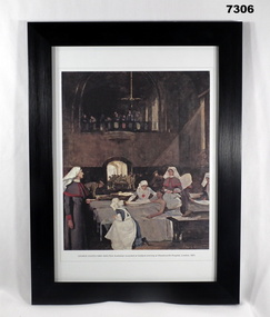
Print - PRINT, FRAMED WW1, Reader's Digest (Australia) Pty Limited, 2015
From information book - "Reader's Gigest/ Gallipoli/ 25th Aril 1915 - 9th January 1916/ Centenary Commemorative Prints". Collection of 20 prints Refer Cat No. 7300.Framed print. Print - colour print on paper. Copy of an oil on canvas painting. Depicts a "Hospital ward where several nurses attend a patient in bed", against a background of "beds being made ready in the ward" and "Stretcher bearers carrying in more wounded". Frame - black plastic framing with glass front and MDF board backing with adhered black paper.Details below print - in black ink. "GEORGE COATES (1869 - 1930). First Australian wounded at Gallipoli arriving at Wandsworth Hospital, London". 1921. "Served with the Royal Army Medical Corps at 3rd London General Hospital at Wandsworth". 1919 Commissioned to do portrait work for the Australian War Records section. framed accessories, pprints, ww1, gallipoli, centenary -
 Eltham District Historical Society Inc
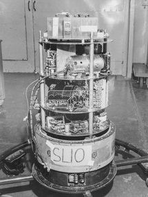
Photograph - Black and White Print, Weapons Research Establishment (WRE), Nose Cone - Skylark Rocket, 17 June, 1960
On reverse: Nose Cone - Skylark Rocket Also stamped in blue ink: Phone: Ex. 253 STILL PHOTO SECTION W.R.E. SALISBURY, S.A. Neg. No. E1532A (in pencil) Date: 17.6.60 (in pencil) Subject: Skylark Nose. (in pencil) Classification: RESTRICTED (over stamped) 9 Feb 1961 (over stamped)alan gardiner collection, space industry, 1960-06-17, rocket, salisbury, skylark rocket, south australia, weapons research establishment (wre), woomera, 1960 -
 Eltham District Historical Society Inc
Photograph - Black and White Print, Weapons Research Establishment (WRE), Nose Cone - Skylark Rocket, 17 June, 1960
On reverse: Nose Cone - Skylark Rocket Also stamped in blue ink: Phone: Ex. 253 STILL PHOTO SECTION W.R.E. SALISBURY, S.A. Neg. No. E1532B (in pencil) Date: 17.6.60 (in pencil) Subject: Skylark Nose. (in pencil) Classification: RESTRICTED (over stamped) 9 Feb 1961 (over stamped)alan gardiner collection, space industry, 1960-06-17, rocket, salisbury, skylark rocket, south australia, weapons research establishment (wre), woomera, 1960 -
 Eltham District Historical Society Inc
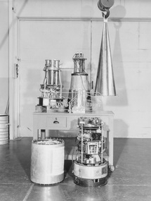
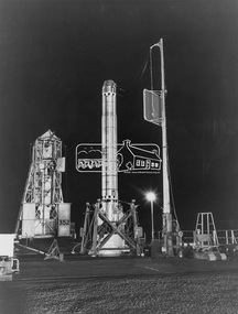
Photograph - Black and White Print, Weapons Research Establishment (WRE), British Black Knight Rocket on Launcher, 25 July, 1960
On reverse: British Black Knight Rocket on Launcher Also stamped in blue ink: Phone: Ex. 253 STILL PHOTO SECTION W.R.E. SALISBURY, S.A. Neg. No. E1548 (in pencil) Date: 25.7.60 (in pencil) Subject: B.K. (in pencil) Classification: RESTRICTED (over stamped) 9 Feb 1961 (over stamped)alan gardiner collection, 1960, 1960-07-25, black knight rocket, launch pad, rocket, salisbury, south australia, space industry, weapons research establishment (wre), woomera -
 Clunes Museum
Plan, CLUNES WATER SUPPLY
DRAWINGS MADE TO SET UP A PERMENT PIPED WATER SUPPLY TO NEW NORTH MINE, CLUNES, VICTORIA, AUSTRALIA1 PAGE PLAN WITH DRAWING OF CLUNES WATER SUPPLY ON WAXED PAPER USING RED, BLACK AND BLUE INKCLUNES WATER SUPPLY LONGITUDINAL SECTION OF CENTRE LINE OF THE LOWER AWUEDECT FROM WEIR A TO SERVICE RESERVOIR DRAWING 420 5 CONTRACT NO. 740 2 HORIZONTAL SCALE FOUR CHAINS TO AN INCH VERTICAL SCALE FORTY FEED TO AN INCH SIGNED BY OCTAVIUS LANGTREE WORKS ENGINEER 13/12/1870octavius langtree, peter lalor, clunes water supply -
 Mt Dandenong & District Historical Society Inc.
Photograph
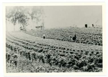
William Dower came with his family to the Mt Dandenong in 1898, taking up a 10 acre allotment. William and hs wife Elizabeth had seven boys (Will, Harry, Bert, Walter, Joe, Edgar, Robert) and four girls (Emmy, May, Ada, Ruby). The property secured by William Dower was known as ‘Cambridge Gardens’ and had a two room slab hut. William and his sons added another five rooms using trees from the property. The family established extensive crops and worked hard for their success. The acreage extended to 30 when the family bought up neighbouring properties.Black and white photograph showing rows of berry crops. Reverse of photograph has handwritten description by John Lundy-Clarke.LOT 10 section 2 of the Village Settlement owned as registered by Dobson, then Bert Dower, then Edgar Dower. Property was named "Bonnie View" and photo was taken from near where the Channel O tower stands looking south east towards corner of Ridge Road and Selwyn Lane taken 1920.bert dower, edgar dower, bonnie view, channel o, dobson, selwyn lane -
 Ballarat Tramway Museum
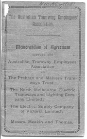
Book, Australian Tramway Employees Association (ATEA), "Memorandum of Agreement - ATEA with PMTT, NMETL, ESCo & Meakin & Thomas", 1913
Four separate agreements, one for each organisation. All details wages and conditions of work and disputes, grievances, and discipline, leave etc. Pages 1 - 10 - agreement with the PMTT - dated 14/1/1913, applied from 1/10/1912 to 1/6/1916. Signed for PMTT by Alex Cameron Chairman; Thomas King Member; and Thomas King Secretary and for Union by Lionel L. Hill President and A. C. Warton General Secretary. Pages 12 - 20 - ditto with NMELTL - dated 14/1/1913, applied from 1/1/1913 to 30/6/1916. Signed for NMETL by L. Voight, A.D. Murdoch and for Union by A. C. Warton General Secretary. Pages 21 - 32 - ditto with ESCo - dated 14/1/1913, applied from 1/12/1912 to 30/6/1916, includes rosters for Ballarat and Bendigo. Signed by William J Home for P. J. Pringle for ESCo and for Union by Lionel L. Hill President and A. C. Warton General Secretary. Pages 33 - 42 - ditto with Messrs Meakin and Thomas, Lessees of the Northcote Cable Tramways. Dated 14/1/1913, applied from 1/12/1912 to 30/6/1916. Signed by F.W. Meakin and Lena Thomas in front of Louis Waxman Solicitor and A. C. Warton, General Secretary. Yields information about the industrial agreements with Tramway operators in Victoria, except for MTOCo.Forty-Four page booklet, off-white paper, saddle-stapled, with additional dark grey colour paper cover titled "The Australian Tramway Employees' Association with the The Prahran & Malvern Tramways Trust / The North Melbourne Electric Tramways and Lighting Company Limited/ The Electric Supply Company of Victoria Limited and Messrs. Meakin and Thomas". Two copies held. "Ballarat Tramway Preservation Society Catalogue No. 213" in ink on top of first page, inside cover on both copies. Copy 1 - has name of "H.W.H.Collett" and "1913" on front cover, and pencil or red pencil notes against various rules in the ESCo section. Copy 2 - some minor pencil marks.trams, tramways, bendigo, ballarat, atea, unions, agreements, esco, nmetl, pmtt, northcote cable trams, meakin & thomas -
 Vision Australia
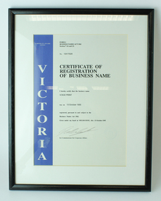
Certificate - Text, Certificate of Registration of Business Name - Voice Print, 13 October 1995
This certificate for the registration of the business name 'Voice Print' was registered with the Victorian Corporate Affairs in 1995.1 white page with single blue edge mounted on cardboardForm 2, Business Names (Act) 1962, Section 7(4) and (5) Corporate Affairs Office, Victoria I hereby certify that the business name ... was on ... registered pursuant to and subject to the Business Names Act 1962. Given under my hand at Melbourne, this 13 October 1995 ... for Commissioner for Corporate Affairsassociation for the blind, corporation records -
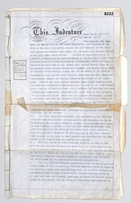 Bendigo Military Museum
Legal record - INDENTURE 1920, SOLDIERS MEMORIAL INSTITUTE, 22.4.1920
This document signed by the Mayor, Councilor's, Citizens and Bendigo Soldiers and Sailors Association on 22 4.1920 outlines the usage of the Soldiers Memorial Institute in Pall Mall Bendigo as a Rest Home for Returned Servicemen. Signed by, J.H. Curnow Mayor - A. Dunstan, W Beebe, Councilors - W Honeybone Town Clerk. Signed by Bendigo R.S.S.A by John Adams - Harold Robert Catford. Witnessed by George. F. Rolling, L. J. Beckerleg. Signed by, George Francis Cole, Alfred Morris Pool. Witnessed by G. Allen, W Beach. The Bendigo RSL/Bendigo District RSL Sub Branch still occupies the building which now is the home of the Bendigo Military Museum. Refer Cat No 800.2 for the opening of the Soldiers Memorial Institute in 1921. Refer Cat No 8048 for Harold Catford Bendigo R.S.S.A, Cat No 8022P for John Adams Bendigo R.S.S.ALegal record, blue paper, 5 pages of text all in black, one page with a sketch on half and the other is the front cover when folded by 3, pages held together by a green thin woven cord on the spine, pages have red lines as a border, there are 32 sub headings covering facets of the use of the building, there a few small notes added in the left hand column of some pages in blue pen.On the front folded cover underlined in some sections, "THE MAYOR COUNCILLORS AND CITIZENS OF THE CITY OF BENDIGO - with - THE TRUSTEES of the BENDIGO Branch of the Returned Sailors and Soldiers ASSOCIATION and the BENDIGO CITIZENS REST HOME COMMITTEE. (space) AGREEMENT AS TO THE REST HOME AND MEMORIAL INSTITUTE IN ROSILAND PARK At the bottom central, "Hyett and Hyett - Solicitors - Bendigo"brsl, smirsl, indenture 1920, legal -
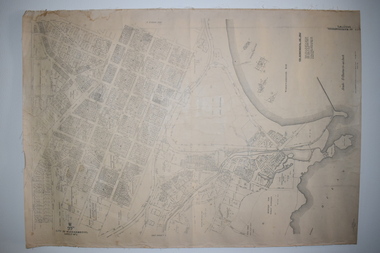 Warrnambool and District Historical Society Inc.
Documents Maps (3) - Warrnambool Town Allotments, City of W'bool Parish of Wangoom Country of Villiers, 1948
These maps were produced in 1948 and they contain maps of allotments within the city of Warrnambool, including the Central Business District, up to 1948. The details given on each allotment show the allotment and section numbers, the measurement in acres, the name of the original purchaser of the lot and the date of the first sale. The Warrnambool and District Historical Society owns several copies of these maps but these ones are originals.These three maps are of great significance because they give the names of land purchasers in Warrnambool from the date of the first land sales in 1847. They are a most valuable research tool and can be scanned and photocopied etc.These are three sheets of cream paper pasted on to linen. The sheets have black and white printing and map work. Some of the edges are a little frayed and there is some staining, particularly on the backs of the sheets.‘City of Warrnambool Parish of Wangoom County of Villiers Sheet 1’ ‘City of Warrnambool Parish of Wangoom County of Villiers Sheet 2’ ‘City of Warrnambool Parish of Wangoom County of Villiers Sheet 3’city of warrnambool, warrnambool maps, warrnambool town allotments 1948, land purchases -
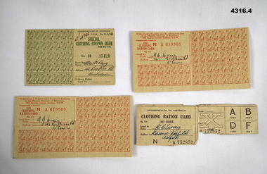 Bendigo Military Museum
Accessory - CLOTHING COUPONS, Commonwealth Govt of Australia, 1947, 1948
All the cards are various sizes with numbers of coupons/rations having been used. Items in a collection relating to Malcolm and Margaret Craig. Malcom James Craig initially enlisted in the CMF No N261604 then transferred to the 2nd AIF No NX170489 on 4.6.1942 age 18 years. Served in New Guinea. Discharged on 18.6.1946 with the rank of Driver in 52 Comp A/A Signals section..1) Clothing coupon green No 33425, 1948, issued by the Commonwealth Govt of Australia, hand written on. .2) Clothing ration red No A619909, 1948, issued by the Commonwealth Govt of Australia, hand written on. .3) Clothing ration red No A619908, 1948, issued by the Commonwealth Govt of Australia, hand written on. .4) Clothing ration light khaki No A752852, 1947, issued by the Commonwealth Govt of Australia, hand written on.Hand written on in pen. .1) "47/49792, Mrs M Craig 148 Banksia Rd Bankstown". .2) M.J. Craig 148 Banksia Rd B'town". .3) M.C. Craig 148 Banksia Rd B'town" .4) M.C.Turvey Masonic Hospital Ashfield".accessory, clothing, coupons, rations -
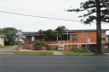 Phillip Island and District Historical Society Inc.
Photographs, Fuji Film, 2010
The original hospital was built in 1924 and the new building opened in 1962. It was closed after not being able to receive funding from State and Federal Governments. It's doors closed on January 31st 2008. A section of the hospital was run as a Nursing Home which opened in 1980. That too is closed. The "old" Cowes Medical Centre building is used for auxiliary medical services.Four coloured photographs of the Warley Hospital, Nursing Home and "old" Cowes Medical Centre, with a For Sale board showing "sold". warley hospital, carrol ryan -
 Halls Gap & Grampians Historical Society
Photograph - Coloured, C 1995
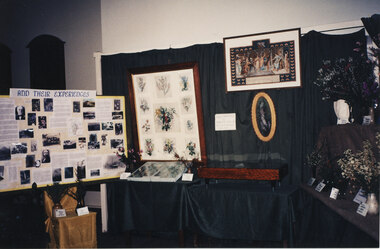
A display in the Historic Section of the 1995 Wildflower Show held in the Halls Gap Hall in 1995. The framed wildflower paintings are by Henrietta D'Alton. Beneath the frame in its current (2010) location in the Halls Gap Hall is a plaque which reads "Henrietta D'Alton (1836-1922). This collection of wildflower water-colours won an award at the Colonial & Indian Exhibition of 1886 in London".The photo shows a display of an historical theme set up in front of a dark fabric draped from a frame and over tables. A framed painting (consisting of twelve individual paintings) can be seen in the centre together with a certificate to its right.events, wildflower show -
 Warrnambool and District Historical Society Inc.
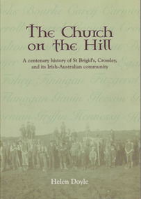
Book, Helen Doyle, The Church on the Hill :A centenary history of St. Brigid’s Crossley and its Irish Catholic community, 2014
History of St Brigid's Catholic Church and the Irish-Australian communityGreen tinted paperback with photograph of farming men with children and horses on front cover. Title and other text is dark brown edged in white. A number of Irish surnames are written in darker green on the paler part of front cover. This effect is also on back cover in tan lettering. The back cover description is written in brown text with image in oval above text.non-fictionHistory of St Brigid's Catholic Church and the Irish-Australian community warrnambool, crossley, st brigid's church, crossley catholic church, helen doyle -
 Orbost & District Historical Society
black and white photograph, 1934
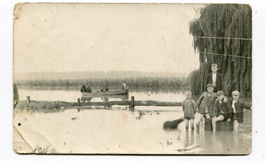
This photograph was taken during the flood of 1934 in Orbost. The people in the photograph are related to Billie and Ilma Nixon and Charlie Johnston. Damage estimated at £500,000 was caused by the 1934 floods in the Orbost district. This 1934 flood was devastating, destroying a section of the 1922 Orbost bridge, wrecking fences, bridges and roads, dumping silt and debris on the rich river flats and drowning cattle.This item is a pictorial record of a significant event in Orbost's history. It is associated with local families.A black / white photograph / postcard of floodwaters. On the right is a young man with four young boys sitting on a log. In the bckground is a rowing boat with one man rowing and three others sitting on the edges . A field of maize / corn is in the background and a large willow tree on the right.on back - "M. C. Rice Orbost 19 /1/20 M Gilbert. Mostly Billy Nixons & Charlie Johnstons 1934" [Note alteration: W C Rice rather than M C Rice].floods-orbost-1934 nixon-william johnston-charles -
 Federation University Historical Collection
Booklet, Ballarat Junior Technical School Mothers' Club, Recipe Book
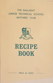
The Ballarat Junior Technical School was a division of the Ballarat School of Mines. The Recipe Book was produced by the Mothers' Club. Recipes were divided into sections: Soups, Savouries, Meat dishes, Desserts, Tea Cakes and Loaves, Biscuits and Slices, Cakes, Jams, Pickles and Sauces, Miscellaneous. There were Catering Hints and Handy Tips included. Booklet cost 40 cents.Yellow soft covered recipe book. The name of the person who provided each recipe is printed beside the recipe.ballarat junior technical school, recipes, ballarat junior technical school mothers' club, cooking, kitchen, hospitality -
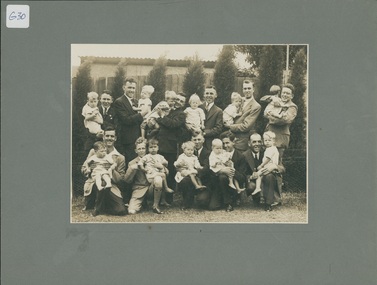 Uniting Church Archives - Synod of Victoria
Photograph, c.1930
Group of 11 young men photographed holding babies from the Methodist Babies' Home. The photograph was probably taken to mark the first birthday of the Babies' Home in 1930. The money for the property at 12 Copelen Street, South Yarra, was largely raised by the Young Men's section of the Methodist Church's Laymen's Missionary Movement. The donor's husband is one of the young men in the photgraph.B & W photograph mounted on cardmethodist babies' home, laymen's missionary movement, copelen street