Showing 16699 items
matching water-glass
-
 Bendigo Military Museum
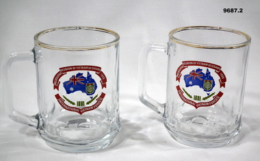
Memorabilia - COMMEMORATIVE GLASSES, 1988
Part of the Cooper Collection. See catalogue No. 9586.2 for details of service for 'Keith Cooper'.1. & 2. Drinking Glass with handle. Gold coloured paint applied to rim. Commemorative logo on side of glass. Logo features map of Australia with flag superimposed. red banner top and bottom with white lettering.1. & 2. Printed in white on red banners: 'REUNION OF VIETNAM VETERANS MELBOURNE, 1988, INTERNATIONAL VIETNAM FORCES!'cooper collection, keith cooper, memorabilia, vietnam war -
 Wodonga & District Historical Society Inc
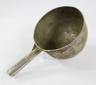
Functional object - Sand Scoop, North East Region Water Authority, Wodonga
The large aluminium sand scoop was used by Wodonga Waterworks Trust and it is part of the North East Region Water Authority collection in the Wodonga Historical Society. Wodonga's drinking water and wastewater were originally managed by the Wodonga Waterworks Trust, which was established in 1897, after Wodonga became a separate shire in 1876. In 1923 a Wodonga Waterworks Trust referendum to provide funding for new infrastructure to supply more water of better quality to Wodonga was passed. This included building the Wodonga Water Tower and it was completed in 1924. It supplied water to Wodonga until 1959, when it was drained and decommissioned after the No 1 Basin on Huon Hill was completed in 1958. In 1983 the Wodonga Waterworks Trust and the Wodonga Sewerage Authority became part of the Wodonga Council, and by 1989 a filtration plant at Huon Hill was completed, which provided filtered water of improved quality to Wodonga, in accordance with the World Health Organisation’s guidelines. In 1994 the Kiewa Murray Region Water Authority took over the Wodonga Council’s water and wastewater operations, and then in 1999 the Kiewa Murray Region Water Authority combined with the Ovens Region Water Authority and became the North East Region Water Authority or NERWA. NERWA then became known as North East Water. The sand scoop has local significance as part of the North East Region Water Authority collection donated to the Wodonga Historical Society. It also has wider state significance as a rare example of the equipment used in water management in Wodonga.Large aluminium scoop with a handle soldered on one side edge. Two holes and one indent in the end of the handle.north east region water authority, nerwa, wodonga waterworks trust, north east water, n.e. water, kiewa murray region water authority, sand scoop, metal scoop -
 Wodonga & District Historical Society Inc
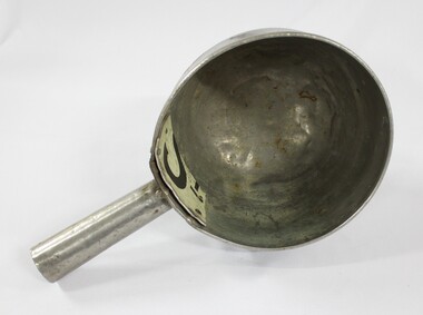
Functional object - Sand Scoop, North East Region Water Authority, Wodonga
The large aluminium sand scoop was used by Wodonga Waterworks Trust and it is part of the North East Region Water Authority collection in the Wodonga Historical Society. Wodonga's drinking water and wastewater operations were originally managed by the Wodonga Waterworks Trust, which was established in 1897, after Wodonga became a separate shire in 1876. In 1923 a Wodonga Waterworks Trust referendum to provide funding for new infrastructure to supply more water of better quality to Wodonga was passed. This included building the Wodonga Water Tower and it was completed in 1924. It supplied water to Wodonga until 1959, when it was drained and decommissioned after the No 1 Basin on Huon Hill was completed in 1958. In 1983 the Wodonga Waterworks Trust and the Wodonga Sewerage Authority became part of the Wodonga Council. And by 1989 a filtration plant at Huon Hill was completed, which provided filtered water of improved quality to Wodonga, in accordance with the World Health Organisation’s guidelines. In 1994 the Kiewa Murray Region Water Authority took over the Wodonga Council’s water and wastewater operations, and then in 1999 the Kiewa Murray Region Water Authority combined with the Ovens Region Water Authority and became the North East Region Water Authority or NERWA. NERWA then became known as North East Water. The sand scoop has local significance as part of the North East Region Water Authority collection donated to the Wodonga Historical Society. It also has wider state significance as a rare example of the equipment used in water management in Wodonga.Large aluminium scoop with a handle soldered on one side edge and a repair riveted to the interior surface of the scoop where the handle is located. The repair is a piece of sheet metal, with what looks like the lower part of the letter 'S' on it.Lower part of the letter "S" on the repair riveted to the interior surface of the scoop.north east region water authority, nerwa, wodonga waterworks trust, north east water, n.e. water, kiewa murray region water authority, metal scoop, sand scoop -
 Phillip Island and District Historical Society Inc.
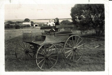
Photograph, Mrs Jansson, John on the McHaffie buggy
McHaffie family were early settlers on Phillip Island. Mrs Frank Jansson, wife of a fisherman from Rhyll.HistoricalSmall black & white photograph of a rural outlook with house and water in the background. Foreground has a wooden buggy on a grassy area with a woman and small child.The McHaffie buggy. Mrs F. Jansson and son, John.mchaffie family, mrs frank jansson, buggy -
 Phillip Island and District Historical Society Inc.
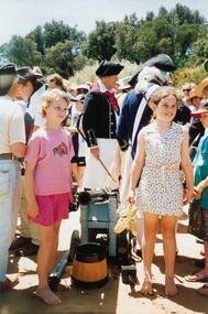
Photographs, Fuji Film, Re-enactment of the Landing of George Bass, 01/1998
A Plaque was erected on the occassion of the re-enactment. The wording is as follows: "In Recognition of a brave adventure on January 5 1998. Five men: Bern Cuthbertson (skipper), Tom O'Byrne (first mate), Craig Dixon, Rick McMahon and Geoff Zwan, landed in Flinders after 4 weeks at sea having rowed and sailed from Darling Harbour Sydney in the 'Elizabeth', a nine metre whale boat. This voyage re-enacted the discovery and naming of Western Port by Royal Navy Surgeon George Bass and his crew of five in 1798." They rowed an 8.7m long open whale boat some 1930 km from Port Jackson (Sydney).A collection of colour photographs taken at the re-enactment of the landing of George Bass. Showing "Sailors", a Canon, inside the boat, boats on the water and spectators on the foreshore.bass landing re-enactment 1998, george bass, san remo, p & e king -
 Phillip Island and District Historical Society Inc.
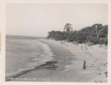
Photograph, 1940's - 1950's
One of a collection of 9 photographs donated by the former Shire of Phillip Island. One of a series of photographs sold as a pack of 7 postcards for tourists/visitors to Phillip island.Black & White photograph of view to the east along Eastern Beach Cowes showing several peple on beach and in the water. Trees on foreshore behind beach."Eastern Beach, Cowes, Phillip Island"eastern beach cowes phillip island, phillip island beaches, cowes beach phillip island, shire of phillip island -
 Phillip Island and District Historical Society Inc.
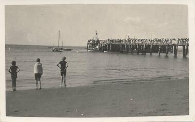
Photograph, 1940's or 1950's
One of 23 photographs from the Jessie Smith Collection - Donated by Stan McFeeBlack & White photograph of a crowd of people on the Cowes Jetty watching the yachts sailing off. Three people watching from the beach at the water's edge.On back: "Yacht Races etc at Cowes"cowes beach, phillip island, yacht racing, jessie smith collection, stan mcfee -
 Phillip Island and District Historical Society Inc.
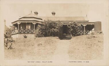
Photograph - Post Card, 1920's
Donated by Jean BainSepia Postcaard. Pathway with steps between trees leading to front door of Bayview Guest House. Water tank at right hand corner of house."Bayview" Cowes. Phillip Island. Valentines Series M 4848bayview guest house cowes, guesthouses cowes phillip island, phillip island, jean bain -
 Phillip Island and District Historical Society Inc.
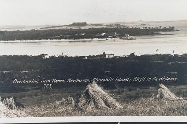
Photograph, Early 20th Century
One of 20 photographs/postcards donated by Mary KarneyBlack & White copy of postcard. View taken from San Remo overlooking township across the water to Newhaven, with Churchill Island and Rhyll in the background."Overlooking San Remo, Newhaven, Churchill Island; Rhyll in the distance. 285"san remo, newhaven phillip island, churchill island, rhyll phillip island, mary karney -
 Mortlake and District Historical Society
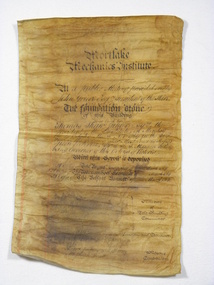
Document, Mortlake Mechanics' Institute Scroll
In April 1869 when the foundation stone of the Mortlake Mechanics' Institute was laid by Thomas Shaw of Wooriwyrite, this parchment scroll was sealed with other documents in the foundation stone. In 1891 when further alterations were made the hall these documents were retrieved from the stone. This building was erected to house the local library whichup until that time had been housed in the Morllake Common School.Discoloured foolscap parchment with copperplate lettering, some water damage which has caused the obliteration of the names of the Members of the Building Committee, Hon.Secretary and Architect. At a Public Meeting presided over by John Grieve Esq. President of the Shire/The foundation stone/of this building/was laid by - /Thomas Shaw Junior Esquire the President of the Institute on Monday/the 29th day of March A. D. 1869 in the 32nd year of the Reign of Her/Most Gracious Majesty Queen Victoria Sir I. A. T. Manners Sutton/being Governor of this Colony of Victoria/With this Scroll is Deposited/A copy of The Argus Newspaper of 28th March 1869/A copy of The Warrnambool Examiner of ? March 1869/A copy of The Belfast Examiner of 17th March 1869/Members of/The Building/ Committee/Hon.Secretary and Treasurer/Architect/Contractors/Messrs Jenkins and Harvey,Mason/Mr Joseph Wyatt,Carpenter.institute, free, libraries, public buildings, mortlake, mechanics -
 Glenelg Shire Council Cultural Collection
Slide - Slide - Cashmore Airport, Portland, 1980s
Coloured slide. Three people standing to left of drain full of water. Concrete slab across drain. Roller on right. Cashmore airport construction.portland airport, cashmore, engineering, construction, portland development -
Glenelg Shire Council Cultural Collection
Administrative record - Specifications - Laying water service to Library Cottage, c. 1931
Specifications for laying on water service to library cottage. Hand written in pencil on lined paper. Second page has rough drawing of layout of pipes.Back: Names of six tenderers, handwritten in pencil -
Glenelg Shire Council Cultural Collection
Negative - Negative - Nun's Beach, Portland, c. 1934
Negative for black and white photograph. Nun's Beach. Walkway to baths in foreground, camels sitting on beach. Whaler's Bluff with lighthouse and water tower in backgroundnegative, zillah maschmedt, nuns beach, portland, camels -
Glenelg Shire Council Cultural Collection
Programme - Programme - North Portland Water Tower lookout Official Opening 27 April 1996, 27/04/1996
Program, 4 pages, cream card, black print. North Portland water tower lookout official opening, Sat. 27th April, 1996 -
Halls Gap & Grampians Historical Society
Photograph - Sepia, C 1920s (?)
Men on the upstream embankment of Lake Wartook.Photo shows five men (one only partly visible n the left side) on the rocky embankment of a large body of water (Lake Wartook).scenery, lake wartook -
 Halls Gap & Grampians Historical Society
Photograph - B/W
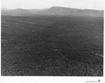
Photo is of Victoria Valley with Moora Moora Reservoir and the Victoria Range in the background. Photo would have been taken from around Reed's lookout area. Photo typical of promotional photos of the time by Forests CommissionLarge, densely treed valley with a body of water in background. Some roads can be seen particularly right foreground. There is a mountain range in the background. c1960sscenery, grampians ranges -
4th/19th Prince of Wales's Light Horse Regiment Unit History Room
Booklet, Field Engineering & Mine Warfare Pam 8 Part 1 (All Arms) Assault River Crossing 1948, 1948
A soft covered booklet written for use of unit commanders to train junior officers and NCO's in the duties they have to carry out in the crossing of water obstacles.WO Code No 8306assault river crossing -
4th/19th Prince of Wales's Light Horse Regiment Unit History Room
Booklet, Field Engineering & Mine Warfare Pam 8 Assault River Crossing Part 1 - All Arms 1961, 1961
A soft covered booklet for the practical instruction of junior officers and NCO's in elementary watermanship, the use of assault equipment and improvised methods of crossing water obstaclesWO Code No 9734. Supersedes WO Code 8306 (1948)military engineering, water crossing -
 Warrnambool and District Historical Society Inc.
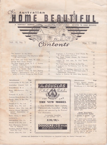
Magazine - Magazine monthly journal, The Australian Home Beautiful, 1/5/1940
4 page article & photos on Warrnambool home called 'Shipley' situated on the Hopkins. Dawson family1920's Century architecture Keith Cheetham. Owners Mr & Mrs A. G. Dawson50 page monthly journal. Showing housing, house hold tips. Black print on cream paper. Reasonable condition slightly water damagedVol 18 No 5. May 1 1940. journal. magazine. home beautiful. australia. household. recipes, shipley, hopkins river, home beautiful, dawson -
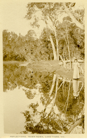 Federation University Historical Collection
Postcard, Howard D. Bulmer, Reflections, Nowa Nowa, Lake Tyers, Victoria
Nowa Nowa is located in Victoria on the Princes Highway between Lakes Entrance & Orbost. Tall eucalypts stand guard as you drive into this small village.The fresh waters of Boggy Creek and the tidal waters of Lake Tyers meet here. In the past its history was of logging. Black and white post card showing a lady in long skirt standing on the banks of a river with Australian eucalypts (gum tress) in the background and reflected in the water. nowa nowa, lake tyers, trees, river -
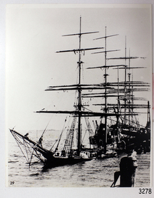 Flagstaff Hill Maritime Museum and Village
Photograph
Black And White Photograph of the Laira, Very Low In water at wharf . 202 mm X 253 mm Sh 162 Ships I - Lflagstaff hill, warrnambool, shipwrecked-coast, flagstaff-hill, flagstaff-hill-maritime-museum, maritime-museum, shipwreck-coast, flagstaff-hill-maritime-village, photograph, laira -
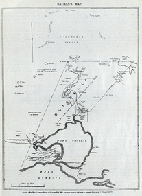 Federation University Historical Collection
Image, Batman's Map of Port Phillip
Scanned from "The Old Pioneers' Memorial History of Melbourne From the Discovery of Port Phillip to the World War". It is a facsimile map from the House of Commons Reports of Committee.John Batman's map of Port Phillip showing Dutigalla (Batman's Tract), a township reserve, open plains, public common reserve, fresh water"A tract of country [called?] by the native chief of Southern Ausralia to be John Batman 6th June 1935."port phillip bay, john batman, melbourne, iramoo, r. sarsh, river sarsh, river batman, yarra river -
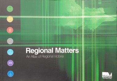 Federation University Historical Collection
Book, Department of Infrastructure, Regional Matters: An Atlas of Regional Victoria, C2003
Green soft covered book including chapers on population, jobs and industry, housing, road and rail transport, health services, education, and water resourcesvictoria, regional victoria, population, migration flow, jobs, industry, export, food production, housing, rail, roads, health, education, qualifications, water, irrigation -
 Glenelg Shire Council Cultural Collection
Photograph - Photograph - Lady Bay Reclamation: Dumping of surplus overburden in Lady Bay, January 1960, 1960
Port of Portland Authority archivesFront: (no inscriptions) Back: Lady Bay Reclamation (Pivot site)/ 1960 (pencil, upper left)port of portland archives, lady bay, reclamation, 1960s -
 Glenelg Shire Council Cultural Collection
Photograph - Photograph - Lady Bay Reclamation: Dumping of surplus overburden in Lady Bay, January 1960, 1960
Port of Portland Authority archivesFront: (no inscriptions) Back: (no inscriptions)port of portland archives, lady bay, reclamation, 1960s -
 Glenelg Shire Council Cultural Collection
Photograph - Photograph - Lady Bay Reclamation: Dumping of surplus overburden in Lady Bay, January 1960, 1960
Port of Portland Authority archivesFront: (no inscriptions) Back: Lady Bay Reclamation (Pivot site)/ 1960 (pencil, upper left)port of portland archives, lady bay, reclamation, 1960s -
Glenelg Shire Council Cultural Collection
Photograph - Photograph - Main Breakwater Construction, n.d
Port of Portland Authority ArchivesBack: Main Breakwater - pencilport of portland archives, portland harbour, breakwater -
 Glenelg Shire Council Cultural Collection
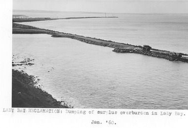
Photograph - Photograph - Lady Bay reclamation, 1960
Port of Portland Authority archivesFront: Lady Bay Reclamation: Dumping of surplus overburden in Lady Bay/ Jan. 1960 (typed below image, centre) Back: (no inscriptions)port of portland archives, lady bay, reclamation -
 Glenelg Shire Council Cultural Collection
Photograph - Photograph - Lady Bay Reclamation: Dumping of surplus overburden in Lady Bay, January 1960, 1960
Port of Portland Authority archivesFront: (no inscriptions) Back: Lady Bay Reclamation (Pivot site)/ 1960 (pencil, upper left)port of portland archives, lady bay, reclamation, 1960s