Showing 174032 items matching "1200-mair-street"
-
 Eltham District Historical Society Inc
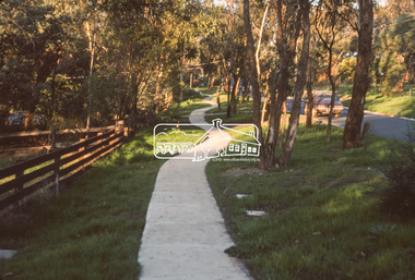
Slide, Quinn Estate, Sackville Street, Montmorency, May 1983
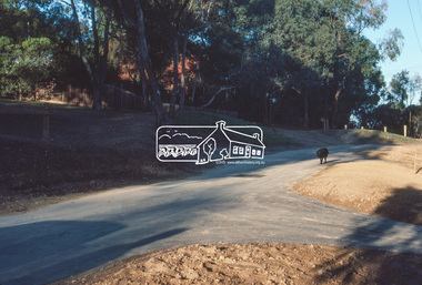
One of a series of images of roads and infrastructure taken by Eltham Shire Council Planning and Engineering officers, May 1983 specifically looking at Private Street Schemes post road construction/sealing operations35 mm colour positive transparency (1 of 21) Mount - Kodak Kodachrome Cardroads, infrastructure, road sealing, footpaths and gutters, private street scheme, housing estate, montmorency, quinn estate, sackville reserve, sackville street -
 Eltham District Historical Society Inc
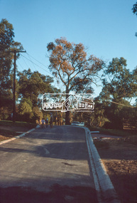
Slide, Frank Street, Eltham, May 1983
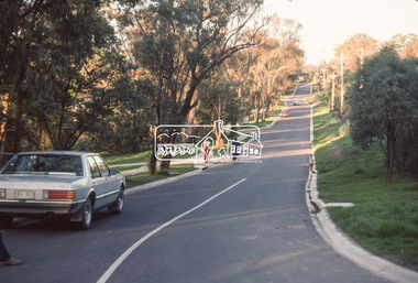
One of a series of images of roads and infrastructure taken by Eltham Shire Council Planning and Engineering officers, May 1983 specifically looking at Private Street Schemes post road construction/sealing operations35 mm colour positive transparency (1 of 21) Mount - Kodak Kodachrome Cardroads, infrastructure, road sealing, footpaths and gutters, private street scheme, eltham, frank street -
 Eltham District Historical Society Inc
Slide, Beard Street, Eltham, May 1983
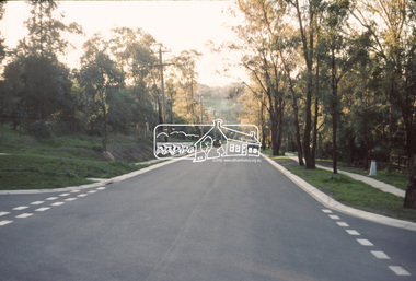
One of a series of images of roads and infrastructure taken by Eltham Shire Council Planning and Engineering officers, May 1983 specifically looking at Private Street Schemes post road construction/sealing operations35 mm colour positive transparency (1 of 21) Mount - Kodak Kodachrome Cardroads, infrastructure, road sealing, footpaths and gutters, private street scheme, eltham, beard street, frank street, shallard avenue -
 Eltham District Historical Society Inc
Slide, Thomas Street, Eltham, May 1983
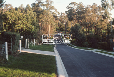
One of a series of images of roads and infrastructure taken by Eltham Shire Council Planning and Engineering officers, May 1983 specifically looking at Private Street Schemes post road construction/sealing operations35 mm colour positive transparency (1 of 21) Mount - Kodak Kodachrome Cardroads, infrastructure, road sealing, footpaths and gutters, private street scheme, eltham, thomas street -
 Eltham District Historical Society Inc
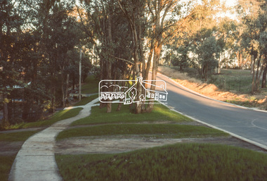
Slide, Andrews Street, Eltham, May 1983
One of a series of images of roads and infrastructure taken by Eltham Shire Council Planning and Engineering officers, May 1983 specifically looking at Private Street Schemes post road construction/sealing operations35 mm colour positive transparency (1 of 21) Mount - Kodak Kodachrome Cardroads, infrastructure, road sealing, footpaths and gutters, private street scheme, eltham, thomas street -
 Eltham District Historical Society Inc
Slide, Frank Street, Eltham, May 1983
One of a series of images of roads and infrastructure taken by Eltham Shire Council Planning and Engineering officers, May 1983 specifically looking at Private Street Schemes post road construction/sealing operations35 mm colour positive transparency (1 of 21) Mount - Kodak Kodachrome Cardroads, infrastructure, road sealing, footpaths and gutters, private street scheme, eltham, frank street -
 Eltham District Historical Society Inc
Slide, Andrews Street, Eltham, May 1983
One of a series of images of roads and infrastructure taken by Eltham Shire Council Planning and Engineering officers, May 1983 specifically looking at Private Street Schemes post road construction/sealing operations35 mm colour positive transparency (1 of 21) Mount - Kodak Kodachrome Cardroads, infrastructure, road sealing, footpaths and gutters, private street scheme, eltham, andrews street -
 Eltham District Historical Society Inc
Slide, Frank Street, Eltham, May 1983
One of a series of images of roads and infrastructure taken by Eltham Shire Council Planning and Engineering officers, May 1983 specifically looking at Private Street Schemes post road construction/sealing operations35 mm colour positive transparency (1 of 21) Mount - Kodak Kodachrome Cardroads, infrastructure, road sealing, footpaths and gutters, private street scheme, eltham, frank street -
 Eltham District Historical Society Inc
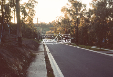
Slide, Beard Street, Eltham, May 1983
One of a series of images of roads and infrastructure taken by Eltham Shire Council Planning and Engineering officers, May 1983 specifically looking at Private Street Schemes post road construction/sealing operations35 mm colour positive transparency (1 of 21) Mount - Kodak Kodachrome Cardroads, infrastructure, road sealing, footpaths and gutters, private street scheme, eltham, beard street -
 Eltham District Historical Society Inc
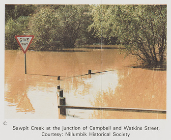
Work on paper (Sub-Item) - Photograph, Sawpit Creek at the junction of Campbell and Watkins Street, Diamond Creek Township, 8 April 1977
Colour photograph. Sawpit Creek at the junction of Campbell and Watkins Street, Diamond Creek Township. The Diamond Creek in flood at Diamond Creek township, 8 April 1977 Nillumbik Historical Society collectionflood, diamond creek, flooding, nillumbik historical society, give way, sawpit creek, campbell street, watkins street -
 Eltham District Historical Society Inc
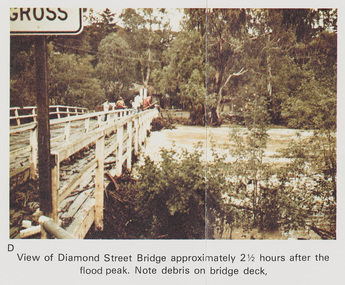
Work on paper (Sub-Item) - Photograph, Flooding, View of Diamond Street Bridge, Eltham 8 April 1977
Colour photograph. Flooding of Diamond Creek at Diamond Street Eltham bridge approximately 2 1/2 hours after the flood peak. Note debris on the bridge deck. 8 April 1977. flood, diamond creek, flooding, eltham, diamond street, bridge -
 Greensborough Historical Society
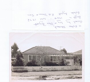
Photograph - Photograph (copy), 11 Ester Street Greensborough, 1972
11 Ester Street Greensborough was owned by Ivy and Des Bryant. Bought in 1964 and sold 1972. Estate agent R.H .Dean and Son. The land has since been subdivided and units built.Copy of black and white photographCaption written on copybryant family, ester street greensborough -
 Greensborough Historical Society
Advertising Leaflet, 1/184 Grimshaw Street Greensborough, 16/10/2017
1/184 Grimshaw Street Greensborough, 2 bedroom house sold 16/10/2017 for $626,000. Previous sales: July 2016 for $555,000, May 2010 for $350,000 and March 2003 for $218,000.Real Estate advertising leaflet,1 sheet folded into 4 pages, printed in colour both sides.grimshaw street greensborough -
 Greensborough Historical Society
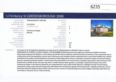
Advertising Leaflet, Barry Plant Greensborough, 1/74 Henry Street, 15/10/2018
Real estate advertising for 1/74 Henry Street Greensborough, 3 bedroom town houses; Unit 1 sold November 2018 for $786,000; and Unit 2 sold February 2017 for $831,000. Real estate advertisement black text and colour photographhenry street greensborough -
![Plan, Surveyor's Street Plan of Melbourne 1837 [copy], 1837_](/media/collectors/4f729f5697f83e03086015b8/items/534ccbc12162ef06c8d2cbf7/item-media/58afbfe2d0ce1616fcdf244b/item-fit-380x285.jpg) Greensborough Historical Society
Greensborough Historical SocietyPlan, Surveyor's Street Plan of Melbourne 1837 [copy], 1837_
Copy of Surveyor's Street Plan of Melbourne 1837. Donated by Patsy Coverdale and accompanied by brief details of her family connection to the map. Copies of plan available for sale from Greensborough Historical Society.Map of early Melbourne with connections to a current resident.Copy of plan, mounted on timber and framed.melbourne street plan, coverdaye, umpleby -
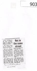 Greensborough Historical Society
Newspaper Clipping, Diamond Valley News, Not in the same street, 24/10/1978
William Street Greensborough was split into 'north' and 'south' when the rail crossing was closed. In this article one resident suggests that the north area have a change of name. This section is now called Pinehills Drive,Photocopy of news article, black and white text.william street greensborough, wuchatsch, pinehills drive -
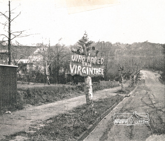 Eltham District Historical Society Inc
Photograph, Avenue of Honour trees on Main Road below Brougham Street. The sign is indicative of local anger at the pruning, 1969, 1969
Avenue of Honour trees on Main Road below Brougham Street, Eltham A sign on a severely pruned tree reads: "Who raped this virgin tree". The sign is indicative of local anger at the pruning, 1969Photocopy of photographeltham, avenue of honour, 1969, brougham street, main road, protests, roads, streets, vandalism, graffiti -
 Creswick Campus Historical Collection - University of Melbourne
Print - Framed print - 'Hospital and Spring Hill from Church Street, Creswick' by T.G. Moyle, 1881, Hospital and Spring Hill from Church Street, Creswick, 1881
Framed print - 'Hospital and Spring Hill from Church Street, Creswick' by T.G. Moyle, 1881. Limited edition print number 84 of 200. Published by Trustees of Creswick Historical Museum 1981.Print -
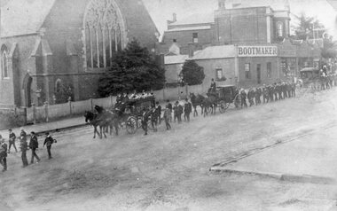 Stawell Historical Society Inc
Photograph, Mr Stanley Morris Barwise's Funeral Procession in Main Street Stawell in front of the Anglican Church with horse drawn carriages used by Mr Frank Crouch 1911
Funeral of Stanley Morris Barwise 1911. Main Street Stawell in front of the Anglican Church with Horse-drawn carriages (F. Crouch). Bootmaker and W Thomas Grocers visible near town hall. stawell -
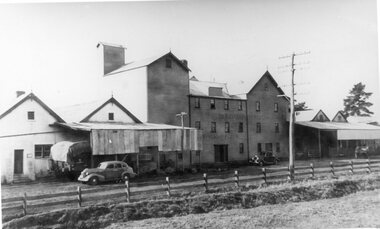 Stawell Historical Society Inc
Photograph, Wimmera Flour Mill in Taylor Street -- 2 Photos
Weatherboard three story Wimmera Flour Mill, Taylor Street Stawell. Founded 1876. Demolished 1988 after 112 years. One photo is looking East/South the other is North/ West.B/W photograph of Stawell Flour Mill, 2 motor cars, 1 wooden wagon, 1 loaded railway carriage covered with tarp. Three photos, one is an enlarged photograph of the smaller photo.The Wimmera Flour Mill Comp Sunlight Flourstawell industry -
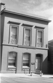 Stawell Historical Society Inc
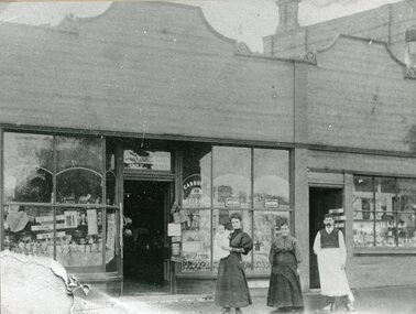
Photograph, O’Driscoll’s at 171 Main Street Stawell -- Former Oriental Bank & Australasia Bank. c 1884
This photograph is of a former Oriental Bank & previously Bank of Australasia, built by Terry & Oaken c 1884. Its address is 171 Main Street Stawell and now occupied by O’Driscoll W. D. Solicitor. Black & white photograph of a two story building, brick and concrete rendered with parapet. Security bars on window on the ground floor. Top floor at the base of each window there are decorative wrought iron screens. On the path out the front is a concrete & timber seat. stawell business -
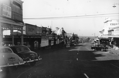 Stawell Historical Society Inc
Photograph, Main Street Stawell looking West from opposite Star Lane 1954
Main Street looking West from opposite Star Lane 1954. Bull and Mouth Hotel on left as is Dane Bros Grocers. Coles and Geo Mitchells on right. Holden's angle parked at left.stawell businesses streetscape -
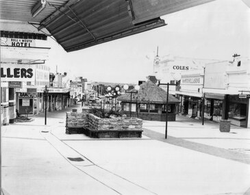 Stawell Historical Society Inc
Photograph, Main Street looking West from Fountain Area down Gold Reef Mall c1984
Main Street looking West from Fountain Area down Gold Reef Mall Shows Rotunda and planter boxes. Bull and Mouth Hotel at left of photo Geo Mitchell at right. C1984stawell businesses, streetscape -
 Stawell Historical Society Inc
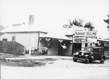
Photograph, Great Western Street Scene 1946
Great Western Street Scene 1946. Man standing outside the house on veranda. Adjoining shop with sign N.E. Houston Storekeeper and three petrol bowsers plus car parked out the front.Black & white photo showing a man standing outside a weather board house with an adjoining shop. A car is parked out the front of the building. N.E. Houston Store keeper Mobil oil Plume (written on the back) Bower's Shop Eric Houston August 14 - 1946stawell -
 Stawell Historical Society Inc
Photograph, Mr George Giles Hairdresser in Main Street Stawell on right 1908
Business George Giles Hairdresser Main Street Stawell 1908 on right. Shop next door on owned by brother Charlie Giles. Shops were between the Town Hall and Holy Trinity Church.Man two ladies and baby in front of shops with glass windows for displays stawell streetscape -
 Orbost & District Historical Society
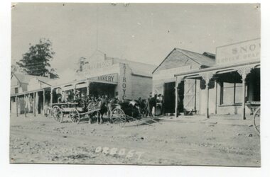
black and white photograph, August 1897
This photograph shows Nicholson Street, Orbost with horse teams in front Of Borland's Blacksmith shop and Royce's Bakery net door in August 1897.This is a pictorial record of the main street of Orbost in the late 19th century.A black / white photograph of the main street of Orbost. The road is unsealed. There are several wooden buildings facing the road and a cart with a team of horses is standing outside the blacksmith's building. A small child is standing behind the cart and several men are outside the bakery.on front - Orbostnicholson-street-orbost orbost-township borlands-blacksmith royces-bakery main-street-orbost -
 Wodonga & District Historical Society Inc
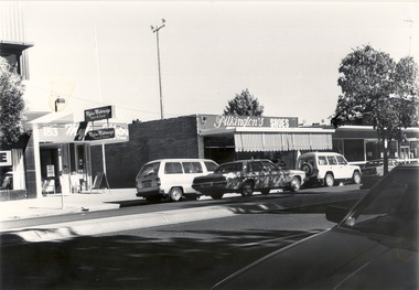
Photograph - Codling Collection 01 - Wodonga, High Street West - Mylons, Pilkington's, S.E.C, 1980s
Miss Olive Codling was a Foundation Member and a Life Member of the Wodonga Historical Society. Many of her prize-winning photos are held in the Society Collection. She also held a range of roles and committee positions in a wide range of Wodonga community organisations. These included the Horticultural Society, the Wodonga Arts Council, the Wodonga Camera Club and the Wodonga Lapidary Club. This photo collection is significant as it documents how the businesses and buildings in Wodonga have evolved and contributed to community throughout the 20th century.Wodonga, High Street West Businesses include Mylon Motorways and Pilkington shoes. 153 High Street, Wodonga in 2021is now the location of Gateway Health and other allied Health Services. In 1906 Patrick Mylon started a passenger transport service in the Albury-Wodonga border area with horses and cabs. His son Jack went into business in the late 1920s, and his grandson Bernie joined the firm early in 1970. When Patrick started with the horses and cabs, each cab carried eight passengers and he always had two horses per cab. As the business expanded, Mylons used a range of buses and coaches including Reo, Chev and Bedford vehicles. During more than 100 years if service to the Wodonga region and beyond, Mylon Motorways received many awards for Excellence and tourism. On July 2, 2008 the company, including its 31 buses and 45 staff members were transferred to the Dyson Group. On building facades on left "153 Mylon Motorways/Tours and Travel" On building on the right "Pilkington's SHOES"wodonga businesses, high st wodonga, pilkingtons shoes, mylon motorways -
 Melbourne Tram Museum
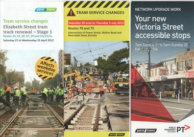
Pamphlet, Public Transport Victoria (PTV), "Tram service changes Elizabeth St tram track renewal stage 1", "Tram service changes - Routes 70 and 75 - Intersection of Power St, Wallen Road and Riversdale Road Burnley", "Your new Victoria Street accessible stops", 2012 and 2016
Set of three pamphlets advising of changes to tram services for the renewal of tram track works. All give the relevant service changes and maps. .1 - "Tram service changes Elizabeth St tram track renewal stage 1" - April 2012 - 2 fold DL .2 - "Tram service changes - Routes 70 and 75 - Intersection of Power St, Wallen Road and Riversdale Road Burnley" - June to July 2012 - 3 fold DL .3 - "Your new Victoria Street accessible stops" - Feb,. 2016 - 4 fold DL, including a Vietnamese translation. Details work between Hoddle and Church Streets. .4 - Route 70 - Swan St Burnley track renewal - 9 to 11 Jun 2012 - 3 fold DL 5 - Fitzroy St and The Esplanade - superstops.11/6 to 17/6/2011 - 3 fold DL Produced by Public Transport Victoria and Yarra Tramstrams, tramways, public transport, tram stops, elizabeth st, hawthorn, riversdale junction, wallen rd, route 70, route 75, route 109, victoria st, route 12, swan st, esplanade, route 70, fitzroy st -
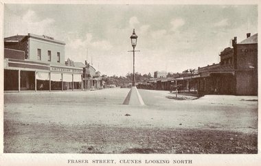 Clunes Museum
Photograph
.1 ORIGINAL BLACK AND WHITE PHOTOGRAPH POSTCARD OF FRASER STREET, CLUNES. LOOKING NORTH, GAS LIGHT IN CENTRE OF STREET. INCLUDES, CRITERION HOUSE, R THOMAS .2 .3 BLACK AND WHITE COPIES OF THE ABOVE PHOTOGRAPH ON GLOSS PHOTOGRAPHIC PAPER .4 BLACK AND WHITE COPY OF THE ABOVE PHOTOGRAPH ON MATTE PHOTOGRAPHIC PAPERFRASER STREET CLUNES. LOOKING NORTH local history, document, postcard, shops- r.thomas criterion house., clunes township -
 Eltham District Historical Society Inc
Postcard - Photograph postcard, Old Bridge, Kaylock's Crossing, Brougham Street, Eltham, c.1912
Date estimated to be circa 1912 based on the style of printing on the reverse of the card - Kodak Austral paper for real photo postcards, the paper was manufactured c.1908-1914 (See also POSTCARDS ON KODAK PAPER - IS IT POSSIBLE TO "DATE" THEM? http://tps.org.au/bb/viewtopic.php?t=115) Brougham Street was created in Josiah Holloway's 1851 subdivision of Little Eltham. It was one of several east-west streets shown on the subdivision plan as crossing the Diamond Creek. The western part was named Wellington Street on the subdivision plan but was later changed to conform with the name of the eastern part as acknowledgement of the continuity of the street. It is not known when the first bridge was constructed in Brougham Street however it was certainly mentioned at Council’s meeting of 2 June 1884 as being in a dangerous state of repair. This photo (c.1895) of an old bridge shows a very low-level simple log girder bridge crossing the creek at a right angle and so the approaches involved bends in the road alignment. This bridge was generally known as Kaylocks Bridge or Kaylock’s Crossing after the owner of the adjoining land. It was most likely built from around the mid-1850s, or a crossing of some fashion established as Richard George Kaylock, butcher of Little Eltham and his wife Emily Ann settled there in 1854. His property was in Wellington Street (now Brougham Street) and apparently extended across the Diamond Creek. The land on the western side of the creek was farmed, the house being on the eastern side. Kaylock's Bridge formed part of the original coach road to Eltham and in 1922 was described as an "old rustic bridge". Its low level and insubstantial construction made it susceptible to flood damage, necessitating frequent closures until repairs could be carried out. In September 1922, Council called for tenders for a new timber bridge to be constructed at Kaylock’s crossing. An engineering assessment carried out for the Council by Macleod Consulting at the time of the replacement suggested that the construction details indicate that it was in the 1900s, however this dating could possibly have been the result of numerous repairs undertaken over the years to flood damage. The tender was awarded to Mr Weller of Kangaroo Ground who commenced work in February 1923 on a higher-level timber trestle bridge. Work was slowed due to illness of the contractor and the accidental death of a man in March 1923 following the collapse of the bank after he had jumped into a hole that had just been blasted. The bridge was completed around July 1923 at which point the old structure was pulled up, marking what was described in the ‘Advertiser’ newspaper as the passing of an old and well-loved landmark in the district. In April 1924 the approach to Kaylocks bridge was washed away during the heavy flooding that destroyed the Main Road bridge. The western side was repaired, and an extra span was added to the eastern side using timber from the destroyed Main Road bridge. The bridge was again severely damaged four months later in August 1924 When a lack of finances delayed repairs to the Bridge Street bridge in 1931 (also referred to as Obelisk Bridge at the time), traffic had to detour via Brougham Street for some time. Local residents feared that the Bridge Street bridge might never reopen. Kaylocks Bridge was constantly subject to damage by floods. In the 1934 flood it was submerged by two feet of water. In more recent times the bridge was again severely damaged by flooding and repairs made. A new bridge and adjoining footbridge were constructed in 2009.Digital file only Postcards scanned from the collection of Michael Aitken on loan to EDHS, 2 Sep. 2022michael aitken collection, eltham, postcards, bridge, brougham street, diamond creek (creek), kaylocks bridge, wellington street