Showing 10846 items
matching maps
-
 Ballarat Tramway Museum
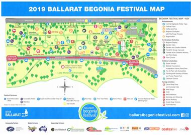
Map, City of Ballarat, "2019 Ballarat Begonia Festival Map", Mar. 2019
Map - printed in colour of off white paper titled "2019 Ballarat Begonia Festival Map" showing the various event locations in the Gardens area for the 2019 festival. Shows the tram stops and festival sponsors. On the rear is the program for each of the three days between 9/3/19 and 11/3/19.trams, tramways, begonia festival, map, events, btm -
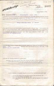
 Bendigo Military Museum
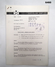
Administrative record - 1 Fd Svy Sqn Project Report - Operation Carto Mercury 1986, 28 Jan 1986
Operation Carto Mercury was a field completion Operation mounted by 1 Fd Svy Sqn 11 Aug 1985 to field complete 4 x 1:25000 compiled map sheet in the Cabarlah area to the North of Tawoomba. Included maps: 9243 - 23 Kingsthorpe, 9243 -24 Goombungee, 9243 - 21 Gomaren Creek, 9243 - 22 High FieldsA4 Typed document and diagrams, 14 pages. Report produced by 1 Fd Svy Sqn 1986royal australian survey corps, rasvy, fortuna, army survey regiment, army svy regt, asr, 1 fd svy sqn -
 Glen Eira Historical Society
Map - Caulfield Fire Station, No 26, Tree Reserve, Dandenong Road
A one page photocopy of an undated, unattributed, hand drawn map (200mm x 290mm) of the location on Tree Reserve, Dandenong Road, of the Caulfield Fire station, No 26. The map includes handwritten notes showing various nearby property owners. The file also includes a photocopy of a one page, undated and unattributed printout of the site address and site lease date.caulfield east, caulfield fire station, dandenong road, derby road, racecourse road, tree reserve, shire of caulfield, federal bank, st james building society, delves murchison, fire stations -
 Apollo Bay Museum
Audio - Bill Hurley Fraser Oral History Interview Apollo Bay May 2023
Local Otways residents (Gadubanud Country) were interviewed by artist/researcher Amy Tsilemanis for the 2023 storytelling project Heart Maps, a collaboration with the Apollo Bay Museum and Historical Society. Themes include memories of communication technologies, entertainments, school, work, community, and life near the ocean. More information here: https://amytsilemanis.com.au/portfolio/heart-mapsapollo bay, fishing, seafood -
 Apollo Bay Museum
Audio - Russell Frost Oral History Interview, Apollo Bay, April 2023
Local Otways residents (Gadubanud Country) were interviewed by artist/researcher Amy Tsilemanis for the 2023 storytelling project Heart Maps, a collaboration with the Apollo Bay Museum and Historical Society. Themes include memories of communication technologies, entertainments, school, work, community, and life near the ocean. More information here: https://amytsilemanis.com.au/portfolio/heart-mapsapollo bay, fishing, seafood -
 Apollo Bay Museum
Audio - Val Flitton Oral History Interview Apollo Bay April 2023
Local Otways residents (Gadubanud Country) were interviewed by artist/researcher Amy Tsilemanis for the 2023 storytelling project Heart Maps, a collaboration with the Apollo Bay Museum and Historical Society. Themes include memories of communication technologies, entertainments, school, work, community, and life near the ocean. More information here: https://amytsilemanis.com.au/portfolio/heart-mapsapollo bay, nursing, ww2 -
 Apollo Bay Museum
Audio - Nellie O'Meara Oral History Interview Apollo Bay April 2023
Local Otways residents (Gadubanud Country) were interviewed by artist/researcher Amy Tsilemanis for the 2023 storytelling project Heart Maps, a collaboration with the Apollo Bay Museum and Historical Society. Themes include memories of communication technologies, entertainments, school, work, community, and life near the ocean. More information here: https://amytsilemanis.com.au/portfolio/heart-mapsapollo bay, tourism -
 Apollo Bay Museum
Audio - Bob Telford Oral History Interview Apollo Bay May 2023
Local Otways residents (Gadubanud Country) were interviewed by artist/researcher Amy Tsilemanis for the 2023 storytelling project Heart Maps, a collaboration with the Apollo Bay Museum and Historical Society. Themes include memories of communication technologies, entertainments, school, work, community, and life near the ocean. More information here: https://amytsilemanis.com.au/portfolio/heart-mapsapollo bay, community, radio, youth club -
 Apollo Bay Museum
Audio - Irene Newton Oral History Interview Apollo Bay May 2023
Local Otways residents (Gadubanud Country) were interviewed by artist/researcher Amy Tsilemanis for the 2023 storytelling project Heart Maps, a collaboration with the Apollo Bay Museum and Historical Society. Themes include memories of communication technologies, entertainments, school, work, community, and life near the ocean. More information here: https://amytsilemanis.com.au/portfolio/heart-mapsapollo bay -
 Apollo Bay Museum
Audio - John Marriner Oral History, Apollo Bay April 2023
Local Otways residents (Gadubanud Country) were interviewed by artist/researcher Amy Tsilemanis for the 2023 storytelling project Heart Maps, a collaboration with the Apollo Bay Museum and Historical Society. Themes include memories of communication technologies, entertainments, school, work, community, and life near the ocean. More information here: https://amytsilemanis.com.au/portfolio/heart-mapsapollo bay, hordern vale -
 Apollo Bay Museum
Audio - Val Cameron Oral History, Apollo Bay April 2023
Local Otways residents (Gadubanud Country) were interviewed by artist/researcher Amy Tsilemanis for the 2023 storytelling project Heart Maps, a collaboration with the Apollo Bay Museum and Historical Society. Themes include memories of communication technologies, entertainments, school, work, community, and life near the ocean. More information here: https://amytsilemanis.com.au/portfolio/heart-mapsapollo bay, hospital, nursing -
 Apollo Bay Museum
Audio - Olive and Gordon Currie Oral History, Apollo Bay April 2023
Local Otways residents (Gadubanud Country) were interviewed by artist/researcher Amy Tsilemanis for the 2023 storytelling project Heart Maps, a collaboration with the Apollo Bay Museum and Historical Society. Themes include memories of communication technologies, entertainments, school, work, community, and life near the ocean. More information here: https://amytsilemanis.com.au/portfolio/heart-mapsapollo bay, farming, killala rd -
 Apollo Bay Museum
Audio - Neville Fisk Oral History, Apollo Bay April 2023
Local Otways residents (Gadubanud Country) were interviewed by artist/researcher Amy Tsilemanis for the 2023 storytelling project Heart Maps, a collaboration with the Apollo Bay Museum and Historical Society. Themes include memories of communication technologies, entertainments, school, work, community, and life near the ocean. More information here: https://amytsilemanis.com.au/portfolio/heart-mapsapollo bay, fishing -
 Apollo Bay Museum
Audio - Yvonne Francis Oral History Interview Apollo Bay May 2023
Local Otways residents (Gadubanud Country) were interviewed by artist/researcher Amy Tsilemanis for the 2023 storytelling project Heart Maps, a collaboration with the Apollo Bay Museum and Historical Society. Themes include memories of communication technologies, entertainments, school, work, community, and life near the ocean. More information here: https://amytsilemanis.com.au/portfolio/heart-mapsapollo bay, community radio -
 Apollo Bay Museum
Audio - Bruce Costin John Berry Sylvia Jones Oral History Interview Apollo Bay May 2023
Local Otways residents (Gadubanud Country) were interviewed by artist/researcher Amy Tsilemanis for the 2023 storytelling project Heart Maps, a collaboration with the Apollo Bay Museum and Historical Society. Themes include memories of communication technologies, entertainments, school, work, community, and life near the ocean. More information here: https://amytsilemanis.com.au/portfolio/heart-mapsapollo bay, pubs -
 Apollo Bay Museum
Audio - John Verey Oral History, Apollo Bay April 2023
Local Otways residents (Gadubanud Country) were interviewed by artist/researcher Amy Tsilemanis for the 2023 storytelling project Heart Maps, a collaboration with the Apollo Bay Museum and Historical Society. Themes include memories of communication technologies, entertainments, school, work, community, and life near the ocean. More information here: https://amytsilemanis.com.au/portfolio/heart-mapsapollo bay, golf course, surf lifesaving club -
 Vision Australia
Map - Object, Victorian railways map
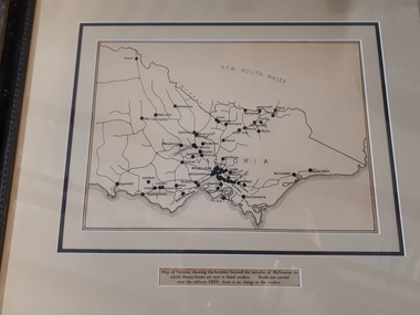
A black and white map of Victoria showing the railway lines where mail is transported and the individual towns listed next to the dot that provides location of such. Underneath is written "Map of Victoria showing the localities beyond the suburbs of Melbourne to which library books are sent to blind members. Books are carried over the railways FREE there is no charge to the readers." Through the work of Tilly Aston, braille postage was provided free by the Victorian Railways which greatly assisted the Braille Library in reaching members who resided outside of Melbourne. This map was produced to show the extent of the work by the Victorian Association of Braille Writers and the need for reading materials across the state.Paper of Victorian railway lines mounted in framevictorian association of braille writers, marketing -
 Bendigo Military Museum
Manual - TM5 - 245: (US) Department of the Army Technical Manual - Map Reproduction, US Department of the Army, United States of America, War Office, 10 Sep 1956
Nine Chapters describing all aspects of Map Reproduction. 224 pages, including 8 appendices, glossary and indexA soft covered military manual, 224 pages of text, diagrams and annotated photographs"AHQ Survey Regiment" stamped inside front and back covers. Number "149" handwritten inside front cover.royal australian survey corps, rasvy, fortuna, army survey regiment, army svy regt, asr, mapping -
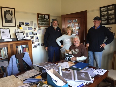
 Greensborough Historical Society
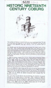
Leaflet, Coburg Historical Society, Historic nineteenth century Coburg, 1980s
A short history of 19th century Coburg, Victoria covering points of interest. Includes a map of the landmarks covered in the text. One page, printed on both sides in black and white text, drawings and photographs. Folded into 5. coburg (victoria), pentridge -
 Greensborough Historical Society
Newspaper Clipping, Making room for cash, 14/10/2015
The "Garage Sale Trail" took place on 24th October 2015 with the opportunity for buyers to map out the sales in their area.News clipping, black text, colour image.greensborough, garage sale trail -
Stawell Historical Society Inc
Photograph, Re-Accreditation Meeting 2012
Left Gray Withers, MAP reps, Wendy & Jim Melbourne, Robert Illig, Leslie Ellis * Dorothy Brumby2 Colour Photographs: Various people seated aroud a table.stawell historial society -
 National Wool Museum
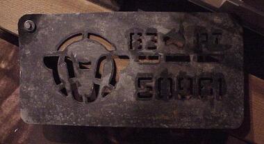
Stencil
Metal stencil, rectangular with rounded corners. Cut out of a sheep's head, map of Australia, and 83 PI 57187.83 PI 57187shearing wool bales, shearing, wool bales -
 Whitehorse Historical Society Inc.
Map - Atlas
Hand drawn maps of Europe, United States, North Pacific Ocean, Great Britain, China, Iberia Peninsular.Hand-made atlas in an exercise book. Book is covered by Brown paper.E. J. Harris VIII grade Princess Hill. -
 Apollo Bay Museum
Audio - School memories
Hear Val Flitton, Norma Begely Gordon Currie on school memories. Created as part of the Heart Maps projectapollo bay, school, oral history -
 Apollo Bay Museum
Audio - Irene Newton on guesthouses and holidaying
Hear museum volunteer Irene Newton speak on the local guesthouses and holiday activities. Created for the Heart Maps projectapollo bay, tourism, guesthouses -
 Apollo Bay Museum
Film - Norma Begely on Waratah Caravan park
Audio slideshow with Norma Begely on Waratah Caravan park. Created as part of the Heart Maps project with Amy Tsilemanisapollo bay, caravan park, 1950s -
 Apollo Bay Museum
Film - John Marriner on Hordern Vale
Audio slideshow with John Marriner discussing Hordern Vale. Created as part of the Heart Maps project with Amy Tsilemanisfarming, hordern vale, oral history -
 Kilmore Historical Society
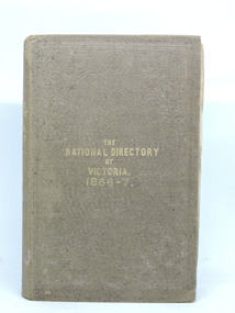
The National Directory of Victoria, The National Directory of Victoria. 1866-7, 1866
Butler & Brooke's National Directory of Victoria for 1866-7. Correct and complete map of the Colony, and The Victorian Yearly Advertiser.Brown cloth-bound hardcover book. Embossed border decoration front and back covers. Mildew spotting to front cover and page edges. Front cover partially separated from body. Binding loose. Pull-out page of advertisments before title page. 405 pp. plus advertisements front and back plus Squatting Directory and Towns' Directories. Fair condition.Inside front cover. 'Nesta McKellar'.victorian directory -
 Bendigo Historical Society Inc.
Document - MCCOLL, RANKIN AND STANISTREET COLLECTION: INDENTURE NORTH DEBORAH MINING COMPANY, 20th November, 1952
6 page document ' Gold Mining Lease Crown land Number 11307 Bendigo' plus map. Indenture document between Queen Elizabeth 11 and North Deborah Mining Company No Liability, Parish of Sandhurst, dated 20th November, 1952 re Vol 333, Folio 053. Land indicated by yellow on map and below ' a depth of one hundred and fifty feet from the surface of the land indicated by purple colour and delineated on the plan' Document signed by J. Stanistreet, Manager, North Deborah Mining Company No Liability. Map, fixed to document, heading ' Mining District of Bendigo, No. 11307, County of Bendigo, Parish of Sandhurst, Total area 13 acres 2 roods, 11 perches. Map shows large dam on Crown land, transmission line excised 150 ft., written on purple area. Underneath map ' provided that the dam indicated on the said plan is hereby reserved'.bendigo, mining, north deborah mining company -
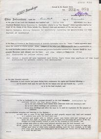
 Bendigo Historical Society Inc.
Document - MCCOLL, RANKIN AND STANISTREET COLLECTION: INDENTURE, GOLD MINING LEASE CROWN AND RONALD ALEXANDER RANKIN, BENDIGO, 24th June 1941
6 page document, Gold Mining Lease 11166, plus map. Indenture between Crown (King George VI) and Ronald Alexander Rankin of Bendigo, dated 24th June, 1941. Map No. 11166 Bendigo, Mining District of Bendigo, Parish of Sandhurst, County of Bendigo. Map shows lease 11166 marked in yellow with shaft, ore bins and tramway marked. Belle Vue Road , Adam Street and Griston Street shown on map. ( Golden Gully area) Dams indicated on lease holdings. Other lease holdings: 1675 T.L.9858, 10990, 11013, 11062, 11165, 11063 (void) 1172 W.R. (dam thereon) 9882 (void). Some residential lots marked along Belle Vue Road, and Adam Street. On bottom of map 21.8.41 in pencil. On last page of document : North Deborah Mining Company now the proprietor of the within described estate by transfer registered on 11th November 1914.bendigo, mining, north deborah lease, belle vue road, adams street, griston street, golden gully, ronald alexander rankin, north deborah mine.