Showing 7122 items matching "snowy-river"
-
 Bendigo Historical Society Inc.
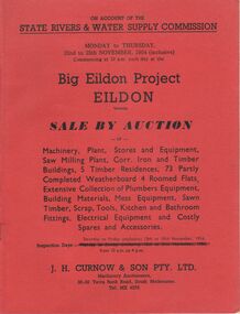
Document - IAN DYETT COLLECTION: AUCTION CATALOGUE - BIG EILDON PROJECT
Two red covered auction catalogues for an auction on account of the State Rivers & Water Supply Commission on the 22nd to 25th November, 1954 (inclusive) held at the Big Eildon Project, Eildon, Victoria. Lots sold include Machinery, plant, stores and equipment, Saw Milling Plant, corr. Iron and timber buildings, 5 timber residences, 73 partly completed weatherboard 4 roomed flats, extensive collection of plumbers equipment, building materials, mess equipment, sawn timber, scrap, tools, kitchen and bathroom fittings, electrical equipment and costly spares and accessories. Catalogue has a Locality Plan of Eildon, photo, locality and description of the Eildon Sawmill. Photos of completed houses, incomplete flats and plan showing layout of flat unit, photo of flat block (Completed). Also Building Kits - Designs and Component Lists.business, auctioneers, j h curnow & son pty ltd, ian dyett collection - auction catalogue - big eildon project, state rivers & water supply commission, j h curnow & son pty ltd, eildon sawmill, prahran telegraph printing co -
 Kew Historical Society Inc
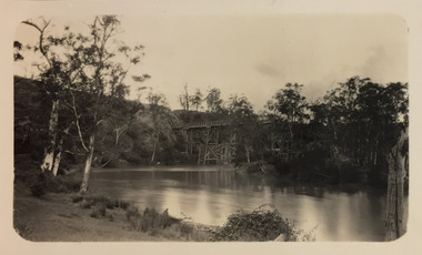
Photograph - Zig-Zag Bridge, 1924
Henry Beater Christian (1886-1962) , was a descendant of one of the earliest settler families in Kew. Employed at the Kew Asylum as a 'public servant', he was a skilled amateur photographer, photographing numerous scenes in Kew and on his travels around Victoria. The majority of his photographs date from 1916 to 1929. His finest photographs are housed in two photograph albums. Digital copy of a photograph from page 8 of the 47-page photograph album containing 261 gelatinous silver images, loaned by Diane Washfold with permission given to digitise and hold a copy in our collection. This photograph reveals how the photographer, Henry Christian, positioned himself to take the photograph from the angle in which he was interested. A skilled canoeist, an empty canoe is on the left bank that he apparently he used to access his vantage point. His subject, the Zig-Zag Bridge linked the grounds of the Yarra Bend and Kew Asylums. The wooden bridge was constructed in the 1870s and lasted through numerous floods until its destruction in 1929. A horizontal structure, the walkway was reached via a wooden staircase on the Studley Park end. The steps were requires due to the different levels of the banks on this stretch of the river. "Zig-Zag Bridge"henry beater christian (1886-1962), landscape photography, kew (vic.) — yarra river, christian-washfold collection, photograph albums, zig-zag bridge -
 Kew Historical Society Inc
Photograph - Zig-Zag Bridge, 1924
Henry Beater Christian (1886-1962) , was a descendant of one of the earliest settler families in Kew. Employed at the Kew Asylum as a 'public servant', he was a skilled amateur photographer, photographing numerous scenes in Kew and on his travels around Victoria. The majority of his photographs date from 1916 to 1929. His finest photographs are housed in two photograph albums. Digital copy of a photograph from page 8 of the 47-page photograph album containing 261 gelatinous silver images, loaned by Diane Washfold with permission given to digitise and hold a copy in our collection. This photograph reveals how the photographer, Henry Christian, positioned himself to take the photograph from the angle in which he was interested. A skilled canoeist, an empty canoe is on the left bank that he apparently he used to access his vantage point. His subject, the Zig-Zag Bridge linked the grounds of the Yarra Bend and Kew Asylums. The wooden bridge was constructed in the 1870s and lasted through numerous floods until its destruction in 1929. A horizontal structure, the walkway was reached via a wooden staircase on the Studley Park side. The steps were requires due to the different levels of the banks on this stretch of the river. "Zig-Zag Bridge"henry beater christian (1886-1962), landscape photography, kew (vic.) — yarra river, christian-washfold collection, photograph albums, zig-zag bridge -
 Kew Historical Society Inc
Photograph - Grampians, 1924
Henry Beater Christian (1886-1962) , was a descendant of one of the earliest settler families in Kew. Employed at the Kew Asylum as a 'public servant', he was a skilled amateur photographer, photographing numerous scenes in Kew and on his travels around Victoria. The majority of his photographs date from 1916 to 1929. His finest photographs are housed in two photograph albums. Digital copy of a photograph from page 12 of the 47-page photograph album containing 261 gelatinous silver images, loaned by Diane Washfold with permission given to digitise and hold a copy in our collection. The first and last pages in the album document the Yarra River at Studley Park and at Kew. The remainder of the album includes photographs of walking and car tours in rural Victoria including 'wilderness' areas in the Grampians, Gippsland and the High Country. Six album pages document a camping trip by Henry Christian to the Grampians in September 1924. The photos include pictures of lookouts, and natural features including rock faces and waterfalls, as well as his camp site. This photo is of a man, perhaps Henry Christian, holding his camera while standing on one of the lookouts on what is probably the Mt Victory trail. The photo was framed in a circle during the development process. "Mt Victory / Grampians / 9.24"henry beater christian (1886-1962), landscape photography, christian-washfold collection, photograph albums, grampians, mt victory, gariwerd -
 Kew Historical Society Inc
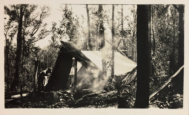
Photograph - Campsite in the Grampians, 1924
Henry Beater Christian (1886-1962) , was a descendant of one of the earliest settler families in Kew. Employed at the Kew Asylum as a 'public servant', he was a skilled amateur photographer, photographing numerous scenes in Kew and on his travels around Victoria. The majority of his photographs date from 1916 to 1929. His finest photographs are housed in two photograph albums. Digital copy of a photograph from page 12 of the 47-page photograph album containing 261 gelatinous silver images, loaned by Diane Washfold with permission given to digitise and hold a copy in our collection. The first and last pages in the album document the Yarra River at Studley Park and at Kew. The remainder of the album includes photographs of walking and car tours in rural Victoria including 'wilderness' areas in the Grampians, Gippsland and the High Country. Six album pages document a camping trip by Henry Christian to the Grampians in September 1924. The photos include pictures of lookouts, and natural features including rock faces and waterfalls, as well as his camp site. This photo is of one of his campsites. The tent, beside which a man is standing, is a simple canvas sheet held up by ropes and supported at one end by large slabs of bark. "Mt Victory / Grampians / 9.24"henry beater christian (1886-1962), landscape photography, christian-washfold collection, photograph albums, grampians, mt victory, gariwerd -
 Kew Historical Society Inc
Photograph - Grampians, 1924
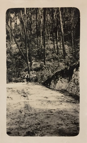
Henry Beater Christian (1886-1962) , was a descendant of one of the earliest settler families in Kew. Employed at the Kew Asylum as a 'public servant', he was a skilled amateur photographer, photographing numerous scenes in Kew and on his travels around Victoria. The majority of his photographs date from 1916 to 1929. His finest photographs are housed in two photograph albums. Digital copy of a photograph from page 15 of the 47-page photograph album containing 261 gelatinous silver images, loaned by Diane Washfold with permission given to digitise and hold a copy in our collection. The first and last pages in the album document the Yarra River at Studley Park and at Kew. The remainder of the album includes photographs of walking and car tours in rural Victoria including 'wilderness' areas in the Grampians, Gippsland and the High Country. Six album pages document a camping trip by Henry Christian to the Grampians in September 1924. The photos include pictures of lookouts, and natural features including rock faces and waterfalls, as well as his camp site. This is a photo of a man in the distance on a bush track who is looking over his shoulder at the camera. He carries a sack and has a swag on his back. This may be Henry Christian or a companion."Grampians"henry beater christian (1886-1962), landscape photography, christian-washfold collection, photograph albums, grampians, gariwerd -
 Kew Historical Society Inc
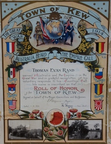
Certificate, Town of Kew, Thomas Evan Rand : Roll of Honor of the Town of Kew, 1918
Thomas Evan Rand was born at Hawthorn. He enlisted for service during World War One as an almost 20 year old engineering student, serving with the Australian Flying Corps.A commemorative certificate documenting the war service of Thomas Evan Rand of ‘Urangeline’, Barkers Road, Kew. Thomas Rand was an engineering student when he enrolled as a private in the Australian Army. He embarked on HMAT Orsova A67 on 16 March 1916. He was enlisted in the No 1 Squadron, Flying Corps. The formal certificate records that ‘ Thomas Evan Rand served Australia and the Empire in the Great War and in grateful recognition of his voluntary response to his Country’s Call his name is inscribed on the Roll of Honor of the Town of Kew’. The then Mayor and Town Clerk signed the certificate. [Kew did not become a ‘City’ until 1921]. The certificate highlights emblems and symbols of Australia and Great Britain, and includes the coats of arms of the allies in the war. The certificate is customised with two black and white photographs of Kew: the rotunda in the Alexandra Gardens at left, and boating on the Yarra River at right.Thomas Evan Rand served Australia and the Empire in the Great War and in grateful recognition of his voluntary response to his Country's Call his name is recorded on the Roll of Honor Town of Kew on behalf of the Mayor, Councillors and Burgesses. 1.8.18. E.P. Wynne [Mayor] H. Harrison [Town Clerk]roll of honor (kew), thomas evan rand, world war one, thomas rand, urangeline, kew, australian flying corps, alexandra gardens, wwi, yarra river -
 Melbourne Tram Museum
Pamphlet, Yarra Trams, "Your new accessible tram stops", Apr. 2007
Set of five Pamphlets - DL - 3 fold, full gloss paper titled "Your new accessible tram stops" about the introduction in April 2007 of upgrades stops in Burwood Highway - stops 59, 61, 62, and 63 to Superstops. Has VicRoads logos as well as Vic Government and Yarra Trams. Two copies held. 1 -2 fold DL - for stops 124A on routes 96, 109, and 112 - on the Specert St Bridge over the Yarra River - has map. 2 - 3 fold DL for stops 38, 42, 48 and 52 Dandenong Road - Nov. 2007 3 - 3 fold DL for stops 22, 23, 24 and 26 Queens Parade Fitzroy North, Nov. 2008 4 - 3 fold DL for stops 53 to 59 - Matthews Ave Airport West April 2008trams, tramways, yarra trams, burwood, vermont south, superstops, route 75, spencer st, route 96, route 109, route 112 -
 Bendigo Military Museum
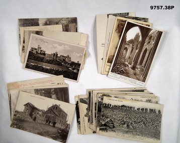
Postcard - PHOTOGRAPHIC POSTCARDS WW1, C.WW1
Items in the collection relating to C.J.C. McQuie MM, refer Cat No 9680P for his service details. Postcard No's .10) - 15). These are from a Series that have printed text in Red at the top of the images. Postcards .16) - 38). These are from a major Series, all have at the top "Campagne DE 1914 - 1916" and cover bomb damage in many areas across the "Somme" region..1) Postcard sepia tone of a Chalet in "Ostende". .2) Postcard sepia tone of a Church 1916 "Strazeele". .3) Postcard sepia tone, river scene in "Amiens". .4) - .5) One sepia, one B & W scenes in "Hazebrouck". .6) Postcard B & W, bomb damage "Albert". .7) Postcard B & W, bomb damage "Hazebrouck". .8) - .9) Postcard One B & W one sepia Bomb damage "Dunkerque" .10) - .11) Postcard B & W bomb damage around "Strazeele". .12) Postcard sepia tone, bomb damage "Strazeele". .13) Postcard B & W, bomb damage "Kemmel". .14) Postcard B & W, bomb damage "Merris". .15) Postcard B & W, bomb damage "Messines". .16) - .38) B & W series bomb damage various places. postcards, photos, mcquie -
 Bendigo Historical Society Inc.
Postcard - Australia, Elliot Collection, 1895 - 1914
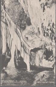
Thought to have originated in Austria in 1869, postcards first gained popularity in Australia in the 1890s.They were used to send short messages to friends and family. This collection was generated by Mary Emma Elliot of Talgarno. Talgarno is a rural locality in Victoria, Australia, situated on the southern shoreline of Lake Hume, about 23 km east of Albury-Wodonga. The collection contains postcards from across the world. Mary Emma Sibley was born in Ironbark, Bendigo in 1859. She married James Elliot in 1893 and they settled at “Kelso”, Talgarno. They had two children – Mona and Sibley. Mary Emma Elliot died in Melbourne in 1944, aged 84 years.Australian postcards collected by Mrs. James Elliot between 1898 and 1915. 1405.021 Crystal Palace R I Jenolan 1405.022 Snowball Cave, Lucas, Jenolan, N.S.W. 1405.023 The Great Zig-Zag 1405.024 Sydney Harbour and Botanical Gardens 1405.025 Barren Jack Works 1405.026 Mountain Homes, Illawarra 1405.027 The Weir, Yass 1405.028 Forest Creek Falls, Yass 1405.029 Yass Town 1405.030 Musgrove Point 1405.031 St. Clements Church of England, Yass 1405.032 Watson's Bay, Sydney 1405.033 Coal Mine Gully, Blackheath, N.S. W. 1405.034 Barren Jack, Murrumbidgee River, Yass 1045.035 The Heads, Sydney Harbour 1405.036 Hyde Park, Sydney 1105.037 Court House, Bourke 1405.038 Oldham 1405.039 Thirroul 1405.040 Blake's Exchange Library, Alburypostcards, collecting, collections, talgarno -
 Bendigo Historical Society Inc.
Postcard - Australia, Elliot Collection, 1895 - 1914
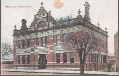
Thought to have originated in Austria in 1869, postcards first gained popularity in Australia in the 1890s.They were used to send short messages to friends and family. This collection was generated by Mary Emma Elliot of Talgarno. Talgarno is a rural locality in Victoria, Australia, situated on the southern shoreline of Lake Hume, about 23 km east of Albury-Wodonga. The collection contains postcards from across the world. Mary Emma Sibley was born in Ironbark, Bendigo in 1859. She married James Elliot in 1893 and they settled at “Kelso”, Talgarno. They had two children – Mona and Sibley. Mary Emma Elliot died in Melbourne in 1944, aged 84 years. Australian postcards collected by Mrs. James Elliot between 1898 and 1915. 1405.061 Mechanic's Institute, Albury 1405.062 Kiama, N.S.W. 1405.063 Dean Street, Albury, N.S.W. 1405.064 Union Bank and Post Office, Temora 1405.065 Middle Harbour, Sydney 1405.066 Sydney University, Sydney 1405.067 Botanic Gardens, Sydney 1405.068 Bridge Street, Sydney 1405.069 Botanic Gardens, Sydney 1405.070 the Two Bridges, Yass 1405.071 Court house, Yass 1405.072 Church of St. Augustine, Yass 1405.073 The Grotto, Church of St. Augustine, Yass 1405.074 Hume and Hovell Monument 1405.075 Flat Rock, Middle Harbour, Sydney 1405.076 the Dam, National Park, New South Wales 1405.077 Hamilton Hume's Monument, Albury Gardens 1405.078 the weir, Yass 1405.079 Lane Cove River, Sydney, N.S.W. 1405.080 Suspension Bridge, North Sydneypostcards, collecting, collections, talgarno -
 Orbost & District Historical Society
black and white photograph, first half 20th century
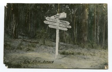
Prior to the sealing of the Princes Highway west of Orbost, the road surface was anything but good, even by C1917 when cars started to use the road. From Orbost the old road via Marlo to Sydenham was abandoned for the new location which traversed more rugged country via Cabbage Tree, Bell Bird and Club Terrace to Cann River, and the reason for this diversion was on account of settlements being established at Murrungowar and Club Terrace, at which latter place there was a temporary rush to obtain gold. This road was constructed by the Public Works department and a maximum grade of 1 in 19 was adopted, and as speed was not to be catered for the grade followed in and out round the spurs and gullies, resulting in a maze of turns and twists which required a good deal of skill on the part of the horse driver to negotiate." - Bairnsdale Advertiser, Friday, May 2, 1947. (More information from Newsletter February 2010)This is a pictorial record of an early road distance sign on a major highway through East Gippsland. The distances are indicated in miles, a measurement standard no longer in use.A black / white photograph postcard of the signpost at the Victorian - New South Wales border. It shows distances to Sydney and Eden on one arrow and distances to Melbourne and Genoa on another. on front - Vic - NSW Borderprinces-highway-east-gippsland road-transport road-sign -
 Orbost & District Historical Society
black and white photograph, late 19th century - early 20th century
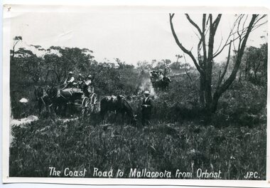
Prior to the sealing of the Princes Highway west of Orbost, the road surface was anything but good, even by C1917 when cars started to use the road. From Orbost the old road via Marlo to Sydenham was abandoned for the new location which traversed more rugged country via Cabbage Tree, Bell Bird and Club Terrace to Cann River, and the reason for this diversion was on account of settlements being established at Murrungowar and Club Terrace, at which latter place there was a temporary rush to obtain gold. This road was constructed by the Public Works department and a maximum grade of 1 in 19 was adopted, and as speed was not to be catered for the grade followed in and out round the spurs and gullies, resulting in a maze of turns and twists which required a good deal of skill on the part of the horse driver to negotiate." - Bairnsdale Advertiser, Friday, May 2, 1947. (More information from Newsletter February 2010)n the late 1800's early 1900's transporting goods by road was difficult and at times impossible because roads as thoroughfares did not exist.The means of travelling along the roads in the 1800's was by bullock wagon, horse pulled dray, pack horse or simply by foot. This road is still in use in East Gippsland as a part of many four-wheel-drive touring routes.A large black / white photograph of two horse - drawn wagons on a narrow sandy bush track. It is surrounded by scrub. There is one man standing beside a horse not harnessed to a wagon.on front - "The Coast Road to Mallacoota from Orbost JPC" -
 Warrnambool and District Historical Society Inc.
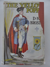
Book, The Yellow Poppy by D K Broster, 1937
This book comes from the property of Lyndoch near the mouth of the Hopkins River. George Rolfe, a tea merchant from Melbourne, established Lyndoch in 1875 and Miss Florence Lake, daughter of Miss Annie Lake, later Mrs George Rolfe, inherited the property with her sister Annie. In 1920 Florence Lake built a large house called Lyndoch. She had a Rolls Royce car and a chauffeur and was a tireless worker for local charities. Florence Lake died in 1946 and the property became the site of an Aged Care Facility in Warrnambool. Florence Lake’s house now forms part of the hostel section of this facility. This book would have been in the Lyndoch library during Florence Lake’s time there. D K Broster ( Dorothy Kathleen) was a popular writer of historical novels in the early part of the 20th century. The Flight of the heron being her most acclaimed This book is of interest as it came from the historically-important property and house known as Lyndoch and so it is connected to Miss Florence Lake, a prominent person in Warrnambool in the first half of the 20th century. This is a hard cover book of 439 pages. It has a red cover with black lettering on the front and spine. It also has a dust cover which has a colour image of a man in late 18th century attire and a shield containing a yellow poppy. The dust cover is partly torn away. The book has 46 chapters. The inscription is handwritten in black ink. ‘Lyndoch Xmas 1937’lyndoch, florence lake, history of warrnambool -
 Warrnambool and District Historical Society Inc.
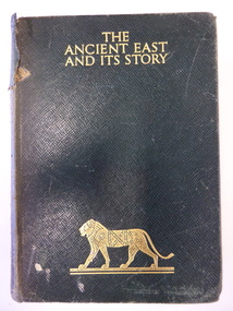
Book, The Ancient East and it's story, Mid 20th century
This book was given in 1943 by the Warrnambool Technical School to Joyce Goodall. Considering that World War Two was in progress at the time, the book was an expensive one to be given as a school prize. But the donor was Miss Florence Lake, the daughter of John and Annie Lake and the step-daughter of George Rolfe of Lyndoch, near the Hopkins River mouth. Miss Lake inherited the property and built the residence known as Lyndoch that is today part of the Lyndoch Aged Care Facility. Miss Lake was known for her philanthropy and community work in Warrnambool. John King’s name has been crossed out in the book as he was no longer Principal in 1943. He was the founding principal of Warrnambool Technical School in 1911 and remained there for 29 years. The Goodall family established Wanstead Farm in East Warrnambool in the 19th century and Joyce Goodall was descended from the Mortlake branch of that family.This book is of interest because of its association in 1943 with Joyce Goodall, Florence Lake and Warrnambool Technical School. This is a hard cover book of 472 pages. The cover is brown with gold lettering and the image of a lion on the front cover and a scroll pattern on the spine. The book has a preface, 41 chapters and an index. There are eight colour plates scattered throughout the text. The book plate on the first page is printed and pasted in and it has typed material added to it. Another inscription has been handwritten in pencil. There are also several notes and quotations handwritten in pencil on the back page. The cover is stained and torn in some places and many of the pages are stained. ‘Warrnambool Technical School, Labor to Efficiency, 8th December 1943, for Outstanding Efficiency in Art Subjects, Donated by Miss Lake, Awarded to Joyce Goodall, John King Principal’ (the name ‘John King’ has been crossed out) ‘Joyce Goodall 198 Timor Street Warrnambool’ joyce goodall, florence lake, warrnambool technical school, history of warrnambool -
 Kiewa Valley Historical Society
Photographs –Collection of 10 copies and original black and white photographs and printed articles relating to skiing on the Bogong High Plains
After World War II, the Kiewa Hydro-Electric Scheme was started in the Kiewa River Valley by the State Electricity Commission of Victoria. On land previously used only for summer cattle grazing in the natural alpine grasslands, the first ski lodge was built in 1948 by workers from the hydro scheme as skiing was a popular recreation. Many of the hydro employees were of European background and had grown up enjoying skiing and snow sports in their homelands and were keen to continue to pursue their winter sports interests. The first lift, a rope tow, was built in 1951 at Falls Creek and the first chairlift in Australia was constructed there in 1957. Two T-Bars were opened in 1961. In 1964, the Victorian Municipal Directory recorded that Falls Creek had 29 ski club lodges and 16 commercial lodges. The area became a popular tourist destination for both winter and summer sports.: Employees of the State Electricity Commission of Victoria in the Kiewa River Valley were the earliest skiers on the Bogong High Plains and built one of the first ski lodges at Falls Creek. They were amongst those pivotal in the development of the skiing and tourist industry at Falls Creek and on the Bogong High Plains. Collection of 10 copies and original black and white photographs and printed articles relating to skiing on the Bogong High Plains. Some pieces have been enlarged to A3 poster size copies for display purposes 1. Copy of black and white photograph of group of skiers at Falls Creek 2. Copy of photograph of early skier on Bogong High Plains with temporary buildings and tents in the background 3. Copy of photograph of 3 skiers on Mt McKay 4. Copy of SECV photograph of Rocky Valley Camp under snow 5. Early sepia photograph of Falls Creek village with skiers in the foreground 6. Copy of a page from booklet (SECV?) promoting the benefits of owning a holiday home in the Bogong Village area 7. Copy of a page from booklet (SECV?) promoting the benefits of holidaying in and around Falls Creek/Mt Beauty 8. Panoramic view of ski fields with skis in the foreground 9. Photograph of young skier (identity unknown) 10. Photograph of 2 male skiers (identity unknown) performing a small jump 1. Bogong Ski Club Members & Friends 1944 2. Jack Neve – electrician. Rocky Valley 3. 17.5.55 Skiers ascending Mt McKay 4. State Electricity Commission of Victoria. Date:17.8.55 No:K8132 Kiewa Hydro Electric Works. Rocky Valley Camp – From Engineering Office 5 & 9 No markings 6 & 7 Short article relating to photos on each page 8. Handwritten signature on rear of photo (Sandra Conea) 10 Faded unreadable photographers stamp and handwritten numbers 6875 on rear secv; bogong high plains; skiers; falls creek; tourism -
 Kiewa Valley Historical Society
Photographs – Bogong High Plains - Set of 16 black and white photographs mounted back and front on 3 pieces of heavy black card likely removed from a photograph album
After World War II, the Kiewa Hydro-Electric Scheme was started in the Kiewa River Valley by the State Electricity Commission of Victoria. On land previously used only for summer cattle grazing in the natural alpine grasslands, the first ski lodge was built in 1948 by workers from the hydro scheme as skiing was a popular recreation. Many of the hydro employees were of European background and had grown up enjoying skiing and snow sports in their homelands and were keen to continue to pursue their winter sports interests. The first lift, a rope tow, was built at Falls Creek in 1951 and the first chairlift in Australia was constructed there in 1957. Two T-Bars were opened in 1961. In 1964, the Victorian Municipal Directory recorded that Falls Creek had 29 ski club lodges and 16 commercial lodges. The area became a popular tourist destination for both winter and summer sports.Employees of the State Electricity Commission of Victoria in the Kiewa River Valley were the earliest skiers on the Bogong High Plains and built one of the first ski lodges at Falls Creek. They were amongst those pivotal in the development of the skiing and tourist industry at Falls Creek and on the Bogong High Plains. Black and white photographs of varying sizes mounted decoratively on heavy black Card. Some pages display a brief description printed in white ink 1. 4 photographs- displayed diagonally across page. 2 pictures of a group of men standing in the snow in front of a car with a loaded trailer behind. 1 photo of skiers. 1 photo of show hanging in tree branches. 2. 2 photographs- showing Upper Kiewa Road with snow in the background 3. 3 photographs- of skiers and 1 photo of 2 of men posing in the snow & 1 photo of 2 men posing shirtless in warmer weather. 4. 2 photographs- arranged diagonally on page showing early buildings and construction at Bogong Village 5. 2 photographs- 1 showing view of Bogong Village from higher up the mountain. 1 showing early Bogong High Plains road 6. 1 photograph- showing view down along Kiewa Valley from higher up in the mountains 1. Handwritten in white ink – A TRIP TO THE PLAINS 2. Handwritten in white ink – UPPER KIEWA ROAD MT FAINTER IN BACKGROUND 3 – 6. No markings bogong village; upper kiewa road; bogong high plains; falls creek; skiers -
 Eltham District Historical Society Inc
Photograph, Fay Bridge, Rosehill Homestead, EDHS Heritage Excursion, 6 July 2019
July Excursion July 6, 2019 - Exploring Lower Plenty The predominant feature of this walk in the Bonds Road area, Lower Plenty is the large number of magnificent old River Red Gums that line the route. These trees are of the spreading woodland form of this species indicating that they must have been originally growing in a reasonably open setting. The walk also includes parts of the historic Cleveland Estate and the homestead “Rosehill” established by pioneer farmer Henry Stooke. This area was the site of the first recorded European settlement in what was to become the Shire of Eltham when the Willis brothers arrived in the late 1830s. From the southern part of Cleveland Avenue there are extensive views across and along the Yarra Valley. An article on the history of this area was contained in Newsletter edition 201, November 2011. The walk will start at the at the corner of Bonds and Stawell Roads, Lower Plenty - EDHS Newsletter No. 246 June 2019fay bridge collection, 2019-07-06, blackburn bricks, eltham district historical society, heritage excursion, rosehill homestead, lower plenty -
 Eltham District Historical Society Inc
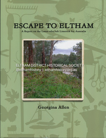
Book, Georgina Allen, Escape to Eltham: A report on the Lanes who left Limerick for Australia, 2013
ESCAPE TO ELTHAM traces the family of John and Anna Lane who lived in Shanagolden in County Limerick during the early and middle parts of the 1800s. They lived during a time of conflict and famine. This story follows the movements of their son, Richard, and daughter, Anne, who migrated to Australia. The marriage of Anne to Tobias Butler and Richard's life establishing his farm on the Yarra River in the 1850s are explored. Marriage, children, deaths and a murder in 1861 are changes forced on the family. Richard's son, Patrick, marries a young Bridget Carrucan but when the global recession of the 1890s decimates Patrick's businesses he heads to the arid Western Australian goldfields to 'make his fortune'. The large family follows and settles in Boulder where the behaviour of a couple of the boys gets them into scapes with the law. This story celebrates the tenacity of a family whose members left adversity in Ireland hoping for a kinder life in Australia.john lane, anna lane, richard lane, patrick lane, bridget carrucan -
 Eltham District Historical Society Inc
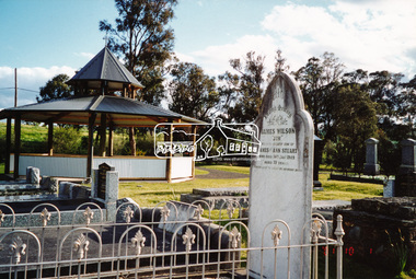
Photograph, A walk through the cemetery at Kangaroo Ground, Diana Bassett-Smith, 1 October 2001, 2001
The Kangaroo Ground Cemetery celebrated its 150th anniversary in 2001. Celebrations included the opening of a new rotunda on the 26 October 2001. Ths photo is a part of a brief collection of reminiscences by Diana Bassett-Smith of locals who are buried at Kangaroo Ground Cemetery along with 17 photographs following a visit on 1 October 2001. "One other headstone, that of James Wilson. It was a Wilson who had a nursery at the North Eastern end of Bourchiers Road on the land known as Tintagell alongside the Yarra. He grew trees, pines in particular, and supplied within the district and to the gardens of Melbourne. According to Jimmy Cook. The last of the warriors is between the gate and the river. And confirmed by Dorrie Bourchier that the original pines to what is now our property came from Wilson. The only one left now is by Passiona. Lightening claimed the one at the corner of our drive." Colour photograph printkangaroo ground cemetery, rotunda, james wilson -
 Bendigo Military Museum
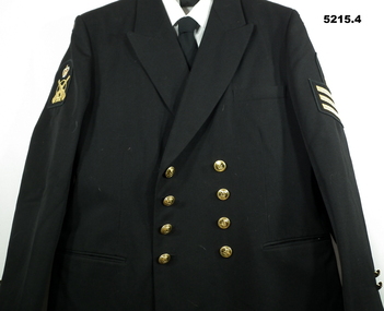
Uniform - UNIFORM, WINTER CEREMONIAL NAVY, ADA - Australian Defence Apparel, 1994-1996
David Dixon RAN R112262. Enlisted July 1972 as a Junior recruit age 15 years 9 months at HMAS Leeuwin. Passed out as Ordinary Seamen QMG and posted to HMAS Sydney 111 in Sept 1973. Jan 1974 - Feb 1981 with HMAS Derwent River Class Destroyer. Feb 1981 posted to HMAS Flinders Survey Ship. Sept 1981 promoted to Provisional Petty Officer QMG and then to HMAS Cerberus Gunnery School. Promoted to Petty Officer QMG then to HMAS Yarra 1984 then to HMAS Gladstone. Discharged from the RAN June 1987. Re Enlist 1996 and did a refresher course and posted to HMAS Success Fleet Tanker then HMAS Brisbane till 2001. Posted to HMAS Kuttabul with Recurring Back Injury and Discharged from the RAN May 2002. Total 21 years service with 17 off at Sea.1. Jacket - Black, Wool/Polyester, Insignias, yellow metal buttons. 2. Trousers - Black, Wool/Polyester. 3. Shirt - White, Polyester/Cotton. 4. Tie - Black, Polyester/Viscose. 5. Officers Peaked Cap - Plastic, White and Black, polyester, Elasticised band, Petty Officer Insignia.1. On Jacket - 3 stipes in gold braid. Petty Officer Insignia on Left Shoulder. Category Insignia on Right shoulder - Quartermaster Gunner.uniform, navy -
 Greensborough Historical Society
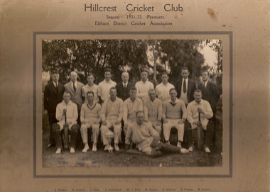
Photograph (copy), Hillcrest Cricket Club: photograph and article, 1931-1932
The Hillcrest Cricket Club is shown in the 1931-32 season. The photograph is named. The photo is accompanied by a handwritten short history of the club by Ray Hooper: "Hillcrest C.C.- Hillcrest Cricket Club was situated between Mountainview Road and … Street at the top of the hill. Where it became flat more or less where River Street met Mountainview Road (straight up). The land was owned by Mr J Ellis (senior) who allowed the local men to make a cricket pitch so they could form a cricket team and enter in the Eltham District Cricket Association (1925-1930). As you can see Mr Ellis Senior (by photo) became president and both his sons played for Hillcrest C.C. My father also played and I can just remember W Mills (Captain), H.Padget, H.Johnson, J.Parks and H.Weidlich (as I got older). Ray Hooper." Copy of group photograph and handwritten article.Group photograph is named.hillcrest cricket club, ray hooper -
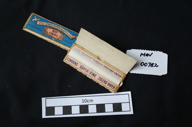 City of Moorabbin Historical Society (Operating the Box Cottage Museum)
Manufactured objects, Cigarette papers ‘Zig Zag' x 2, 20thC
Rolling papers are small sheets, rolls, or leaves of paper which are sold for rolling cigarettes either by hand or with a rolling machine. When rolling a cigarette, one fills the rolling paper with tobacco. Rolling papers are most commonly made with wood pulp, hemp, flax, or rice straw as a base material. Zig-Zag papers, made in France, were the first interleaved brand (hence the name). Gold medal at 1900 Universal Exposition in Paris. 1860 Samuel Ramsden, a Yorkshire man, founded first paper mill in Victoria on the banks of the Yarra River, Fairfield, Melbourne. This was the Australian Paper and Pulp Company which for most of its history was called The Australian Paper Manufacturers Ltd. until it changed its name in 1986 to Amcor. In 1919 the company opened its mill on the corner of Upper Heidelberg Road and The Chandler Highway in Fairfield and remains there today. 2 packets of precut cigarette papers 'Zig Zag ' Paper Aust. Pty. Ltd. 60 leavesZIG ZAG PAPER AUST. PTY LTD 60 LEAVESciggarettes, cigarette papers, tobacco, moorabbin, cheltenham, early settlers, australian paper manufacturers, fairfield melbourne, zig zag cigarette papers ltd. amcor ltd, -
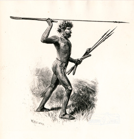 Eltham District Historical Society Inc
Photograph, Sketch of Aboriginal man with spears by W. Macleod
This black and white image appears on page 9 "Painters and Pioneers: One hundred years of Eltham and its Shire" by Alan Marshall (1971). (It is incorrectly acknowledged as S.T. Gill in the acknowledgements). It relates to Chapter 1 "The Beginning" and the description of explorer's Joseph Gellibrand journey through the area (and beyond) of the area now known as Eltham and wider Shire of Nillumbik. Gellibrand was accompanied by male aborigines. William Macleod (1850-1929) was a contributor to the "Picturesque Atlas of Australia" 1886. Described in "The Daily Telegraph" 21 June 1924 :"Macleod is a preserver of the scenic records of his own time, inasmuch as he has furnished posterity with many view of towns, rivers, and other localities, as they appeared in the years 1886-8. Among these, he has given us ...a blackfellow throwing a spear...' Image first published 1886. Image re-published in "Painters and Pioneers", 1971 pioneers and painters, aborigine, spear, drawing, william macleod, picturesque atlas of australia, aboriginal australian -
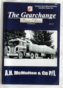 Orbost & District Historical Society
book, The Gearchange, C 2015
The American Truck History Association is an international organization, with over 21,000 members in the United States, Australia, Canada, and 20 other countries worldwide. A.H. McMullen & Co P/L, established by Arthur McMillan in February, 1951, had a long history as transport operators in Orbost and Gippsland districts. The company became Gippsland's largest transport company. It carted timber from the Orbost/ Cann River district district sawmills to the railway station. Two trains a day left the sloaded with timber. Beans were carted from Fisher's Bean Factory to Melbourne and Sydney. Cream from the farms was transported to the butter factory and for almost twenty years Fuel was carted from Melbourne to the RAAF base at Sale by McMullens. In 1970 the company was sold to F.J. Stephens and then to Mayne Nickless Transport. (ref.Deborah Hall "In Times Gone By') A.H. McMullen was a significant business in the mid 20th century in Orbost. This book is a useful reference source.A 40pp book with a dark blue cover titled "The Gearchange". It is a "Classic Edition Issue No. 2" and features A.H. McMullan & C0 P/L. It has a cost of $20.00. It contains illustrations, photographs and text.transport mcmullen-transport-orbost trucking -
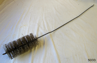 Flagstaff Hill Maritime Museum and Village
Equipment - Pipe Brush
This ship's boiler pipe brush would have been used to keep the steam boiler pipes in good working order. The bristles are arranged in a round shape to fit against the sides of the boiler pipe and clear away debris. The brush has a loop for storing it on a hook so the bristles won't become damaged. The ship's boilers created steam to power the ship's engines. Some larger steamships had several boilers and therefore several funnels. Early steamships also have masts and sails, giving them the option of steam power or wind power. The first successful steamboat trial in America was in 1787 when John Finch displayed its features on the Delaware River in Philadelphia. The first steamboat in Australia was the Sophia Jane, which arrived in Sydney in 1831. The ship traded cargo and passengers between Sydney and Newcastle. This ship's boiler pipe brush is unique in our collection and an essential item in the maintenance of steam boilers. It is connected to the era of steamships, which in Australia began in 1831 with the arrival of the first steamship in Sydney. Pipe brush; long twisted wire handle with stiff bristles around the base section, arranged in a cylindrical shape, and a loop at the other end. Used for cleaning pipes of a ships boiler.warrnambool, shipwreck coast, flagstaff hill, flagstaff hill maritime museum, flagstaff hill maritime village, steam boiler, steam boiler brush, boiler maintenance, boiler brush, pipe brush, steam boiler pipe, steamship, steamboat, steam power -
 Coal Creek Community Park & Museum
Bottle, glass, c. 1942-1951
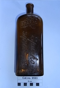
TROVE : Weekly Times (Melbourne, Vic. : 1869 - 1954), Wednesday 17 June 1942, page 13 '…………… CHANDLER'S for Better Value!............ "SPARKO" SELF POLISHING WAX . . . . at 1/- large bottle…... (D. & W. CHANDLER LTD.) 276 BRUNSWICK STREET, FITZROY. J4145 (7 lines) 234 FLINDERS LANE, MELBOURNE. T4175 (4 lines) VICTORIA MARKET, BALLARAT. COLAC, HORSHAM, WANGARATTA, WARRNAMBOOL'. TROVE :Age (Melbourne, Vic. : 1854 - 1954), Saturday 15 September 1951, page 28 ‘…… TRAVELLERS calling on country stores in Victoria. We have an excellent line. Apply Sparko Speciality Sales Service, 17 Perry-street, Collingwood. JA3042. — TRAVELLERS, calling north of the river, we have additional lines, contact Sparko Specialty Sales Service, 17 Perry-street, Collingwood. JA3042……………………’ Brown rectangular bottle for stopper seal, with ridged pattern of ridges on both sides and back. Text embossed around base , on two sides at the shoulder, on the front side and on base.Embossed on rear shoulder 'POISONOUS NOT TO BE TAKEN', running around the four sides at bottom 'THE PROPERTY OF SPARKO SPECIALITY SALES SERVICE', on front at shoulder, a logo of a silhouette of Australia with a band diagonally across containing the word 'SPARKO'. on front running down the bottle 'Sparko Self Polishing Wax'. On base AGM logo, 'F451', 'D45', 'M. on edge of base '34A' in mirror text. -
 City of Whittlesea
Document - Correspondence, Council letter to Mrs Moses Thomas 1868, 1878
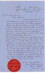
In 1851 Moses Thomas purchased 400 acres, including a half mile frontage to the Plenty River, at Mernda (then known as Morang) where he operated a farm, inn and other business. In 1865 Moses Thomas was appointed Engineer, Clerk and Collector for the Morang District Road Board. In this role he would have been responsible for overseeing the collection of local property rates and the maintenance and construction of local roads and drains. Road District Boards were one of the earliest forms of local government in Victoria. The Morang or Upper Plenty Road District was established in 1862. It covered part of what is today Mernda, Doreen, South Morang, Mill Park and Bundoora. In 1875, the area merged with the Whittlesea Road District to form the Shire of Whittlesea. Moses Thomas briefly served as a Councillor with the Shire of Whittlesea until his death in 1878. Correspondence. Letter, paper, handwritten text with seal. Letter from James Ryan, Shire Secretary, Shire of Whittlesea to Mrs Moses Thomas on the death of Moses 18 May 1878. -
 Chiltern Athenaeum Trust
Domestic object, Stewart Dawson and Co, Unknown
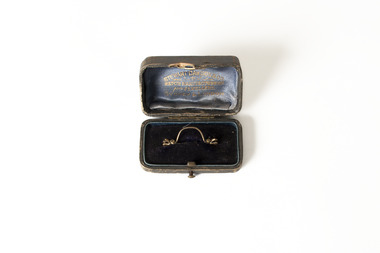
Wilfred Clarence Busse was born in Chiltern, Victoria in 1898. His family first arrived in this region during the gold rush era, purchasing a piece of land adjacent to the Murray River. The spectacular scenery and rich history of the area is said to have inspired Busse in his writing. He attended Wesley College in his school days, before going on to study law at the University of Melbourne. After graduating from university, Busse would go on to become a barrister, but he is best known as a writer of fiction, publishing two novels: 'The Blue Beyond: A Romance of the Early Days in South Eastern Australia' and 'The Golden Plague: A Romance in the Early Fifties'. Busse died in 1960. This particular object was owned by Busse. It is a tie pin and, as inscribed on its box, it was manufactured by Stewart Dawson and Co, a successful jewellery company - founded in Sydney in the late nineteenth century - that is still active today. This object is significant as it was owned by Wilfred Clarence Busse, an accomplished barrister and writer from Chiltern, Victoria. It was also manufactured by Stewart Dawson and Co, a successful jewellery company, founded in the nineteenth century, that is still active today. A thin, curved, gold-coloured tie pin placed inside an open velvet-lined jewellery box. Inscribed beneath the lid are the words 'Stewart Dawson and Co. / Watch Manufacturers / and Jewellers / Sydney & London.Box open: Stewart Dawson and Co. / Watch Manufacturers / and Jewellers / Sydney & London w.c. busse, wilfred clarence busse, gold rush, gold rush chiltern, busse barrister, busse author, "the golden plague: a romance of the early fifties., "the golden plague”, "the blue beyond: a romance of the early days in south eastern australia", "the blue beyond", tie pin, jewellery, jewellery manufacturers, sydney jewellers nineteenth century, stewart dawson and co -
 Ballarat Heritage Services
Photograph - Photograph - Colour, Clare Gervasoni, Tarilta, 2017, 16/07/2017
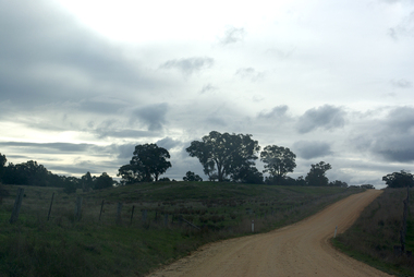
Tarilta is a rural locality and former gold-mining town 12 km south of Castlemaine, 4 km north-west of Guildford and 3 km north-east of Vaughan. The last gold mining activity took place around the 1880s. It was originally Kangaroo Flat, being located where the Kangaroo Creek enters the Loddon River. It was surveyed and named in 1864. Gold was discovered at Tarilta in 1853. The Tarilta School was opened in 1860 in a Wesleyan chapel, and closed i n1925. In 1864 a township was surveyed and named Tarilta, the word being derived from an Aboriginal expression thought to mean kangaroo. In 1865 Bailliere’s Victorian gazetteer described Tarilta as being an alluvial and quartz gold-mining town with three quartz-crushing mills, three horse-puddling machines and two hotels. The elevated nature of the land around Tarilta made it accessible only by horse and dray, or on horseback. Colour photograph of Tarilta in Central Victoria. tarilta, central victoria, landcape