Showing 783 items
matching indigenous
-
 The Beechworth Burke Museum
Photograph, c1930
Taken on 25 October 1930, various houses with the Hume Dam under construction are depicted in the background. The construction of the Hume Dam took place from 1919 to 1936. At the time of construction, it was the second largest dam in the world. It was also one of the earliest civil projects developed after the Federation. Some of the Dam workers consisted of World War I veterans. Dam workers often settled their families in Mitta Junction Village and Wodonga. Archaeological surveys were completed by Austral Archaeology, which was done when the Department of Land & Water Conservation was doing work to improve Hume Dam. The archaeological report that came out of the survey recommended three sites of interest where archaeological excavation should be done: Camp Ganger’s Quarters, Stableman’s Quarters, and the Industrial Dump. The excavation uncovered artefacts. Mitta Mitta: Mitta Mitta is situated between Mount Welcome and Mount Misery. It is named after the river that explorers Hume and Hovell discovered in 1824. The town would eventually become a huge gold mining town. Mitta Mitta is called Midamodunga by the local Indigenous peoples Wodonga: Wodonga is situated on the Murray River and is part of North East Victoria. Hume and Hovell: Hamilton Hume (1979-1873) and William Hilton Hovell (1786-1875). W. H. Hovell was born in Norfolk England and Hume was born in Parramatta, New South Wales Hovell and Hume undertook an exploration journey in 1824 and thought they discovered a river, which turned out to be the Murray River. They returned home in 1825, but returned to the area in 1826 and discovered coal in the area. This photo is historically significant as it shows the Hume Dam under construction in 1930. The Dam was named after Hamilton Hume, who is an important historical figure for this area as he helped discover the area where resources were found.Sepia rectangular photograph printed unmountedReverse: 84-19-5 / 1997.3185/ Values & spillway. / When completed the wall / will be as high as the / scaffolding. [featuring trademark: kodak print]construction, houses, veterans, mitta junction village, hume dam, world war i, federation, wodonga, archaeological survey, excavation, austral archaeology, department of land & water conservation, camp ganger's quarter's, stableman's quarters, industrial dump, artefacts, mitta mitta, mount welcome, mount misery, murray river, hamilton hume, william hilton hovell, hume and hovell expedition -
 The Beechworth Burke Museum
Photograph, c1930
Taken on 25 October 1930, various houses with the Hume Dam under construction are depicted in the background. The construction of the Hume Dam took place from 1919 to 1936. At the time of construction, it was the second largest dam in the world. It was also one of the earliest civil projects developed after the Federation. Some of the Dam workers consisted of World War I veterans. Dam workers often settled their families in Mitta Junction Village and Wodonga. Archaeological surveys were completed by Austral Archaeology, which was done when the Department of Land & Water Conservation was doing work to improve Hume Dam. The archaeological report that came out of the survey recommended three sites of interest where archaeological excavation should be done: Camp Ganger’s Quarters, Stableman’s Quarters, and the Industrial Dump. The excavation uncovered artefacts. Mitta Mitta: Mitta Mitta is situated between Mount Welcome and Mount Misery. It is named after the river that explorers Hume and Hovell discovered in 1824. The town would eventually become a huge gold mining town. Mitta Mitta is called Midamodunga by the local Indigenous peoples Wodonga: Wodonga is situated on the Murray River and is part of North East Victoria. Hume and Hovell: Hamilton Hume (1979-1873) and William Hilton Hovell (1786-1875). W. H. Hovell was born in Norfolk England and Hume was born in Parramatta, New South Wales Hovell and Hume undertook an exploration journey in 1824 and thought they discovered a river, which turned out to be the Murray River. They returned home in 1825, but returned to the area in 1826 and discovered coal in the area.This photo is historically significant as it shows the Hume Dam under construction in 1930. The Dam was named after Hamilton Hume, who is an important historical figure for this area as he helped discover the area where resources were found.Sepia rectangular photograph printed unmountedReverse: 84-19-2/ 1997.3188/ These are the four / release valves they are / not always open (illegible) this / when closed the water flows / over the spillway. [featuring trademark: kodak print] photograph number: 354construction, houses, veterans, mitta junction village, hume dam, world war i, federation, wodonga, archaeological survey, excavation, austral archaeology, department of land & water conservation, camp ganger's quarter's, stableman's quarters, industrial dump, artefacts, mitta mitta, mount welcome, mount misery, murray river, hamilton hume, william hilton hovell, hume and hovell expedition -
 The Beechworth Burke Museum
Photograph, 25 October 1930
Taken on 25 October 1930, various houses with the Hume Dam under construction are depicted in the background. The construction of the Hume Dam took place from 1919 to 1936. At the time of construction, it was the second largest dam in the world. It was also one of the earliest civil projects developed after the Federation. Some of the Dam workers consisted of World War I veterans. Dam workers often settled their families in Mitta Junction Village and Wodonga. Archaeological surveys were completed by Austral Archaeology, which was done when the Department of Land & Water Conservation was doing work to improve Hume Dam. The archaeological report that came out of the survey recommended three sites of interest where archaeological excavation should be done: Camp Ganger’s Quarters, Stableman’s Quarters, and the Industrial Dump. The excavation uncovered artefacts. Mitta Mitta: Mitta Mitta is situated between Mount Welcome and Mount Misery. It is named after the river that explorers Hume and Hovell discovered in 1824. The town would eventually become a huge gold mining town. Mitta Mitta is called Midamodunga by the local Indigenous peoples Wodonga: Wodonga is situated on the Murray River and is part of North East Victoria. Hume and Hovell: Hamilton Hume (1979-1873) and William Hilton Hovell (1786-1875). W. H. Hovell was born in Norfolk England and Hume was born in Parramatta, New South Wales Hovell and Hume undertook an exploration journey in 1824 and thought they discovered a river, which turned out to be the Murray River. They returned home in 1825, but returned to the area in 1826 and discovered coal in the area.This photo is historically significant as it shows the Hume Dam under construction in 1930. The Dam was named after Hamilton Hume, who is an important historical figure for this area as he helped discover the area where resources were found.Sepia rectangular photograph printed unmountedReverse: 84-19-6/ 1997.3187/ The spillway [featuring trademark: kodak print] construction, houses, veterans, mitta junction village, hume dam, world war i, federation, wodonga, archaeological survey, excavation, austral archaeology, department of land & water conservation, camp ganger's quarter's, stableman's quarters, industrial dump, artefacts, mitta mitta, mount welcome, mount misery, murray river, hamilton hume, william hilton hovell, hume and hovell expedition -
 The Beechworth Burke Museum
Photograph, 25 October 1930
Taken on 25 October 1930, various houses with the Hume Dam under construction are depicted in the background. The construction of the Hume Dam took place from 1919 to 1936. At the time of construction, it was the second largest dam in the world. It was also one of the earliest civil projects developed after the Federation. Some of the Dam workers consisted of World War I veterans. Dam workers often settled their families in Mitta Junction Village and Wodonga. Archaeological surveys were completed by Austral Archaeology, which was done when the Department of Land & Water Conservation was doing work to improve Hume Dam. The archaeological report that came out of the survey recommended three sites of interest where archaeological excavation should be done: Camp Ganger’s Quarters, Stableman’s Quarters, and the Industrial Dump. The excavation uncovered artefacts. Mitta Mitta: Mitta Mitta is situated between Mount Welcome and Mount Misery. It is named after the river that explorers Hume and Hovell discovered in 1824. The town would eventually become a huge gold mining town. Mitta Mitta is called Midamodunga by the local Indigenous peoples Wodonga: Wodonga is situated on the Murray River and is part of North East Victoria. Hume and Hovell: Hamilton Hume (1979-1873) and William Hilton Hovell (1786-1875). W. H. Hovell was born in Norfolk England and Hume was born in Parramatta, New South Wales Hovell and Hume undertook an exploration journey in 1824 and thought they discovered a river, which turned out to be the Murray River. They returned home in 1825, but returned to the area in 1826 and discovered coal in the area.This photo is historically significant as it shows the Hume Dam under construction in 1930. The Dam was named after Hamilton Hume, who is an important historical figure for this area as he helped discover the area where resources were found.Black and white rectangular photograph printer unmountedReverse: 84-20-1/ 1997.3147construction, houses, veterans, mitta junction village, hume dam, world war i, federation, wodonga, archaeological survey, excavation, austral archaeology, department of land & water conservation, camp ganger's quarter's, stableman's quarters, industrial dump, artefacts, mitta mitta, mount welcome, mount misery, murray river, hamilton hume, william hilton hovell, hume and hovell expedition -
 The Beechworth Burke Museum
Photograph, 25 October 1930
Taken on 25 October 1930, various houses with the Hume Dam under construction are depicted in the background. The construction of the Hume Dam took place from 1919 to 1936. At the time of construction, it was the second largest dam in the world. It was also one of the earliest civil projects developed after the Federation. Some of the Dam workers consisted of World War I veterans. Dam workers often settled their families in Mitta Junction Village and Wodonga. Archaeological surveys were completed by Austral Archaeology, which was done when the Department of Land & Water Conservation was doing work to improve Hume Dam. The archaeological report that came out of the survey recommended three sites of interest where archaeological excavation should be done: Camp Ganger’s Quarters, Stableman’s Quarters, and the Industrial Dump. The excavation uncovered artefacts. Mitta Mitta: Mitta Mitta is situated between Mount Welcome and Mount Misery. It is named after the river that explorers Hume and Hovell discovered in 1824. The town would eventually become a huge gold mining town. Mitta Mitta is called Midamodunga by the local Indigenous peoples Wodonga: Wodonga is situated on the Murray River and is part of North East Victoria. Hume and Hovell: Hamilton Hume (1979-1873) and William Hilton Hovell (1786-1875). W. H. Hovell was born in Norfolk England and Hume was born in Parramatta, New South Wales Hovell and Hume undertook an exploration journey in 1824 and thought they discovered a river, which turned out to be the Murray River. They returned home in 1825, but returned to the area in 1826 and discovered coal in the area. This photo is historically significant as it shows the Hume Dam under construction in 1930. The Dam was named after Hamilton Hume, who is an important historical figure for this area as he helped discover the area where resources were found. Black and white rectangular photograph printer unmountedReverse: 1997.3145/ 84-20-2construction, houses, veterans, mitta junction village, hume dam, world war i, federation, wodonga, archaeological survey, excavation, austral archaeology, department of land & water conservation, camp ganger's quarter's, stableman's quarters, industrial dump, artefacts, mitta mitta, mount welcome, mount misery, murray river, hamilton hume, william hilton hovell, hume and hovell expedition -
 Camperdown & District Historical Society
Photograph - James Dawson, Thomas Rodger, c1881
James Dawson (1806-1900), pastoralist, friend to First Nations people, environmentalist, patron of the Arts and author of "Australian Aborigines" (1881). Dawson came from Bonnytoun, near Linlithgow, Scotland and arrived in Melbourne with his wife, Joan Alexander Park, on 2 May 1840. They made their first home in the colony farming in Port Phillip, near Anderson's Creek on the Yarra River, where their daughter, Isabella was born in 1842, then from 1844, moved to 'Kangatong' station on the Moyne River, east of Macarthur. In 1866 the Dawsons left the Port Fairy district and lived in various residences in Melbourne. By 1868 the family had settled in Camperdown at 'Wuurong', on the banks of Lake Bullen Merri. Unlike most people at the time, Dawson and his daughter shared a deep interest in, and respect for First Nations people. In 1876 James Dawson was appointed local Guardian of the Aborigines in the Camperdown district. He was a prolific letter writer and an early advocate for indigenous rights and was dedicated to exposing injustice and the maltreatment of First Nations people. He had befriended Wombeetch Puyuun (Camperdown George) who was the last of the local Djargurd Wurrung living on Country when he died in February 1883. In 1885 James Dawson erected the Wombeetch Puyuun Monument at Camperdown Cemetery in his memory. His friend's remains were reburied at the foot of the obelisk and the two dates, 1840-1883, mark the 43 years it took for European settlement to displace the Djargurd Wurrung from the Camperdown District.Sepia photograph of an elderly James Dawson taken in Scotland. Front: T. Rodger St. ANDREWS N.B. Back: THOMAS RODGER Photographer ST. ANDREWS ETABLISHED 1849cdhs, isabella dawson, camperdown cemetery, djargurdwurrung, cdhsfirstnations -
 Camperdown & District Historical Society
Book - The James Dawson Scrapbook, c1881
James Dawson (1806-1900), pastoralist, friend to First Nations people, environmentalist, patron of the Arts and author of "Australian Aborigines" (1881). Dawson came from Bonnytoun, near Linlithgow, Scotland and arrived in Melbourne with his wife, Joan Alexander Park, on 2 May 1840. They made their first home in the colony farming in Port Phillip, near Anderson's Creek on the Yarra River, where their daughter, Isabella was born in 1842, then from 1844, moved to 'Kangatong' station on the Moyne River, east of Macarthur. In 1866 the Dawsons left the Port Fairy district and lived in various residences in Melbourne. By 1868 the family had settled in Camperdown at 'Wuurong', on the banks of Lake Bullen Merri. Unlike most people at the time, Dawson and his daughter shared a deep interest in, and respect for First Nations people. In 1876 James Dawson was appointed local Guardian of the Aborigines in the Camperdown district. He was a prolific letter writer and an early advocate for indigenous rights and was dedicated to exposing injustice and the maltreatment of First Nations people. He had befriended Wombeetch Puyuun (Camperdown George) who was the last of the local Djargurd Wurrung living on Country when he died in February 1883. In 1885 James Dawson erected the Wombeetch Puyuun Monument at Camperdown Cemetery in his memory. His friend's remains were reburied at the foot of the obelisk and the two dates, 1840-1883, mark the 43 years it took for European settlement to displace the Djargurd Wurrung from the Camperdown District.The James Dawson Scrapbookcdhs, isabella dawson, camperdown cemetery, djargurdwurrung, cdhsfirstnations -
 Camperdown & District Historical Society
Photograph - James and Joan Dawson, studio photograph, c1878
James Dawson (1806-1900), pastoralist, friend to First Nations people, environmentalist, patron of the Arts and author of "Australian Aborigines" (1881). He married Joan Alexander Park in 1877. Joan was the niece of the famous African explorer, Mungo Park. James Dawson came from Bonnytoun, near Linlithgow, Scotland and arrived in Melbourne with his wife on 2 May 1840. They made their first home in the colony farming in Port Phillip, near Anderson's Creek on the Yarra River, where their daughter, Isabella was born in 1842, then from 1844, moved to 'Kangatong' station on the Moyne River, east of Macarthur. In 1866 the Dawsons left the Port Fairy district and lived in various residences in Melbourne. By 1868 the family had settled in Camperdown at 'Wuurong', on the banks of Lake Bullen Merri. Unlike most people at the time, the Dawson's shared a deep interest in, and respect for First Nations people. In 1876 James Dawson was appointed local Guardian of the Aborigines in the Camperdown district. He was a prolific letter writer and an early advocate for indigenous rights and was dedicated to exposing injustice and the maltreatment of First Nations people. He had befriended Wombeetch Puyuun (Camperdown George) who was the last of the local Djargurd Wurrung living on Country when he died in February 1883. In 1885 James Dawson erected the Wombeetch Puyuun Monument at Camperdown Cemetery in his memory. His friend's remains were reburied at the foot of the obelisk and the two dates, 1840-1883, mark the 43 years it took for European settlement to displace the Djargurd Wurrung from the Camperdown District.Studio portrait of James and Joan Dawson taken in Australia. cdhs, isabella dawson, camperdown cemetery, djargurdwurrung, cdhsfirstnations -
 Camperdown & District Historical Society
Photograph - James Dawson, c1878
James Dawson (1806-1900), pastoralist, friend to First Nations people, environmentalist, patron of the Arts and author of "Australian Aborigines" (1881). Dawson came from Bonnytoun, near Linlithgow, Scotland and arrived in Melbourne with his wife, Joan Alexander Park, on 2 May 1840. They made their first home in the colony farming in Port Phillip, near Anderson's Creek on the Yarra River, where their daughter, Isabella was born in 1842, then from 1844, moved to 'Kangatong' station on the Moyne River, east of Macarthur. In 1866 the Dawsons left the Port Fairy district and lived in various residences in Melbourne. By 1868 the family had settled in Camperdown at 'Wuurong', on the banks of Lake Bullen Merri. Unlike most people at the time, Dawson and his daughter shared a deep interest in, and respect for First Nations people. In 1876 James Dawson was appointed local Guardian of the Aborigines in the Camperdown district. He was a prolific letter writer and an early advocate for indigenous rights and was dedicated to exposing injustice and the maltreatment of First Nations people. He had befriended Wombeetch Puyuun (Camperdown George) who was the last of the local Djargurd Wurrung living on Country when he died in February 1883. In 1885 James Dawson erected the Wombeetch Puyuun Monument at Camperdown Cemetery in his memory. His friend's remains were reburied at the foot of the obelisk and the two dates, 1840-1883, mark the 43 years it took for European settlement to displace the Djargurd Wurrung from the Camperdown District.Side portrait of an elderly James Dawson. cdhs, isabella dawson, camperdown cemetery, djargurdwurrung, cdhsfirstnations -
 Eltham District Historical Society Inc
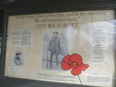
Photograph, Liz Pidgeon, Moor-Rul Viewing Platform Panel: Lest We Forget, 10 August 2016
Includes photograph of WW1 local enlistment John Bell. The Moor-Rul Viewing Platform, part of the Kangaroo Ground War Memorial Park opened in April 2007. Eight double-sided interpretation panels on the Moor-rul viewing platform highlight the area's Aboriginal and European history of the area and also details of local geology, flora and fauna. These panels feature high quality graphic design and professionally written text. The subjects covered are: ''Womin Je Ka" Welcome The Kulin Nation Singing, Dancing, Ceremony, Celebration This Country, My Home The Highland Taken Auld Lang Syne "Same Land Different Views" Working the Land Food from the Earth or "Earth's Harvest" Lest We Forget, "And with the going down of the Sun .... (3 panels) This Black Earth Those other indigenous inhabitants - Kangaroo Ground's Wildlife Silent Witnesses - Kangaroo Ground's White Manna Gums Belonging A Place of Reverence and A Tower of Strength Souce: EDHS Newsletter No 173 March 2007. As part of a program to acknowledge the Anzac Centenary Nillumbik Shire Council partnered with Yarra Plenty Regional Library to provide a bus tour with commentary of local sites of significance: Shire of Nillumbik World War One Memorials tour, 10 August 2016. These included Eltham township, the Shire of Eltham War Memorial at Kangaroo Ground, Christmas Hills war memorial, Hurstbridge memorial recreation park and finshed at Eltham Library to view the Writing the War exhibtion at Eltham Library Community Gallery.Born Digitalworld war 1, war memorials, shire of nillumbik, moor-rul viewing platform, interpretation panel, interpretative signage, lest we forget, shire of eltham war memorial, john bell, display panel -
 Eltham District Historical Society Inc
Photograph, Liz Pidgeon, Moor-Rul Viewing Platform Panel: Lest We Forget, 10 August 2016
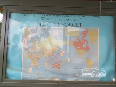
Coloured map of the world on blue including the words for the "Lest We Forget" lament. The Moor-Rul Viewing Platform, part of the Kangaroo Ground War Memorial Park opened in April 2007. Eight double-sided interpretation panels on the Moor-rul viewing platform highlight the area's Aboriginal and European history of the area and also details of local geology, flora and fauna. These panels feature high quality graphic design and professionally written text. The subjects covered are: ''Womin Je Ka" Welcome The Kulin Nation Singing, Dancing, Ceremony, Celebration This Country, My Home The Highland Taken Auld Lang Syne "Same Land Different Views" Working the Land Food from the Earth or "Earth's Harvest" Lest We Forget, "And with the going down of the Sun .... (3 panels) This Black Earth Those other indigenous inhabitants - Kangaroo Ground's Wildlife Silent Witnesses - Kangaroo Ground's White Manna Gums Belonging A Place of Reverence and A Tower of Strength Souce: EDHS Newsletter No 173 March 2007. As part of a program to acknowledge the Anzac Centenary Nillumbik Shire Council partnered with Yarra Plenty Regional Library to provide a bus tour with commentary of local sites of significance: Shire of Nillumbik World War One Memorials tour, 10 August 2016. These included Eltham township, the Shire of Eltham War Memorial at Kangaroo Ground, Christmas Hills war memorial, Hurstbridge memorial recreation park and finshed at Eltham Library to view the Writing the War exhibtion at Eltham Library Community Gallery. Born Digitalworld war 1, war memorials, shire of nillumbik, moor-rul viewing platform, kangaroo ground, shire of eltham war memorial, interpretative signage, interpretation panel, map, display panel -
 Eltham District Historical Society Inc
Photograph, Liz Pidgeon, Moor-Rul Viewing Platform Panel: This Black Earth, 10 August 2016
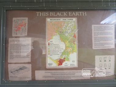
"Melbourne soil types" The Moor-Rul Viewing Platform, part of the Kangaroo Ground War Memorial Park opened in April 2007. Eight double-sided interpretation panels on the Moor-rul viewing platform highlight the area's Aboriginal and European history of the area and also details of local geology, flora and fauna. These panels feature high quality graphic design and professionally written text. The subjects covered are: ''Womin Je Ka" Welcome The Kulin Nation Singing, Dancing, Ceremony, Celebration This Country, My Home The Highland Taken Auld Lang Syne "Same Land Different Views" Working the Land Food from the Earth or "Earth's Harvest" Lest We Forget, "And with the going down of the Sun .... (3 panels) This Black Earth Those other indigenous inhabitants - Kangaroo Ground's Wildlife Silent Witnesses - Kangaroo Ground's White Manna Gums Belonging A Place of Reverence and A Tower of Strength Souce: EDHS Newsletter No 173 March 2007. As part of a program to acknowledge the Anzac Centenary Nillumbik Shire Council partnered with Yarra Plenty Regional Library to provide a bus tour with commentary of local sites of significance: Shire of Nillumbik World War One Memorials tour, 10 August 2016. These included Eltham township, the Shire of Eltham War Memorial at Kangaroo Ground, Christmas Hills war memorial, Hurstbridge memorial recreation park and finshed at Eltham Library to view the Writing the War exhibtion at Eltham Library Community Gallery.Born Digitalshire of nillumbik, moor-rul viewing platform, interpretative signage, interpretation panel, display panel -
 Eltham District Historical Society Inc
Photograph, Liz Pidgeon, Moor-Rul Viewing Platform Panel: Belonging, 10 August 2016
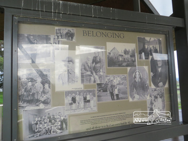
Collage of black and white historical photographs of people. The Moor-Rul Viewing Platform, part of the Kangaroo Ground War Memorial Park opened in April 2007. Eight double-sided interpretation panels on the Moor-rul viewing platform highlight the area's Aboriginal and European history of the area and also details of local geology, flora and fauna. These panels feature high quality graphic design and professionally written text. The subjects covered are: ''Womin Je Ka" Welcome The Kulin Nation Singing, Dancing, Ceremony, Celebration This Country, My Home The Highland Taken Auld Lang Syne "Same Land Different Views" Working the Land Food from the Earth or "Earth's Harvest" Lest We Forget, "And with the going down of the Sun .... (3 panels) This Black Earth Those other indigenous inhabitants - Kangaroo Ground's Wildlife Silent Witnesses - Kangaroo Ground's White Manna Gums Belonging A Place of Reverence and A Tower of Strength Souce: EDHS Newsletter No 173 March 2007. As part of a program to acknowledge the Anzac Centenary Nillumbik Shire Council partnered with Yarra Plenty Regional Library to provide a bus tour with commentary of local sites of significance: Shire of Nillumbik World War One Memorials tour, 10 August 2016. These included Eltham township, the Shire of Eltham War Memorial at Kangaroo Ground, Christmas Hills war memorial, Hurstbridge memorial recreation park and finshed at Eltham Library to view the Writing the War exhibtion at Eltham Library Community Gallery.Born Digitalshire of nillumbik, moor-rul viewing platform, kangaroo ground, interpretative signage, interpretation panel, display panel -
 Eltham District Historical Society Inc
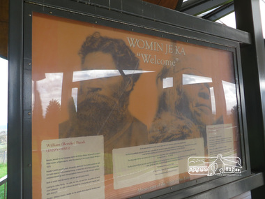
Photograph, Liz Pidgeon, Moor-Rul Viewing Platform Panel: Womin Je Ka "Welcome", 10 August 2016
Welcome panel including information on William Barak. The Moor-Rul Viewing Platform, part of the Kangaroo Ground War Memorial Park opened in April 2007. Eight double-sided interpretation panels on the Moor-rul viewing platform highlight the area's Aboriginal and European history of the area and also details of local geology, flora and fauna. These panels feature high quality graphic design and professionally written text. The subjects covered are: ''Womin Je Ka" Welcome The Kulin Nation Singing, Dancing, Ceremony, Celebration This Country, My Home The Highland Taken Auld Lang Syne "Same Land Different Views" Working the Land Food from the Earth or "Earth's Harvest" Lest We Forget, "And with the going down of the Sun .... (3 panels) This Black Earth Those other indigenous inhabitants - Kangaroo Ground's Wildlife Silent Witnesses - Kangaroo Ground's White Manna Gums Belonging A Place of Reverence and A Tower of Strength Souce: EDHS Newsletter No 173 March 2007. As part of a program to acknowledge the Anzac Centenary Nillumbik Shire Council partnered with Yarra Plenty Regional Library to provide a bus tour with commentary of local sites of significance: Shire of Nillumbik World War One Memorials tour, 10 August 2016. These included Eltham township, the Shire of Eltham War Memorial at Kangaroo Ground, Christmas Hills war memorial, Hurstbridge memorial recreation park and finshed at Eltham Library to view the Writing the War exhibtion at Eltham Library Community Gallery. Born Digitalshire of nillumbik, memorial park, kangaroo ground, interpretative signage, indigenous history, moor-rul viewing platform, william barak, display panel -
 Eltham District Historical Society Inc
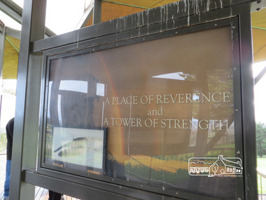
Photograph, Liz Pidgeon, Moor-Rul Viewing Platform Panel: A Place of Reverence and a Tower of Strength, 10 August 2016
The Moor-Rul Viewing Platform, part of the Kangaroo Ground War Memorial Park opened in April 2007. Eight double-sided interpretation panels on the Moor-rul viewing platform highlight the area's Aboriginal and European history of the area and also details of local geology, flora and fauna. These panels feature high quality graphic design and professionally written text. The subjects covered are: ''Womin Je Ka" Welcome The Kulin Nation Singing, Dancing, Ceremony, Celebration This Country, My Home The Highland Taken Auld Lang Syne "Same Land Different Views" Working the Land Food from the Earth or "Earth's Harvest" Lest We Forget, "And with the going down of the Sun .... (3 panels) This Black Earth Those other indigenous inhabitants - Kangaroo Ground's Wildlife Silent Witnesses - Kangaroo Ground's White Manna Gums Belonging A Place of Reverence and A Tower of Strength Souce: EDHS Newsletter No 173 March 2007. This panel includes a frame of an eagle feather. See ID 02224-47 As part of a program to acknowledge the Anzac Centenary Nillumbik Shire Council partnered with Yarra Plenty Regional Library to provide a bus tour with commentary of local sites of significance: Shire of Nillumbik World War One Memorials tour, 10 August 2016. These included Eltham township, the Shire of Eltham War Memorial at Kangaroo Ground, Christmas Hills war memorial, Hurstbridge memorial recreation park and finshed at Eltham Library to view the Writing the War exhibtion at Eltham Library Community Gallery.Born Digitalshire of nillumbik, kangaroo ground, moor-rul viewing platform, interpretative signage, interpetation panel, display panel -
 Eltham District Historical Society Inc
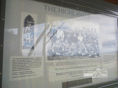
Photograph, Liz Pidgeon, Moor-Rul Viewing Platform Panel: The Highland Taken, 10 August 2016
"The Scots were the first Europeans to farm this place". The Moor-Rul Viewing Platform, part of the Kangaroo Ground War Memorial Park opened in April 2007. Eight double-sided interpretation panels on the Moor-rul viewing platform highlight the area's Aboriginal and European history of the area and also details of local geology, flora and fauna. These panels feature high quality graphic design and professionally written text. The subjects covered are: ''Womin Je Ka" Welcome The Kulin Nation Singing, Dancing, Ceremony, Celebration This Country, My Home The Highland Taken Auld Lang Syne "Same Land Different Views" Working the Land Food from the Earth or "Earth's Harvest" Lest We Forget, "And with the going down of the Sun .... (3 panels) This Black Earth Those other indigenous inhabitants - Kangaroo Ground's Wildlife Silent Witnesses - Kangaroo Ground's White Manna Gums Belonging A Place of Reverence and A Tower of Strength Souce: EDHS Newsletter No 173 March 2007. As part of a program to acknowledge the Anzac Centenary Nillumbik Shire Council partnered with Yarra Plenty Regional Library to provide a bus tour with commentary of local sites of significance: Shire of Nillumbik World War One Memorials tour, 10 August 2016. These included Eltham township, the Shire of Eltham War Memorial at Kangaroo Ground, Christmas Hills war memorial, Hurstbridge memorial recreation park and finshed at Eltham Library to view the Writing the War exhibtion at Eltham Library Community Gallery.Born Digitalshire of nillumbik, kangaroo ground, moor-rul viewing platform, interpretative signage, interpretation panel, indigenous history, display panel, early settlers -
 Nillumbik Shire Council
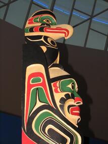
Public Art: Wayne ALFRED (b.1958 Alert Bay, British Columbia), Wayne Alfred C/- High Commision of Canada, Commonwealth Games Totem Pole, Location: Eltham Library Foyer, Panther Place, Eltham, 2006
Wayne Alfred is a member of the Namgis Tribe of the Kwakwaka'wakw people. As a master carver he has an extremely high level of carving skill and knowledge about his peoples cultural objects, customs, tribal stories and legends. The Totem Poles of the North Pacific Coast in British Columbia and Alaska are traditionally carved out of red or yellow cedar, which has a spiritual and practical purpose. The wood was known for its durability, its resistance to rotting and the inner bark was utilised in ropemaking, clothing, hats, baskets and so forth. The Kwakitul People consider the cedar tree to be among the most sacred of all things provided by the Creator. They believed the Cedar tree to be the axis of the world and a pathway to the upper world. The wood is shaped using implements such as adzes, axes, chisels, carving knives, and chainsaws. Misinterpreted as Gods and idols to be worshipped, totems usually serve six purposes, such as a house pillar for support, a memorial or mortuary pole to commemorate (and house) the deceased, a potlatch pole (used for important traditional indigenous celebrations), a ridicule pole used to shame and a heraldic or family crest pole. Characters and symbols on these totem poles usually display family crests, history, wealth, social rank, inheritance, and privilege, as well as animalistic imagery derived from native animals and mythological creatures. Their sequence are indicative of past family events, ancestors, myths, and heraldic crests, with the bottom figure usually being the most prominent. In this work the 'thunderbird' is symbolic of power, strength and of ancestory. The Commonwealth Games Totem Pole was presented to the people of Nillumbik on behalf of the Canadian Government in recognition of Melbourne as the hosts of the Melbourne Commonwealth Games Team in 2006. Carved in cedar wood, this totem pole incorporates bold cuts and colours (such as red and green) offset by strong black. A relative degree of realism is used to depict the alligator located on the bottom of the pole, a man and a 'thunderbird'/eagle located on the top. With protuding element. No inscriptions. Bold cuts used to outline the characters and symbols as well as decorative and stylised features all over the pole. public art, kwakwaka'wakw, namgis, alfred, north pacific coast, british columbia, canada, totem pole, carved, commonwealth games, melbourne festival, cedar -
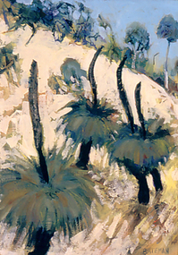 Nillumbik Shire Council
Painting: Piers BATEMAN (b.1947, Perth - d.2015, NSW), Piers Bateman, Blackboys, 1989
Piers Bateman was a local artist, held in very high esteem by his peers and community. He was born in Perth in 1947, moving to Eltham in 1955 as a young child with his family. In 1966 Bateman moved to London for eighteen months to develop his craft. In 1969 he settled in St Andrews, where he built a studio. The St Andrews locale is said to have been a strong influence on his work. Bateman’s talent was such that he was promoted and mentored by such ilk as Charles Blackman, Clifton Pugh and Arthur Boyd, among others. Bateman’s work is an intimate dialogue with the environment, renowned for his paintings of the outback, wilderness frontiers and the sea. He spent a year in the mid-seventies sailing the Greek Islands and the French canals to Amsterdam. In 1980 Bateman and Marcus Skipper embarked on a trans-Australian venture to the red centre and across northern Australia from Cairns to Broome. In the mid-eighties Bateman returned to the Mediterranean, before returning to the Australian outback in the late-eighties. His international career continued on an upwards trajectory between the Australian outback and European seas, providing a unique contrast throughout the course of his career. Bateman's work questions our relationship with the natural world, and in particular, reconciling our colonial heritage with our indigenous past. This line of questioning and his genuine response to place is the key to Piers Bateman’s work, for which he is lauded and celebrated. On September 4th 2015, Piers Bateman died in a boating accident on the NSW coast line. Piers Bateman was an instinctive painter whose inspiration came from nature. He reworked and scraped off the paint, moving it around until forms and colours of the landscape took shape. Although Bateman lived in Spain and Italy, his time in Europe made him aware of the contrast between the two continents and the bright clear light that defined the Australian landscape. At the time of this work, Bateman was living in St. Andrews, but travelled regularly to New South Wales and South Australia on painting trips. The ‘Grass Tree’ Xanthorrhoea johnsonii (commonly known as ‘blackboy’) is indigenous to these areas. It is a uniquely Australian, slow growing plant with twenty-eight species growing within Australia. Old examples of this tree are survivors of many wild fires, which can cause their blackened trunk, of one to two metres, branch into two or more heads. These heads consist of thick, rough corky bark, surrounded by long, wiry leaves and flowers that produce seed capsules with hard black seeds. The tree’s ability to be one of the first to flower after a wild fire ensures a food source for many insects and birds.Oil on canvas painting. Detail of three grass trees resting on the side of a mountain/hill. Green and gold palette throughout depicting the colours and light of the Australian landscape. Hand written, low right in capitals: 'BATEMAN'bateman, grass trees, xanthorrhoea johnsonii, landscape -
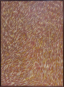 Federation University Art Collection
Painting - Artwork - painting, 'Grass Seeds' by Barbara Weir, 1999
Barbara Weir (b. 1945-03/01/2023) Born: In the region of Utopia, North East of Alice Springs, formerly known as Derry Downs Station Language: Anmatyerre and Alywarr Country: Atnwengerrp, Utopia Region, North East of Alice Springs, Northern Territory One of the Stolen Generation, Barbara Weir was removed from her Aboriginal family at the age of nine, and she was raised in a series of foster homes. Reuniting with her mother, Minnie Pwerle, in the 1960s, Weir eventually returned to her family territory of Utopia, 300 kilometres northeast of Alice Springs. Active in the local land rights movement of the 1970s Barbara Weir was elected the first woman president of the Indigenous Urapunta Council in 1985. Barbara’s career as an artist was inspired by the dynamic community of artists at Utopia and the work of her adopted auntie Emily Kame Kngwarreye. Highly experimental in her approach, Barabara Weir tried many mediums before travelling to Indonesia in 1994 with other artists to explore batik technique. She returned full of ideas on how to develop her own style which has since evolved to a more expressive abstract form. Grass Seed is part of her Dreamings and is associated with women’s ceremony and the activity of food gathering of local seeds, grasses, berries, potato, plum, banana, flowers and yams. This item is part of the Federation University Art Collection. The Art Collection features over 1000 works and was listed as a 'Ballarat Treasure' in 2007.Barbara Weir's paintings include representations of particular plants and "dreamings". Inspired by a small grass found in Utopia called Lyaw, Munyeroo or Pigsweed, Barbara's Grass Seed paintings consist of a series of small brush strokes that overlap and weave to create a swaying effect. This Dreaming tells the story of grass seed that is part of the bush tucker found in the region of Utopia. This seed is collected, crushed to a fine powder and is then used to make a bread, very similar to damper. The people of Utopia were still using this seed as late as the 1950s. During that time the seed grew in abundance but as the years passed there were very few good seeds to be found due to bullocks roaming the land and eating the grasses. The people then began to eat a substitute that the white man provided, and today very few Aboriginal people collect these seeds. art, artwork, barbara weir, aboriginal, dreaming, stolen generation, acrylic on linen -
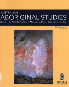 Victorian Aboriginal Corporation for Languages
Periodical, Australian Institute of Aboriginal and Torres Strait Islander Studies, Australian Aboriginal studies : journal of the Australian Institute of Aboriginal and Torres Strait Islander Studies, 2007
1. The moral lexicon of the Warlpiri people of central Australia LR Hiatt This paper discusses words that match ?Good? and ?Bad?; examples of ?Good? and ?Bad? behaviour; morality and law; and egalitarianism and dominance. It also presents a comparison with Gidjingarli (Burarra). 2. Mobs and bosses: Structures of Aboriginal sociality Patrick Mullins (Mount Druitt, NSW) A commonality of Aboriginal social organisation exists across the continent in communities as different as those from the Western Desert across to Cape York, from the towns of New South Wales and Western Australia to cities like Adelaide. This is found in the colloquial expressions ?mob? and ?boss?, which are used in widely differing contexts. Mobbing is the activity where relatedness, in the sense of social alliances, is established and affirmed by virtue of a common affiliation with place, common experience and common descent, as well as by the exchange of cash and commodities. Bossing is the activity of commanding respect by virtue of one?s capacity to bestow items of value such as ritual knowledge, nurturance, care, cash and commodities. Mobbing and bossing are best understood as structures in Giddens? sense of sets of rules and resources involved in the production of social systems, in this case social alliances. Mobbing and bossing imply a concept of a person as a being in a relationship. Attention needs to be given to the way these structures interact with institutions in the wider Australian society. 3. Recognising victims without blaming them: A moral contest? About Peter Sutton?s ?The Politics of Suffering: Indigenous Policy in Australia since the 1970s? and Gillian Cowlishaw?s replies Ma�a Ponsonnet (Universit� Paris- 8-Saint-Denis) Peter Sutton?s texts on Aboriginal violence, health and their politicisation are replied to using his methodology, and acknowledging his convincing points. Sutton rightly denounces a lack of lucidity and scientific objectivity in anthropological debates. These inadequacies impede identification of what Aboriginal groups can do to improve their situations for fear that this identification would lead to blame the victims. At the other end of the ethical spectrum, those who advocate a broader use of what I will call a ?resistance interpretation? of violence fail to recognise victims as such, on the implicit grounds that seeing victims as victims would deprive them of any agency, on the one hand, and entail blame, on the other hand. I aim to define a middle road between those views: the idea that victims should be acknowledged as such without being denied their agency and without being blamed for their own condition. This middle road allows identification of the colonisers? responsibilities in the contemporary situation of Indigenous communities in Australia, and to determine who can do what. Secondly, I show that Sutton?s texts convey, through subtle but recurrent remarks, an ideology of blame rather than a mere will to identify practical solutions. As a consequence, some of his proposals do not stand on a solid and objective causal analysis. 4. 'You would have loved her for her lore?: The letters of Daisy Bates Bob Reece (Murdoch University) Daisy Bates was once an iconic figure in Australia but her popular and academic reputation became tarnished by her retrograde views. Her credibility was also put in doubt through the exposure of her fictionalised Irish background. In more recent times, however, her ethnographic data on the Aborigines of Western Australia has been an invaluable source for Native Title claims, while her views on Aboriginal extinction, cannibalism and ?castes? are being seen as typical of her time. This article briefly reviews what has been the orthodox academic opinion of her scientific achievement before summarising what is reliably known of her early history and indicating what kind of person is revealed in the 3000 or more letters that she left behind. 5. What potential might Narrative Therapy have to assist Indigenous Australians reduce substance misuse? Violet Bacon (Curtin University of Technology) Substance misuse is associated with adverse consequences for many Australians including Aboriginal and Torres Strait Islander peoples. Extensive research has been conducted into various intervention, treatment and prevention programs to ascertain their potential in reducing substance misuse within Aboriginal and non-Aboriginal communities. I explore the potential of Narrative Therapy as a counselling intervention for assisting Indigenous Australians reduce the harm associated with substance misuse. 6. Bone points from the Adelaide River, Northern Territory Sally Brockwell (University of Canberra) and Kim Akerman (Moonah) Large earth mounds located next to the vast floodplains of the lower Adelaide River, one of the major tropical rivers draining the flat coastal plains of northern Australia, contain cultural material, including bone points. The floodplains of the north underwent dynamic environmental change from extensive mangrove swamps in the mid-Holocene, through a transition phase of variable estuarine and freshwater mosaic environments, to the freshwater environment that exists today. This geomorphological framework provides a background for the interpretation of the archaeology, which spans some 4000 years. 7. A different look: Comparative rock-art recording from the Torres Strait using computer enhancement techniques Liam M Brady (Monash University) In 1888 and 1898, Cambridge University?s Alfred C Haddon made the first recording of rock-art from the Torres Strait islands using photography and sketches. Systematic recording of these same paintings and sites was carried out from 2000 to 2004 by archaeologists and Indigenous Torres Strait Islander and Aboriginal communities as part of community-based rock-art recording projects. Computer enhancement techniques were used to identify differences between both sets of recordings, to reveal design elements that Haddon missed in his recordings, and to recover images recorded by Haddon that are today no longer visible to the naked eye. Using this data, preliminary observations into the antiquity of Torres Strait rock-art are noted along with recommendations for future Torres Strait region rock-art research and baseline monitoring projects. 8. Sources of bias in the Murray Black Collection: Implications for palaeopathological analysis Sarah Robertson (National Museum of Australia) The Murray Black collection of Aboriginal skeletal remains has been a mainstay of bio-anthropological research in Australia, but relatively little thought has been given to how and why this collection may differ from archaeologically obtained collections. The context in which remains were located and recovered has created bias within the sample, which was further skewed within the component of the collection sent to the Australian Institute of Anatomy, resulting in limitations for the research potential of the collection. This does not render all research on the collection unviable, but it demonstrates the importance of understanding the context of a skeletal collection when assessing its suitability for addressing specific research questions.maps, b&w photographs, colour photographs, illustrations, graphs, chartswarlpiri, sociology, daisy bates, substance abuse, narrative therapy, rock art, technology and art, murray black collection, pleistocene sites, watarrka plateau -
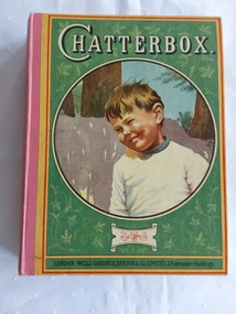 Mont De Lancey
Book, Wells Gardner, Darton & Co. Limited, Chatterbox, 1918
A vintage 1929 Chatterbox collection of puzzles, poetry and stories for children with black lined illustrations and coloured plates throughout.A vintage 1929 hardcover children's book with the title Chatterbox printed in white lettering at the top of the front cover which has a green coloured background with an illustration in a large circle showing a boy wearing a white jumper in front of trees. The publisher details are printed at the bottom. Red tape binds the covers on the spine. The faded yellow coloured back cover has an advertisement for 'Allenbury's' The Progressive System of Infant Feeding, which was a similar composition to mother's milk. The manufacturer details are added at the bottom. Inside the front cover are black and white printed advertisements for 'Ovaltine' Tonic Food Beverage and "Blackbird" Fountpens. The coloured frontispiece illustration inside depicts an Indigenous American First Nations Indian riding a horse with his family and rest of the tribe in the background. The title of the picture is 'The Wilderness Road'. The title page has the title plus Funded by J. Erskine Clarke, M.A and publisher details with a black lined illustration of children, a woman with children at her knee reading and flowers. There are further coloured plates in the collection. The book contains plenty of puzzles, poetry, and stories for children. Pp. 316. At the back are advertisements for 'Pears the pure soap', Wright's coal tar soap, Chatterbox publications and Macintosh's Toffee de Luxe and Carnival Assortment. fictionA vintage 1929 Chatterbox collection of puzzles, poetry and stories for children with black lined illustrations and coloured plates throughout. children's books, books, children's stories, adventure stories -
 Victorian Aboriginal Corporation for Languages
Periodical, Australian Institute of Aboriginal and Torres Strait Islander Studies, Australian Aboriginal studies : journal of the Australian Institute of Aboriginal and Torres Strait Islander Studies, 2009
Darkness and a little light: ?Race? and sport in Australia Colin Tatz (AIATSIS & Australian National University) and Daryl Adair (University of Technology Sydney) Despite ?the wonderful and chaotic universe of clashing colors, temperaments and emotions, of brave deeds against odds seemingly insuperable?, sport is mixed with ?mean and shameful acts of pure skullduggery?, villainy, cowardice, depravity, rapaciousness and malice. Thus wrote celebrated American novelist Paul Gallico on the eve of the Second World War (Gallico 1938 [1988]:9-10). An acute enough observation about society in general, his farewell to sports writing also captures the ?clashing colors? in Australian sport. In this ?land of the fair go?, we look at the malice of racism in the arenas where, as custom might have it, one would least want or expect to find it. The history of the connection between sport, race and society - the long past, the recent past and the social present - is commonly dark and ugly but some light and decency are just becoming visible. Coming to terms: ?Race?, ethnicity, identity and Aboriginality in sport Colin Tatz (AIATSIS & Australian National University) Notions of genetic superiority have led to some of the world?s greatest human calamities. Just as social scientists thought that racial anthropology and biology had ended with the cataclysm of the Second World War, so some influential researchers and sports commentators have rekindled the pre-war debate about the muscular merits of ?races? in a new discipline that Nyborg (1994) calls the ?science of physicology?. The more recent realm of racial ?athletic genes?, especially within socially constructed black athletic communities, may intend no malice but this search for the keys to their success may well revive the old, discredited discourses. This critical commentary shows what can happen when some population geneticists and sports writers ignore history and when medical, biological and sporting doctrines deriving from ?race? are dislocated from any historical, geographic, cultural and social contexts. Understanding discourses about race, racism, ethnicity, otherness, identity and Aboriginality are essential if sense, or nonsense, is to be made of genetic/racial ?explanations? of sporting excellence. Between the two major wars boxing was, disproportionately, a Jewish sport; Kenyans and Ethiopians now ?own? middle- and long-distance running and Jamaicans the shorter events; South Koreans dominate women?s professional golf. This essay explores the various explanations put forward for such ?statistical domination?: genes, biochemistry, biomechanics, history, culture, social dynamics, the search for identity, alienation, need, chance, circumstances, and personal bent or aptitude. Traditional games of a timeless land: Play cultures in Aboriginal and Torres Strait Islander communities Ken Edwards (University of Southern Queensland) Sports history in Australia has focused almost entirely on modern, Eurocentric sports and has therefore largely ignored the multitude of unique pre- European games that are, or once were, played. The area of traditional games, especially those of Aboriginal and Torres Strait Islander peoples, is an important aspect of the cultural, social and historical experiences of Indigenous communities. These activities include customs of play that are normally not associated with European notions of competitive sport. Overall, this paper surveys research undertaken into traditional games among Indigenous Australians, as well as proposals for much needed further study in this area. Culture, ?race? and discrimination in the 1868 Aboriginal cricket tour of England David Sampson As a consequence of John Mulvaney?s important historical research, the Aboriginal cricket and performance tour of Britain in 1868 has in recent decades become established as perhaps the most famous of all public events in contact history involving Aborigines, white settlers and the British metropolis. Although recognition of its importance is welcome and significant, public commemorations of the tour have enveloped the tour in mythologies of cricket and nation. Such mythologies have obscured fundamental aspects of the tour that were inescapable racial and colonial realities of the Victorian era. This reappraisal of the tour explores the centrality of racial ideology, racial science and racial power imbalances that enabled, created and shaped the tour. By exploring beyond cricketing mythology, it restores the central importance of the spectacular performances of Aboriginal skills without which the tour would have been impossible. Such a reappraisal seeks to fully recognise the often trivialised non-cricketing expertise of all of the Aboriginal performers in 1868 for their achievement of pioneering their unique culture, skills and technologies to a mass international audience. Football, ?race? and resistance: The Darwin Football League, 1926?29 Matthew Stephen (Northern Territory Archive Service) Darwin was a diverse but deeply divided society in the early twentieth century. The Commonwealth Government introduced the Aboriginals Ordinance 1911 in the Northern Territory, instituting state surveillance, control and a racially segregated hierarchy of whites foremost, then Asians, ?Coloureds? (Aborigines and others of mixed descent) and, lastly, the so-called ?full-blood? Aborigines. Sport was important in scaffolding this stratification. Whites believed that sport was their private domain and strictly controlled non-white participation. Australian Rules football, established in Darwin from 1916, was the first sport in which ?Coloured? sportsmen challenged this domination. Football became a battleground for recognition, rights and identity for all groups. The ?Coloured? community embraced its team, Vesteys, which dominated the Northern Territory Football League (NTFL) in the 1920s. In 1926, amidst growing racial tension, the white-administered NTFL changed its constitution to exclude non-white players. In reaction, ?Coloured? and Chinese footballers formed their own competition - the Darwin Football League (DFL). The saga of that colour bar is an important chapter in Australia?s football history, yet it has faded from Darwin?s social memory and is almost unknown among historians. That picture - Nicky Winmar and the history of an image Matthew Klugman (Victoria University) and Gary Osmond (The University of Queensland) In April 1993 Australian Rules footballer Nicky Winmar responded to on-field racist abuse by lifting his jersey and pointing to his chest. The photographic image of that event is now famous as a response to racial abuse and has come to be seen as starting a movement against racism in football. The racial connotations in the image might seem a foregone conclusion: the power, appeal and dominant meaning of the photograph might appear to be self-evident. But neither the fame of the image nor its racial connotation was automatic. Through interviews with the photographers and analysis of the use of the image in the media, we explore how that picture came to be of such symbolic importance, and how it has remained something to be re-shown and emulated. Rather than analyse the image as a photograph or work of art, we uncover some of its early history and explore the debates that continue to swirl around its purpose and meaning. We also draw attention to the way the careful study of photographs might enhance the study of sport, race and racism. ?She?s not one of us?: Cathy Freeman and the place of Aboriginal people in Australian national culture Toni Bruce (University of Waikato) and Emma Wensing (Independent scholar) The Sydney 2000 Olympic Games generated a national media celebration of Aboriginal 400 metre runner Cathy Freeman. The construction of Freeman as the symbol of national reconciliation was evident in print and on television, the Internet and radio. In contrast to this celebration of Freeman, the letters to the editor sections of 11 major newspapers became sites for competing claims over what constitutes Australian identity and the place of Aboriginal people in national culture. We analyse this under-explored medium of opinion and discuss how the deep feelings evident in these letters, and the often vitriolic responses to them, illustrate some of the enduring racial tensions in Australian society. Sport, physical activity and urban Indigenous young people Alison Nelson (The University of Queensland) This paper challenges some of the commonly held assumptions and ?knowledges? about Indigenous young people and their engagement in physical activity. These include their ?natural? ability, and the use of sport as a panacea for health, education and behavioural issues. Data is presented from qualitative research undertaken with a group of 14 urban Indigenous young people with a view to ?speaking back? to these commentaries. This research draws on Critical Race Theory in order to make visible the taken-for-granted assumptions about Indigenous Australians made by the dominant white, Western culture. Multiple, shifting and complex identities were expressed in the young people?s articulation of the place and meaning of sport and physical activity in their lives. They both engaged in, and resisted, dominant Western discourses regarding representations of Indigenous people in sport. The paper gives voice to these young people in an attempt to disrupt and subvert hegemonic discourses. An unwanted corroboree: The politics of the New South Wales Aboriginal Rugby League Knockout Heidi Norman (University of Technology Sydney) The annual New South Wales Aboriginal Rugby League Knockout is so much more than a sporting event. Involving a high level of organisation, it is both a social and cultural coming together of diverse communities for a social and cultural experience considered ?bigger than Christmas?. As if the planning and logistics were not difficult enough, the rotating-venue Knockout has been beset, especially since the late 1980s and 1990s, by layers of opposition and open hostility based on ?race?: from country town newspapers, local town and shire councils, local business houses and, inevitably, the local police. A few towns have welcomed the event, seeing economic advantage and community good will for all. Commonly, the Aboriginal ?influx? of visitors and players - people perceived as ?strangers?, ?outsiders?, ?non-taxpayers? - provoked public fear about crime waves, violence and physical safety, requiring heavy policing. Without exception, these racist expectations were shown to be totally unfounded. Research report: Recent advances in digital audio recorder technology provide considerable advantages in terms of cost and portability for language workers.b&w photographs, colour photographs, tablessport and race, racism, cathy freeman, nicky winmar, rugby league, afl, athletics, cricket, digital audio recorders -
 Eltham District Historical Society Inc
Photograph - Digital Photograph, Alan King, Grave of Gordon Ford, Eltham Cemetery, Victoria, 27 January 2008
Gordon Ford was a conservationist and a pioneer of natural-style landscaping. He came to Eltham in 1948 and bought a block of land in John Street extending through to Pitt Street. Artist Peter Glass lived opposite in John Street. Early on, Gordon worked for Alistair Knox on construction of the mudbrick Busst house amongst others. At the same time, with the help of friends including artist Clifton Pugh, he progressively built his own house ‘Fülling’, which "grew like Topsy" utilising a variety of second-hand materials. His main focus, which became his life-long occupation, was garden landscaping. Inspired by Edna Walling and Ellis Stones, he sought to reflect the bush settings of rural Victoria where he had grown up. Commissions included Monash University and countless industrial sites but designing for the archetypal quarter-acre block gave him the most satisfaction. He had a huge impact on the look of gardens in Australia from the 1950s, creating seemingly natural bush environments by carefully integrating indigenous and exotic plantings. Gordon died in 1999 and is buried in Eltham Cemetery; the gravesite in a natural landscape setting is marked by a plaque. Another plaque (away from his grave) notes his landscaping design work within the cemetery grounds and at Alistair Knox Park. Gordon Craig Ford 30-8-1918 - 16-6-1999 Landscape designer Loved and respected Husband of Gwen, father Of Angela, Emma, Ben, Cassie, Dailan, Caitlin. A good life lived well Published: Nillumbik Now and Then / Marguerite Marshall 2008; photographs Alan King with Marguerite Marshall.; p55This collection of almost 130 photos about places and people within the Shire of Nillumbik, an urban and rural municipality in Melbourne's north, contributes to an understanding of the history of the Shire. Published in 2008 immediately prior to the Black Saturday bushfires of February 7, 2009, it documents sites that were impacted, and in some cases destroyed by the fires. It includes photographs taken especially for the publication, creating a unique time capsule representing the Shire in the early 21st century. It remains the most recent comprehenesive publication devoted to the Shire's history connecting local residents to the past. nillumbik now and then (marshall-king) collection, graves, eltham cemetery, gordon craig ford, gravestones, gwen ford, memorials -
 Eltham District Historical Society Inc
Photograph, Peter Pidgeon, Memorial to Gordon Craig Ford, Landscape Designer, Eltham Cemetery, Victoria, 5 April 2021
Gordon Ford was a conservationist and a pioneer of natural-style landscaping. He came to Eltham in 1948 and bought a block of land in John Street extending through to Pitt Street. Artist Peter Glass lived opposite in John Street. Early on, Gordon worked for Alistair Knox on construction of the mudbrick Busst house amongst others. At the same time, with the help of friends including artist Clifton Pugh, he progressively built his own house ‘Fülling’, which "grew like Topsy" utilising a variety of second-hand materials. His main focus, which became his life-long occupation, was garden landscaping. Inspired by Edna Walling and Ellis Stones, he sought to reflect the bush settings of rural Victoria where he had grown up. Commissions included Monash University and countless industrial sites but designing for the archetypal quarter-acre block gave him the most satisfaction. He had a huge impact on the look of gardens in Australia from the 1950s, creating seemingly natural bush environments by carefully integrating indigenous and exotic plantings. Gordon died in 1999 and is buried in Eltham Cemetery; the gravesite is marked by a plaque. Another plaque (away from his grave) notes his landscaping design work within the cemetery grounds and at Alistair Knox Park. Gordon Craig Ford Landscape Designer 30. 8 .1918 - 16. 6. 1999 Eltham Cemetery Trustee fom 1987 - 1999 Gordon settled in Eltham in 1948 He was a conservationist and a pioneer of natural style landscaping, continuing design and construction until his death. His local work and influence can be seen in many private gardens, the Eltham Cemetery and the Alistair Knox Park.Born Digitaleltham cemetery, gravestones, gordon craig ford -
 Eltham District Historical Society Inc
Photograph, Fay Bridge, Toe-hold tree, Heritage Excursion, Killeavey, Laughing Waters Road, Eltham, November 2016
This scar or 'toe hold' tree fell over 50 yrs ago. It had died 50yrs before it fell and is estimated to be around 400 years old. It has a diameter of 1.3 m and is the only 'toe hold' tree in Nillumbik. Heritage Excursion - Killeavey Walk and Talk - Saturday 5th November Jane Woollard’s book Laughing Waters Road Art Landscape and Memory in Eltham devotes several chapters to the property Killeavey situated on the Yarra River at the end of Reynolds Road, Eltham. Jane has written about the natural history and indigenous history of the area and stories of the family who lived at Killeavey for many years. Killeavey was the home of Sir William Irvine, Victorian and Federal Parliamentarian and Supreme Court Judge. Later it was the home of his daughter Beatrice Morrison, a significant figure in the Eltham community. The original house was destroyed by fire and its replacement was demolished by Parks Victoria. Its sits high above the Yarra River and contains significant garden remnants. The surrounding bushland is valued for its significant plant communities. In September 2011 we visited Killeavey but without the benefit of the information more recently available from Jane’s research. We are fortunate that Jane will be joining us on this walk. There will be an extended stop at the house site for a discussion on the environment and history of the area. Inside the cover panels of Jane’s book is a reproduction of the complete artwork from ‘The Symbiogenesis Project: Laughing Waters 2011 by Aviva Reed and Paul Kalemba, as displayed in the Eltham Town Centre. This walk will start at 2 pm on Saturday 5th November at the corner of Laughing Waters and Overbank Roads. - EDHS Newsletter No. 230 October 2016fay bridge collection, 2016-11-05, activities, eltham, eltham district historical society, heritage excursion, kileavey, laughing waters road, parks victoria, cameron beardsall -
 Eltham District Historical Society Inc
Document - Folder, Mitchell, Harold
Harold Mitchel, advertising businessman, was the son of a saw miller in Stawell and recounted his childhood in "Living Large". He eventually lived at St Andrews, was appointed an Officer (AO) of the Order of Australia in 2004 and a Companion (AC) of the Order of Australian in the Queen's Birthday honours 2010, for his community service, leadership, philanthropic contribution to art, heath and education, and support of humanitarian aid in East Timor and Indigenous communities. He also held board positions on a number of arts organisations. He died from complications following knee surgery in February 2024. Contents Newspaper article: "Gong for Mitchell", Diamond Valley Leader, 23 June 2010. Harold Mitchell appointed AC Companion of the Order of Australia in the Queen's Birthday honours. Newspaper article: "The Power and the Passion", The Weekly Review, 23 November 2011. Interview of Harold Mitchell. Newspaper article: "Break point", GoodWeekend, 7 November 2020. Interview of Harold Mitchell. Newspaper article: "Ad man, philanthropist dies at 81", The Age, 12 February 2024. Two obituaries of Harold Mitchell, noting his Order of Australia 2010, his philanthropic interests, his seats on boards of cultural organisations, his business Mitchell & Partners. Newspaper article: Notice of state memorial service for Harold Mitchell AC, The Age, 4 May 2024. Newspaper article: "Farewell for 'a giver, not a taker' who helped others", The Age, 14 May 2024. Report of state memorial service for Harold Mitchell. Newspaper article: "Mitchell's luxury city penthouse yours for 46.25m", The Age, 7 June 2024. Harold Mitchell's penthouse in Park Tower, Spring Street, for sale. Newspaper clippings, A4 photocopies, etcharold mitchell, mitchell & partners, "living large" book, park tower spring street melbourne -
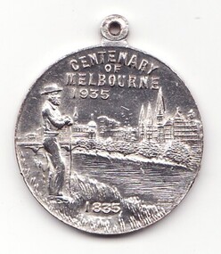 Learmonth and District Historical Society Inc.
Medal - Centenary of Victoria, Centenary of Melbourne 1935
White metal medal issued to commemorate Melbourne's centenary 1934-35. This medal was given out to Victorian school children; 325,600 white metal medals were struck. There were also a few VIP pieces in other metals, including two in gold. The medal references Portland, the location of Victoria's first settlement. The Henty brothers, entrepreneur farmers and whalers, established the state's first permanent European settlement in Portland in 1834. Melbourne was established the following year by a party of settlers led by John Batman. In 1934, as Melbourne planned to celebrate the centenary of European settlement, it seemed to some that there was little to celebrate. The financial strains of the depression, unemployment and the scandal of the city's slums all undercut claims of unbridled progress. Perhaps because of such troubles, the organisers of the centenary celebrations tried doubly hard to be positive. The themes of the celebrations were conservative, reflecting the desire of some Melburnians for security in troubled times. The widely promoted image of the 'Garden City' and 'Queen City of the South' emphasised the idea of Melbourne as a very British city. A visit by the Duke of Gloucester, son of George V, the ageing king, provided a reassuring strengthening of Melbourne's imperial connections. The presented view of Melbourne's history stressed the 'myth of the pioneer', embodied in the person of John Batman. Elevated to heroic status, he was reinvented as a courageous pioneer whose life exemplified the rewards of self-improvement. Such a portrayal ignored Batman's dubious 'treaty' with local Aborigines and the less savoury details of his personal life. Melbourne's indigenous people were excluded from this triumphant view of Melbourne's past. The centenary celebrations now seem dated, but the image of Melbourne as a conservative city largely influenced by Britain has been more enduring.Details the settlement of Portland, Melbourne and Victoria, 1834 - 1935Double sided round white metal medal, featuring on front face, the bay of Portland showing a ship in the harbour. On the reverse side of the medal is John Bateman overlooking the city of Melbourne and the Yarra river.The front is inscribed, "CENTENARY OF VICTORIA" 1934, across the top, bottom right has the words "PORTLAND 1834". Reverse side shows "CENTENARY OF MELBOURNE 1935", and the date 1835 at the bottom. melbourne, medal, portland, centenary of victoria 1935 -
 Eltham District Historical Society Inc
Photograph, Liz Pidgeon, Heritage Excursion; Eltham Lower Park Walk and Talk, 1 July 2017, 1 July 2017
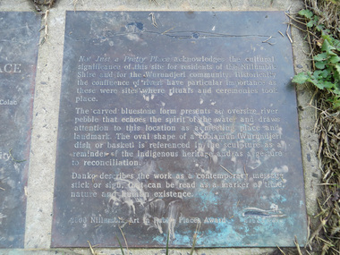
Transcription of plaque: Not Just a Pretty Place acknowledges the cultural significance of this site for residnets of the Nillumbik Shire and for the Wurundjeri community. Historically the confluence of rivers have particular importance as these were sites where rituals and ceremonies took place. The carved bluestone form presents an oversize river pebble that echoes the spirit of the water and draws attention to this location as a meeting place and landmark. The oval shape of a coolamun (Wurundjeri dish or basket) is referenced in the sculpture as a reminder of the indigenous heritage and as a gesture to reconciliation Danko describes the work as a contemporary message stick or sign, that can be read as a merker of time, nature and human existance. 2000 Nillumbik Art in Public Places Award. Heritage Excursion - Saturday 1st July - Eltham Lower Park - Walk and Talk Eltham Lower Park has played an important part in the history of our area since the early days of European settlement when it was used by local residents as an informal racecourse. Prior to that its location at the junction of the Diamond Creek and the Yarra River made it an important meeting place for the Wurundjeri people. The park combines formal elements and sporting facilities with remnant bushland that is of environmental significance. It is home to sporting and horse riding clubs, popular play spaces and the Diamond Valley Miniature Railway, which attracts large numbers of visitors. The park will be the venue for our July excursion which will comprise a walk of about 3.5 km around the park and adjacent areas. Along the way we will discuss the history and natural history of the area. The path along the creek and the river provides a pleasant and scenic walk. This walk on Saturday 1st July is about 3.5 km in length and will take 2 to 2.5 hours. It will start at 2pm at the Main Road car park at the front of the park. (Melway ref 21 H 10). From Newsletter No., 234, June 2017 Born Digitalelection day, heritage excursion, activities, eltham district historical society, eltham lower park, not just a pretty place, public art, plaque -
 Orbost & District Historical Society
display cabinet and tools
This display was put together by the Curlip Committee and used as promotion in the shed during the construction of Curlip 11 A community project, this boat was constructed out of local hardwood timbers utilizing the traditional skills of wooden boat builders and is powered by a steam engine. Paddle Steamer Curlip II is a replica of an historic paddle steamer of the Snowy River, in Far East Gippsland, Victoria. The original Paddle Steamer Curlip was built by Sam Richardson and his sons Mark, Albert and Frank, at their sawmill at Tabbara, a pioneering settlement on the Brodribb River, a tributary of the Snowy River. The keel was laid on 14th October 1889 and PS Curlip was launched in 1890. The name “ Curlip” is derived from the indigenous name for the area where Tabbara is located and includes land to the east of the Snowy and Brodribb Rivers towards Cape Conran. PS Curlip was registered in 1893 and the Passenger Certificate issued on 30th January 1903 to Captain Alan Richardson by the Marine Board of Victoria entitled her to carry 25 passengers and only 10 passengers when engaged in towage service. Two children under 12 years of age to be reckoned as one passenger. PS Curlip towed five barges at a time, traveling upstream as far as Bete Bolong, 20 km upstream of the mouth to collect produce to be transferred to schooners near Marlo. She towed vessels in and out through the Snowy river entrance and was also used for social functions such as Sunday School picnics. She was the main means of transport for imports and exports on the Snowy River for almost 30 years. The Curlip era ended abruptly on Friday 28th February when a flash flood carried her and 2 barges down river and out to sea, where she washed ashore at Marlo and broke up.More than eighty years after the original Paddle Steamer Curlip was wrecked at sea, the Orbost community launched a replica which it hoped would draw tourists to the region. The P.S. Curlip II, is based on drawings of the original Curlip that made its home in the Snowy and Brodribb Rivers of East Gippsland in the 1890s and early 1900s, It took six years of planning and hundreds of hours of volunteer work from the local community.A display cabinet containing tools and sundry items related to the Paddle Steamer Curlip. (More information on individual items in Catalogue 1400-1600)p.s.curlip richardson-samuel boat-building-tools transport -
Federation University Historical Collection
Newspaper, ANZAC Centenary newspaper features, 2015, 25/04/2015
The Centenary of the ANZAC landing of Gallipoli was marked in 2015. .1) Herald Sun Gallipoli 100-year Anniversary - The Legend Begins. Includes information on Gallipoli, Gallipoli landing, Lemnos, VC Winners, William Dunstan, Bigali, The Nek, Indigenous soldiers, Lone Pine, Gallipoli Retreat Images include: Gallipoli, William Birdwood, Harold Walker, Winston Churchill, Ian Hamilton, John Fisher, William Throsby Bridges Otto Linden von Sanders, Herbert Asquith, Sinclair MacLagan, Mehit Sefik, Mastafa Kermal, nurses on Lemnos, Alexander Burton, Bigali, Turkey, Keith Murdoch, Charles Bean, Joe Stratford, Frank Loud, Thomas Ford, Leslie Boyce, Raymond Brownell, Alfred Lovett, Leonard Lovett, Frederick Amos Lovett, Herbert Stahle Lovett, Cyril Brudenell White, Minyip .2) ANZAC Day 2015 Supplement from The Age. The supplement includes information on Australia's compulsory cadet training, Wireless telegraphists, horses .3) The Age ANZAC centernary Galipoli Tribute, 2015. Eight page broad sheet with amazing stories from the front line. Includes a listing of all those who lost their lives on the Gallipoli Peninsula, timeline of the Gallipoli landing, information on Douglas Barrett-Lennard, William Throsby Bridges, Alan Dudley Henderson, James Charles Martin, Arthur Harold Jopp, John Simpson Kirkpatrick, Cecil Anthony McAnulty, Laurence W. Street, Alfred Shout, Joseph Stratford, Alexander Stewart Burton, Alfred Hearpsgallipoli, anzac centenary, gallipoli landing, walker's ridge, pope's hill, quinn's post, lone pine, pine ridge, shrapnel gully, the sphinx, maclaurin's hill, monash valley, plugge's plateau, dardenells, keith murdoch, charles bean, cadets, compulsory cadet training