Showing 561 items
matching land sales.
-
 City of Moorabbin Historical Society (Operating the Box Cottage Museum)
Flyer - McKinnon Road Estate, McKinnon, 1924
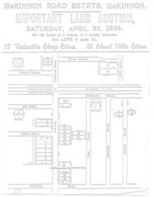
The train line from the city to Frankston was electrified in 1922 which intensified the sale in the municipality of Moorabbin, particularly land which was in the vicinity of the railway stations.Example of the progress of the Municipality of MoorabbinAdvertising flyer for auction of real estate sales - plan of building blocks for saleMcKinnon Road Estate, McKinnon Auction 26 April 1924 - 17 shop sites & 21 villa sitesgraham ave, prince edward ave, station street, mckinnon road, mckinnon, real estate, auctions -
 City of Moorabbin Historical Society (Operating the Box Cottage Museum)
Flyer - North Road Estate, Ormond
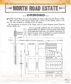
At the end of World War One, there was a renewed interest in residential land and a number of estates opened up in the Municipality of Moorabbin.Example of the progress of the Municipality of MoorabbinAdvertising flyer for auction of real estate sales - plan of building blocks for saleNorth Road Estate, Ormond - plan of subdivision.36north road, wicklow st, leinster st, ormond, real estate -
 City of Moorabbin Historical Society (Operating the Box Cottage Museum)
Flyer - O'Donovan's Estate, Highett
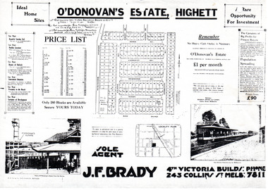
At the end of World War One, there was a renewed interest in residential land and a number of estates opened up in the Municipality of Moorabbin.Example of the progress of the Municipality of MoorabbinAdvertising flyer for auction of real estate sales - plan of building blocks for saleO'Donovan's Estate Highett - 180 blocksjames ave, clonmult ave, desmond av, mary av, bay road, cloyne street, middleton st, real estate, highett -
 City of Moorabbin Historical Society (Operating the Box Cottage Museum)
Flyer - Ormond Park Estate, Ormond, 1923
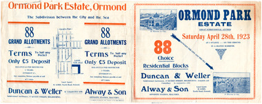
The train line from the city to Frankston was electrified in 1922 which intensified the sale in the municipality of Moorabbin, particularly land which was in the vicinity of the railway stations.Example of the progress of the Municipality of MoorabbinAdvertising flyer for auction of real estate sales - plan of building blocks for saleOrmond Park Estate, Ormond Auction Saturday 28 April 1923 - 88 residential blocks54jasper road, manchester road (now mckinnon road), hill street (now hall sreet), jasper street (now lewis street), real estate, auction, mckinnon, ormond -
 City of Moorabbin Historical Society (Operating the Box Cottage Museum)
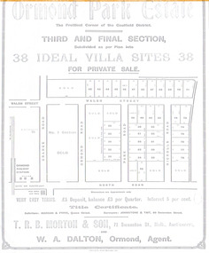
Flyer - Ormond Parke Estate, Ormond, 1913
At the end of World War One, there was a renewed interest in residential land and a number of estates opened up in the Municipality of Moorabbin.Example of the progress of the Municipality of MoorabbinPhotocopy of advertising flyer for private sale of real estate sales - plan of building blocks for saleOrmond Parke Estate, Ormond - Third and final section for private salewalsh st, ormond road, park road, nicholls road, ormond, real estate -
 City of Moorabbin Historical Society (Operating the Box Cottage Museum)
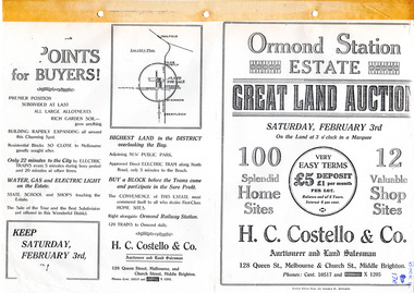
Flyer - Ormond Station Estate, Ormond, 1923
At the end of World War One, there was a renewed interest in residential land and a number of estates opened up in the Municipality of Moorabbin.Example of the progress of the Municipality of MoorabbinAdvertising flyer for auction of real estate sales - plan of building blocks for saleOrmond Station Estate, Ormond - Great Land Auction - 100 Home sites 12 shop sites - Auction Saturday 3rd February 1923malane st, foch st, coane st, beatty crescent, ormond, real estate, auction -
 City of Moorabbin Historical Society (Operating the Box Cottage Museum)
Flyer - Ozone Hill Estate, Cheltenham, 1923
The train line from the city to Frankston was electrified in 1922 which intensified the sale in the municipality of Moorabbin, particularly land which was in the vicinity of the railway stations.Example of the progress of the Municipality of MoorabbinPhotocopy of Advertising flyer for sale of real estate sales - plan of building blocks for saleOzone Hill Estate, Cheltenham 41 choice residential allotments.victor avenue, weatherall road, cheltenham, real estate, auction -
 City of Moorabbin Historical Society (Operating the Box Cottage Museum)
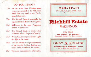
Flyer - Ritchill Estate, McKinnon, 1927
The train line from the city to Frankston was electrified in 1922 which intensified the sale in the municipality of Moorabbin, particularly land which was in the vicinity of the railway stations.Example of the progress of the Municipality of MoorabbinAdvertising flyer for auction of real estate sales - plan of building blocks for saleRitchill Estate, McKinnon, auction Saturday 5 April 1930lysbeth street, amelia st, murray road, mckinnon, auction, real estate, moorabbin -
 City of Moorabbin Historical Society (Operating the Box Cottage Museum)
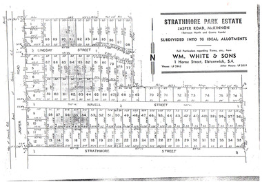
Flyer - Strathmore Park Estate, Jasper Road McKinnon, 1942
After WWII there was a decline in the market gardens in the City of Moorabbin, as the value of the land was more profitable than the crops.Example of the progress of the Municipality of MoorabbinPhotocopy of advertising flyer for auction of real estate sales - plan of building blocks for saleStrathmore Park Estate, Jasper Road Bentleigh Subdivided into 98 Ideal Allotmentsstrathmore street, wavell street, lindsay street, jasper road, mckinnon, bentleigh, real estate, auction -
 City of Moorabbin Historical Society (Operating the Box Cottage Museum)
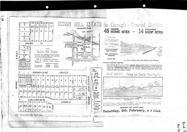
Flyer - Sunny Hill Estate, Carnegie, 1924
The train line from the city to Frankston was electrified in 1922 which intensified the sale in the municipality of Moorabbin, particularly land which was in the vicinity of the railway stations.Example of the progress of the Municipality of MoorabbinAdvertising flyer for auction of real estate sales - plan of building blocks for saleSunny Hill Estate in Carnegie - Ormond District Auction 46 Home sites - 14 Shop sites Auction 9 February 1924rigby ave, leila rd, koornanag road, grandview grove, oakleigh road, mckinnon, ormond, carnegie -
 City of Moorabbin Historical Society (Operating the Box Cottage Museum)
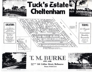
Flyer - Tuck's Estate, Cheltenham, 1940
After WWII there was a decline in the market gardens in the City of Moorabbin, as the value of the land was more profitable than the crops.Example of the progress of the Municipality of MoorabbinPhotocopy of advertising flyer for sale of real estate sales - plan of building blocks for saleTuck's Estate Cheltenham - plan of subdivisionedward street, point nepean road, eden street, tuck street, hoffman street, elman road, page street, cheltenham, real estates, auction, tuck -
 Bendigo Historical Society Inc.
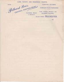
Document - PETHARD COLLECTION: LETTERHEAD - PETHARD BROTHERS, LAND , ESTATE AND INSURANCE AGENTS , ROCHESTER
LETTERHEAD - PETHARD BROTHERS, LAND , ESTATE AND INSURANCE AGENTS , ROCHESTER Five pages of letterhead writing paper. The letterhead is printed in Blue Ink and contains the following words 'Phone', 'Pethard Bros', Central Auction Mart, 'Land Estate and Insurance Agents, 'Furniture Salesmen', 'Complete House Furnishes',' Clearing sales a speciality', 'farm, garden, 'Produce and Machinery Salesmen', 'Gillies Street, Rochester'.Pethard Bros. Central Auction Mart, Rochester.cottage, miners -
 Bendigo Historical Society Inc.
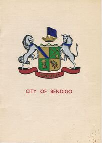
Book - JOAN O'SHEA COLLECTION: 150TH ANNIVERSARY OF BENDIGO BOOKLET, 1850 - 1950's
Joan O'Shea Collection. Buff Coloured Booklet City of Bendigo. 150th anniversary of Bendigo 1850s to 1950s. Image on cover coat of arms for City of Bendigo underneath word progress, left hand side horse, right hand side bullock. History of Bendigo: From Sheep Run to Provincial City in 100 years. Map of Bendigo and Surrounds Railways, Water Courses & Storage, Power, Municipal Boundaries & Land Available for Industry. Municipal District Creation 1855, Borough Proclamation 1863, Proclaimed City 1871, Area: 7992 Acres Population as of last census City of Bendigo 28,722, City of Bendigo and adjacent Urban Areas 36,909. City of Bendigo Map, The Past Prior to 1850. Icons of Bendigo The Bendigo base Hospital,Law Courts & Post Office, Primary Schools, Housing, Industry including Butter Production, Poultry Farming, Livestock Sales & Tomato Growing, Slaughter House & ordnance factory. The Present Recreation Photos: Bendigo Bowling Club, Queen Elizabeth Oval, Municipal Lawn Tennis Courts The Future of Bendigo, Bendigo Photographs From The 1950s,Cambridge Press Bendigobendigo, history, progress of bendigo 1850s on. -
 Chelsea & District Historical Society Inc
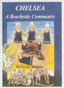
Book, Frank McGuire, Chelsea a Beachside Community, 1985
... McGuire B.E.M. History of Chelsea, first land sales in 1875 ...Chelsea: a Beachside Community, is the result of much research by the honorary historian of the City of Chelsea Historical Society Inc, Frank McGuire B.E.M.History of Chelsea, first land sales in 1875, highlights of Chelsea history up to 1985.Book soft cover life savers in costume with a lifesaving reel chelsea & district historical society inc., early settlers -
 Sunshine and District Historical Society Incorporated
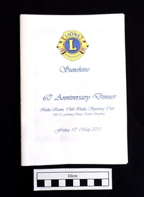
Booklet (2013), LIONS CLUB of SUNSHINE 60th Anniversary Dinner, 10 May 2013, 2013
On 12th May 1953 a meeting was arranged by the Lions Club of Footscray, and was held at the home of Bill Harvey in Sunshine, with the intention of forming a club in the Sunshine area. The first official luncheon was held on 3rd June 1953 at the Sunshine Town Hall and was attended by representatives from Melbourne, Footscray and Essendon Clubs. After the membership reached 25 the Lions Club of Sunshine was Chartered on 21st July 1953, and became the 5th Club in Victoria and the 17th in Australia. Over the years the club raised funds through various activities to provide charitable donations to organisations, people, and disaster areas, as well as to purchase house and land for a Senior Citizens Club. It became necessary to sell the house and land years later. The Lions Club also contributed to the Sunshine Swimming Pool which was opened in December 1960, and was welcomed by the children of Sunshine. Some of the activities to raise funds included Guy Fawkes bonfire nights, rodeos, paper and bottle drives, jumble sales,Tivoli Gala Nights, car raffles, and sausage sizzles. Over the past 10 years the Sunshine Lions have put in thousands of hours of work, and have disbursed in excess of $200,000 for charitable purposes. As well as supporting overseas projects and natural disasters, the Lions have continued their community work. Funds have been donated to care providers such as the Mercy Hospice and Scope, and also used to provide Christmas hampers and dinners, and for underprivileged children to have holidays. Some of the organisations that have recently received funds were Helping Hands Across the Pacific, Gellibrand Services, Royal District Nursing Service, and the Sunshine Mission. During 1960/61 the club membership reached a record 58, however at the time of the 60th Anniversary dinner the membership was 17, three of which were in their seventies and 3 in their eighties. The above brief historical information was sourced from the 60th Anniversary Dinner booklet.This booklet is significant because it contains an 11 page summarised historical record of the 60 years of activities of the Lions Club of Sunshine. It also contains an Honour Roll of past members and of members who received awards, as well as the names of the 61 people who served as Club Presidents from W.T. Harvey (1953-54) to P. Green (2012-13). The booklet can be used as a starting reference source for anybody seeking information about the Lions Club of Sunshine Inc.White paper booklet of 20 pages with blue printing and a blue and yellow Lions International emblem on the front cover. The booklet contains the dinner Menu and the Programme for the evening, as well as a summary of the 60 years of activities of the LIONS CLUB of SUNSHINE. It also features the names of the 61 Club Presidents, the members who received awards, and an Honour Roll.LIONS L INTERNATIONAL / Sunshine / 60th Anniversary Dinner / Italia Room, Club Italia Sporting Club 128-152 Furlong Road, North Sunshine / Friday 10th May 2013lions club of sunshine, 60th anniversary dinner, lions sunshine presidents 1953-2013, lions sunshine honour roll, historical activities of lions sunshine -
 National Wool Museum
Photo Album, 1930-1934
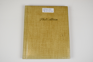
The Photo Album was created by Hans Beck, who interned with the donor's father (Wilhelm Eckels). The Photo Album depicts wool buying and sheep station related life between 1927-1939. Each photograph has been individually labelled.Straw coloured booklet with gold cursive writing on front cover spelling 'Photo Album'. Inside are 18 pages containing 63 photographs, each individually captioned. Internal pages show signs of age with discolouration, particularly in areas of previous adhesive application.Lettering, Front: Historic Interest Before WME arrived - 1930-1934 Wool & Sheep Photo Album Lettering, Internal by Page: Page 1 - Bottom Left Conner: Table from right:/ O. Hilbert sen. / WW. Richter, W. Ehrig/ Sampler: C. McCarthy/ at desk: E.S. Bottom Right Corner: 1927/ Wool Sample Room/ O. Hilbert/ Terranora Buildings/ Reiby Lane Page 2 - Bottom Middle: 1931/ Opening Sale/ Sydney Page 3 - Bottom Middle: 1934/ Opening Sale/ Sydney Page 4 - Bottom Middle: 1933/ Wool Auctions/ Brisbane Page 5 - Top Left Corner: 1930 Escapade/ Sydney to CAIRNS/ via Bourke, Central/ Queensland, Hinter-/ land & Atherton/ Table Lands Top Right Corner: Dubbo: Main Street/ (1st Night)/ 31.7.1930 Middle Right: 1st Night-"OUT"/ Stranded 11 miles/ from Bourke. (Red/ Dust in Carburettor Bottom Right Corner: Our "ERSKINE'/ hits Culvert &/ breaks both King-/pins. 1 1/2 miles from/ CUNNAMULLA SW-Q. Page 6 - Top Right Corner: "Rosevale Station"/ via Cunnamulla SWQ/ "Gidgi" country/ Gidgi Creak &/ Warrigo R. Middle Left: STAN HILL Page 7 - Middle Top: Blackhall/ Tattersall's Hotel/ Yarning at Cross-/roads. Middle Left: FO Wool Sales/ 22 Horse team Middle Right: Roadsign to:/ ISIS DOWNS &/ Homestead (Fart Page 8 - Middle Top: Muster: 3000 sheep/ Semi-circular/ Shearing shed/ ISIS DOWNS Page 9 - Middle Top: Shearer/ Water Tower/ Counting out/ pens Middle Bottom: Shearers Cook/ Hot Water & Soup/ Cake for Shearing/ Shed Charity Ball Page 10 - Middle Left: Isis Downs Home-/ stead with fire// flood Lookout./ Artesian Borewell Bottom Right: Manager: Moore/ & Alfred Loh-/ mann with kills/ Ducks & Emus Page 11 - Top Middle: PORTLAND DOWNS/ Muster: 10,000/ Sheep Bottom Left: Manager:/ Mr. Luck/ with A.L./Moore Page 12 - Middle Top: ROOKWOOD Station/ near/ HUGHENDEN/ Central NWQ Page 13 - Top Middle: 'HINTERLAND"/ Cattle country/ Spear Grass/ Tracks Bottom Middle: Crossings:/ Creeks: Quick/ Sand/ Rivers: rocky Page 14 - Middle Right: Lyndhurst stat/tion/ Head Stockman Middle Left: -Valley of la-/goons/ Station Bottom Right Corner: Master Atkinson/ saves/ Petrol shortage Page 15 - Top Middle: ATHERTON TABLELANDS/ LAKE BERRINE Middle Centre: Tropical Rainforest/ near/ Lake Berrine Page 16 - Top Middle: ATHERTON TABLELANDS/ Timber Country Bottom Middle Edge: CAIRNS/ Imperial Hotel Page 17 - Hans Beck with/ Betty Hilbert/ Lapstone Hill 1931 wool - transportation, wool sales, wool growing, wool growing agriculture farming, wool industry, wool sales - sydney, wool sales - brisbane, dubbo, 1930, bourke, cunnamulla, isis downs, shearing, shearing - lifestyle, portland downs, muster, hughenden, hinterland, lake berrine, cairns -
 National Wool Museum
Book, Wool: a case for optimism
"Wool - A Case For Optimism" by Jack H. Allerding, December 1967.wool marketing wool sales wool brokering wool - measurement woolclassing - objective measurement, australian mercantile land and finance company ltd, wool marketing, wool sales, wool brokering, wool - measurement, woolclassing - objective measurement -
National Wool Museum
Booklet, Waybills
... Wool - transportation Wool Sales Messrs J H Landers & Co ...Wool waybills booklet produced by Winchcombe, Carson Ltd. Booklet found intact among other papers in an old box on a farm on the central coast of NSW in the early 1990s and many hundreds of km from Gulargambone (Barry Blair).Messrs J H Landers & Co, Lanauria, Gulargambonewool - transportation wool sales, winchcombe, carson limited, lanauria, gulargambone, wool - transportation, wool sales -
Koorie Heritage Trust
Book, Bonwick, James, Discovery and Settlement of Port Phillip; being a history of the country now called Victoria, up to the arrival of Mr. Superintendent Latrobe, in October, 1839 by James Bonwick; revised, at request, by W. Westgarth, 1856
... ; Stewart, Simpson, Lonsdale, Latrobe; The Land and Land Sales; Law ...Contents: Discovery of Port Phillip; First Settlement of Port Phillip; Abandonment of the Colony of Port Phillip; Further discoveries in the Country; Hume and Hovell's Overland Trip; Settlement of Western Port; Captain Sturt on the Murray; Major Mitchell's Australia Felix; The Successful Settlement of Port Phillip; Batman and Gellibrand's Application; Settlement of Portland Bay; Life of Batman; Batman's visit to Port Phillip; Fawkner's Yarra Settlement; Mr. Wedge's Narrative; William Buckley; The Association and Government; Progress of the Settlement; Flocks and Flock-masters; Government; Stewart, Simpson, Lonsdale, Latrobe; The Land and Land Sales; Law, Police and Port; Commerce, Trade and Shipping; Melbourne and Geelong; Hotels and Licences; Amusements; Rise and Progress of the Port Phillip Press; Religion in Port Phillip.142 p. : 1 fold-out map. ; 21 cm.Contents: Discovery of Port Phillip; First Settlement of Port Phillip; Abandonment of the Colony of Port Phillip; Further discoveries in the Country; Hume and Hovell's Overland Trip; Settlement of Western Port; Captain Sturt on the Murray; Major Mitchell's Australia Felix; The Successful Settlement of Port Phillip; Batman and Gellibrand's Application; Settlement of Portland Bay; Life of Batman; Batman's visit to Port Phillip; Fawkner's Yarra Settlement; Mr. Wedge's Narrative; William Buckley; The Association and Government; Progress of the Settlement; Flocks and Flock-masters; Government; Stewart, Simpson, Lonsdale, Latrobe; The Land and Land Sales; Law, Police and Port; Commerce, Trade and Shipping; Melbourne and Geelong; Hotels and Licences; Amusements; Rise and Progress of the Port Phillip Press; Religion in Port Phillip.victoria -- history -- to 1834. | victoria -- history -- 1834-1851. | melbourne (vic.) -- history -- to 1834. | melbourne (vic.) -- history -- 1834-1851. -
 National Wool Museum
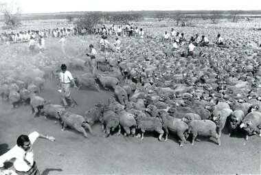
Photograph
Photo depicts the combined Elders, Dennys sheep sale held at Jerilderie on 5 Oct. 1973, where 60,000 sheep were sold, which constituted the largest wool sale at that time. The photographer was Frank Johnstone, now retired, of the newspaper 'Stock and Land' who covered the sale. Those identified in the photos are: Ray Hobson in mid-foreground behind in pen, Harry Gibbs (back to hat), Ken McKenzie (hat), Clive Hoelter (book), Danny Reilly (behind leaning on fence), right - Bob Falconer (white hat).Sheep sale at Jerilderie, 5 Oct. 1973.Jerilderie Sheep Sale 5th October 1973 / 60,000,00 sheep. Largest sheep sale in Australia COMBINED ELDERS, DENNYS SALE / Ray Hobson in mid- / foreground / behind, in pen, / Harry Gibbs (back & o,hat) / Ken McKenzie (hat) / Clive Hoelter (book) / behind leaning on fence / Danny Reilly / right Bob Falconer (white hat)sheep sales, dennys, lascelles limited elders vp -
Whitehorse Historical Society Inc.
Document, Land Subdivision, cnr Springvale and Burwood Roads, n.d
Hand drawn document of land subdivision,Hand drawn document of land subdivision, Springvale Road & Burwood Road, together with notes of various sales from 1857 to 1957.Hand drawn document of land subdivision, burwood road, vermont south, springvale road, vermont south, stanley road, vermont south, vermont south, mayne, alexander, mayne, james alexander, craig, silas gordon, fankhauser, frederick william, fankhauser, mervyn william, burrell, charles, donaldson, john -
 Melbourne Legacy
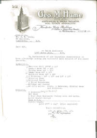
Letter, re Brick Residence 1267 Burke Road, Kew, 1942
Detailed measurements of the rooms, but the plan of the land noted as being enclosed is not included. The details had been requested in a previous telephone conversation between the parties, indicating early interest in purchasing the property which ultimately became Holmbush. Despite being from a real estate agent there is little in the way of a sales pitch.As well as indicating the extent of the rooms, it also notes that the property had a coke hot water system, which would have been typical of the 1940s, as would the elaborate letterhead.Typewritten undated letter on letterhead of Geo.M.Hume Pty Ltd., black on white, addressed to Mr. D.N. CraigSignature illegible.holmbush initial negotiations, properties, holmbush -
 Ballarat Tramway Museum
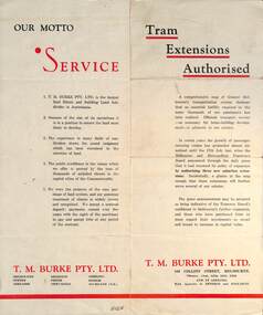
Pamphlet - Real Estate, T M Burke Pty Ltd, "Tram Extensions Authorised", 1936
Wal Jack collected tramway and railway items for his collection. This pamphlet gives details of the Melbourne Public Transport system - rail, tram and bus in late 1936. Issued by T M Burke Pty Ltd of 840 Collins St Melbourne, Real Estate agents, shows the extensive sub-divisions where land was available for purchase and notes the MMTB authorisation of new tram routes. Gives details of the T M Burke services. Routes shown as authorised (16-7-1936) are: Keilor Road Essendon, High St North Balwyn and Hawthorn Road East Brighton. Demonstrates a Real Estate Sales pamphlet.Pamphlet - four colours printed on cream coloured bond paper, folded vertically originally.letter, wal jack, buninyong, railway lines -
 Kew Historical Society Inc
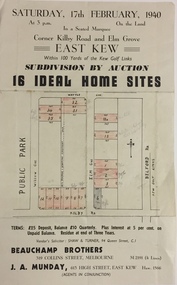
Plan - Subdivision Plan, Subdivision by Auction: 16 Ideal Home Sites, East Kew, 1940, 1940
... in the second year of the war indicates that land sales for homes ...An advertisement for the sale of a subdivision by Auction: of 16 Ideal Home Sites, East Kew, 1940. This significant sale of land between the Kew Golf Course and Willsmere Park led to the streets having a high degree of architectural uniformity.The subdivision in the second year of the war indicates that land sales for homes and speculation continued from the 1930s into the period of the Second World War. There is no indication on the plan that a war is occurring.Single page subdivision plan advertising the sale by Auction of 16 Ideal Home Sites, in East Kew, on 17 February 1940. Streets named in the plan include: Kilby Road, Belford Road, Elm Grove, Willow Grove. Willsmere Park is indicated but not named. The auction was conducted by Beauchamp Brothers. A number of lots are coloured pink on the plan indicating those lots for sale and/or those already sold.subdivision plans - kew east (vic) -
 Kew Historical Society Inc
Plan - Subdivision Plan, Normanby Heights Estate, Kew, 1919
Prue Sanderson, in her groundbreaking ‘City of Kew Urban Conservation Study : Volume 2 - Development History’ (1988), summarised the periods of urban development and subdivisions of land in Kew. The periods that she identified included 1845-1880, 1880-1893, 1893-1921, 1921-1933, 1933-1943, and Post-War Development. These periods were selected as they represented periods of rapid growth or decline in urban development. An obvious starting point for Sanderson’s groupings involved population growth and the associated economic cycles. These cycles also highlighted urban expansion onto land that was predominantly rural, although in other cases it represented the decline and breakup of large estates. A number of the plans in the Kew Historical Society’s collection can also be found in other collections, such as those of the State Library of Victoria and the Boroondara Library Service. A number are however unique to the collection.The Kew Historical Society collection includes almost 100 subdivision plans pertaining to suburbs of the City of Melbourne. Most of these are of Kew, Kew East or Studley Park, although a smaller number are plans of Camberwell, Deepdene, Balwyn and Hawthorn. It is believed that the majority of the plans were gifted to the Society by persons connected with the real estate firm - J. R. Mathers and McMillan, 136 Cotham Road, Kew. The Plans in the collection are rarely in pristine form, being working plans on which the agent would write notes and record lots sold and the prices of these. The subdivision plans are historically significant examples of the growth of urban Melbourne from the beginning of the 20th Century up until the 1980s. A number of the plans are double-sided and often include a photograph on the reverse. A number of the latter are by noted photographers such as J.E. Barnes.The Normanby Heights Estate not unusually used hyperbole to attract purchasers to the auction of 17 lots facing Argyle Street (sic), Pleasant Avenue and Normanby Road. Predictably factors appealed to included the proximity to schools etc, the availability of public utilities, friable soil, picturesque views and ‘advancing settlement’. If that were not enough, the sales pitch exhorted prospective purchasers to consider their backbone. ‘Thrift is unquestionably the Backbone of any Nation. No better form of Thrift can be encouraged in the young citizen than by investing his or her savings in a piece of land in a growing, healthy and beautiful locality. NORMANBY HEIGHTS ESTATE admirably fits the need.’ The experience of Australia at war undoubtedly contributed to the use of terms such as ‘Backbone of a Nation’ and the appeal to egalitarian principles in the choice of the term ‘young citizen’. The recognition that women had savings and might be the prospective purchaser also reflects a new sense of the rights and entitlements of women in the postwar period.subdivision plans - kew, normanby heights estate, pleasant avenue, normanby road, argyle street -
 Kew Historical Society Inc
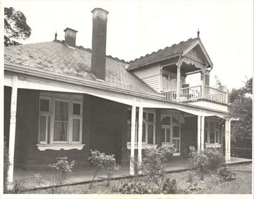
Photograph, Willsmere, circa 1965, c. 1965
The historian Dorothy Rogers records (A History of Kew, p.5) that "In 1888 he [Arthur Wills] took over his estate, 'Willsmere', and conducted it as a dairy farm. He was an architect by profession, and having established the farm he rented it, and returned to live in Barry Street, Kew, where his only child, Dorothy was born in 1889. He entered Kew Council in 1891, and three years later built a new house in Fellows Street, on land that Thomas had purchased at the 1846-47 sales. He became Mayor of Kew in 1896-97, and during his term of office sold this house and built the present 'Willsmere' [pictured] on the corner of Willsmere and Belford Roads. ... Never a house of great distinction, it has now been demolished to make way for a freeway."This work forms part of the collection assembled by the historian Dorothy Rogers, that was donated to the Kew Historical Society by her son John Rogers in 2015. The manuscripts, photographs, maps, and documents were sourced by her from both family and local collections or produced as references for her print publications. Many were directly used by Rogers in writing ‘Lovely Old Homes of Kew’ (1961) and 'A History of Kew' (1973), or the numerous articles on local history that she produced for suburban newspapers. Most of the photographs in the collection include detailed annotations in her hand. The Rogers Collection provides a comprehensive insight into the working habits of a historian in the 1960s and 1970s. Together it forms the largest privately-donated collection within the archives of the Kew Historical Society.Willsmere, the home of the Wills family of Kew, designed by the architect Arthur Wills, circa 1896. arthur wills, willsmere, belford road, willsmere road, dorothy rogers, kew, wills family -
 Surrey Hills Historical Society Collection
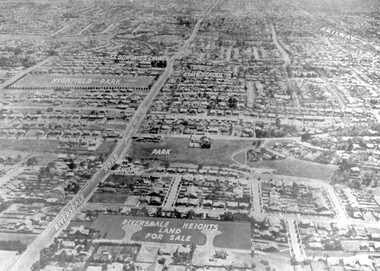
Photograph - Aerial view Riversdale Heights Estate area, c1923
This was probably part of a real estate promotion for the sale of the Riversdale Heights Estate. This was subdivided by Messrs. Duncan and Weller. Of the allotments offered, 30 were sold and realised £4600. Date of this sale was c December 1923. This suggests that the date This are was one of the last pieces of former rural land to be sub-divided for housing in Surrey Hills.The land between it and South Surrey Park was sub-divided post WW1, hence the naming of the streets after sites of WW1 battles.A black and white reproduction of an aerial photo of the area near the corner of Warragul and Riversdale Roads looking west towards the city. Some features have been identified by name including the Riversdale Heights Estate, which was being sub-divided. North and South Courts are shown. Other roads (unmarked) in the foreground are Graham Street, Allie Street, Thistle Street, Lille Street, Amiens Street, and Marne Street. Beyond these is the area marked 'PARK' (South Surrey Park), which is devoid of vegetation. Areas of Camberwell and Canterbury are also shown. The area covered extends to beyond St Dominic's Church. The original is mounted on a cream deckle-edged paper.Beneath the original on the mount: "SOUTH SURREY HILLS LOOKING WEST c. 1936" [The reference to the sale in the Box Hill Reporter of December 1923 found on Trove suggests that this date is not accurate.] Rear top LH corner of original in Jocelyn Hall's handwriting: "For Centre / from Mr James Long"riversdale heights estate, riversdale road, allie street, south surrey park, lille street, thistle street, amiens street, marne street, south court, north court, duncan and weller, real estate sales, graham street, st dominics church, highfield park, canterbury primary school, aerial photo -
 Bacchus Marsh & District Historical Society
Map, Bacchus Marsh Township and Nearby Districts Maps Volume
... including landholders, land sales, infrastructure, such as roads ...This volume of maps is believed to have been compiled by staff at the Shire of Bacchus Marsh and was presumably used to inform and assist Shire staff and Councillors in the carriage of their duties.This collection of maps are significant due to their rarity as many of them are unique maps made for local purposes in the Bacchus Marsh region. They are also of strong research value containing a wide variety of information including landholders, land sales, infrastructure, such as roads, bridges, public, commercial and private buildings, houses, land use, and geographic features over multiple decades from the late nineteen century into the middle part of the twentieth century.One bound volume of maps comprising cadastral maps, (indicating property owners and land boundaries), land plans and real estate auction plans and advertising material, and other maps indicating major infrastructure like proposed roads and irrigation areas. Most of the maps and plans are of Bacchus Marsh and nearby areas but some maps are of nearby towns such as Melton, Ballan and Blackwood. The volume comprises 52 pages. Most pages have a single map or plan pasted onto it but some contain 2 or 3 different maps. There are 81 maps in total. Map 1 Liquidators Sale 1896. Map 2. Woodside Estate Sale 1913. maps, maps bacchus marsh, maps bacchus marsh region -
 Wodonga & District Historical Society Inc
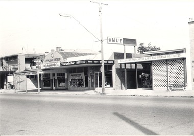
Photograph - Mann Collection Album - Terminus Hotel; Gippsland & Northern
This photo is part of a collection of Wodonga Town Photos donated by Elaine Mann. Elaine was married to David Mann, a successful Wodonga businessman and community leader who passed away in Wodonga in June 2012. David was a member of the Mann family who began their business in Wodonga in 1920. Elaine was a teacher in Wodonga for many years and an active member of the community. The Terminus Hotel In 1873, James Thompson Hatch built the two-storeyed Terminus Hotel at 79 Sydney Road (later known as High Street), then sold it to George Day and Kenneth McLennan for £1,230. It was first licensed to J. G. Morton in January 1874. In 1879, Annie Allen, from Ireland, took over as licensee of the hotel containing 14 rooms, after she and her husband, George James Allen, purchased it. He became licensee in 1883. Under the Allens, the Terminus became, ‘a principal rendezvous for visitors to the town.’ September 1888 saw additions to the building that included a billiard room, a dining room, and 18 other rooms. Following the death of her husband in 1889, Annie Allen continued to run the Terminus Hotel. She later married John Haldon and was licensee of the hotel until 1893 when the licence was transferred to William Carkeek. In the early 1900s the Hotel was thoroughly renovated. The Terminus Hotel was for sale by auction on 5th March 1909. It comprised about 50 rooms, a two-storey building built of brick and iron with hot and cold water service and acetylene gas throughout. The principal hotel in Wodonga, was let from 1st January 1909 on a seven years’ lease at a rental of £9 per week. 1935 saw extensive improvements by proprietor W. P. Kinney, while in 1941 further extensive improvements were carried out to make a good hotel better. A pall of shock and disbelief descended over Wodonga’s historic Terminus Hotel on 1st June 1998 when it was destroyed by fire then demolished in 1999. The site was sold for almost $1 million and redeveloped for a medical clinic.This photo collection is of significance as it documents how the businesses and buildings in Wodonga have evolved and contributed to community throughout the late 20th century.Terminus Hotel; Gippsland & Northern Co-operative Pty. Ltd.; Graham Bradbury Men's Hairdresser; Patricia Anne Fashions; Australian Mercantile Land and Finance Company (A.M.L. & F). on the west side of High Street. The Terminus Hotel was built C. 1873. and was destroyed by fire in 1998, The Gippsland and Northern Co-operative Co. Ltd was formed in 1905, but the date of its establishment in Wodonga is not confirmed, but they were holding fortnightly sales at the Wodonga sale yards by early 1919.wodonga businesses, high st wodonga, terminus hotel, gippsland & northern -
 Whitehorse Historical Society Inc.
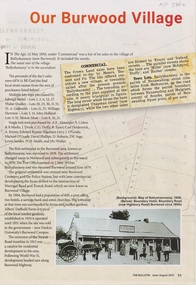
Article - The Bulletin newsletter, The Bulletin Jun - Aug 2022, Our Burwood Village, June 2022
An article about the first settlement surveyed in 1858 in the Burwood area known as Ballyshanassy. It later became Norwood and finally Burwood in 1879.An article about the first settlement surveyed in 1858 in the Burwood area known as Ballyshanassy. It later became Norwood and finally Burwood in 1879.An article about the first settlement surveyed in 1858 in the Burwood area known as Ballyshanassy. It later became Norwood and finally Burwood in 1879.ballyshanassy, albers ernest, boundary road burwood east, dempsey