Showing 532 items
matching mining areas
-
 Bendigo Historical Society Inc.
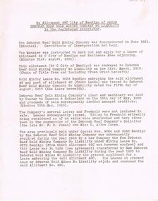
Document - MCCOLL, RANKIN AND STANISTREET COLLECTION: DEBORAH REEF GOLD MINING COMPANY HISTORY OF LEASE, June 1911
2 copies of document, 1original, 1 copy. Information re lease of allotment 49C City of Bendigo and the residence area adjoining. Mentioned in document: sale of Deborah Reef Gold Mining Company's plant and machinery sold by tender to Cameron and Sutherland on the 18th day of May, 1920. Deborah Reef Company's solicitor was the late Mr. F.D. Jones and Miss G. Alice Jones.business, mining, mccoll rankin & stanistreet collection:, mining, allotment 49c, deborah reef gold mining company. -
 Bendigo Historical Society Inc.
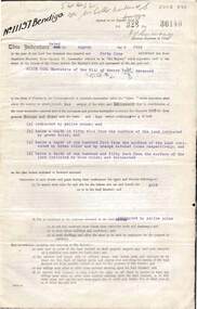
Document - MCCOLL, RANKIN AND STANISTREET COLLECTION: INDENTURE GOLD MINING LEASE CROWN LAND 11197 ALICE PEEL, 8th July 1945
6 page indenture document plus plan, between King George VI and Alice Peel Executrix of the Will of Edward Peel, deceased., dated 8th July, 1945. Lease number 11197, total area of 11 acres, 3 roods, 15 perches. Leases shown on plan: 1197, 1198, 11062, 10690, 11141, 11075. Cemetery reserve shown. Streets: Gladstone Street, Adam Street, Houston Street, Fletcher Street, Honeybone Street, Key on plan shows depths correlated to colours. On back of document history of ownership of lease shown - Deborah Gold Mines No Liability, dated 1946, and 1950.bendigo, mining, lease 11197 bendigo. edward peel, alice peel, edward pell, gladson, adam, huston fletcher and honeybone streets. -
 Bendigo Historical Society Inc.
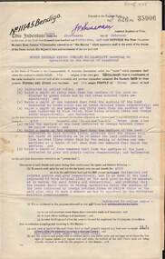
Document - MCCOLL, RANKIN AND STANISTREET COLLECTION: INDENTURE GOLD MINING LEASE NO. 11145 CROWN AND NORTH DEBORAH MINING COMPANY, 14th February, 1941
6 page document plus map : Gold mining lease No. 11145 between Crown ( King George VI) and North Deborah Mining Company, Parish of Sandhurst, dated 14th February, 1941. Map: Lease No. 11145 'Mining District of Bendigo, County of Bendigo, Parish of Sandhurst. Total area 48 acres, 3 roods, 22 perches. Map has extensive colour key indicating depths below surface that will be mined. Crown land and surface excised shown in orange cross-hatching. Lease holdings on map: 10753, 11020, 1363 T.L., 1115 T.L., 11013, 11062, 11033, 9988. Dam shown on 11013. Railway line marked through centre of map. Map refers to central area of Bendigo and includes reference to Hargreaves Street, Violet Street, Lily Street, Breen Street and Sullivan Street.bendigo, mining, north deborah mining company, breen street, lilly street, hargreaves street, voilet street, sullivan street. -
 Bendigo Historical Society Inc.
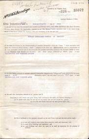
Document - MCCOLL, RANKIN AND STANISTREET COLLECTION: INDENTURE, GOLD MINING LEASE CROWN AND RONALD ALEXANDER RANKIN, BENDIGO, 24th June 1941
6 page document, Gold Mining Lease 11166, plus map. Indenture between Crown (King George VI) and Ronald Alexander Rankin of Bendigo, dated 24th June, 1941. Map No. 11166 Bendigo, Mining District of Bendigo, Parish of Sandhurst, County of Bendigo. Map shows lease 11166 marked in yellow with shaft, ore bins and tramway marked. Belle Vue Road , Adam Street and Griston Street shown on map. ( Golden Gully area) Dams indicated on lease holdings. Other lease holdings: 1675 T.L.9858, 10990, 11013, 11062, 11165, 11063 (void) 1172 W.R. (dam thereon) 9882 (void). Some residential lots marked along Belle Vue Road, and Adam Street. On bottom of map 21.8.41 in pencil. On last page of document : North Deborah Mining Company now the proprietor of the within described estate by transfer registered on 11th November 1914.bendigo, mining, north deborah lease, belle vue road, adams street, griston street, golden gully, ronald alexander rankin, north deborah mine. -
 Bendigo Historical Society Inc.
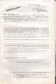
Document - MCCOLL, RANKIN AND STANISTREET COLLECTION: INDENTURE GOLD MINING LEASE 9201 BALLAARAT
6 page document plus map: indenture, gold mining lease dated 9th August 1960, between the Crown and North Deborah Mining Company, carrying on operations in the Parish of Moorarbool West . Key on map indicates depth to which land may be excised. On map: Mining District of Ballarat, County of Grant, Parish of Moorarbool West. Total area: 285 acres 1 rood, 20 perches. Vol 334, Fol 202.bendigo, mining, deborah gold mines -
 Bendigo Historical Society Inc.
Document - MCCOLL, RANKIN AND STANISTREET COLLECTION: INDENTURE BETWEEN KING EDWARD VIII AND MONUMENT HILL CONSOLIDATED MINE, 2/09/1936
Indenture document number 10878, Vol 317 Folio 35044. Foolscap 4 pages including a map, dated 2nd September, 1936, between King Edward VIII (Crown land) and Monument Hill Consolidated (Bendigo) No Liability 'carrying on operations in the Parish of Sandhurst, to occupy and use the land demised as a site for machinery buildings and offices to be used in connexion with 'mining purposes' ' Document signed by Right Hon William Charles Arcedeckne, (Baron Huntingfield) and J. Stanistreet, Manager, affixed with the Common Seal of Monument Hill Consolidated (Bendigo) No Liability. Map drawn on dark buff paper, and fixed to document. Map shows lease 10878 in the Mining District of Bendigo, Parish of Sandhurst, County of Bendigo. N.Area 2.2.24 ( 2 acres, 2 roods, 24 perches ) Lease site on Rowan Street, bordered by Ophir Street. Coloured in purple on plan with small red area. On bottom: ' Note Red Areas Excised. Scale 4 chains to 1 inch, M.M. Var. 8 degrees 32' E. On lease site, New Chum Gully marked, W.B. House, and Permanent Occy. marked on red area. On last page ownership of lease details from 1937 to 1942.bendigo, mining, monument hill consolidated, common seal of monument hill consolidated, nell gwynne mine, south nell gwynne gold mining company, bendigo mine, ophir street, rowan street, mackenzie street.indenture vol 317 fol. 35044. j stanistreet. -
 Bendigo Historical Society Inc.
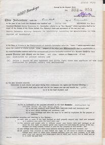
Document - MCCOLL, RANKIN AND STANISTREET COLLECTION: INDENTURE NORTH DEBORAH MINING COMPANY, 20th November, 1952
6 page document ' Gold Mining Lease Crown land Number 11307 Bendigo' plus map. Indenture document between Queen Elizabeth 11 and North Deborah Mining Company No Liability, Parish of Sandhurst, dated 20th November, 1952 re Vol 333, Folio 053. Land indicated by yellow on map and below ' a depth of one hundred and fifty feet from the surface of the land indicated by purple colour and delineated on the plan' Document signed by J. Stanistreet, Manager, North Deborah Mining Company No Liability. Map, fixed to document, heading ' Mining District of Bendigo, No. 11307, County of Bendigo, Parish of Sandhurst, Total area 13 acres 2 roods, 11 perches. Map shows large dam on Crown land, transmission line excised 150 ft., written on purple area. Underneath map ' provided that the dam indicated on the said plan is hereby reserved'.bendigo, mining, north deborah mining company -
 Bendigo Historical Society Inc.
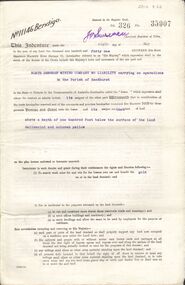
Document - MCCOLL, RANKIN AND STANISTREET COLLECTION: LETTER RE LEASE 10931, 23rd January, 1942
2 page letter from Bendigo Mines No Liability, 360 Collins Street, Melbourne to Manager, Central Nell Gwynne Gold Mining Co., N.L., dated 23rd January 1942. Letter deals with the sale from Nell Gwynne Mines, to Central Nell Gwynne Company G.M.L., No. 10931. 'located within the boundaries of this lease was the main shaft of Nell Gwynne (B.M.L. ) Mines N.L. 'previous to this sale the leases held by the Nell Gwynne company had been consolidated into G.M.L. 10931 but a machinery area No 10878 also held by the Company covering the area around the main shaft to a depth of 25ft was not included in the consolidation owing to some technical objection by the Mines Department'bendigo, mining, bendigo mines no liability -
 Bendigo Historical Society Inc.
Document - MCCOLL, RANKIN AND STANISTREET COLLECTION: MAP OF MINE LEASES SYMONDS STREET, MCKENZIE ST WEST AREA BENDIGO, 2nd September, 1936
Blue waxed linen paper map. On top' Mining District of Bendigo' Parish of Sandhurst, County of Bendigo' Map shows lease 10135, area 32.1.19; lease 10371, area 30.0.23; lease 10179 area 41.3.4; lease 10370, area 49.0.1. Map indicates gully leading into and State Rivers and Water supply reservoir, water race; siphon, shaft, dam, residential area and some residential lots marked. Streets include Holly Street, MacKenzie Street West, Symonds Street, Aspinall Street, Emmett Street; Bendigo Creek marked at bottom of map. Scale 4 chains to one inch. Map is not dated.bendigo, mining, mccoll rankin & stanistreet -
 Bendigo Historical Society Inc.
Document - MCCOLL, RANKIN AND STANISTREET COLLECTION: MEMO BENDIGO MINES L. EDWARDS
Memo - Bendigo office. Stamped received 27 January, 1942. Memo re transfer to Central Nell Gwynne as purchasers and vendor Nell Gwynne (BML) re their right to leave machinery on 'this area'.bendigo, mining, south nell gwynne -
 Bendigo Historical Society Inc.
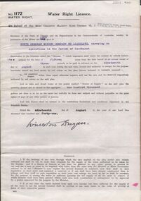
Document - MCCOLL, RANKIN AND STANISTREET COLLECTION: WATER RIGHT LICENCE NORTH DEBORAH MINING COMPANY NO LIABILITY, 19th August, 1941
4 page document plus map, Water Right Licence No. 1172, between King George VI ( the Crown ) and North Deborah Mining Company No Liability, Parish of Sandhurst., dated 19th August 1941. "to take and divert water at the points marked 'source of supply' on the said plan the quantity thereof not to exceed in the aggregate one hundred thousand gallons per diem' Plan: 'Mining District of Bendigo No. 1172 W.R., County of Bendigo, Parish of Sandhurst. Plan has dam area coloured in red, with pipe line drawn in red, leading from Battery marked on lease 11145 across lease 9988 to dam. Streets marked: Adams Road, Honeybone Street, Griston Street. (Golden Square area)bendigo, mining, north deborah mining company, north deborah mining company, adams, honeybone, and griston streets. (golden square) -
 Bendigo Historical Society Inc.
Document - MCCOLL, RANKIN AND STANISTREET COLLECTION: GOLD MINING LEASE NORTH DEBORAH MINING COMPANY, 6th May, 1941
6 page indenture document plus plan, between King George VI and North Deborah Mining company, no liability, Parish of Sandhurst, dated 6th May 1941. Lease number 11146 Bendigo. ' all that piece of land above a depth of one hundred feet below the surface of the land delineated and coloured yellow' Signed by J. Stanistreet, manager. Plan shows excised area in pink. Excised below 100ft shown in yellow ( lease 11146 ) On top of plan ' Mining district of Bendigo, County of Bendigo, Parish of Sandhurst. Area section has been amended to show 1 rood, 14 perches. Leases on plan : No. 9988, 11013, 11062, 11033, 11146, 10753, 11020. Streets: Sullivan Street, Hargreaves Street, Violet Street, Queen Street, King Street. Railway line shown. Scale 8 chains to 1 inch.bendigo, mining, north deborah mining company, north deborah mine, j stanistreet, sullivan heargreaves, queen, king streets. -
 Bendigo Historical Society Inc.
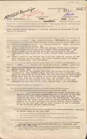
Document - MCCOLL, RANKIN AND STANISTREET COLLECTION: GOLD MINING LEASE NORTH DEBORAH MINING COMPANY, 29th August, 1950
6 page indenture, plus plan, between King George V and North Deborah Mining Company in the Parish of Sandhurst, dated 29th August, 1950 to operate a gold mine. Indenture numbered 11231 Bendigo, Vol 331 and Folio 36457. Plan shows Hargreaves Street, Violet Street, Lily Street, Sullivan Street railway line, and leases numbered, 11230; 2107; 11062, 11033, 11013, 11219, 11175. Shafts and tracks indicated. Dam shown on lease 11013. Scale 8 CHAINS TO A INCH. Coloured key to plan shows depths, Crown Land, and surface excised. Total area of lease 48 acres, 3 roods, 22 perches.bendigo, mining, north deborag mining company, north deborah mining company, hargreaves, violet, lilly, sullivan streets. -
 Bendigo Historical Society Inc.
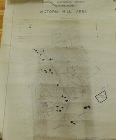
Map - VICTORIA HILL AREA
Contour plan of the Victoria Hill area, with all of the historical features marked and namedCompiled by AHQ Survey Regt. CMF increment May 1971map, reserves, mining, bendigo goldfield, victoria hill -
 Bendigo Historical Society Inc.
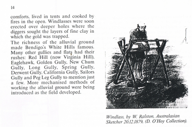
Document - LONG GULLY HISTORY GROUP COLLECTION: SOME HISTORICAL INFORMATION
BHS Collection12 photocopied pages. Page four has acknowledgements, Page five mentions Pen-Portraist by Raly Wallace and Kevin Vallence, Page 14 mentions some rich areas: White Hills, Red Hill (now Virginia Hill), Eaglehawk, Golden Gully, New Chum Gully, Long Gully, Spring Gully, Derwent Gully, California Gully, Sailors Gully and Peg Leg Gully. There are two sketches on the page: Windless, by W. Ralston, Australasian Sketcher 20/12/1879 (D O'Hoy Collection) and a sketch of some miners in a tent with some mining equipment in front of it. There are two men in front of a fire at the front of the tent. Page 16 has a sketch of an old brick house with iron lace on the veranda and a picket fence at the front. Page 17 mentions the school and some Friendly Societies and Church. Page 22 mentions Quartz Mining. There is a Lithograph of a Quartz outcrop, New Chum Gully 1852 by George Rowe and a View of Surface Workings 1861, a Batchelder Photo. Page 23 mentions Edward Nucella Emmett, a pioneer gold digger who became involved in many important public issues. Page 25 mentions Company Mining and Crushing. It has a sketch of a Primitive Quart Crusher. Page 37 Mentions Richard Pope, a Miner who tramped from job to job in Bendigo and eventually followed the rush to Broken Hill. Page 38 mentions the Eaglehawk Brass Band and Friendly Societies in Eaglehawk. Page 39 is headed Miner's Cottage. It mentions stone miners' cottages. Page 40 has a sketch of a Georgian Style Sandstone Cottage Harvey Town. Page 41 mentions men sweeping the road to get gold, Bull Family grocery shop and a blacksmith. Page 42 is headed St. Augustine's. Page 43 has a sketch of St. Augustine's Church. Page 59 is headed Bendigo Amalgamated Goldfields (B.A.G.) Edward Clarence Dyason was largely behind a new company set up in 1917 to work the Bendigo field in an entirely new way. (B.A.G.) wished to take over all existing mining companies, and place them under a single management structure.bendigo, history, long gully history group, the long gully history group - some historical information, mr l hooley, mr l bennetts, mr w watson, mr w heraud, mr d m davies, mr w perry, mr h harvey, mr a llewellyn, mr e oates, chook temple by mr alan llewellyn, mr f cusack, tracey ipsen, ray wallace, bendigo field naturalists' club, eaglehawk tree lovers' society, bendigo historical society, university of melbourne, kevin vallence, monash university, bendigo technical college, south australian writer's fellowship, windlass, w ralston, australasian sketcher 20.12.1879, d o'hoy, mechanics institute, california gully school, bell topper hill, i.o.r. (rechabites), cobden tent, refuge tent, sutton tent, m.u.i.o.o.f.'s loyal darling, bible christian church, california hill wesleyan methodist church, saint jude's anglican church, quartz mining, e n emmett, jonathan harris, haris' claim, j hustler, george rowe, batchelder, la trobe library, cave, amos, new chum line of reef, edward nucella emmett, bendigo city council, all saints, william westgarth, latham and watson, hustler's line of reef, bell and irons, ballerstedt and son, young and company, nicholas and bassit, ensor, thomas carpenter, quartz crusher, goldfields and mineral districts of victoria, richard pope, daniel webster mine, isaac dyason, old chum mine, north old chum mine, young chum mine, george lansell, lazarus, silicosis of the lungs, eaglehawk brass band, victoria hotel, mr williams, eaglehawk branch of the australian natives association, loyal catherine lodge, mr james, odd fellows in the loyal catherine lodge branch no 4935, richard harvey, thomas harvey, moonta copper mines, harvey town, national trust of australia, eaglehawk tree lovers society, saint mungo's methodist church, clark's beehive battery, world war 1, kee-young, lady barkly hotel, prankhurst, bull family, cousin jack, st augustine's, myers, nicholls, john o'brien, around the boree log, the rev dean hayes, st kilian's, bendigo amalgamated goldfields (b.a.g.), edward clarence dyason, r h s abbott, hercules and energetic, south new moon, new chum goldfields, central red white and blue consolidated, brown john, the life and times of long gully, bendigo press, val white, megan snoop -
 Bendigo Historical Society Inc.
Map - MINING PLAN ,VICTORIA HILL AREA, No date visible
... MINING PLAN ,VICTORIA HILL AREA...MAP Bendigo mining plan Mining Gold Mines Victoria Hill ...Map: Large scale plan of an area of the Goldfield, Northward from Barnard Street, covering the Victoria Hill area. Black printing on polycarbonate film. Transparent.map, bendigo, mining plan, mining, gold mines, victoria hill, lines of reef -
 Narre Warren and District Family History Group
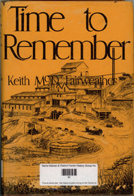
Book, Keith McDonald Fairweather, Time to remember : the history of gold mining on the Tambo and its tributaries, 1975
Contains stories of old mines in the area in great detailnon-fictionContains stories of old mines in the area in great detailtambo river valley, cassilis gold mining co, gold mines, shire of omeo -
 The Beechworth Burke Museum
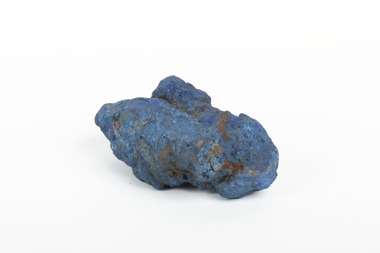
Geological specimen - Azurite, Unknown
Azurite is a secondary copper mineral made by the weathering of copper sulphide ore deposits. Azurite is formed from copper, carbon, oxygen and hydrogen. There are over 45 forms of azurite that are more well-known, however over 100 forms have been found. Azurite is also commonly found together with Malachite, and Azurite is often psuedomorphed to Malachite. This specimen was found at the Great Cobar Copper Mine in New South Wales, which was founded in 1870. At the time it was one of the largest mining operations in the world. It was the largest copper mine in Australia and housed the southern hemisphere’s tallest chimney stack. The international price of copper collapsed at the end of World War 1 which led to the closure of the Great Cobar Mine on March 16th 1919. A year later on March 10th 1920 an underground fire in the CSA (Cornish, Scottish, Australian) mine started and burned for 16 years. The closure of the mine and the fire left thousands jobless and many people left the area. These were factors in Cobar facing a long stretch of poverty, until a boom in the 1960s led to the reopening of the mine. The mine still operates today, obtained by Metals Acquisition Limited in June 2023. Azurite is considered an uncommon mineral. Named for its deep blue colour, azurite was historically used for pigment making and as a gemstone, despite its softness. This specimen was donated to the Burke Museum between 1868-1880 as part of a larger collection of geological and mineral specimens. Many of the specimens in this collection were obtained as part of the Geological Survey of Victoria, which started in 1852. The Survey aimed to map the scientific makeup of the earth.A solid copper mineral with shades of darker blues almost covering it.burke museum, beechworth, indigo shire, beechworth museum, geological, geological specimen, mineralogy, cobar mines, great cobar copper mine, cobar mining, new south wales, azurite, azurite specimen -
 The Beechworth Burke Museum
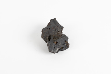
Geological specimen - Hematite (iron oxide)
Hematite is an iron ore significant for its high iron content (70%) and as being one of the two main iron oxide minerals, the other being magnetite. Hematite has a rating of 5-6 on the Moh's hardness scale and is often found as an accessory mineral in many igneous rocks. (an accessory mineral being "any mineral in an igneous rock not essential to the naming of the rock" - Britannica) Hematite has historically been the mainstay of South Australia’s iron ore production. (Magnetite: South Australia’s potential) Making up the eastern section of the Gawler Rangers, the Middleback Range is a mountain range on the eastern side of Eyre Peninsula in South Australia that has been a source of iron ore (its main commodity in minerals) for over a century. (see https://www.mindat.org/loc-22576.html). "Large reserves of high-grade iron ore were identified in 1890 in the Middleback Range, west of Whyalla. From 1915 these ores were shipped to Newcastle and later to Port Kembla, both in New South Wales. Local production of pig iron began when the first blast furnace was opened at Whyalla in 1941, and construction of an integrated iron and steel plant began there in 1958." (Britannica, South Australia: Resources and power). This area is home to 24 mines/mineral deposits (according to mindat.org, thought the Sarig Map provided by SA gov on their Energy and Mining website indicates significantly more mining leases).This mineral specimen was collected from the Middleback Ranges before the area was identified as holding large reserves of iron ore and being commercially mined and is representative of South Australia's significant and ongoing history of iron ore mining, and its contribution to Australia's steel manufacturing industry of the early 20th century (this specimen being collected in the prelude to these events).A small ferric oxide mineral composition a mid-blue-grey in colour with specks of rust-brown throughout.HEMATITE / (iron oxide) / Locality: Middleback Ranges, S. Aust.middleback ranges, iron ore mining, mining, south australia -
 Bendigo Historical Society Inc.
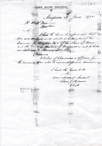
Document - ALMOND ROWE WILLIAMS COLLECTION: COPY OF LETTER
Copy of letter from the Hann Council, January 1909, regarding Almond Williams election to the Shire of Hann, Maytown Council. Hann Shire (1879-1919) was the local government area for the Palmer River goldfield, between 70 km and 150 km west of Cape Tribulation. Access from the coast was via Cooktown, 100 km to the north-east. In 1872 an expedition led by William Hann explored the interior of Cape York Peninsula. Presumably, Almond Williams went to the Palmer field after his time in Bendigo.bendigo, mining, almond williams -
 Clunes Museum
Map, DEPARTMENT OF MINES, Untitled, c1859
All maps show names and locations of mines operating in the district (see reference section link to article).1 Map of Creswick Clunes - lists 45 mines in the Clunes enlargement and 100 mines in the Creswick enlargement .2 Department of Mines map of Clunes Creswick and shows the McDonald & Co. Pre-emptive area. Indexes for quartz and alluvial mine locations .3 Topographical map Ref GF23 Clunes Mt. Greenock Talbot.1 360 Scale 1:2500 .2 303/59 33 hand written in ink "received 15 October 1859" signed by R Broughton, James Stevenson - District Mining Surveyor .3 40 chains to an Inchgold mining, dept of mines -
Stawell Historical Society Inc
Map, Easton Johnstone, Map of Stawell Surveyed by Easton Johnstone 1872, 1872
Victoria Co Crushing Machine. St Georges Co Crushing machine. Wimmera Co Crushing Machine. Government Reservoir and Drainage. Sloan Street, Skene Street Mines. old Mine WorkingsA2 map of Stawell Reefs Area. Showing Crushing Machines & Title InfoSurveyed by Easton Johnstone Contract Surveyor. Photo-Lithographed at the Department of Lands & Survey. Melbourne By J Noone 9th May 1872mining