Showing 2347 items matching " mountains"
-
 Victorian Aboriginal Corporation for Languages
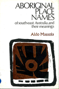
Book, Aldo Massola, Aboriginal place names of south-east Australia and their meanings, 1968
A first attempt to make a complete collection of all recorded Aboriginal names of towns, shores, homesteads, rivers, swamps, mountains and other natural features of south-east Australia. Gives meanings.word listsvocabulary, word lists, south east australian languages -
 Southern Sherbrooke Historical Society Inc.
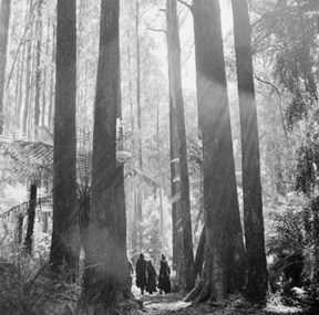
Photograph, Sherbrooke Forest 1968
Black and white photo showing a group of four or more people walking in Sherbrooke Forest between mountain ash trees. Treeferns are also visible. Created by the Australian News and Information Bureau. -
 Moorabbin Air Museum
Book - History of stages and moments of progression of aviation from gliders, balloon flight to 1990's, CONQUER THE SKY GREAT MOMENTS IN AVIATION, HAROLD RABINOWITZ, CONQUER THE SKY GREAT MOMENTS IN AVIATION, 1996
History of stages and moments of progression of aviation from balloon flight to 1990's, CONQUER THE SKY GREAT MOMENTS IN AVIATIONCover jacket showing colour photo of two fighter jest flying over snow covered mountains, clear sky, plus b&w photo of early bi-plane on groundnon-fictionHistory of stages and moments of progression of aviation from balloon flight to 1990's, CONQUER THE SKY GREAT MOMENTS IN AVIATION -
 National Wool Museum
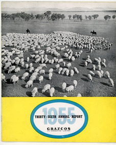
Document - Grazcos Annual Report, Grazcos Co-operative Limited, 1955
The co-operative was registered in 1919 as the Graziers Co-op Shearing Company Limited. It changed its name in September 1948 to Grazcos Co-operative Ltd. In 1981 the co-operative merged with Farmers & Graziers Co-op Ltd to form Farmers Grazcos Co-op Ltd. This item is part of a collection of Annual Reports from Grazcos dated from 1949 - 1980.Booklet featuring a black and white image showing sheep in foreground with two men on horseback in the background and mountains in the far distance, with printed black and blue text on a yellow background below image.front: 1955 / THIRTY-SIXTH ANNUAL REPORT / GRAZCOS / CO-OPERATIVE LIMITEDagricultural co-operative, agricultural wholesaling, annual reports, rural life, rural industry, business, corporate body -
 National Vietnam Veterans Museum (NVVM)
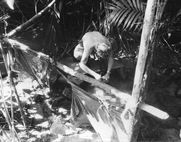
Photograph, Gibbons, Denis, Cleaning Mess Tin
Denis Gibbons (1937 – 2011) Trained with the Australian Army, before travelling to Vietnam in January 1966, Denis stayed with the 1st Australian Task Force in Nui Dat working as a photographer. For almost five years Gibbons toured with nine Australian infantry battalions, posting compelling war images from within many combat zones before being flown out in late November 1970 after sustaining injuries. The images held within the National Vietnam Veterans Museum make up the Gibbons Collection. A black and white photograph of a Digger cleans his mess tin near the wards at the K76A Hospital captured on the Nui May Tao Mountain by 6 RAR/NZ during Operation Marsden.photograph, 6 rar/nz, k76a hospital, nui may tao mountain, operation marsden, gibbons collection catalogue, digger, 6 rar/nz (anzac), denis gibbons -
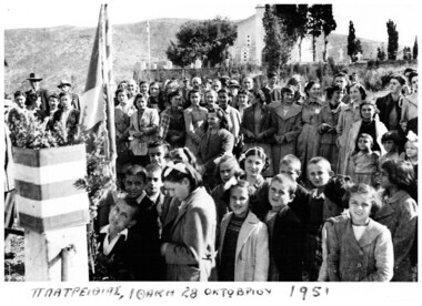 Ithacan Historical Society
Photograph, OXI Day celebration, Platrithia, 28 October 1951
The photo was taken on 'Oxi' Day 28 October 1951 which is commemorated throughout Greece and Cyprus and world-wide Greek communities. The day commemorates the rejection by the Greek prime minister, Ioannis Metaxas of the ultimatum presented to him by the Italian ambassador on the 28 October 1940 to allow the Axis forces, namely Italy, Germany and Bulgaria to occupy strategic locations of Greece or face war. A black and white photograph of a crowd of people - men, women and children - gathered around a Greek flag in an open area. A church is visible in the background. High mountains are also visible across the skyline.The original is handwritten across the bottom of the photo in Greek which translated reads: PLATRITHIA. ITHACA 28 OCTOBER 1951.world war 2 -
 Queenscliffe Maritime Museum
Functional object - Rudder, Alexander Brown
Returning from Manila in 1856 with a cargo of rice, sugar and rope. Mountain Maid was wrecked after colliding with the Victorian steamer, SS Queen. No lives were lost but the ship sank quickly and the crew was forced to swim for their lives. The pilot onboard Mountain Maid was dismissed from the Pilot service, as he'd already run two other ships aground before changing direction and causing the collision with SS Queen (Lomdahl 1992:Mountain Maid). Pintle and Gudgeon Type Ruddermountain maid, shipwrecks, rudder -
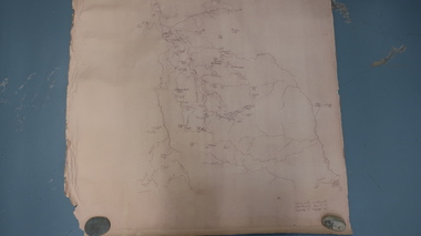 Kiewa Valley Historical Society
Map - Bogong High Plains
Bogong high Plains showing mountains, places, roads and riversHistorical changes of infrastructure on the Bogong High PlainsBogong High Plains, hand written and 'copied with considerable simplification from F.C.V. (Falls Creek V.?) 'Feathetop' L 'Tawonga'. Paper is yellowed, writing is brown.bogong high plains map -
Creswick Campus Historical Collection - University of Melbourne
Photograph - Framed photograph of a 227 ft Mountain Ash at Neerim, Vic, Mountain Ash Neerim, Vic
This is a Framed photograph of a 227 ft Mountain Ash at Neerim, VicPhotograph -
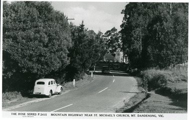 Mt Dandenong & District Historical Society Inc.
Photograph, Mountain Highway Near St. Michael's Church, Mt. Dandenong, Vic, c1950
Rose Series Postcard number 2415Copy of Rose Series post card taken c1950. St. Michael's Foundation Stone laid in 1940. Name 'Mountain Highway" is incorrect as the Mountain Highway was the Sassafras - Basin Road though it may not have received that name by 1950. The correct name is the Mount Dandenong Tourist Road at Mt. Dandenong / Kalorama as Falls Road is the boundary. Note: Heavy roadside vegetation, no white lines at side of road. White car probably pre war Vauxhall.kalorama, mount dandenong, rose series, st. michael's church, mt. dandenong tourist road -
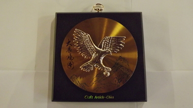 Seaworks Maritime Museum
Eagle plaque
Needs context and donar information.Composite plaque depicting a golden eagle imposed on metal disc. Mountains and Asian writing located behind the eagle. There is a metal hook located at the top and a silver coloured screw visible on the verso of the plaque.PMA0203/1 located on verso top left corner ‘Craft Article China’gifts -
 Ringwood and District Historical Society
Photograph, Ringwood from Loughnans Hill. 1948
Black and white photograph taken from hill looking across valley towards settled area. Mountains in background. Catalogue card reads, "View from Loughnans Hill looking south east" -
 Bendigo Historical Society Inc.
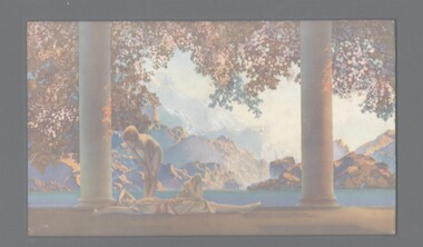
Painting - PRINT: DAYBREAK, 1920
Print titled Daybreak showing a scene of mountains, lake and 2 women between column in tones of Blue & Autumn Colours on Card with Black Mount, markings read 'Reinthall & Newman NY Daybreak'painting, print, landscape, daybreak, landscape -
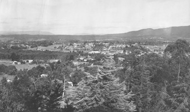
 Stawell Historical Society Inc
Photograph, Panorama of Stawell from Big Hill -- Coloured
Colour Laminated photograph and timber framed view of Stawell from Big Hill. c 1998 The Town Hall is at the center of photograph and the National Hotel on the left. The back of buildings can be seen at top of Main Street. Laminated and Framed photograph taken by Irene Read in c 1998 showing view of Stawell from Big Hill -- The Coloured photograph can be identified by trees in the foreground, Stawell township and mountains in background.stawell, panorama, streetscape -
 Linton and District Historical Society Inc
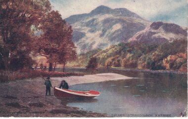
Postcard, Postcard artist - G W Hayes, Silver Strand Loch, Kataine
Pittong was formerly called Spring Vale.Coloured post card showing Loch Kataine with mountain backdrop. Stamp intact - Victoria one penny 1d. Pink-Red Postmark - Ballarat 1906. Addressed to Mrs. Johnston, Springvale, Lintons.Text, reverse: "Dear Mrs Johnston-I hope the anniversary will be a-great success and that the-weather keeps fine-Expect you will have a-good time. Love from Reita".mrs johnston, springvale (spring vale) -
 Bendigo Historical Society Inc.
Postcard - Alice McGregor Postcard Collection, 1900 - 1920
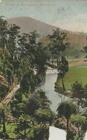
Alice McGREGOR Born: 1908; unknown parents. Possibly adopted by the Salter family? Electoral Roll 1936: Highland Terrace Kangaroo Flat. Alice Mary Salter and William Robert Salter living together; presumed to be sister and brother. William Robert Salter was killed in a MVA in Bendigo in 1937 aged 26. In Victoria in 1938, Alice Mary Salter married James Thomas McGregor (born Victoria 1917, died Victoria 1983, buried Fawkner Cemetery) Lived: 1968; 22 Wade Street Golden Square Alice McGregor Died: 1999 aged 91 at Anne Caudle Centre, Bendigo Buried: Kangaroo Flat Cemetery See additional research. Postcard Album of Alice McGregor contained 86 post cards.Postcard Album of Alice McGregor containing 86 post cards. See 1400 Colour image of a Scene at Sunnyside, Warburton, Victoria Path running beside a river with trees and a footbridge. Mountain in background Addressee - unknown Sender - H S date 2/11/05 postcard, collector, alice mcgregor -
 Glenelg Shire Council Cultural Collection
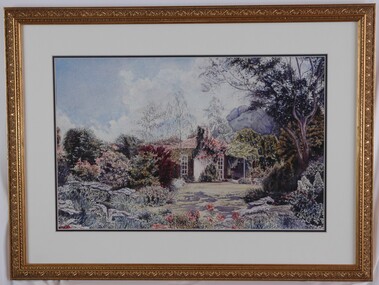
Painting, Helen Fergusson, Pat's Joy, 1998
1998 Portland Rotary Art ShowScene of a cottage in a wild garden. There is a mountain in the background of the right. Blue sky with light clouds. Mounted in cream and dark gray double matt, framed under glass in gold-coloured wooden frame.Front: Helen Ferguson Back: (no inscriptions)landscape, garden, flowers, rotary, mountain -
Lakes Entrance Historical Society
Book, Light Railway Research Society of Australia, Tall Timber and Tramlines, 1982
A short account of some of the tramlines constructed to access the mountain forests for the timber required as building material in the rapidly expanding cities and towns of Victoria. These trainlines serviced isolated sawmilling communities from c. thetransport, timber industry -
 Ithacan Historical Society
Photograph, c1960s
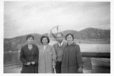
The photo is taken in Ithaca in the 1950s or 60s.A black and white photograph of three ladies and a man in front of a harbour where boats are moored. In the background there are mountains and some the faint outline of buildings along the foreshore can be seen on the left hand side.LF 7734 M 10unknown -
 Ballarat Heritage Services
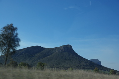
Photograph - Colour, Clare Gervasoni, Mount Sturgeon and Mount Abrupt, 17/04/2016
... mountains ...Colour photographs of Mount Sturgeon and Mount Abrupt.mount abrupt, mount sturgeon, gariwerd, grampians, mountains, mt abrupt -
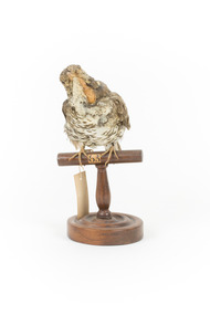 The Beechworth Burke Museum
Animal specimen - Bassian Thrush, Trustees of the Australian Museum, 1860-1880
The habitat of the Bassian Thrush includes leaf littered and canopied gullies and dense forests. It forages for food on the ground eating small invertebrates and nests in tree stumps and tree forks. Primarily found in Tasmania, South Australia and Queensland, there are three sub-species of thrush, Zoothera lunulata cuneate (Queensland), Zoothera lunulata halmaturina (South Australian and Western Bassian Thrushes) and Zoothera lunulata lunulata/Zoothera lunulata macrorhyncha (South East Australia, Queensland, Victoria and Tasmania). Because this bird is a ground foraging species, the main threat to the Bassian Thrush is the ground clearing of its habitat, and unfortunately, the South Australian Zoothera lunulata halmaturina sub-species is considered vulnerable because of the bush fires that have eliminated much of its habitat, especially on Kangaroo Island. While the overall structure of this particular representation of a Bassian Thrush is relatively accurate, some of the smaller details are lacking. The eyes within this particular specimen are not accurate. Instead of solid black eyes, this specimen has golden/yellow eyes with black pupils. Another inaccuracy is some inappropriate intrusions coming from the beak (most noticeable in the left and right close up images). From the photographs, it is unclear if this is a representative/presentation choice or a condition problem caused overtime. Unfortunately, several aging problems have also occurred over time, with the bird’s feathers fading (Bassian Thrushes have distinct dark brown and black and white scalloped plumage) and the beak which was probably once dark grey has faded to the under colour, a yellowy cream. This specimen is part of a collection of almost 200 animal specimens that were originally acquired as skins from various institutions across Australia, including the Australian Museum in Sydney and the National Museum of Victoria (known as Museums Victoria since 1983), as well as individuals such as amateur anthropologist Reynell Eveleigh Johns between 1860-1880. These skins were then mounted by members of the Burke Museum Committee and put-on display in the formal space of the Museum’s original exhibition hall where they continue to be on display. This display of taxidermy mounts initially served to instruct visitors to the Burke Museum of the natural world around them, today it serves as an insight into the collecting habits of the 19th century.This specimen is part of a significant and rare taxidermy mount collection in the Burke Museum. This collection is scientifically and culturally important for reminding us of how science continues to shape our understanding of the modern world. They demonstrate a capacity to hold evidence of how Australia’s fauna history existed in the past and are potentially important for future environmental research. This collection continues to be on display in the Museum and has become a key part to interpreting the collecting habits of the 19th century.The Bassian Thrush has white and black scalloped plumage on its underbelly with caramel, soft brown and black tipped scalloped plumage on its back. This soft brown continues onto the bird’s head and neck. The thrush has a white rim around the glass black eyes. When seen in flight, there is also a noticeable wide band across the underside of the wings which is not visible on this specimen due to its particular stance.Swing tag appears to read: ‘46a [the a is superscripted] / Mountain Thrush. / See Catalogue, Page 16. / The number in the top centre of the wooden perch reads '63'taxidermy mount, taxidermy, animalia, burke museum, beechworth, australian museum, skin, reynell eveleigh johns, bird, bassian thrush, zoothera lunulata, white's thrush, ground thrush, scaly thrush -
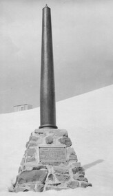 Kiewa Valley Historical Society
Photo: Memorial on the Staircase Spur Track, Mt Bogong
Mt Bogong is the highest mountain in Victoria. The Staircase Spur track to its top starts at Mountain Creek Road going through forest and continuing above the snow line to grass land. The weather can change very quickly with cloud and snow making conditions dangerous. Large sepia photo of the Memorial in snow on the Staircase Spur Track on Mt Bogong. The Memorial has a plaque attached: Sacred to the Memory / of Georgine Gadsden / Edward Neave Welch / John McRae / who perished here during a blizzard / about August 2nd 1943staircase spur memorial, mt bogong -
 The Beechworth Burke Museum
Photograph - Carte de Visite, William E Barnes
In July of 1880, Ann Jones' successful hotel in Glenrowan burnt to the ground during the Kelly siege. She had opened her business in the year prior having been unsuccessful in her attempt to run a tea-room business in Wangaratta. The first building on this particular site was the home Ann Jones had built for herself and her family. Two years later she converted the home and added the hotel to the rear of the structure. One year later it was burnt to the ground. This image depicts the streetscape of Glenrowan in 1883, three years after the siege. Importantly, it reveals the appearance of several buildings which can reveal information for how Glenrowan (as a small town) might have stood during the siege. These buildings are of typical Australian colonial "miner's cottage" style. On what would have been the site of Ann Jones' hotel, to the far left of the photograph, a police station stands. This police station was built before April 1883. This Carte-de-viste (CdV) taken by renowned Wangaratta based photographer William Edward Barnes previously belonged to the donor's grandfather, Daniel Mullins who was a Police Officer stationed at Glenrowan soon after the Kelly gang siege. Today, the siege has become an important part of Australian culture and Ned Kelly and the Kelly Gang (comprising of Ned Kelly, Dan Kelly, Steve Hart and Joe Byrne) has become ingrained in Australian history and mythology. A CdV is a sepia toned photograph mounted on card and is generally of a small size. This particular style was first patented by Andre Adolphe Eugene Disdéri (1819-1889) in 1854. In 1857, the CdV was introduced to England and after photographs of Queen Victoria, Prince Albert and their family were taken using CdV in 1860 the popularity of this method reached a peak.This photograph is part of the Burke Museum "Kelly album" which includes a significant collection of photographs and artefacts connected to Ned Kelly and the Kelly Gang. Ned Kelly and his gang have become ingrained in Australian popular culture and thus many museums, art galleries and private collections house material connected to the Kelly story which allows the events and people to be researched and interpreted. Artefacts and photographs pertaining to the Kelly gang are particularly valuable for Australian museums. This particular photograph is significant for its connection to Wangaratta based photographer William Edward Barnes and to the Glenrowan Siege and Ann Jones' Hotel which burnt down during the siege in June 1880. Taken in 1883, this photograph has the opportunity to provide information about the townscape of Glenrowan shortly after the siege. It also provides important insight into the architecture and layout of the town. To the far right of the image, the photograph depicts the police station which was built on the site of Ann Jones' Hotel which can provide important information for the Kelly story and how the town evolved following 1880. It is also interesting to emphasise that the police station was built on the site of Ned Kelly and the Kelly gang's last stand.This photograph is a sepia image mounted on yellow card which depicts the newly built police station (in 1882) which stands on the far right of the image on the site of the former Ann Jones Hotel. A fence appears through the lower front of the image and an open paddock is to the left. In the rear centre of the image, there is a mountain. In front of the mountain are many trees, most of them gum. The police station is a one storey structure with a veranda and there are three doorways visible in the image. The image depicts four windows on the front of the station.W.E.Barnes / photographer / Wangaratta / ...1882 / BMM8087kelly album, william barnes, wangaratta photographer, carte-de-viste, glenrowan, 1882, police station, ann jones inn, ann jones hotel, kelly siege, glenrowan siege, colonial australia -
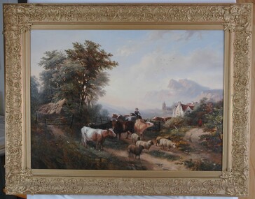 Glenelg Shire Council Cultural Collection
Painting, W.V. Tippel (?), English Farm Scene, 1853
Unknown. "Item of the Month", 2006 (Jan-July) - on display in Council Foyer (Portland Office).Scene of a man herding cattle and sheep down a country lane. To the left is a wooden pole fence and trees edging the road. On right, a path curves up and behind bushes. A man in a red coat is walking at the end of this path with his back to the viewer. In mid-ground on right is a white, thatched roof building and a church is evident behind it. In background are mountains, painted in rose and violet. Clouds sweep across the sky and mist fills the valley in front of the mountains. Framed in ornate gold-painted frame.Front: (no inscriptions evident) Back: Conservation Centre label. From previous Worksheet: W.V. Tippel, 1853. Jefferson, Artists Colours, Crystal House Baths, BRISTOL (stamp). -
 Stawell Historical Society Inc
Photograph, Magdala cum Moonlight Mine with tailings dam & the Grampians in the background. c1900's
Magdala cum Moonlight Mine. Wide view of mine with Grampians Mountains in background.Mine with snow. The Cyanide plant was constructed in Sept 1900 and became the largest in Victoria. Just in front of the large tree a ramp can be seen and a horse and dray going up the ramp. Just below and to the left of the tree the cyanide vats can be seen. On the right is the poppet head of the Magdala and Oriental and North Cross Mine. The fire station is on the left in the far distance. with the W S Heal & Sons Coachbuilders Corner of Lazelle and Byrne Street businessMagdala Cum Moonlight Mine. Herbert's Studio. Stawellstawell gold mining -
 Kiewa Valley Historical Society
Photo - Early photo of Bogong Township x2
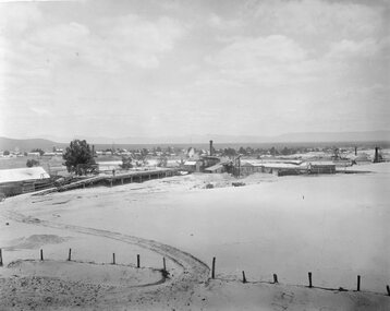
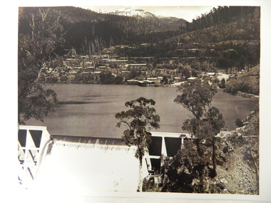
Bogong Village was built for the workers of the State Elecricity Commission of Victoria who were employed to construct the Kiewa Hydro electric Scheme. This photo shows their homes and offices etc., Lake Guy and the spillway during construction days.Bogong village was built as part of the Kiewa Hydro Electric Scheme. This photo gives a view of the village when it was at its peak. Large photo of Mt Bogong Township with snow on the mountain in the background and the spillway over-flowing in the foreground. Some small trees amongst those burnt by the 1939 bushfire. (2 photos - one an enlarged copy)bogong village. kiewa hydro electric scheme. s.e.c.v.. lake guy. -
 Bendigo Military Museum
Photograph - PHOTOGRAPH VIETNAM, FRAMED, 1968
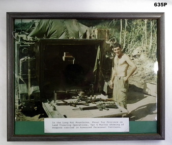
Geoff Murray No 3411521, Vietnam 3 Cav Regt 27.11.67 to 22.10.68, Survey Corp 15.10.69 to 15.10.70. Refer 638P.Colour photo, Vietnam, Long Hai Mountains, showing G Murray standing behind his APC with weapons carried laid out on the back tray. Label at bottom with details, frame is black wood.photographs, vietnam, 3 cav, weapons -
 Halls Gap & Grampians Historical Society
Photograph - B/W
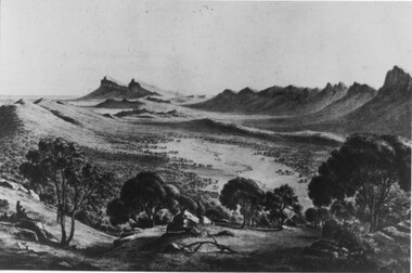
This is a photo of a lithograph by Eugene von Guerard (1811-1901), "Source of the Wannon", circa 1866-1868. The peaks in the distance are Mr Abrupt and Signal Peak.This is a photo of a lithograph. It is a stylised view of a mountain range with sharp rocky peaks with a valley through the centre. A river meanders down the valley. There are eucalyptus trees in the foreground and two figures can be seen in the left foreground.Photo printers stamp in back is "H/GAP0007 NNNAA"painting, landscape -
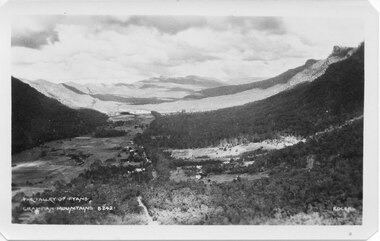 Halls Gap & Grampians Historical Society
Postcard - B/W
Photo on card was taken by Gilbert Rogers, a photographer and tour guide during the 1930s. This postcard is one of a series.Depicts as valley with mountains on both sides. Cleared land can be seen on either side of a road which runs through the valley. Buildings are also visible in middle area. View is running south-west.scenery, fyans valley -
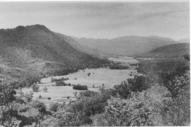 Halls Gap & Grampians Historical Society
Photograph, C 1940 -50s
Valley is now known as Fyans Valley but in the 1840-50s it was called Lady Mary's Vale. See p. 111 of 'Victoria's Wonderland' for historical information.A valley with a cleared area stretching along the valley floor. A mountain range runs along the left and into the distance of the photograph. a rocky outcrop, bushes and trees appear in the front and right of the photo. c 1940-1950sscenery, fyans valley