Showing 2278 items
matching parish.
-
 Warrnambool and District Historical Society Inc.
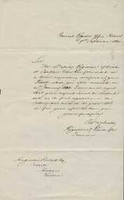
000851.1; Letter 000851.2:Copy of Baptismal entry, Augustus Bostock birth details, 000851.1. 1884. 000851.2 late 20th century
Augustus Bostock was the 9th child of Robert & Rachael Bostock of Vaucluse Epping Forest, Van Diemen’s Land. He was only 4 years old when his mother died. He was inspired by his father to seek his fortune in the Western District of Victoria. He arrived around 1850. He married Margaret Aitkin in July 1865. Augustus owned several properties in the district and leased others. He sat on the court of Warrnambool, Mortlake or Hexham as required. He resided at Marramook in Hawkesdale and later moved to Vaucluse in Hopetoun Road Warrnambool, where he died in 1920 at the age of 87. He was involved in many aspects of life in the Western District, racing, cricket, and social activities to name a few. These two documents relate to the registration of Augustus Bostock’s birth 14/01/1833. This is one of a number of documents which relate to the Bostock family who were one of the most important pioneering families of the Western District. They owned and leased various properties around Warrnambool and were involved in many aspects of social and business life. This is a personal document which confirms details of the birth of Augustus Bostock.000851.1. Handwritten letter from General Register Office Hobart. Foolscap sized lined white paper with writing in black ink. 000851.2 Copy of baptisms in the parish of Campbelltown 1835. Handwritten entries in chart form with handwritten entries. 000851.1 General Register Office Hobart. 000851.2 Parish of Campbelltown in the county of Cornwall 1835. warrnambool, augustus bostock, robert and rachael bostock, campbelltown, hobart 1835. -
 Wonthaggi & District Historical Society
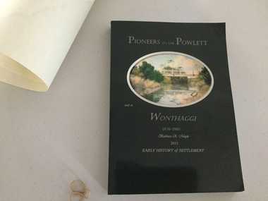
Book and Map, Barbara Moyle, Pioneers on tthe Powlett and at Wonthaggi 1878-1910, 2015
Book - families social histories, maps, photograps Map - block numbers town names physical / geographical featuresFarming and social history of pioneers of the Powlett River are prior to the establishment of the State Coal Mine at Wonthaggi. Significant land marks, buildings and photographs are included. Dark green cover with oval artists impression of Powlett river and bridge Associated map which covers the parishes plus key places of interestlPioneers on the Powlett and at Wonthaggi 1878-1910 Barbara R Moyle 2015 Early History of Settlement Map - Parish names, significant sitesfarming, pioneers of wonthaggi and district, wonthaggi families -
 Linton and District Historical Society Inc
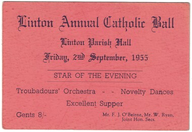
Ticket, Linton Annual Catholic Ball, 1955
Salmon coloured cardboard ticket with blue printed text. Ticket is for a ball held at Linton Parish Hall, Friday, 2nd September 1955.Text: " Linton Annual Catholic Ball / Linton Parish Hall / Friday, 2nd September, 1955 / STAR OF THE EVENING / Troubadours' Orchestra Novelty Dances. "linton annual catholic ball, linton parish hall -
 Whitehorse Historical Society Inc.
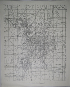
Map, Directory Maps of the County of Bourke, 1892
Directory maps of the County of Bourke, containing all the Parishes ...Directory maps of the County of Bourke, containing all the Parishes ... also a complete map of the Colony of Victoria, showing all the Counties, Parishes, Railways and stations to date, and the Mallee Blocks. Lithographed by G.S.B. Bonney for the Victorian Shire Map Company. Scale: 40 chains to the inch.Directory maps of the County of Bourke, containing all the Parishes ...maps, victoria. county of bourke, t.r.b. morton & son -
Surrey Hills Historical Society Collection
Work on paper - Newsletter, Holy Redeemer - St Joseph's Weekly Notice Sheet, c 14 December 1967
In 1901, Fr George Robinson, Parish Priest of Camberwell purchased the present site of Our Holy Redeemer Church, Surrey Hills, which at the time came within the Camberwell Parish. The owner of the land was reluctant to sell to the Catholic Church, but Miss Amy Castles, a noted singer and friend of Fr Robinson, purchased the land in her own name and then transferred it to the church. On 11 May 1902, the Church of the Most Holy Redeemer (the original title of the church) was blessed and opened by Archbishop Thomas Carr, Archbishop of Melbourne. The architect was A. A. Fritsch. The cost was £3,500. In 1904, Fr. Robinson constructed a weatherboard school-hall (later replaced by a brick hall). Archbishop Mannix opened and blessed the new brick school on 10 November 1918. Fr Tim Fitzpatrick was the third parish priest and served from 1941-1972. A slightly yellowed foolscap sheet printed on both sides detailing the activities of the Surrey Hills parish around Easter in April 1972.st joseph's convent, holy redeemer, catholic church, fr tim fitzpatrick, fr n mackay, b mcdonald, j moloney, k lourey, r kennedy, francis baker, mary gertrude mier, veronica fitton, dorothy erwin, terry young, carmel young, junior youth club, joan murphy, mr hurley, mrs kit o'neil, pat galletti, mothers' club, ed curmi, peter burns, angela lamaro, mary owen, helen buckley, p heffernan, n griffith, g mooney, a dignam, e rankin, d mooney, sister margarida -
 Bendigo Historical Society Inc.
Map - CAMPBELL COLLECTION: BENDIGO AND DISTRICT MAPS
Map. Sandhurst and suburbs, Parish of Sandhurst, Parish of Huntly, Parish of Nerring, Parish of Marong, Parish of Lockwood, Parish of Wellsford, Parish of Strathfieldsaye, Parish of Mandurangmap, bendigo, parishes -
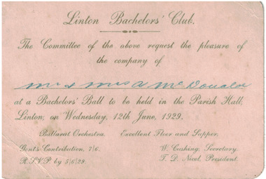 Linton and District Historical Society Inc
Card - Invitation, Linton Bachelors' Club, 1929
Cream coloured card with gold embossed text. Invitation to Linton Bachelors' Club Ball held at Linton Parish Hall on June 12th, 1929.Text: ' Linton Bachelors' Club / The Committee of the above request the pleasure of / the company of / Mr. & Mrs. A McDonald / at a Bachelor's Ball to be held in the Parish Hall, Linton; on Wednesday, 12th June, 1929. 'linton bachelors' club, dances, entertainment -
Clunes Museum
Certificate - CERTIFICATE WITH SEAL, 1928
REVEREND FRANK GIRDLER APPOINTED TO THE PARISH OF CLUNES, APPOINTED TO REPLACE PREVIOUS INCUMBENT BY RESIGNATION, WILLIAM AUGUSTE WILSON 15/8/1928A CERTIFICATE APPOINTING THE REV. FRANK GIRDLER TO THE PARISH OF CLUNES, DATED 15TH AUGUST, 1928, WITH SEAL FROM THE BISHOP OF BALLARAT ,PHILIP CHARLES THURLOWVICAR OF CLUNES REVEREND F. GIRDLER, AUGUST 15TH 1928 - 33local history, certificates, st-pauls anglican -
 Bendigo Historical Society Inc.
Map - CAMPBELL COLLECTION: BENDIGO AND DISTRICT MAPS
Map. Parish of Sandhurst, Parish of Huntly, Parish of Nerring, Parish of Marong, Parish of Lockwood, Parish of Wellsford, Parish of Strathfieldsaye, Parish of Mandurang. Scale approx 1:18,000.map, bendigo, parishes -
 Kiewa Valley Historical Society
Parish Maps - Kiewa Valley
The Parish Maps show how the Counties were divided into allotments for buyers. On one the original owners are named and the sizes of their properties given. The reference numbers enable individuals research the history of the property. The other is on a smaller scale giving only the allotment numbers. The map with the names gives information on the early settlers of the Kiewa Valley. They show how the Kiewa Valley was divided up into allotments for town dwellers and farmers and enables further research.Two copies of Parish Maps of the towns in the Kiewa Valley. One gives the original owners and the other the reference numbers of the allotments.kiewa valley. parish maps. land owners -
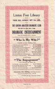 Linton and District Historical Society Inc
Programme, "Standard" Typ., Linton, The Linton Amateur Dramatic Club, 1935, 1935
Advertises the Linton Amateur Dramatic Club night of "dramatic entertainment", to be held in the Parish Hall on September 21st 1935 to raise funds for the Linton Free Library.Cream sheet with 1cm decorative red border.Text: " Linton Free Library / PARISH HALL, SATURDAY, SEPT. 21st, 1935 / THE LINTON AMATEUR DRAMATIC CLUB / Will Assist the Library with a Grand / DRAMATIC ENTERTAINMENT. "linton amateur dramatic club, programmes, jack sheehan, clem o'beirne, h. p. bennett, h.a. mccorkell, j. collins, annie o'beirne, celia kennedy, daisy smith, kath cunningham, lionel sparrow -
 Federation University Historical Collection
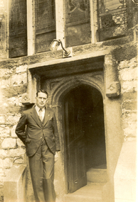
Photograph - Black and White, Frank Wright, St Andrew's Plymouth, 1934, 19/6/34
Frank Wright was a renown resident of Smeaton, where he was born. He lived at Laura Villa, and attended Smeaton State School. His father William was a gold miner and his mother's name was Sarah. Their family won many singing and instrumental awards. Frank was tutored by Percy Code and was awarded a gold medal for the highest marks in the ALCM examinations in the British Colonies at the age of seventeen years. He became the Australian Open Cornet Champion by the age of eighteen. A year later, Frank conducted the City of Ballarat Band, and later the Ballarat Soldiers’ Memorial Band. He formed the Frank Wright Frisco Band and Frank Wright and his Coliseum Orchestra. These bands won many South Street awards, and Frank as conductor won many awards in the Australian Band Championship contest. In 1933 Frank Wright sailed to England to conduct the famous St Hilda’s Band and was later appointed Musical Director of the London County Council, where he organized many amazing concerts in parks, in and around the London district. He was made Professor of Brass and Military Band Scoring and conducted at the Guildhall of Music and Drama. Frank was often invited to adjudicate Brass Band Championships around Europe, in Australia, including South Street and in New Zealand. The Frank Wright Medal at the Royal South Street competition is awarded to an individual recognized as making an outstanding contribution to brass music in Australia.Black and white photograph of a man dressed in a suit standing leaning against the entrance surround of an ornate stone door of a church. Above the door is the lower part of a four sectioned stained glass window. The man is Frank Wright and the place is St. Andrew's Parish Church in Plymouth.Written in pencil on the back - Frank Wright 32, outside St Andrew's Parish Church (13th Century), Plymouth 19-6-34frank wright, conductor, st andrew's parish church, plymouth, church door -
Whitehorse Historical Society Inc.
Map, Parishes of Bulleen, Boroondara, Prahran and Nunawading, 1850
Photocopy of map and tables of corners of allotments.Photocopy of map and tables of corners of allotments. Note on verso: Nunawading, Boroondara, Prahran. Allotments in the Parish surveyed by Lindsay Clarke 1850 (note by Robert Hoddle, surveys by Unwin, Elgar and Dendy indicated)Photocopy of map and tables of corners of allotments. maps, parish of bulleen, parish of boroondara, parish of prahran, parish of nunawading, clarke, lindsay, hoddle, robert -
City of Moorabbin Historical Society (Operating the Box Cottage Museum)
Book - The Living Harvest - A history of St. Peter's Parish, East Bentleigh, by W. T. Dobson, 1974
The first building that was erected in the Parish of St Peter's was a little wooden school house, built by local market gardeners in February 1865. The school was demolished and a brick school building was erected and opened in1903. St Peter's School, East Bentleigh was erected by the many Irish Market Gardeners of Moorrabin in 1865 and was integral to the education, spiritual well being and social life of the early settlers.A book on the history of St Peter's Parish, Centre Road, East Bentleigh, with pictures. 57 pages. Contains local history, history of early pioneer families, St Peter's School and the church.early settlers, parish of moorabbin, city of moorabbin, county of bourke, shire of moorabbin, market gardeners, center road, irish settlers, east bentleigh, st peter's church east bentleigh, religion, catholic -
Moorabbin Air Museum
Document (item) - Fatigue Test Results And Analysis Of 42 Piston Provost Wings
By H.E. Parish A.F.R.Ae.S. -
 Uniting Church Archives - Synod of Victoria
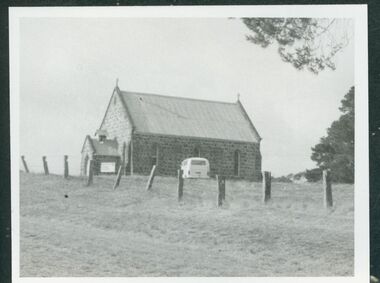
Photograph - B&W Photograph, Moyston Uniting Church
Moyston: Ararat Parishmoyston presbyterian church, moyston uniting church -
Clunes Museum
Container - ENGRAVING & BOX
INFORMATION ON BOX LID-THE ENCLOSED IMPRESSION EXHIBITS A LIKENESS OF THE REV. JOHN WESLEY, ENGRAVED ON A FOSSIL ECHINUS, OR SEA-EGG, IN THE POSSESSION OF MR. JOHN HEY OF LONDON. THE CLEVER ARTIST WHOSE WORK IT IS, PRONOUNCED THE STONE TO BE HARDEST HE HAD EVER ENGRAVED.A LIKENESS OF THE REV. JOHN WESLEY, ENGRAVED ON A FOSSIL ECHINUS, OR SEA-EGG. IN A SMALL BOX"THE WORLD IS MY PARISH"engraving, wesley, rev john wesley -
 Bayside Gallery - Bayside City Council Art & Heritage Collection
Map, Department of Crown Lands and Survey et al, Moorabbin, County of Bourke, Government Roads, 1920
The cadastral map of the Parish of Moorabbin in Victoria (L.6104) shows parish boundaries and land ownership 1920 when Sandringham was a Town. The government roads have been coloured in red pencil.moorabbin, county of bourke, map, plan, land subdivision, land titles, foreshores, hampton, beaumaris, highett, cheltenham, department of lands and survey, land owners, cartographic material, brighton, sandringham, town of sandringham, government roads -
 Bendigo Historical Society Inc.
Map - JACK FLYNN COLLECTION: SALISBURY, 1965
Map: Parish of Salisbury, County of Bendigo. Parish plan.By Authority A. C. Brooks Government Printer, Melbourne. Drawn and Reproduced at the Department of Lands and Survey, Melbourne.map, bendigo, parish plan, salisbury -
 Bendigo Historical Society Inc.
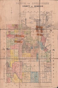
Map - JACK FLYNN COLLECTION: SHELBOURNE, 11/02/1937
Map: Parish of Shelbourne, County of Bendigo. Parish plan.By Authority, H. J.Green, Government Printer. Drawn and Reproduced at the Dept, of Lands and Survey, Melbourne, Victoria.map, bendigo, parish plan, shelbourne -
 Bendigo Historical Society Inc.
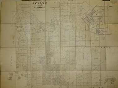
Map - JACK FLYNN COLLECTION: RATHSCAR, 14/09/1935
Map: Parish of Rathscar, County of Gladstone. Parish plan.map, gladstone, parish plan, rathscar -
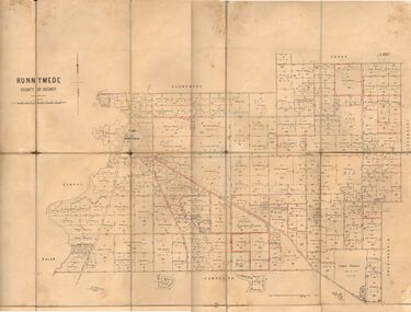 Bendigo Historical Society Inc.
Map - JACK FLYNN COLLECTION: RUNNYMEDE, June 1946
Map: Parish of Runnymede, County of Rodney. Parish plan.By Authority: J.J. Goourley, Government Printer, Melbourne. Drawn and Reproduced at the Lands and Servey, Melbourne, Victoria. June, 1946.map, rodney, parish plan, runnymede -
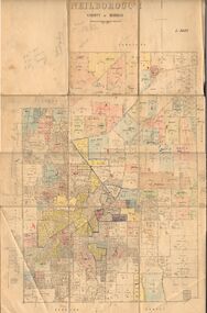 Bendigo Historical Society Inc.
Map - JACK FLYNN COLLECTION: NEILBOROUGH, 13/10/1927
Map: Parish of Neilborough, County of Bendigo. Parish plan.Photo Lithographed at the Department of Lands and Survey, Melbourne by W.J. Butsonmap, bendigo, parish plan, neilborough -
 Bendigo Historical Society Inc.
Map - JACK FLYNN COLLECTION: MUSKERRY, 1962
Map: Parish of Muskerry, County of Rodney. Parish plan.By Authority: A.C. Brooks, Government Printer, Melbourne. Drawn and reproduced at the Department of Lands and Survey, Melbournemap, rodney, parish plan, muskerry -
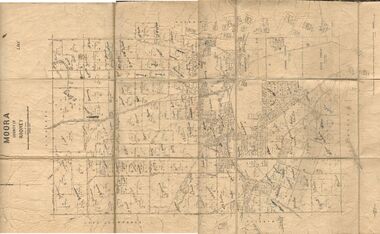 Bendigo Historical Society Inc.
Map - JACK FLYNN COLLECTION: MOORA, 9/10/22
Map: Parish of Moora, County of Rodney. Parish plan.By Authority A.J. Mullet Government Printer Melbourne. Photo Lithographed at the Dept, of Lands and Survey, Melbourne by W.J. Butson. 3.10.22map, rodney, parish plan, moora -
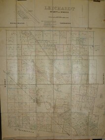 Bendigo Historical Society Inc.
Map - JACK FLYNN COLLECTION: LEICHARDT, 14/03/1`939
Map: Parish of Leichardt, County of Bendigo. Parish plan.Drawn and Reproduced at the Dept, of Lands and Survey, Melbourne, Victoria. 14.3.1939map, bendigo, parish plan, leichardt -
 Bendigo Historical Society Inc.
Map - JACK FLYNN COLLECTION: HAYANMI, March 1953
Map: Parish of Hayanmi, County of Bendigo. Parish plan.By Authority: W.M. Houston, Government Printer. Drawn and reproduced at the Dept, of Lands and Survey, Melbourne, Victoriamap, bendigo, parish plan, hayanmi -
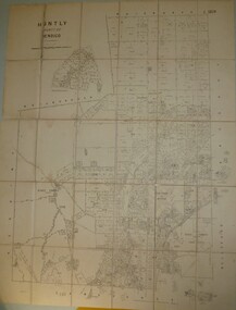 Bendigo Historical Society Inc.
Map - JACK FLYNN COLLECTION: HUNTLY, 8/09/1921
Map: Parish of Huntly, County of Bendigo. Parish plan.By Authority, Govt., Printer. A. J. Mullett. Photo Lithographed at the Department of Land and Survey Melbourne By W. J. Butsonmap, bendigo, parish plan, huntly -
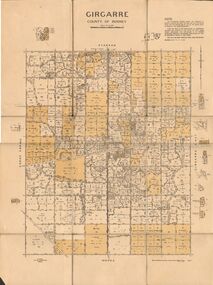 Bendigo Historical Society Inc.
Map - JACK FLYNN COLLECTION: GIRGARRE, 14/10/1943
Map: Parish of Girgarre. County of Rodney. Parish plan.By Authority, H.E. Daw, Government Printer Melbourne. Drawn and produced at the Dept of Lands and Survey, Melbourne, Victoria. 14.10.1943map, rodney, parish plan, girgarre, county of rodney -
 Bendigo Historical Society Inc.
Map - JACK FLYNN COLLECTION: BURNEWANG, 17/09/1918
Map: Parish of Burnewang, County of Rodney. Parish plan.By Authority, H. J. Green, Acting Government Printer Melbourne. Photo Lithographed at the Department of Lands and Survey, Melbourne by W. J. Butson.map, rodney, parish plan, burnewang, rodney