Showing 113053 items
matching road
-
 Greensborough Historical Society
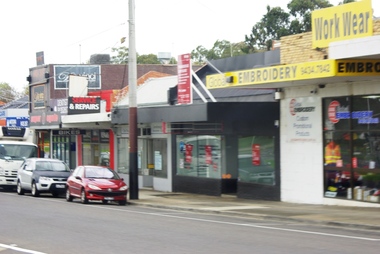
Photograph - Digital image, Marilyn Smith, Watsonia Road shopping strip 2, 2016, 24/05/2016
Watsonia Road shopping strip, Watsonia 2016. The strip is managed by the Watsonia Traders Association.Digital copy of colour photograph.watsonia, watsonia road -
 Eltham District Historical Society Inc
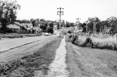
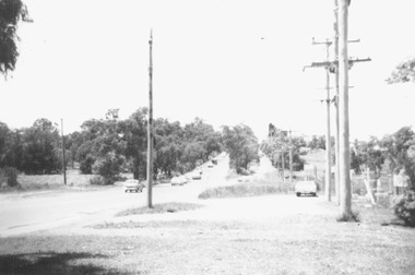
Photograph, Looking south along Main Road from just north of Elsa Court, Eltham, February 1968, Feb 1968
Shows where the future duplication of Main Road ends just north of Elsa Court.In February 1968 an unknown person took a series of photos from the Eltham Hotel at Pitt Street heading north along Main Road through the shopping centre to just north of Elsa Court covering the length of the section of Main Road which was duplicated shortly thereafter. Shows the condition and environment of the streesscape of Main Road, Eltham immediately prior to the duplication between Pitt Street and Elsa Court through the shopping centre. Also shows a number of shops and businesses that operated at that time.Black and white photographduplication, eltham, main road, elsa court, railway line -
 Eltham District Historical Society Inc
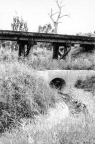
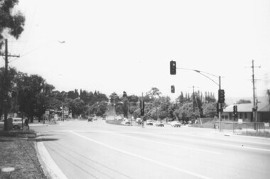
Photograph, Looking west from Main Road from just north of intersection with Diamond Street, Eltham, February 1968, Feb 1968
The watercourse passes under the road and railway at this point. Significant flash flooding occurred along this water course on Christmas Day 2011 causing significant damage to the railway line and road and flooding of Judge Book Village. The drain was swept away including the support pillars of the rail lines timber framework. Judge Book Village had some 40 units flooded before the water entered Diamond Creek. The water had flowed down and flooded Valonia Drive then Grove Street before flowing down the watercourse to Main RoadIn February 1968 an unknown person took a series of photos from the Eltham Hotel at Pitt Street heading north along Main Road through the shopping centre to just north of Elsa Court covering the length of the section of Main Road which was duplicated shortly thereafter. Shows the condition and environment of the streesscape of Main Road, Eltham immediately prior to the duplication between Pitt Street and Elsa Court through the shopping centre. Also shows a number of shops and businesses that operated at that time.Black and white photographduplication, eltham, main road, diamond street, watercourse, drainage, railway line -
 Ringwood and District Historical Society
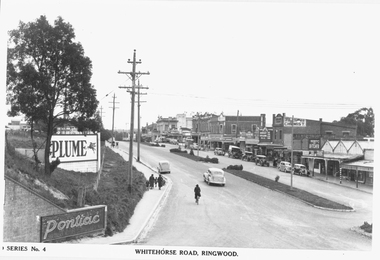
Photograph, Maroondah Highway Central, Ringwood. Whitehorse Road looking west from Warrandyte Road. c1930's
Black and white photograph (2 copies)Inscribed on photograph: "Series No 4. Whitehorse Road, Ringwood. Image shows shops on north side of road from Warrandyte Road railway bridge to Ringwood Street. -
 Ringwood and District Historical Society
Photograph, Canterbury Road, Ringwood taken under power lines looking east just east of Heatherdale Road. 1979
Written on back of photograph, "Jan. 79. Canterbury Road taken under power lines looking east just east of Heatherdale Road looking up the two-laned Road towards Cadbury McRobertsons before road widening". -
 Ringwood and District Historical Society
Photograph, Canterbury Road looking east from west side of Heatherdale Road intersection up towards Cadbury. Ringwood 1979
Written on back of photograph, "Jan. 79. Canterbury Road looking east from west side of Heatherdale Road intersection up towards Cadbury where road narrows down 3 to 1 lane. Before road widening." -
 Kew Historical Society Inc
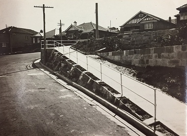
Photograph, City of Kew, Public Works, Road Making, c.1920s
An original photograph donated to the Kew Historical Society by the City's Engineering Department before the amalgamation of Kew into the City of Boroondara in 1994. While not all of the photographs are of Studley Park, Kew or East Kew, each photo provides a fine snapshot of the work of local government engineering departments of the period. They reveal they types of labour conducted, the techniques used and the equipment and machinery in the possession of the local government authority.Public works. A high retaining wall holds back an embankment on a steep slope around which a road turns. It is believed that the photograph dates from the 1920s. Inscription on reverse: "A difficult corner designed to obviate the use of steps. / Pedestrians using the road in front of the dwellings step off the pathway at the telegraph pole".city of kew (engineering department), engineering, road construction building -
 Kew Historical Society Inc
Photograph, J F C Farquhar, A View in Studley Park Road, 1891
At the beginning of the 1890s, the Kew businessman and Town Councillor, Henry Kellett, commissioned J.F.C. Farquhar to photograph scenes of Kew. These scenes included panoramas as well as pastoral scenes. The resulting set of twelve photographs was assembled in an album, Kew Where We Live, from which customers could select images for purchase.The preamble to the album describes that the photographs used the ‘argentic bromide’ process, now more commonly known as the gelatine silver process. This form of dry plate photography allowed for the negatives to be kept for weeks before processing, hence its value in landscape photography. The resulting images were considered to be finely grained and everlasting. Evidence of the success of Henry Kellett’s venture can be seen today, in that some of the photographs are held in national collections.It is believed that the Kew Historical Society’s copy of the Kellett album is unique and that the photographs in the book were the first copies taken from the original plates. It is the first and most important series of images produced about Kew. The individual images have proved essential in identifying buildings and places of heritage value in the district.This is the earliest known photograph of the exterior of Byram (later Tara Hall). It shows the original red brick fence, its asymmetrical gate and gateposts, with a large terra cotta gargoyle surmounting the higher of the two. The architect, Edward Kilburn designed Byram in the Arts & Crafts style for the industrialist George Ramsden. Construction began in 1888 and was reputed to have lasted three years. The mansion had frontages to Studley Park Road and Stevenson Street, including gardens laid out with great taste, including pleasure grounds, tennis lawn, fruit and flower garden, and paddock. The size of many of the trees in the garden indicate that many survived from the garden of Clifton Villa, the previous single-storeyed house built on the site by the Stevenson brothers. Byram had views to Melbourne and Port Phillip Bay. The house was demolished in 1960, despite opposition from the National Trust (Victoria), and its gardens subdivided into residential allotments.A View in Studley Park Roadkew illustrated, kew where we live, photographic books, henry kellett, byram, tara hall, goathlands -
 Whitehorse Historical Society Inc.
Article, $3.4 million road development opened
Article about the opening of home units for the agedArticle about the opening of home units for the aged in the former migrant hostel site in Rooks Road, Nunawading. With photo.Article about the opening of home units for the agedretirement homes and villages, harrowfield, john, mccutcheon, andrew, bradley, norman, bradley, agnes, rooks road, nunawading -
 Eltham District Historical Society Inc
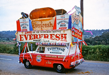
Photograph, Heidelberg Bakery display, Ersilac Parade, Main Road, Eltham, c.1960, 1960c
Heading south along Main Road approaching Bridge Street. Registration GIB is c.1955Digital file only (Wes's 35mm)don muir collection, heidelberg bakery display, ersilac parade, main road, eltham, c.1960 -
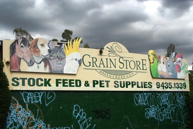 Greensborough Historical Society
Photograph - Digital Image, Marilyn Smith, Greensborough Grain Store, 183 Para Road. Signs, 06/11/2017
This photograph shows signage at 183 Para Road when the building was used for Greensborough Grain Store.Digital copy of colour photographgreensborough grain store, para road greensborough -
 Greensborough Historical Society
Photograph - Digital Image, Marilyn Smith, Greensborough Grain Store, 183 Para Road. Exterior, 06/11/2017
This photograph shows the exterior of the building at 183 Para Road when it was used for Greensborough Grain Store.In 2017, the Greensborough Grain Store closed its Para Road premises and now trades online.Digital copy of colour photographgreensborough grain store, para road greensborough -
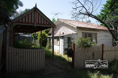
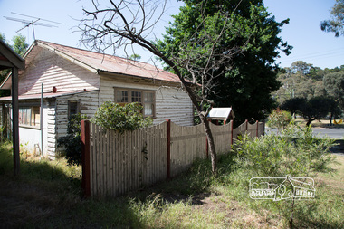
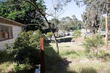
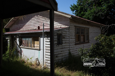
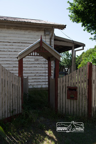
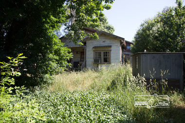
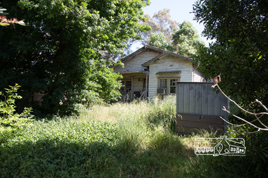
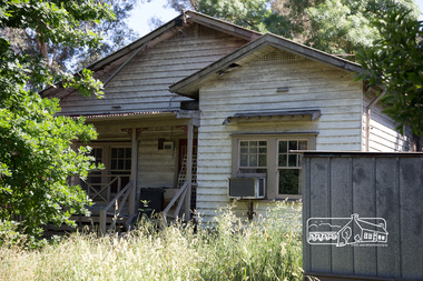
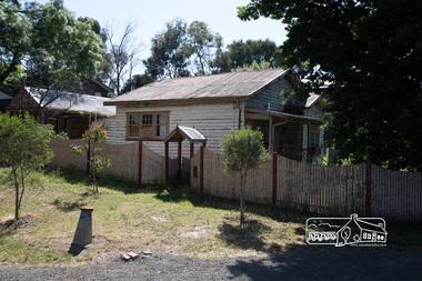
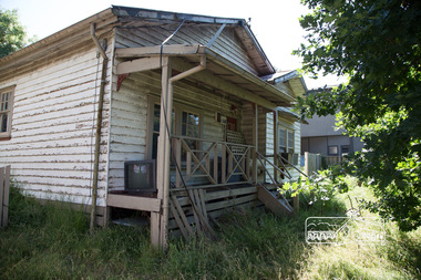
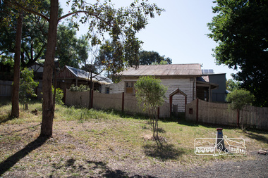 Eltham District Historical Society Inc
Photograph, Peter Pidgeon, Derelict house, 528 Main Road, Eltham, 13 November 2017, 13/11/2017
House dates back to early 1930s. Situated adjacent to intersection of Main Road and Fitzsimons LaneBorn Digitaleltham, streets, main road, fitzsimons lane -
 Eltham District Historical Society Inc
Photograph, Peter Pidgeon, Derelict house, 528 Main Road, Eltham, 13 November 2017, 13/11/2017
House dates back to early 1930s. Situated adjacent to intersection of Main Road and Fitzsimons LaneBorn Digitaleltham, streets, main road, fitzsimons lane -
 Eltham District Historical Society Inc
Photograph, Peter Pidgeon, Derelict house, 528 Main Road, Eltham, 13 November 2017, 13/11/2017
House dates back to early 1930s. Situated adjacent to intersection of Main Road and Fitzsimons LaneBorn Digitaleltham, streets, main road, fitzsimons lane -
 Eltham District Historical Society Inc
Photograph, Peter Pidgeon, Derelict house, 528 Main Road, Eltham, 13 November 2017, 13/11/2017
House dates back to early 1930s. Situated adjacent to intersection of Main Road and Fitzsimons LaneBorn Digitaleltham, streets, main road, fitzsimons lane -
 Eltham District Historical Society Inc
Photograph, Peter Pidgeon, Derelict house, 528 Main Road, Eltham, 13 November 2017, 13/11/2017
House dates back to early 1930s. Situated adjacent to intersection of Main Road and Fitzsimons LaneBorn Digitaleltham, streets, main road, fitzsimons lane -
 Eltham District Historical Society Inc
Photograph, Peter Pidgeon, Derelict house, 528 Main Road, Eltham, 13 November 2017, 13/11/2017
House dates back to early 1930s. Situated adjacent to intersection of Main Road and Fitzsimons LaneBorn Digitaleltham, streets, main road, fitzsimons lane -
 Eltham District Historical Society Inc
Photograph, Peter Pidgeon, Derelict house, 528 Main Road, Eltham, 13 November 2017, 13/11/2017
House dates back to early 1930s. Situated adjacent to intersection of Main Road and Fitzsimons LaneBorn Digitaleltham, streets, main road, fitzsimons lane -
 Eltham District Historical Society Inc
Photograph, Peter Pidgeon, Derelict house, 528 Main Road, Eltham, 13 November 2017, 13/11/2017
House dates back to early 1930s. Situated adjacent to intersection of Main Road and Fitzsimons LaneBorn Digitaleltham, streets, main road, fitzsimons lane -
 Eltham District Historical Society Inc
Photograph, Peter Pidgeon, Derelict house, 528 Main Road, Eltham, 13 November 2017, 13/11/2017
House dates back to early 1930s. Situated adjacent to intersection of Main Road and Fitzsimons LaneBorn Digitaleltham, streets, main road, fitzsimons lane -
 Eltham District Historical Society Inc
Photograph, Peter Pidgeon, Derelict house, 528 Main Road, Eltham, 13 November 2017, 13/11/2017
House dates back to early 1930s. Situated adjacent to intersection of Main Road and Fitzsimons LaneBorn Digitaleltham, streets, main road, fitzsimons lane -
 Eltham District Historical Society Inc
Photograph, Peter Pidgeon, Derelict house, 528 Main Road, Eltham, 13 November 2017, 13/11/2017
House dates back to early 1930s. Situated adjacent to intersection of Main Road and Fitzsimons LaneBorn Digitaleltham, streets, main road, fitzsimons lane -
 Eltham District Historical Society Inc
Photograph, Peter Pidgeon, Derelict house, 528 Main Road, Eltham, 13 November 2017, 13/11/2017
House dates back to early 1930s. Situated adjacent to intersection of Main Road and Fitzsimons LaneBorn Digitaleltham, streets, main road, fitzsimons lane -
 Kew Historical Society Inc
Plan, F R Simms & Son, Land for Private Sale: Cnr Victor Avenue and Mont Victor Road, Kew, 1950-1960
George Rimington established The Parkhill Nursery in 1877. By 1910, it was more commonly known as Rimington’s Nurseries and well known for its sale of violets. After World War II, Rimington’s Nurseries were gradually subdivided and sold. The 38 allotments were released in sections, including lots 34 to 36 on the corner of Mont Victor Road and Victor Avenue. Previous lots in the subdivision had bordered Burke Road, Rimington Avenue, Heather Grove, and Stoke Avenue. The selling point as it had been in comparable estates for a century were the proximity to transport, schools and churches, as well as the high location and excellent views. The subdivision plan shows most of the lots in the entire subdivision: 1-11, 13-26, and 34-38. Presumably, lot 12 and lots 27-33 were still to be released.Subdivision plans are historically important documents used as evidence of the growth of suburbs in Australia. They frequently provide information about when the land was sold on which a built structure was subsequently constructed as well as evidence relating to surveyors and real estate and financial agents. The numerous subdivision plans in the Kew Historical Society's collection represent working documents, ranging from the initial sketches made in planning a subdivision to printed plans on which auctioneers or agents listed the prices for which individual lots were sold. In a number of cases, the reverse of a subdivision plan in the collection includes a photograph of a house that was also for sale by the agent. These photographs provide significant heritage information relating house design and decoration, fencing and household gardens.Subdivision plan advertising five superb home sites among lots in Burke Road, Stoke Avenue, Victor Avenue, Mont Victor Road and Heather Grove.subdivision plans - kew, rimington avenue -- kew (vic.), heather grove -- kew (vic), stoke avenue -- kew (vic.), burke road -- kew (vic.), mont victor road -- kew (vic.) -
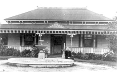 Surrey Hills Historical Society Collection
Photo, 'Spenceycroft', Canterbury Road
The photo is of ‘Spenceycroft’ at 654 Canterbury Road, Surrey Hills. For many years this home was hidden behind a large fence sheltering it from the noise of traffic along Canterbury Road, however it dates back to the very early days of settlement in the Surrey Hills area. Canterbury Road was then known as Delany’s Road. ‘Spenceycroft’ is thought to incorporate part of the original farmhouse built on the site by George Klepper, who planted a vineyard in the area. George’s family was one of a number of German families who settled in Surrey Hills during the later part of the 19th century. Later, the land associated with ‘Spenceycroft’ was worked as a dairy farm by James and Elizabeth Rayment. In recent years 'Spenceycroft' has been sold several times and has become increasingly derelict. Sold again in 2015 when it had become quite derelict, it was demolished and re-developed.A black & white photo of double-fronted Victorian style home with a fountain centre front and low foliage in front of the veranda. A woman is sitting by the fountain. 'spenceycroft', canterbury road, james rayment, elizabeth rayment, george klepper -
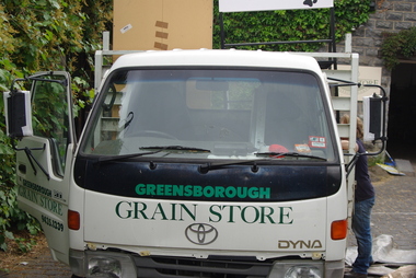 Greensborough Historical Society
Photograph - Digital Image, Marilyn Smith, Greensborough Grain Store, 183 Para Road. Delivery truck, 06/11/2017
This photograph shows delivery truck at 183 Para Road when the building was used for Greensborough Grain Store.In 2017, the Greensborough Grain Store closed its Para Road premises and now trades online.Digital copy of colour photographgreensborough grain store, para road greensborough -
Greensborough Historical Society
Photograph - Digital Image, Marilyn Smith, Greensborough Grain Store, 183 Para Road. Closure notice, 04/10/2017
This Facebook post explains the move by Greensborough Grain Store to close the business at 183 Para Road in 2017.In 2017, the Greensborough Grain Store closed its Para Road premises and now trades online.Digital copy of Facebook postgreensborough grain store, para road greensborough -
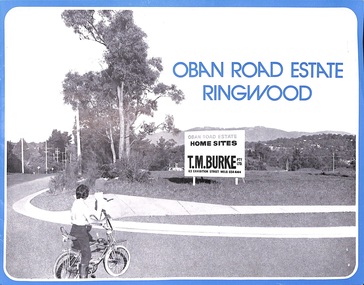 Ringwood and District Historical Society
Flyer, Land Sale Advertisement, Oban Road Estate, Ringwood, Vic. - 1974
Double-sided folded page with blue border advertising sale of Oban Road Estate Ringwood building allotments. Front page features photograph of view from the estate towards Dandenong Ranges. Centrefold pages include terms of sale, layout and features of the subdivision, and summary of local services. Photocopy of typewritten price list for the 52 lots also attached.Subdivision includes Oban Road, Ambrie Avenue, Hendra Grove, and Mullum Mullum Road. (Agent) T.M. Burke Pty Ltd., 63 Exhibition Street Melbourne, Telephone 654 4144. -
 Eltham District Historical Society Inc
Photograph, Members of the community gather on the site of the former Shire of Eltham offices, Save Community Reserves Rally, Main Road, Eltham, 4 March 2018, 4/3/2018
Protest rally against Nillumbik Shire Councillors' proposal to sell off 17 community reserves. Held at the site of the former Shire of Eltham offices, at 895 Main Road, which were demolished in August 1996, followed by a march along Main Road finishing at the Eltham Railway Station car park at Luck Street. Estimated attendance was approximately 3,000.Born digital image (8)nillumbik shire council, parks, save community reserves, protest rally