Showing 3070 items matching " scale"
-
 Bendigo Historical Society Inc.
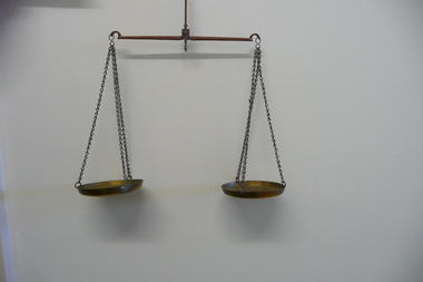
Tool - GOLD SCALES
Small brass beam gold scales.weighing, weights & measures, scales -
 Queenscliffe Maritime Museum
Leisure object - Boat Model, Barque David Clarke, John Evans, 2002
The barque David Clarke was launched in 1816 and may have been broken up at Batavia in 1854. She sailed one of the last voyages under charter to the British East India Company (EIC). In 1842 she transported more than 300 convicts to Hobart. She was last listed in Lloyd's Register in 1854.In 1839 she carried mainly Scots assisted migrants to Australia, and was the first immigrant ship to sail from the Great Britain directly to Port Phillip.Scale model of the barque David Clarkemigrant ships, convict ships, port phillip, boat models -
 Stawell Historical Society Inc
Memorabilia - Realia, 1890-1920
Salters Improved Spring Balance Scalesstawell -
 Stawell Historical Society Inc
Memorabilia - Realia
Bread Scales (Hunt & Sons)Bakerystawell -
University of Melbourne, Burnley Campus Archives
Plan, BHP Plaza 120 Collins St Melbourne, c. 1990
Possibly student workSketch plan. Scale 1:100.bhp, architecture -
Whitehorse Historical Society Inc.
Map, Melbourne Geological Map, 1937
Geological Map of Melbourne & Suburbs.Geological Map of Melbourne & Suburbs. Scale: 40 chains to 1 inch with inset 10 miles to 1 inch. Includes Municipal and Parish boundaries, railways and stations, electric tramways, cable tramways, Post Offices and State schools. Area bounded by Braybrook, Preston, Blackburn & Brighton. Printed on linen.Geological Map of Melbourne & Suburbs. melbourne, maps -
 Federation University Historical Collection
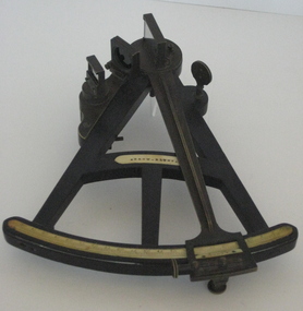
Instrument - Scientific Instrument, E. & G.W. Blunt, Sextant
A sextant is an instrument generally used to measure the altitude of a celestial object above the horizon. Sextant with a black timber (ebony?) frame, ivory graduated scales and brass attachments : vernier scale radial arm, mirrors and optical filterssextant, astronomy, scientific object, scientific instruments -
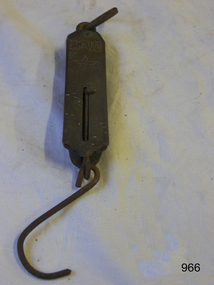
 Bendigo Historical Society Inc.
Tool - SCALE BALANCE
Scale - Balance Brass scale with 05, 10 m 20, 30. on the other side is 20 to 300. Approx 100mm x 80mm -
 Whitehorse Historical Society Inc.
Functional object - Kitchen Scales, c: 1950s
Donanted by Robert Petty Family of Petty's Orchard in Doncaster/Templestowe area. The scales were owned by Gertrude Petty (nee Pye)Kitchen scales - imperial measurement, balance scale , 25lb capacity. Enamel Painted, chrome with chrome tray. Krups brand. Made in Germany.Krups Perla, made in Germanydomestic items, weighing -
 Flagstaff Hill Maritime Museum and Village
Map - Survey Map, F.F. McGovern, Yangery - County of Villiers, 1884
A surveyor was employed to measure the land designated as Yangery, County of Villiers, in the Borough of Warrnambool. The area on the map is similar to the earlier Farnham Survey undertaken by William Rutledge in the 1850's. Warrnambool was a Borough between 1863-1883. Coutours, waterways, sea and other significant points are shown. The distances are accurately measured. This survey map was used for planning future land sales, recreation areas and roads. WILLIAM RUTLEDGE (1806-1876) William Rutledge surveyed the land known as Farnham in southwest Victoria in 1843. His tenants made him a profitable business from working the land there. In 1863 Rutledge moved from nearby Port Fairy to Farnham and became very successful in breeding sheep, which he imported from J.R. Kirkham of Lincolnshire, England. He also bred horses on his land. The survey map of Yangery is important for its connection with renowned surveyor William Rutledge. The map shows the growth of landholders in the district when compared to the original Rutledge survey of the 1850's.Survey map of Yangery, titled "Yangery - County of Villiers". Printed on white paper, mounted on brown paper. c. 1863-1876. Comments printed on the Map include; Special Survey by William Rutledge, Photo-lithographed at the Department of Lands and Survey, Melbourne by W.J. Burson, Price 1/- [one shilling]. Scale is in Chains. Map has boundaries of Koroit Borough, Meerai, Purnim, Wangoom, Borough of Warrnambool, Mentions the Proposal of Tower HIll for Public Recreation. The map names the owners of the land at that time. Hand written pencil marks and figures and "Sauls fence" drawn on map. Hand written pencil markes and figures and "Sauls fence" drawn onto map. "For Department Use only". "Scale: 8 chains to 1 inch" flagstaff hill, warrnambool, shipwrecked-coast, flagstaff-hill, flagstaff-hill-maritime-museum, maritime-museum, shipwreck-coast, flagstaff-hill-maritime-village, county of villiers map, yangery district, w.j. burson, borough of warrnambool, koroit, purnim, meerai, wangoom, proposal of tower hill for public recreation, special survey by william rutledge, william rutledge, farnham, lincolnshire sheep, clydesdale -
University of Melbourne, Burnley Campus Archives
Plan, Roh Cross, Lilydale Quarry Recreational Study for Landscape Studies, 1986
Plans on tracing paper and paper by Rob Cross Landscape Design. (1) Site Analysis No 1 dated 08.06.96. Scale 1:2400. (2.) Proposed Activity Zones No 2 dated 03.06.96. Scale 1:2400. (3) West Section of Valley No 3 dated 11.06.96. Scale 1:1000. (4) Concept Plan No 4 dated 11.06.96. Scale 1:2400. (5) Axonometric View No 5 dated 30.06.96. Scale 1:2400.lilydale, quarry, rob cross landscape design, landscape studies -
Coal Creek Community Park & Museum
Equipment - Measuring beaker
Used in Manning Chemist, Flinders Street Railway Station, Melbourne until 1984.Glass measure with small pouring lip, and graduated measurement on side. No handle ( i ) on top of measure scale VIC Pint 1- Fl oz 20, 18, 16, 14. graduations on measure scale -
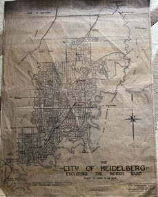 Greensborough Historical Society
Map, City of Heidelberg, City of Heidelberg, - excluding the North Ward, 1959, 27/05/1959
Map of City of Heidelberg showing municipal and ward boundaries; North Ward is excluded from this map.Blue print map"Scale 20 chns to an inch. G.M.H. 27.5.59"city of heidelberg, heidelberg - maps -
Stawell Historical Society Inc
Map - Electoral Map, Federal Government, map of Commonwealth Electoral Division of Wimmera 1949, 1949
Electoral MapMap overprinted with Electoral Divisions in Red. Description of Division of Wimmera Scale in Miles. Commonwealth of Australia State of Victoriagovernment -
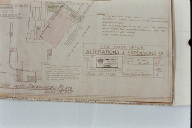 Kew Historical Society Inc
Slide - Architectural Drawing, Kew Public Offices, 1887
A civic campaign for new public offices developed in Kew in the 1880s. After much deliberation, the location chosen was the junction of Bulleen and Cotham Roads. The buildings were designed by George Watson and John Henry Harvey, architects within the Department of Public Works (Victoria). Building was commenced in 1887, and after one year, the buildings were opened. The Post Office was transferred to the new Commonwealth Government in 1901. The Police Station and Court House, sold by the Victorian Government to the City of Boroondara in 2007, are now a community cultural centre and performing arts venue.The buildings were listed on the Victorian Heritage Register Register (HO885) in 1991. They are historically and architecturally significant to the State Of Victoria because Watson and Harvey's designs exhibit diversity in integrating civil offices, they accommodate the apex of road junctions, and they demonstrate a departure from the contemporaneously favoured High Victorian Classical to the Queen Anne style in the design of civic buildings. 35mm colour transparency of an original plan by George Watson and John Henry Harvey, architects of the Department of Public Works (Victoria), in 1887 for New Public Offices at Kew. This plan was copied by the donor from an original held at the Commonwealth Archives in Brighton (Vic). The copy was made to illustrate a report that the donor made on ‘The functional planning design, building materials and construction methods of the Kew Post Office’ as part of course work at RMIT.SITE AND DRAINAGE PLAN / SCALE 16' TO 1"kew court house, kew police station, kew post office, architectural drawings, khs - slides, new public offices -- kew (vic.), architecture — queen anne style -
 Flagstaff Hill Maritime Museum and Village
Dividers, Early 20th Century
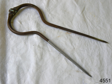
Dividers are used by navigators to measure the distance between two points on a map or chart. Each point of the divider is places on a map point, then the distance between the points of the divider is measured against the scale of the chart or map. This helps determine the ship's path of travel, the distance travelled and the current location.Not very significant as not associated with any historical event or person, same pattern of dividers is available today from many retail outlets. Also item was probably made around 1940s to 1950sDividers; brass navigator's dividers with fine, stainless steel points. Made in Britain by W & H C (inscription). This navigational tool is used by a ship's navigator to mark the ship's position. Each end point of the divider is placed on a position on a chart or map, then the length between the points of the divider is measured on the chart's scale.Inscribed "British Made" and "W & H C". flagstaff hill, warrnambool, shipwrecked-coast, flagstaff-hill, flagstaff-hill-maritime-museum, maritime-museum, shipwreck-coast, flagstaff-hill-maritime-village, navigational dividers, navigational tool, dividers made by w & hc, w & hc britain -
 Royal Australian and New Zealand College of Obstetricians & Gynaecologists (RANZCOG)
Equipment - Optometer associated with Dr Felix Meyer
This is one of a collection of items associated with Dr Felix Henry Meyer (1858-1937). Meyer was a very prominent early obstetrician and doctor, playing a part in the establishment of the role of the chair of obstetrics at the University of Melbourne in 1929. He was also a foundation member of the Royal Australian College of Surgeons.Metal optometer. Consists of a glass lens, metal scale and a sliding sight test plate. The words 'CONVEX' and 'CONCAVE' are engraved on the side of the scale. Top of the scale is engraved with various measurements. Test plate is engraved with the words 'COUNT THE DOTS' and a series of dots.optometry -
 Ballarat Clarendon College
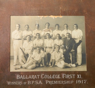
Photograph, 1917 Ballarat College First XI Winners of B.P.S.A. Premiership 1917
Gray-scale photograph, plywood mount, oversizePrinted on mount: BALLARAT COLLEGE, FIRST XI / WINNERS OF B.P.S.A. PREMIERSHIP 1917 -
 Ballarat Clarendon College
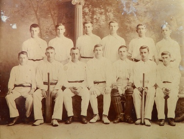
Photograph, c1900 Ballarat College Cricket
Gray-scale photograph, plywood mount, oversize -
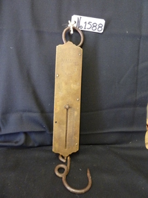
 Flagstaff Hill Maritime Museum and Village
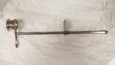
Equipment - Balance Spring Scale, Peck, Stow & Wilcox, 1890-1910
Peck, Stow & Wilcox was founded in 1870 by the merger of three different industrial tool manufacturers specializing in tin-processing equipment. Their factory complex was at 217 Centre Street in Southington, Connecticut. The company grew rapidly, and was by 1890 producing a diversified array of tools. It was also the town's largest employer. The plant was substantially enlarged in 1912, which is the period when most of the buildings surviving in 1989 were built. By that time, the complex was operated by Ideal Forging. That company went bankrupt in 2003, and the plant was acquired by real estate developers not long afterwards. Demolition of the premises took place in 2015, after hazardous materials were removed from the site.A large American company that exported it’s goods all over the world and was a major producer of balance scales. The company no longer in existence and its products are now regarded as collectors items. The subject item in the Flagstaff Hill collection is significant as the pocket spring balance scale is one of the earliest produced.Spring Balance Scale Weighs 0 to 25LBS.Stamped PS&W. Has a five pointed star stamped on front.flagstaff hill, warrnambool, flagstaff-hill-maritime-museum, maritime-museum, shipwreck-coast, flagstaff-hill-maritime-village, spring balance scales, peck stow & wilcox, pocket balance scale, weighing scales -
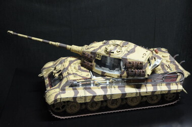 Running Rabbits Military Museum operated by the Upwey Belgrave RSL Sub Branch
German King Tiger Tank
Has internal lighting.1/15 scale. Painting by Azrael Ravenmodel, ww2, army -
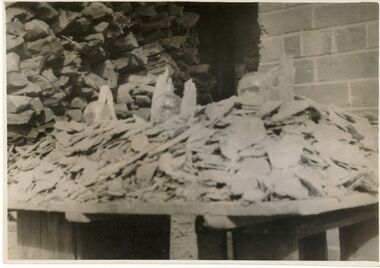 Bendigo Historical Society Inc.
Photograph - BILL ASHMAN COLLECTION: SCALEBUOY PHOTO
Black and white photograph showing scalbuoys and scale.photograph -
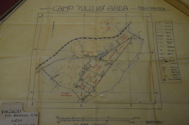 Wangaratta RSL Sub Branch
Work on paper - Field Sketch, Camp Kilo 89 Area
Hand sketch of 'Kilo 89' Camp in Palestine located in collection of assorted Army issued books and personal papers belonging to Private Alfred William VONARX VX29295 who was born 5/7/1901 at Docker Plains near Wangaratta. He enlisted on the 4/7/1940 at Seymour and served with the 2/7th Battalion in the Middle East during WW2. Written on back of sketch is - Pte B G HOY - Brian Goodwin HOY VX44031 born 20/4/1915 at Alphington.Detailed field sketch to scale of Camp Kilo 89 Area, Gaza Ridge in PalestineDetailed sketch to scale on cream coloured parchmentCamp Kilo 89 Area - Field Sketch Handwritten on rear - Pte B G HOYcamp kilo 89, palestine, ww2, alfred william vonarx, brian goodwin hoy, 2/7 infantry battalion -
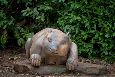 Hepburn Shire Council Art and Heritage Collection
Public Art Work, 'Wombat' - Miriam Porter. 2013, 2012 - 2013
Commissioned by the Friends of Wombat Hill Botanical Gardens and gifted to the Hepburn Shire in 2012. Historical Significance - In 1848, Irish immigrant John Egan took up land on the future town site then known as Wombat Flat. He and a party of searchers found alluvial gold in 1851 on ground now covered by Lake Daylesford initiating the local gold rush. Other finds quickly followed. With the finding of alluvial gold a town site was surveyed and founded in 1852. Initially called Wombat, it was renamed Daylesford. Cultural and Artistic Significance - Miriam Porter's 'Wombat' is a symbol of the Wombat Hill Botanical Gardens where visitors and locals alike love being photographed. Large scale solid redgum wombat sculpture.Artist intends to sign the work with 'M' on one leg.daylesford, hepburn shire, public art, miriam porter, wombat, art, sculpture, red gum, australian wood, australia, tourist attraction -
 Stawell Historical Society Inc
Memorabilia - Realia, c1940's
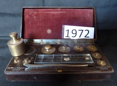
Set of Scale Weights in small Bakelite Boxstawell -
Clunes Museum
Map, Oct-74
MAP OF CLUNES STREETS/TOWNSHIP - SCALE IN CHAINSlocal history, document, maps, maps -
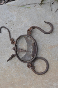
 Bendigo Historical Society Inc.
Tool - GOLD SCALES
Beam scales for weighing gold, copper dishes.weighing, weights & measures, scales -
Queenscliffe Maritime Museum
Leisure object - Model Schooner Rip, unknown
Scale model of pilot service schooner Riprip, pilot schooner -
 Kew Historical Society Inc
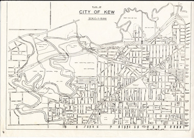
Plan, City of Kew, 1979
Plan of the City of Kew produced for public distributionPlan of City of Kew - Scale 1 : 15000Revised June 1979plans - city of kew (vic.), maps - kew (vic.), local government area - kew - victoria, cartography -
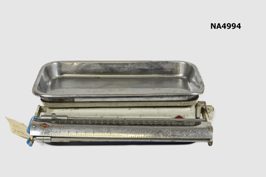
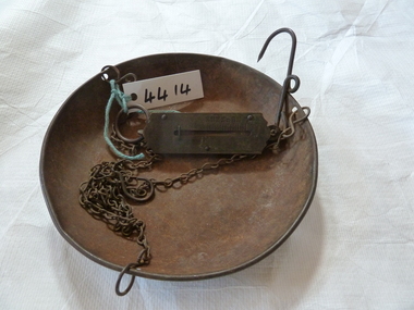 Stawell Historical Society Inc
Memorabilia - Realia, c1900's
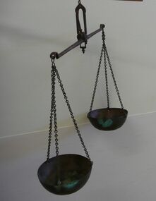
Metal Spring Scales with chain and Tray(Household)stawell