Showing 2398 items matching " structure"
-
 Falls Creek Historical Society
Letter - Chairlift Proposal
Bob (Herman) Hymans (a former member of the Royal Netherlands Navy) was born in Bloemendaal, Holland on 30th September 1922. During World War II he fought against the Japanese in the Dutch East Indies (now Indonesia) and was imprisoned in Changi and on the Burma Railway. After gaining qualifications as a Ski Instructor, Bob arrived in Falls Creek in July 1950. Working as an Instructor and Supervisor at Bogong Lodge, Bob decided his future was in accommodation. He was successful in negotiating an indenture for land from the State Electricity Commission (SEC). It took Bob two years to build his Grand Coeur Chalet but, tragically, it was burned down in August 1961. Bob also built the first Chairlift in Australia. This was a single chairlift and the structure was built from wooden electricity poles. He was constantly full of new ideas and proposals for the village. Bob Hymans died on 7th July 2007. This Collection of documents and letters tells the story of Bob's endeavours to develop Falls Creek into the ski village it is today.This item is significant because it documents proposals put forward by Bob Hymans to develop facilities in the Falls Creek Tourist Area.This letter to the Falls Creek Tourist Area Management Committee contains Mr Hymans' application to establish one or the other of two proposals at Falls Creek. Proposal A was for the installation and operation of a double Chairlift with drive station at the top as well as the establishment and operation of an observation lounge and restaurant facilities at the top station. Proposal B was for the establishment and operation of an accommodation building. In either scheme, all patrons of the restaurant would have a panoramic view of the Valley Chairlift and every skiing slope through uninterrupted glass walls. Information regarding structure details and tariffs is included. The capital expenditure was expected to exceed £220.000 for Scheme A or £45,000 for Scheme B. Mr. Hymans proposed that construction would be scheduled for completion by the commencement of the 1963 snow season.falls creek tourist area management committee, bob hymans, falls creek administration -
 Glenelg Shire Council Cultural Collection
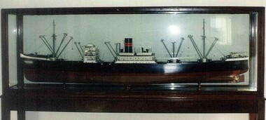
Artwork, other - Model Ship, MacKenzie and Co, Clan MacDougal Model Cargo Ship, n.d
Port of Portland CollectionModel of a ship. Hull is painted in black (above water line) and burgundy (below water line). Ship has three masts, a smoke stack (black with red stripes) and a white super structure with portholes. Supported on brass stands. Housed in a timber and glass case. Label in case.Front: T.S.M.V. Clan MacDougall Length BP 475', Breadth 64'-6", Depth 41½. Built by the Greenock Dockyard Co. Ltd. for Clanline Steamers Ltd., London.port of portland collection -
 Glenelg Shire Council Cultural Collection
Photograph, Silo construction, n.d
Port of Portland Authority ArchivesBack: September 3 in pencilport of portland -
 Kiewa Valley Historical Society
VHS Video - Kiewa, Kiewa Compile, Date compiled 25th Nov. 1998
The construction and development of the Kiewa Hydro scheme showing its construction and the people in work and play during its duration. It also shows the development of Mt Beauty and Bogong townships. The films were used as News Reels, Tourist Information and Entertainment.This item provids a snap shot in time (1990) when the Kiewa Valley was still relatively under populated and holiday houses owned by city bound workers was still relatively insignificant. As more and more holiday makers retire to a small but friendly region(Kiewa Valley and Mount Beauty) the increase in visitor numbers will affect the local rural bush scene more and more. The changes that will occur (in time) can be measured against the scenes presented in this video. The additional resources provided by the State Electricity Commission of Victoria of "alpine bush" fire control and management, together with an ongoing educational scheme for school children in learning about what constitutes the Alpine country's unique environment, are a very important offshoot, benefitting to both the communities within the Kiewa Valley and regional Victoria.This VHS tape is stored within its own plastic cover which has a front side Titled "KIEWA in the MAKING". The VHS tape is nestled within a formed inner structure which not only prevents the tape from moving to and fro but also unnecessary intrusion of foreign particles. Titled "Kiewa Compile" with 4 short films titled 1. Kiewa in the Making 2. Kiewa Capers 3. It only seems like yesterday 4. Kiewa.kiewa, hydro electricity, state electricity commission of victoria, construction towns, 1940s 1960s, mt beauty, bogong, falls creek, clover power station, mckay power station, bill sutton, news film, construction workers, early machinery -
 Bendigo Historical Society Inc.
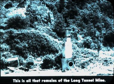
Slide - DIGGERS & MINING. DIGGERS AND MINERS, 1900s
Diggers & Mining. Diggers and Miners. This is all that remains of the Long Tunnel Mine. The photo shows a tunnel on the right of picture and possibly another in the top left corner there are 2 man made structures, the front one appears to be a chimney. Markings: 35 994.5 WAL. Used as a teaching aid.hanimounteducation, tertiary, goldfields -
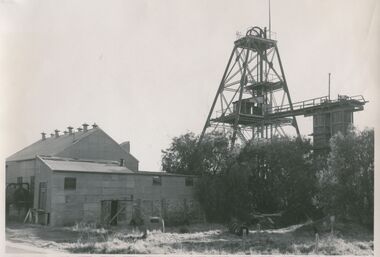 Bendigo Historical Society Inc.
Photograph - CENTRAL DEBORAH MINE, 1965 ?
black and white photograph : corrugated iron shed at left, poppet legs at right and associated structures. Trees at right foreground, car body, metal cylinders on ground in foreground. On back' Hand written in ball point pen ' Central Deborah, A. Richardson, 29 Harrison. St., Bendigo.A. Doneyorganization, business, central deborah gold mine -
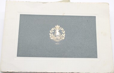 National Vietnam Veterans Museum (NVVM)
Card - Christmas card
Christmas card supplied by 8 RAR for soldiers to send to family and friends.Christmas card with RAR V111 in gold embossed with Australian emblem on grey textured paper mounted on cream colored card. Inside there is a picture of the RAR emblem on white brick structure in front of a building. Hand written message to family in blue ink. Black ink message for Christmas.Blue ink "To mum, Dad, Robyn and Rex / Bill Black type " Best Wishes for Christmas and the New Year from" / 8th Battalion, the Royal Australian Regiment.rar issue, maschette, 8rar, private, 5716538, christmas card, 8 rar, correspondence -
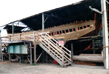 Hume City Civic Collection
Photograph, c 1989-1990
A set of 12 photographs of the 'Enterprize Project' showing the different stages of the rebuilding of the historic schooner 'Enterprize' which brought early setters to Victoria from Tasmania in 1834. George Evans who settled in Sunbury was one of the schooner passengers.A coloured photograph of the early stages in the reconstruction of the schooner 'Enterprize'. The ribs of the hull are exposed and some of the boards around the sides of the hull have been fitted. The structure is on a raised scaffold under an open shed. A painted sign 'Enterprize Project' shows details of the project is under a wooden stairway.schnooner 'enterprize', evans, irene, south wharf - melbourne, enterprize project, shire of bulla, george evans collection -
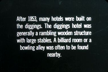 Bendigo Historical Society Inc.
Slide - DIGGERS & MINING. STORES AT THE DIGGINGS, c1853
Diggers & Mining. Stores at the diggings. After 1853, many hotels were built on the diggings. The diggings hotel was generally a rambling wooden structure with large stables. A billiard room or a bowling alley was often to be found nearby. Markings: 42 994.LIF. 5. Used as a teaching aid.hanimounteducation, tertiary, goldfields -
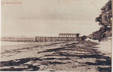 Phillip Island and District Historical Society Inc.
Photograph, Cowes Sea Baths, Phillip Island
Sea Baths at Cowes built 1893. Wooden structures extending into water. Much seaweed on sand, Moonah tree and scrub to right of photograph.The baths seafront, CowesThe Baths, Cowes. Black and Whitelocal history, photographs, sea baths, cowes, sepia photograph, mary karney -
 Eltham District Historical Society Inc
Photograph, Eltham, February 1968, Feb 1968
Location and significance not yet identified for this structure which was part of the series of 48 photos taken along Main Road, Eltham in February 1968In February 1968 an unknown person took a series of photos from the Eltham Hotel at Pitt Street heading north along Main Road through the shopping centre to just north of Elsa Court covering the length of the section of Main Road which was duplicated shortly thereafter. Shows the condition and environment of the streesscape of Main Road, Eltham immediately prior to the duplication between Pitt Street and Elsa Court through the shopping centre. Also shows a number of shops and businesses that operated at that time.Black and white photographduplication, eltham, main road -
 Port Melbourne Historical & Preservation Society
Photograph - Graham Street Methodist Church & Hall Port Melbourne, Reverend Donald LANGFORD, c.1970
To replace an earlier wooden structure, in 1860 the foundation stone of the Graham Street Methodist Church was laid by Sandridge's local member, William NICHOLSON.B & W photograph of Graham Street Methodist Church and Hall.built environment - demolition, religion - methodist church graham street, william nicholson -
Tatura Irrigation & Wartime Camps Museum
Book, Life and Times of A E Castles, 2001
Book contains details of buildings, structures and renewed interest in A E Castles as engineer and architect of Deakin Shire and events of 100 years ago.White cover, blue and black lettering. Copy of Kyabram Hotel on front cover, group of men under verandah.a e castles, deakin shire buildings, a e castles engineer, a e castles architect -
 Federation University Art Collection
Artwork, Iain Reid, 'Documentary Pathway' by Iain Reid, 1993
'Document Pathway' was commissioned for the entrance of the new Administration Building at Mount Helen. The University of Ballarat was renamed Federation University Australia on 01 January 2014. This item is part of the Federation University Art Collection. The Art Collection features over 1000 works and was listed as a 'Ballarat Treasure' in 2007.In 1993 Iain Reid wrote: "Document Pathway" Celebrating the presence of the University of Ballarat. The composition based on the proportions of a document. The document serves as a vehicle transmitting knowledge. Boarders of the document contain a structured pathway. It is solid in its base and growing aspiring to new levels and understanding. Marks on teh painting reflect an interest in Chaos theory. Through research random order is understood via measured knowledge. Surrounding the inner document lays the resource. A world to explore and enhance through knowledge. The surface of the painting investigates the aerial landscape placing the University of Ballarat within a physical location. The geometric structure demonstrating a peopled landscape where ideas create form. art, artwork, iain reid -
 Halls Gap & Grampians Historical Society
Photograph - B/W, C 1880
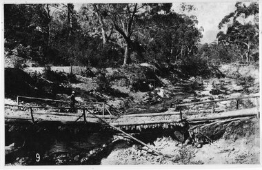
This photo shows the first Delley's Bridge, built to cross the Fyans Creek to provide access to Halls Gap and beyond in the 1880's. The bridge was swept away a number of times in floods. This bridge was replaced by a higher timber structure but constant erosion of the creek bank eventually led to its replacement by a timber and concrete structure. After nearly 50 years of its use, wear and tear necessitated a fourth bridge to be erected in 2001.A log bridge across a creek with a man standing on the bridge. A woman in a white dress and hat is beside the creek and a man is standing near her on the bank. In the left background a house can just be seen through the trees.structures, bridges -
Glenelg Shire Council Cultural Collection
Photograph - Photograph - six contact prints of silo construction, 1964
Port of Portland Authority ArchivesSheet of (6) black and white contact prints relating to Silo Construction. First and fourth photo's are of the corner KS Anderson Wharf and some construction equipment. Second and third metal tower being constructed. Fifth shed on KS Anderson. Sixth photo completed structure of metal tower.Front: 2. 28-2-64 3. 28-2-64 4. 10-3-64 5. 5-3-64 6. 5-3-64 7. 10-3-64 (Under each of the prints, in white.)port of portland archives, construction, silo, k s anderson wharf -
 Victoria Police Museum
Photograph (Victoria Police), Police Force group photo, 1920s
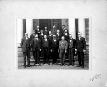
Black and white photograph mounted on bege frame. 16 men pose in 3 row structure for photograph on front of building with stairs and large columns. They are all in formal suits, most with waistcoat chains - some with freemasonry insignia. Man on the front right is holding a funny looking wood stick.Stamp on front of frame: Bartlett Bros // Bendigovictoria police museum, police officers, police force, bendigo, bartlett bros photograph, free masons, freemasonry -
 City of Moorabbin Historical Society (Operating the Box Cottage Museum)
Functional object - Kitchen Equipment, Coolgardie Safe, c1900
The invention of the Coolgardie Safe is credited to Arthur Patrick McCormick, a contractor in Coolgardie, and later the Mayor of Narrogin. Coolgardie is in the Eastern Goldfields region of Western Australia. Gold was first discovered there in 1892; the townsite became a municipality in 1894, and by 1898 its population of 15,000 made it the third largest town in Western Australia after Perth and Fremantle. In the last decade of the 19th century, Coolgardie was the capital of the West Australian goldfields. Being 180 kilometres from the nearest civilisation, food supplies were initially scarce and expensive. As fresh food was a valuable commodity there was incentive to preserve it, and keep it out of reach of scavengers such as birds, dingos, dogs, ants, and flies. It was in an effort to do this, in the extreme heat of the Australian Interior, that McCormick came up with his design for the Coolgardie Safe. McCormick noticed that a wet bag placed over a bottle cooled its contents. He further noted that if this bottle was placed in a breeze, the bag would dry out more quickly, but the bottle would get colder. What McCormick had discovered was the principle of evaporation: ‘to change any liquid into a gaseous state requires energy. This energy is taken in the form of heat from its surroundings.’ Employing this principle, McCormick made a box for his provisions which he covered with a wet hessian bag. He then placed a tray on top, into which he poured water twice daily. He hung strips of flannel from the tray so that water would drip down onto the hessian bag, keeping it damp. As the water evaporated, the heat dissipated, keeping the food stored inside cool and fresh. The success of McCormick’s invention would not have worked without a steady supply of water. Fresh water was scarce in the eastern goldfields at this time but the demand for water from a steadily growing population encouraged innovation. The solution was to condense salt water. Heating salt water in tanks produced steam that was condensed in tall cylinders, cooled and then collected in catchment trays. By 1898 there were six companies supplying condensed water to the goldfields, the largest company producing 100,000 gallons of water a day. In the early 20th century, Coolgardie Safes were also manufactured commercially. These safes incorporated shelving and a door, had metal or wooden frames and hessian bodies. The feet of the safe were usually placed in a tray of water to keep ants away. (MAV website) The early settlers of Moorabbin Shire depended on this type of Food Safe to protect their food from flies and vermin as they established market gardens in the fertile area around the notorious Elster Creek A metal framed, 4 sided structure standing on 4 legs with 2 hinged doors on one side, a metal tray at base of food safe and a metal cover over top. Ridges on which to rest trays carrying food are inside safe. The Safe is enclosed by fly-wire mesh.'...IN.....GEELONG' A manufacturer's oval metal plate is embossed on one side of Safe but it is illegible.elster creek, moorabbin, brighton, dendy's special survey 1841, market gardens, infant mortality, disease, cemeteries, fruit, vegetables, pioneers, coolgardie safe, mccormick arthur patrick, dendy henry, vaccination, jones martha, jones ethel may -
 Bendigo Historical Society Inc.
Document - ''IT SLOWLY FADES AWAY'': INFORMATION OF MICHELSEN FAMILY /THUNDERS BREWERY/LUCAN STREET BREWERY
Two page document: ''It slowly fades away - information re Michelsen family /Thunders Brewery/Lucan Street Brewery (two copies - one with pencilled-in additions/corrections. Information re the property at 46 Lucan Street and description of structure and gardens etc. Author? Date mentioned is 1973.person, individual, michelsen family, thunders brewery, lucan street brewery, bendigo cognac distillery -
Tatura Irrigation & Wartime Camps Museum
Folder, Bob Scheffer, Sketches of Irrigation Channels and Structures
Red Jacket. Black Binder. Plastic Sleeves. Pencil sketches - several coloured. 2 Fishing sotries. - one story 1 1/2 a4 typed pages, one 2 a4 pages. Structures are of early wooden era. One sketch of "Karlsrune" Lancaster. 23 Pages.irrigation, channel, drop bar -
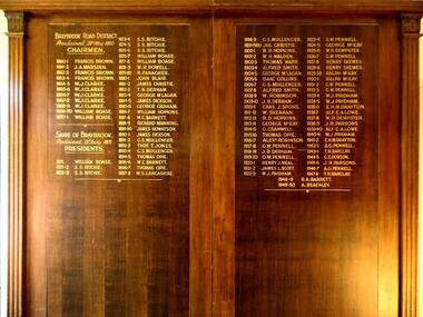 Sunshine and District Historical Society Incorporated
Honour Board, CHAIRMEN of BRAYBROOK ROAD DISTRICT 1860-1871 and PRESIDENTS of SHIRE OF BRAYBROOK 1871-1950, Unveiled 15 March 1940
By around circa 1850 Braybrook was already well established, and during the gold rush period also became a staging point for prospectors on their way to the diggings. Local government for the area began on 28th May 1860 when the BRAYBROOK ROAD BOARD DISTRICT was proclaimed, however this authority was soon superseded on 23rd January 1871 when the SHIRE OF BRAYBROOK came into existence. The Shire of Braybrook continued as the local government authority for the district until the CITY OF SUNSHINE was proclaimed in 1951. This Honour Board was unveiled on Monday 18th March 1940 at 8:30 p.m., and was hung in the Council Chamber, at the Shire of Braybrook Hall, Sunshine.The Honour Board is a historical record of the people who served as heads of local government in the district from 1860 to 1950.Large brown stained wooden structure comprised of two board sections positioned side by side to make one display board. Contains in gold coloured lettering the names of people who served as CHAIRMEN of the BRAYBROOK ROAD DISTRICT and as PRESIDENTS of the SHIRE OF BRAYBROOK during the years 1860 to 1950.braybrook road district, shire of braybrook, chairmen, presidents, 28 may 1860, 23 january 1871, 1950, sunshine., braybrook road district, shire of braybrook, chairmen, presidents, 28 may 1860, 23 january 1871, 1950, sunshine. -
Whitehorse Historical Society Inc.
Article, Tip top view of the city, 1994
Opening of the observation tower at old tip site.Opening of the observation tower at old tip site. Nunawading Apex Club joined forces with neighbouring clubs to construct it. The State Government and Nunawading Council have funded the project and Apex Club members have donated 2000 hours work over the last two years to complete the structure.Opening of the observation tower at old tip site.service clubs, nunawading apex club, secker, geoff, victorian government, city of nunawading, reeves, paul, waste transfer station, vermont south -
 Circa Vintage Archive
Cotton print bikini, Early 1960s
Bikini swimsuit with structured bust cups, straps and elastic back. Boning to the bust. Bottoms are short style, high-waisted with piping and a small bow at the front. Centre back metal zipper and button to secure. No stretch to the waistband of the shorts, although the elastic at the back of the top will allow for a bigger bust.Unlabelled. -
 Kew Historical Society Inc
Photograph - Deep Rock Swimming Pool and Clubrooms on the Yarra, c.1925
The former Deep Rock Swimming Pool was about 500 yards [457 metres] above Dight’s Falls. It was there that the Deep Rock Swimming Club was established in 1906. This initial club was expanded in 1916 to incorporate a life-saving club. In 1918, John Wren, the president of the club offered the club £1000, and undertook to sponsor a patriotic carnival in March 1918, at which swimming champions would take part. The ‘pool’ was to achieve fame as the venue for a world record-breaking ‘swallow dive’ of 205 feet 9 inches [63 metres] by ‘Prince Wickyama’, [aka Alec Wickham], a Solomon Islander. The dive from a special platform on the west side of the Yarra was reputedly viewed by between 50,000-100,000 spectators, with funds going to the State War Council. The Herald, 25 March 1918, claimed that the wide area occupied by spectators made more precise estimates impossible. In the 1980s, the construction of the Eastern Freeway, and the consequent re-routing of the Yarra River led to the site of the Deep Rock Pool being obliterated. A small cairn and plaque on the Fairfield side of the river now marks its former site.Very rare early photograph off the Deep Rock swimming pool. The pool and its built structures are historically and socially important to the people of Collingwood, Fairfield and Kew. Small, faded, Gelatin Silver print positive photograph of the Deep Rock Swimming Pool situated on the Yarra at Collingwood and Fairfield. The famous diving tower is at the right of the photo. The built structures were constructed for the Deep Rock Swimming and Life Saving Club. People are sitting on the terraces above the river. "Bathing Club. Deep Rock on the Yarra. Studley Park Melbourne. Please credit E.J. Thomasson Collection"deep rock swimming pool, deep rock swimming club, deep rock lifesaving club, swimming -- river yarra, river yarra -
 Lakes Entrance Historical Society
Photograph - The Entrance
photograph showing entrance from ocean - Bass Strait into Gippsland Lakes , western pier on left side shows timber structure , tramline and crane . North end of eastern pier on right shows workshed and travelling crane and rubble wall. Mt Barkley in background Lakes Entrance Victoriawaterways, boats and boating, piers, topography -
Villa Alba Museum
Document, Andrew Thorn, Villa Alba: Condition Survey and Stabilization of Critical Surfaces, 1997
This report was commissioned by the Villa Alba Preservation Committee following evidence of deterioration on a number of important surfaces at Villa Alba. The report documents changes that have occurred and compares them to the situation reported on in 1986. The report then outlines treatments carried out in 1986 and recently for each of the rooms worked on in 1986.36-page conservation report conducted by Andrew Thorn (Artcare) in 1997 of surfaces in Villa Alba. The report has the following structure: Condition Survey, Treatment Materials and Methods, Detailed Work in Each Room. This copy of the draft report includes detailed plans showing areas requiring stabilization.This report was commissioned by the Villa Alba Preservation Committee following evidence of deterioration on a number of important surfaces at Villa Alba. The report documents changes that have occurred and compares them to the situation reported on in 1986. The report then outlines treatments carried out in 1986 and recently for each of the rooms worked on in 1986. villa alba museum, conservation reports, andrew thorn, artcare, conservation treatments -
 Glenelg Shire Council Cultural Collection
Mixed media - Framed Art Work, Wallace, Carmel et al, Lagoon Page 5, 2004
© Anna Lanyon , Carmel Wallace 2004. Apart from any fair dealing for the purposes of private study, research, criticism or review permitted under the Copyright Act, no text, image or part thereof may be reproduced, stored in a retrieval system, or transmitted in any form, without prior written permission from the authors.This suite of etchings explores the natural and social history of Fawthrop Lagoon, an ancient intertidal lagoon that lies at the heart of Portland on the far south-west coast of Victoria, Australia. The work records and interprets essential moments in the life of the lagoon, the plants, birds, insects, water-creatures and humans who have lived and continue to live around its shores. White card backing with white torn looking inner frame. Centre is print in the colours red and green with the word '21-ST' stamped into the print. Looks like reeds and grass in the green section and a photograph of a pillar concrete type structure with the words 'EVASSER FITTED' stamped into the leg lengthways.A/P 'Lagoon' P5 Carmel Wallacefawthrop lagoon, portland, victoria, australia, plants, birds, insects, water, creatures, humans -
 Federation University Historical Collection
Scientific Instument, Spectrometer, Serial No.1667
This item was used at the Ballarat School of Mines.It had applications in teaching physics and chemistry - obtaining information about the atomic structure of the light-emitting substance.Spectrometer in wooden case. An optical instrument that employs a monochromatic light source, a prism (missing) and viewing lenses.Serial number: 1667 Manufacturer's and Supplier's namesscientific instrument, ballarat school of mines, labororatory, physics, optical measurement, chemistry, structure of substance -
Moorabbin Air Museum
Document (Item) - Mirage - New Wings
Description: Publisher: Avions Mercel Dessenlt - Breguel Aviation Pages: 50 Keywords: Mirage III 06 - Wing Structure Level of Importance: National. Marcel Dassault -
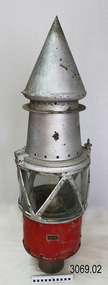 Flagstaff Hill Maritime Museum and Village
Functional object - Marine Navigation Light, Early 20th century
Breakwater navigation lights are placed at the end of the breakwaters to warn incoming vessels of the end of the structure, as a marine safety measure. The subject item was such a light believed to have been placed at the end of Warrnambool's breakwater around 1915 when it was extended. The light had remained in place for many years until it was probably removed when the structure was undergoing rock armouring repairs to the end of the breakwater in 1975. The light had been placed in a council storage shed probably from the time when the structure was undergoing these repairs in 1975. In 2014 the light was removed from the storage shed and donated to Flagstaff Hill museum. History: Warrnambool breakwater plans were drawn up by 1874 and approval was given for preliminary construction work to start but when the money ran out, the works stopped. With a number of quick changes of government the “Warrnambool” breakwater project was kicked from one Victorian state government to another. Then finally in 1879, the eminent British harbour engineer Sir John Coode was asked to design a breakwater. His first design was for a 1800 feet long structure but that was scaled back to 900 feet and construction finally began in 1884. This structure was attributed in causing major siltation of Lady bay, as a consequence the breakwater was again extended in 1915. In 1975, the rock armouring at the end of the breakwater was added but by 1979 another impact study was calling for the breakwater to be removed altogether. The Heritage Council Victoria, regard the Warrnambool breakwater is of historical significance to the state as one of the most important maritime engineering projects that was undertaken in Victoria during the late nineteenth century. The light is also as part of this structure regarded as a significant item of historical interest.Marker light or navigation light. Round light stand with conical top piece (2 separate pieces). Metal base painted red, clear glass middle section enclosed by metal frame, metal cone shaped top section painted silver. Electrical wiring can be seen inside centre section. Pole that light would have been on to elevate it is missing.Has metal plate screwed onto side of base engraved "23". flagstaff hill, warrnambool, shipreck coast, flagstaff hill maritime museum, maritime museum, great ocean road, warrnambool breakwater, marker light, naviagtion light, breakwater navigation light