Showing 527 items matching "asr"
-
 Bendigo Military Museum
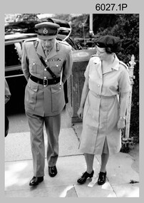
Photograph - Technical Tour of the Army Survey Regiment, 1963, c1965
These photographs were most likely taken in 1963 and c1965 on two separate occasions of an Australian Army General’s visit to the Army Survey Regiment, Fortuna, Bendigo. As there are no annotations on the photos, the exact date and the names of the Generals are unknown. Some RASvy personnel are positively identified. The technical tour included the photogrammetric and printing areas of the Regiment. The newly introduced Wild B8 stereo plotter featured in photo .2P and the M.A.N. Ultraman 3 Offset printing press probably featured in the background of photos .3P and .5P.This is a set of photographs of a visiting Australian Army General’s technical tour of the Army Survey Regiment, Bendigo. The photographs were printed on photographic paper and are part of the Army Survey Regiment’s Collection. The photographs were scanned at 300 dpi. .1) - Photo, black & white, c1965. L to R: unidentified General, CAPT Carol Castor .2) - Photo, black & white, c1965. L to R: unidentified, unidentified General, Director Survey - COL Don Macdonald AM, CO – LTCOL Frank Buckland OBE. .3) - Photo, black & white, c1965. L to R: 2LT Dennis Puniard, unidentified, unidentified General, CAPT Reg Smith, MAJ Don Ridge, WO1 Aub Harvey .4) - Photo, black & white, c1965. L to R: CAPT Reg Smith, unidentified General. .5) - Photo, black & white, 1963. L to R: WO2 Ken Rich, MAJ GEN Taylor, MAJ Bill Howarth..1 to .5 - annotated “Visit by General”royal australian survey corps, rasvy, army survey regiment, army svy regt, fortuna, asr, printing, air survey -
 Bendigo Military Museum
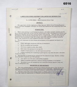
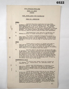
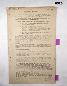
Administrative record - Royal Australian Survey Corps - A simple silk screen equipment for limited map reproduction by LTCOL HM Hall (RASvy) 1967, LtCol HM Hall (RASvy), 6 Feb 1967
This paper deals with the employment of Hand operated Mobile Screen Printing Equipment and its associated cartographic techniques for limited map reproduction and overprinting under field conditions. Written by LtCol HM Hall (RASvy)8 x A4 page document containing typed text, photos and map extractroyal australian survey corps, rasvy, fortuna, army survey regiment, army svy regt, asr, school of military survey, sms -
 Bendigo Military Museum
Administrative record - Report on Mechanism Ltd Precision Aneroid Barometer Type M1847 - WO2 Lambert (RASvy) August 1960, WO2 Lambert RASvy, August 1960
This is a Report on the Mechanism Ltd Precision Aneroid Barometer Type M1847 by WO2 Lambert (RASvy) August 1960 under the direction of the Chief Instructor at the School of Military Survey Balcombe Victoria was to determine the accuracy of the instrument for calculating heights for mapping purposes.A 6 x Foolscap sized page report that is stapled and four hole punched.. The report contains typed text, diagrams and tabular results on the fold out annex.Number "54" in top RH cornerroyal australian survey corps, rasvy, fortuna, army survey regiment, army svy regt, asr, school of military survey, balcombe -
 Bendigo Military Museum
Administrative record - Royal Australian Survey Corps - Planning for Field Survey Operations for 1:250,000 - LtCol JK Herridge (RASvy) 1960, LtCol JB Herridge (RASvy), April 1960
This 13 x page document contains notes on planning for RASvy Field Survey Operations in Northern Command during 1958 and 1959 with helicopter support available for field operations for 1:250,000 mapping. The Document was written by LtCol JB Herridge (RASvy) at the School of Military Survey Balcombe April 1960.13 x foolscap pages of typed text, stapled and four holed punchedHand written "53" in top RH cornerroyal australian survey corps, rasvy, fortuna, army survey regiment, army svy regt, asr, school of military survey, sms -
 Bendigo Military Museum
Administrative record - Trilateration with the Tellurometer - GRL Rimington 1958, Department of National Development , ACT, 26 May 1958
trilateration with the tellurometer by GRL Rimington L.S MIS (Aust) Chief Topographic Surveyor, Department of National Development, Australia. This paper was delivered to the Institute of Surveyors Conference, Brisbane 26 May 1958. This paper is a summary of Electronic distance measurements carried out in 1957 in Central Australia by officers of the division of National Mapping, Department of National Development. Trilateration is a surveying Technique that uses measurements of the sides of triangles to determine relative position.A 11 page foolscap size stapled paper report. Two holed punched with dis-coloured pages due to age.royal australian survey corps, rasvy, fortuna, army survey regiment, army svy regt, asr, division of national mapping, surveying -
 Bendigo Military Museum
Instrument - Survey Plane Table with Tripod, Circa 1910
A Plane Table consists of a smooth wooden table surface (with metal strengthening supports) mounted on a sturdy base. The base, a three-legged Tripod, is designed to support the table over a specific point on land. The connection between the tabletop and the adjustable Tripod legs permits the user to level the table precisely, using bubble levels in a horizontal plane regardless of the roughness of the terrain. The Plane Table is a surveying device used in surveying and mapping to provide a level surface on which to make drawings, charts or maps. An alidade, with or without a telescope located on the tabletop is used to sight features and draw angles to that feature. Using these lines to the same feature from different setup locations it is possible to locate that feature on the map. Plane Tabeling was widely used by the early members of the Australian Survey Corps and in both World Wars. It remains a simple and effective tool to teach the fundamentals of mapping and surveying. It was simple to use and was reasonably robust and portable. See also item 6489.2 for the Plane Table Alidade.A wooden Plane Table with alloy fittings to strengthen and support the table top. The table is fixed to a three-legged wooden Tripod with cast alloy fittings and metal pointed tips.royal australian survey corps, rasvy, fortuna, army survey regiment, army svy regt, asr, 4 fd svy sqn, school of military survey -
 Bendigo Military Museum
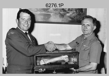
Photograph - Bones Day - Army Survey Regiment, Bendigo versus RAAF School of Radio, Laverton, 1984, 1985 and 1988
These five photographs were taken at Bones Day, an annual sports competition between the Army Survey Regiment and the RAAF School of Radio in November 1984, 1985, and 1988. The two units took turns each year to host the event. The day competition usually comprised basketball, cross country, golf, sailing, squash, softball, tennis, touch football, rifle shooting, tug-of-war and volleyball. The “big bone” trophy comprising a large bone from a beast housed inside a wooden framed glass case, was awarded to the winner of the day competition. The evening competition often included darts, carpet bowls, hookey, quoits and billiards/snooker. The “little bone” (a mounted chicken bone) was the consolation trophy awarded to the winner of the evening competition. The “O.H.A.R.A Rock” seen in photo 6276.2P was awarded to PTE Zahra for the lowest score in rifle shooting. He had to lug it with him for the rest of the evening. The 3-hour bus trip for the visiting unit on their return was typically very raucous. The history of the Bones Day competition is best described in the booklet titled - Bones of Contention Souvenir Program. 1965. Refer to Item 6267. Photo 6276.1P is also published with item 6585.41P.This collection of five photographs was taken at Bones Day, an annual sports competition between the Army Survey Regiment and the RAAF School of Radio, at Bendigo and Laverton respectively in November 1984, 1985, and 1988. The photographs were printed on photographic paper and are part of the Army Survey Regiment’s Collection. The photographs were scanned at 300 dpi. .1) - Photo, black & white, 14th November 1984, RAAF CO WGCDR McCarthy presents ‘the Big Bone’ to Army’s CO LTCOL Jorge Gruszka. .2) - Photo, black & white, 13th November 1985, Trophy presentations L to R: MAJ Daryl Hockings CSM, PTE JB Zahra, unidentified RAAF officer. .3) - Photo, black & white, 13th November 1985, tug-of-war L to R: Peter Lefel, Kerron South, Barry Hogan, DB Zahra, unidentified (x2), Guenther Ebenwaldner, Steve Burke, Mal Paterson. .4) - Photo, colour, 1988, at Bendigo, tug-of-war L to R: Jodi Bowman, unidentified, Frank Savy, Barry Hogan, unidentified (x2), Graeme Spong, unidentified (x2), Mick Duggan, unidentified, Dave Lambton-Young, unidentified (x2). .5) - Photo, colour, 1988, at Bendigo, tug-of-war L to R: Mick Duggan, Dave Lambton-Young, unidentified (x3), Frank Savy (with sign), unidentified, Barry Hogan, unidentified, Graeme Spong, unidentified (x3)..1P to .7P – No personnel are identified. The date is stamped on the back of photos .1P to .3P.royal australian survey corps, rasvy, army survey regiment, army svy regt, fortuna, asr, raaf school of radio, bones day -
 Bendigo Military Museum
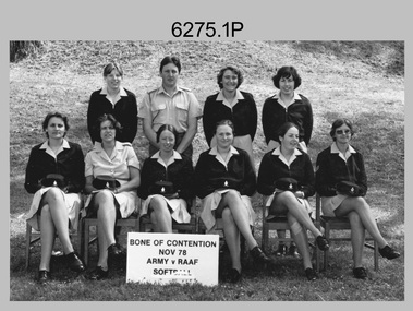
Photograph - Bones Day - Army Survey Regiment Versus RAAF School of Radio. Fortuna, Bendigo, 1978
These eight photographs were taken at Bones Day, an annual sports competition between the Army Survey Regiment and the RAAF School of Radio at Bendigo in November 1978. The two units took turns each year to host the event. The day competition usually comprised basketball, cross country, golf, sailing, squash, softball, tennis, touch football, rifle shooting, tug-of-war and volleyball. The “big bone” trophy comprising a large bone from a beast housed inside a wooden framed glass case, was awarded to the winner of the day competition. The evening competition often included darts, carpet bowls, hookey, quoits and billiards/snooker. The “little bone” (a mounted chicken bone) was the consolation trophy awarded to the winner of the evening competition. The 3-hour bus trip for the visiting unit on their return was typically very raucous. The history of the Bones Day competition is best described in the booklet titled - Bones of Contention Souvenir Program. 1965. Refer to Item 6267. See item 9001.31P for more photographs taken on this occasion.These eight photographs were taken at Bones Day, an annual sports competition between the Army Survey Regiment and the RAAF School of Radio at Bendigo in November 1978. The photographs were printed on photographic paper and are part of the Army Survey Regiment’s Collection. The photographs were scanned at 300 dpi. .1) - Photo, black & white, 1978, Softball Team Back Row L to R: Janet (Chopping) Justin, John Ashby, Scheryal Delforce, Tracey (Beckwith) Phillips. Front Row L to R: Zoe (Lisiewich) Ames, Di Chalmers, unidentified, Le-Anne (Smallshaw) Shirley, Lorraine (Daly) Talbot-Smith, Lynn Johnson. .2) - Photo, black & white, 1978, Tennis Team Back Row L to R: Mick Flynn, Chris Carter, Ken Delmenico. Front Row L to R: unidentified (x3), Adrian Rynberk. .3) - Photo, black & white, 1978, Golf Team Back Row L to R: George Austen, unidentified, Roger Rees. Front Row L to R: Peter Imeson, Greg Gilbert, unidentified officer, Paul Richards. .4) - Photo, black & white, 1978, Basketball action: Gill Park – No. 8 .5) - Photo, black & white, 1978, evening events: L to R: Garry Hudson, unidentified RAAF airwoman. .6) - Photo, black & white, 1978, evening events: L to R: Gary Warnest, Wayne Rothwell. .7) - Photo, black & white, 1978, evening events: L to R: Mick ‘Buddha’ Ellis, unidentified RAAF airwoman. .8) - Photo, black & white, 1978, evening events: L to R: Mick ‘Buddha’ Ellis, unidentified, Ian Belmont, Ken Slater. .1P to .8P – No personnel are annotated.royal australian survey corps, army svy regt, rasvy, army survey regiment, fortuna, asr, raaf school of radio, bones day -
 Bendigo Military Museum
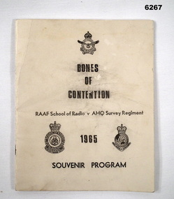
Booklet - Bones of Contention Souvenir Program 1965, RAAF School of Radio, 1965
This is the program for the annual sports competition between the RAAF School of Radio, Laverton and the AHQ Survey Regiment, Bendigo. The location of the sports day alternated annually between the two units. The day major sports trophy was the "Large Bone Trophy" and the evening minor sports trophy was the "Little Bone Trophy".Booklet, B4 size, cream covered card, title, badges of RAAF School of Radio and Royal Australian Survey Corps, 30 pages, caricatures for each sport contested. The pages have been photographed and are stored on a USB Digital Storage Device. The 30 page images have been converted into a video (.mp4) format and are also stored on the USB. The video is 2.4Mb in size and runs for 5 minutes.Forward by Wing Commander E.R. Hall, Commanding Officer RAAF School of Radio.royal australian survey corps, rasvy, fortuna, army survey regiment, army svy regt, asr, raaf, raaf school of radio, bones day -
 Bendigo Military Museum
Photograph - Map Production and Technical Services – Army Survey Regiment, Fortuna, Bendigo, July 1986
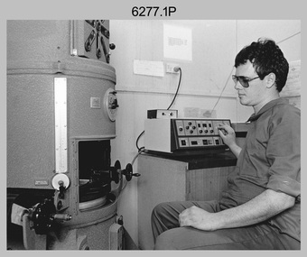
This is a collection of six photos of personnel and civilians undertaking technical tasks from Technical Services and the Air Survey, Cartographic and Lithographic Squadrons. The photos were taken at the Army Survey Regiment, Fortuna, Bendigo in July 1986. This is a set of six photographs of Army Survey Regiment personnel and civilians undertaking technical activities at Fortuna, Bendigo, in July 1986. The photographs were printed on photographic paper and are part of the Army Survey Regiment’s Collection. The photographs were scanned at 300 dpi. .1) - Photo, black & white, 1986, BARCRO work area WILD U4A Diapositive Camera, SPR Rob Jones. .2) - Photo, black & white, 1986, Aerotriangulation work area, SSGT Greg Buckingham. .3) - Photo, black & white, 1986, Technical Services in Building 16A. L to R: SSGT Andy Wilson, Tony Spurling, Pat Thwaites. .4) - Photo, black & white, 1986, RAAF Charting, L to R: SGT Paul Leskovec, SPR Toni Martin, FLT LT Don Stebbings .5) - Photo, black & white, 1986, Camera Section, CPL John Whaling. .6) - Photo, black & white, 1986, Print Troop, SPR Daryl South..1P – Annotated on back ‘JUL 86 SPR Rob Jones Barcro’ .2P – Annotated on back ‘JUL 86 SSGT Greg Buckingham Aerotrig’ .3P – Annotated on back ‘JUL 86 SSGT Andy Wilson, Mr Tony Spurling, Mr Pat Thwaites. Tech Services’ .4P – Annotated on back ‘JUL 86 SGT Paul Leskovec CSM, SPR Tony Martin, FLT LT Don Stebbings RAAF Charting’ .5P – Annotated on back ‘JUL 86 CPL John ‘Junior’ Whaling Camera Section LITHO’ .6P – Annotated on back ‘JUL 86 SPR Daryl South LITHO SQN’royal australian survey corps, rasvy, army survey regiment, army svy regt, fortuna, asr, air survey, litho, carto -
 Bendigo Military Museum
Photograph - Army Survey Regiment – Map Production, Fortuna, Bendigo, c1980s
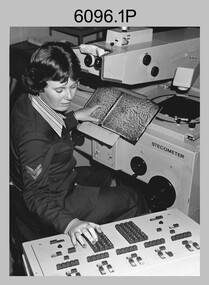
These five photographs of map production and the car park area were taken at Fortuna, Bendigo, c1980s. The first three photographs were taken in Air Survey Squadron, where aerotriangulation and digital photogrammetric extraction of topographic features from aerial photography were undertaken. Photo .4P was taken in Cartographic Squadron’s Correcting Section, located in the Attic. The technicians were probably involved in a rapid response map production, as they all were wearing field uniforms. The Army Survey Regiment’s Duty Room, RAP and Carpark appear in Photo .5P. It was probably taken from the top steps near the SGT’s accommodation block in 1986. Photos .4P and .5P are also published with item 6395.17P.This is a set of five photograph of Map Production and car park, at the Army Survey Regiment, Fortuna, Bendigo, c1980s. The photographs were printed on photographic paper and is part of the Army Survey Regiment’s Collection. Photograph .1P was scanned at 200 dpi. The others were scanned at 300 dpi. .1) - Photo, black & white, c1980s: CPL Marrianne (Van De Zee) De Groot measuring aerial photographs with a stecometer. .2) - Photo, colour, c1980s: Two unidentified technicians assessing a flight line diagram. .3) - Photo, black & white, c1980s: SPR Scheryl Delforce digitising map features on an AUTOMAP 1 Graticon table. .4) - Photo, black & white, 1986: L to R: CPL Andy Lucas, SPR Chris Gordon, unidentified, SPR Jan (Crighton) Minchin, SPR Robin Marshall, CPL Frank Downie, SPR Gayle Humphrey, unidentified technicians in the Attic, Fortuna. .5) - Photo, black & white, 1986: Army Survey Regiment Duty Room, RAP and Carpark at Fortuna. .1P - Annotated on back ‘Maryanne Degroot’ .2P, .4P to .5P – no annotation .3P - Annotated on back ‘Scheryl Delforce’royal australian survey corps, rasvy, army survey regiment, army svy regt, fortuna, asr, air survey, carto, aerotrig -
 Bendigo Military Museum
Photograph - Army Survey Regiment’s Officers, Warrant Officers and Sergeants and Squadrons, at Fortuna, Bendigo, 1982
This is a set of six staff photographs of the Army Survey Regiment’s Officers, Warrant Officers and Sergeants, and each of its four Squadrons at Fortuna, Bendigo in December 1982. Note - Air Survey Squadron’s photo was probably taken in July 1982 as they appear in winter dress. Air Survey Squadron was responsible for aerotriangulation, photogrammetric feature extraction and the AUTOMAP 1 system. Typical tasks were flight planning the acquisition of aerial photography, pugging, mensuration and block adjustments, photogrammetric extraction of topographic features from aerial photography, digital feature editing, map compilation, operating the scanner/plotter, operating the AUTOMAP 1 system and computer programming by civilians. Cartographic Squadron was responsible for the production of the following military products: Joint Operation Graphics, small-scale RAAF Air Charts, large-scale topographic line maps and orthophotomaps. Cartographic technician tasks were scribing, compiling, retouching, masking, type setting, type stickup, terrain embossing, correcting and proving quality control. Headquarters Squadron was responsible for the planning and coordination of map production and contracts. It also performed administrative and support functions such as personnel administration, pay, finance, transportation, records, map Library, kitchens, messes and facility maintenance. It was staffed by Army personnel from RASvy, RACT, AACC, RAAOC and RAEME corps. Other supporting staff at this time included the RAAF Liaison Officer, RAN Liaison Officer and several civilians employed in administration, the Q-Store and grounds maintenance. A component of the Army Svy Regt’s cartographic map production was carried out by the Detachment, a sub-unit located at Bonegilla next to the School of Military Survey. Lithographic Squadron was responsible for the reproduction of map materials and printing of military map products. The main tasks undertaken by photographic technicians were photographic enlargements, reductions and duplication of map reproduction material and processing of aerial photography. Printing technician tasks included platemaking, offset printing, map stock despatching and proofing.This is a set of six staff photographs of the Army Survey Regiment’s Officers, Warrant Officers and Sergeants, and its four Squadrons, at Fortuna, Bendigo, 1982. The black and white photographs were printed on photographic paper and are part of the Army Survey Regiment’s Collection. The photograph was scanned at 300 dpi. No personnel are identified. No personnel are identified. .1P – Annotated on front “OFFICERS MESS DEC ’82” .2P – Annotated on back “SGTS MESS DEC ’82” .4P– Annotated on front “CARTO SQN DEC ’82” .5P– Annotated on front “HQ SQN DEC ’82”royal australian survey corps, rasvy, army survey regiment, army svy regt, fortuna, asr, air survey, carto, litho -
 Bendigo Military Museum
Photograph - RA Svy Project C4 Aerodist Operation, Eastern Arnhem Land, NT, 1967
This is a set of 30 photographs of Royal Australian Survey Corps (RA Svy) personnel from Central Comd Fd Svy Unit (Adelaide) on Aerodist survey operation - Project C4 in Eastern Arnhem Land, Northern Territory in 1967. Photos of personnel were taken either at the operations base at Numbulwar or the main base at Gove (Nhulunbuy). RA Svy conducted nineteen Aerodist operations for 12 years from 1964 to 1975. Aerodist MRC2 was a tellurometer-based system adapted for aircraft to accurately measure distances between non-intervisible ground survey stations, using the aircraft as an intermediate station. Lower order geodetic results could be achieved by survey network trilateration. The measured distances between stations formed survey networks from which each station’s latitude and longitude was computed. Aerodist MRC2 was RA Svy’s major horizontal control survey tool for mainly medium scale topographic mapping (scale 1:100,000 Class A being spatially accurate to within 50 metres) in PNG, northern NT, north-west WA, Kalimantan Barat (West) Indonesia, Sumatra Indonesia, Gulf of Carpentaria and Cape York, QLD. In 1967, the Aerodist MRC2 Master equipment was installed in the aircraft featured in this set of photos, Executive Air Services’ (Essendon VIC) Grand Aero Commander VH-EXX. It was the same aircraft type and company contracted to Division of National Mapping for Aerodist MRC2 surveys. From July to October 1967 the aircraft was attached to Central Comd Fd Svy Unit (Adelaide - Major Don Ridge) on Project C4 eastern-Arnhem Land NT, where 317 Aerodist lines measuring 17,300 line miles were successfully completed. This was the most productive Aerodist project thus far. The most common helicopter used by RA Svy up to 1972 was the civilian Bell 47G-2 and the Sioux Light Observation Helicopters (LOH), the Australian Army’s equivalent featured in this photo set. These light observation helicopters had a limiting load carrying capacity of up to about 500 pounds. By comparison, one Aerodist team including two people weighed up to 1,500 pounds. Source: Royal Australian Survey Corps – Aerodist Years 1964-1975 by Peter Jensen. This is a set of 30 photographs of Royal Australian Survey Corps (RA Svy) personnel on Aerodist survey operations in Eastern Arnhem Land, Northern Territory in 1967. The photographs are on 35mm negative film and scanned at 96 dpi. They are part of the Army Survey Regiment’s Collection. .1) to .4) - black & white, 20th August 1967, Project C4 Aerodist Operations Base - Numbulwar, NT. .5) - Photo, black & white, 1967. Probable wrecked Indonesian fishing vessel. .6) to .8) - Photo, black & white, 1967. Unidentified survey operations base, L to R: unidentified personnel. .9) - Photo, black & white, 1967. Unidentified survey operations base, unidentified soldier driving a Haflinger 4x4 Light utility vehicle. .10) - Photo, black & white, 1967. Unidentified survey operations base, L to R: unidentified technician. .11) - Unidentified technician reading two survey altimeters to compute corrections to the measured distances for atmospheric refraction and to compute the sea level distances from the slope distances aircraft to the ground stations. .12) - Photo, black & white, 1967. Unidentified survey operations base, L to R: unidentified personnel. .13) to .16) - Photo, black & white, 1967. Unidentified personnel operating remote Aerodist MRC2 ground instruments. .17) to .18) - Photo, black & white, 1967. Unknown RA Svy office location. .19) to .20) - Photo, black & white, 1967. Aerodist MRC2 Master equipment. .21) to .22) - Photo, black & white, 1967. Aero Commander VH-EXX probably at Gove, NT, Central Comd Fd Svy Unit (Adelaide) – OC Major Don Ridge. .23) to .25) - Photo, black & white, 1967. Aero Commander VH-EXX probably at Gove, NT. Unidentified personnel. .26) - Photo, black & white, 1967. Aero Commander VH-EXX probably at Gove, NT. Aerodist antenna pods are visible on the aircraft. .27) to .29) - Photo, black & white, 1967. Australian Army Sioux Light Observation Helicopter (LOH) probably at Gove, NT. .30) - Photo, black & white, 1967. Panelled U337 survey station, visible as a white cross on aerial identification photo..1P to .2P – date and location on edge of film negative. .5P to .28P – no annotations .29P - annotated in white ‘RW-JEP Gove NT’ .30P - annotated in white ‘U337 Spool No1 Jun67’royal australian survey corps, rasvy, army survey regiment, army svy regt, fortuna, asr, aerodist, surveying, central comd fd svy unit -
 Bendigo Military Museum
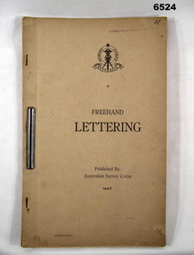
Pamphlet - Australian Survey Corps - Freehand Lettering Pamphlet 1947, Australian Survey Corps, Balcombe, 1947
All members of the Australian Survey Corps, that was later renamed the Royal Australian Survey Corps were expected to be proficient at freehand lettering and figuring. Initially all text on military maps was hand lettered in ink and an extremely high level of proficiency was required. Later technology changes meant that there was less reliance on hand lettering. This 17 x foolscap sized page booklet with light buff coloured cardboard covers held together with an ARNOS fastener was used to teach members of the Australian Survey Corps how to Hand Letter in 1947. Example practice lettering style work sheets are included at the rear of the document.17 x foolscap sized pages with light buff coloured cardboard covers held together with an ARNOS fastener. Example lettering style work sheets at the rear of the document. Cover has Australian Survey Corps Theodolite Badge in black and white above the Title "Freehand Lettering Published By Australian Survey Corps 1947.Hand-written No"11" in top RH corner. Has a stamp " E COMD FIELD SURVEY Unit"royal australian survey corps, rasvy, fortuna, army survey regiment, army svy regt, asr, school of military survey, sms, balcombe -
 Bendigo Military Museum
Administrative record - Royal Australian Survey Corps - 1st, 2nd and 3rd Order Triangulation Precis, School of Military Survey, Balcombe, Circa 1948 - 1960
A School of Military Survey Precis, 8 x foolscap sized pages of typed text, stapled and two hole punched. The precis No 3 covers the Observation procedure to be used for 1st, 2nd and 3rd Order Triangulation using the Royal Australian Survey Corps standard Cooke, Troughton and Simms Tavistock or Wild T2. The geodetic model Tavistock with a 5.25" horizontal circle should be used for 1st Order Triangulation and maybe used for 2nd Order Triangulation if specially directed. The standard Tavistock with 3.5" horizontal circle or the Wild T2 should be used for 2nd and 3rd Order observations. The Precis discusses the types of errors, the source of errors and the best ways of managing them. In surveying, triangulation is the process of determining the location of a point by measuring only angles to it from known points at either end of a fixed baseline by using trigonometry, rather than measuring distances to the point directly as in trilateration.A School of Military Survey Precis, 8 x foolscap sized pages of typed text, stapled and two hole punched.royal australian survey corps, rasvy, fortuna, army survey regiment, army svy regt, asr, school of military survey, sms, balcombe -
 Bendigo Military Museum
Administrative record - Australian Survey Corps - Survey Marks and Beacons Precis, School of Military Survey, Balcombe, Circa 1940, prior to 1948
This Australian Survey Corps School of Military Survey, Balcombe Precis has 5 x foolscap sized paper pages of typed text, stapled and is two hole punched. It was written to document the requirements for physically establishing a Permanent Australian Survey Corps Survey Ground Mark or Beacon. The Precis also discusses the different types of ground mark constructions.5 x foolscap sized paper pages of typed text, stapled and two hole punched. Paper is dis-coloured due to age.Hand written No "63" top RH cornerroyal australian survey corps, rasvy, fortuna, army survey regiment, army svy regt, asr, school of military survey, sms, balcombe -
 Bendigo Military Museum
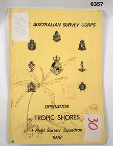
Administrative record - Royal Australian Survey Corps - Operation Tropic Shores, 1 Field Survey Squadron 1978, 31 Aug 1978
Operation Tropic Shores was conducted in 2 phases, Sep 1977 and May / Jun 78. The Operation was the field completion of Cape York 1;50,000 Mapping North of latitude 15 degrees S. Plotting was undertaken by 2, 4 and 5 Fd Svy Sqns with 1Fd Svy Sqn undertaking the mounting and Management of the field completion phase. Re-visiting and targeting of existing trig stations was also carried out as an opportunity task.Booklet, A4 cream cardboard cover, stapled Left Hand side, containing a report and plotted maps. Cover has Title and the Badges of the Australian Army Corps who participated in the Operation. 2 fd svy sqn, 4 fd svy sqn, 5 fd svy sqn, royal australian survey corps, 1 field survey squadron, 1fd svy sqn, rasvy, fortuna, army survey regiment, army svy regt, asr