Showing 734 items
matching building blocks
-
 Kew Historical Society Inc
Plan, Melbourne & Metropolitan Board of Works : Borough of Kew : Detail Plan No.1569, 1905
The Melbourne and Metropolitan Board of Works (MMBW) plans were produced from the 1890s to the 1950s. They were crucial to the design and development of Melbourne's sewerage and drainage system. The plans, at a scale of 40 feet to 1 inch (1:480), provide a detailed historical record of Melbourne streetscapes and environmental features. Each plan covers one or two street blocks (roughly six streets), showing details of buildings, including garden layouts and ownership boundaries, and features such as laneways, drains, bridges, parks, municipal boundaries and other prominent landmarks as they existed at the time each plan was produced. (Source: State Library of Victoria)This plan forms part of a large group of MMBW plans and maps that was donated to the Society by the Mr Poulter, City Engineer of the City of Kew in 1989. Within this collection, thirty-five hand-coloured plans, backed with linen, are of statewide significance as they include annotations that provide details of construction materials used in buildings in the first decade of the 20th century as well as additional information about land ownership and usage. The copies in the Public Record Office Victoria and the State Library of Victoria are monochrome versions which do not denote building materials so that the maps in this collection are invaluable and unique tools for researchers and heritage consultants. A number of the plans are not held in the collection of the State Library of Victoria so they have the additional attribute of rarity.Original survey plan, issued by the MMBW to a contractor with responsibility for constructing sewers in the area identified on the plan within the Borough of Kew. The plan was at some stage hand-coloured, possibly by the contractor, but more likely by officers working in the Engineering Department of the Borough and later Town, then City of Kew. The hand-coloured sections of buildings on the plan were used to denote masonry or brick constructions (pink), weatherboard constructions (yellow), and public buildings (grey). This plan covers parts of Sackville Street, John Street, Thomas Street and Cotham Road, and includes several very large houses in Sackville Street. Job Smith built ‘Berrington’ in about 1888-90 for himself, and ‘Pomeroy’ (now ‘Merridale’) in 1885 for James Mickleburgh. ‘Heathfield’ was built in 1888 for Henry Eeles, and was one of many fine homes in Kew, Hawthorn and surrounding suburbs designed by prolific architect John Beswicke; it later became “La Verna” and was a Franciscan monastery. Similarly, in Cotham Road, we can see ‘Bella Vista’ (now demolished), and ‘Charleville’, with its double-storeyed arcade frontage, built in 1889 for Charles Donaldson whose family occupied it until 1939. This was renamed ‘Ross House’ by the second owner, Dr. Thomas King, and then substantially restored in the 1960s by the Stillwell family, well known as car drivers and dealers. Bella Vista (later ‘Malinda’) was originally designed by the architect Robert Haddon and built for Abel Hoadley, inventor of the Violet Crumble Bar and many other delicious delicacies. He began by manufacturing jams and pickles in South Melbourne using fruit from his own orchard in East Burwood.melbourne and metropolitan board of works, detail plans, mmbw 1569, cartography -
 Kew Historical Society Inc
Plan, Melbourne & Metropolitan Board of Works : Borough of Kew : Detail Plan No.1570, 1905
The Melbourne and Metropolitan Board of Works (MMBW) plans were produced from the 1890s to the 1950s. They were crucial to the design and development of Melbourne's sewerage and drainage system. The plans, at a scale of 40 feet to 1 inch (1:480), provide a detailed historical record of Melbourne streetscapes and environmental features. Each plan covers one or two street blocks (roughly six streets), showing details of buildings, including garden layouts and ownership boundaries, and features such as laneways, drains, bridges, parks, municipal boundaries and other prominent landmarks as they existed at the time each plan was produced. (Source: State Library of Victoria)This plan forms part of a large group of MMBW plans and maps that was donated to the Society by the Mr Poulter, City Engineer of the City of Kew in 1989. Within this collection, thirty-five hand-coloured plans, backed with linen, are of statewide significance as they include annotations that provide details of construction materials used in buildings in the first decade of the 20th century as well as additional information about land ownership and usage. The copies in the Public Record Office Victoria and the State Library of Victoria are monochrome versions which do not denote building materials so that the maps in this collection are invaluable and unique tools for researchers and heritage consultants. A number of the plans are not held in the collection of the State Library of Victoria so they have the additional attribute of rarity.Original survey plan, issued by the MMBW to a contractor with responsibility for constructing sewers in the area identified on the plan within the Borough of Kew. The plan was at some stage hand-coloured, possibly by the contractor, but more likely by officers working in the Engineering Department of the Borough and later Town, then City of Kew. The hand-coloured sections of buildings on the plan were used to denote masonry or brick constructions (pink), weatherboard constructions (yellow), and public buildings (grey). Plan No.1570 shows the layout of gardens and houses in Sackville Street, Davis Street, Wrixon Street, and Fitzwilliam Street in 1904. While Thomas Street is included on the map, at this stage no houses had been built. The plan identifies two named houses: ‘Fairview’ and ‘Kylemore’. Fairview is more fully delineated in Plan No.1563. Kylemore is one of the few houses in Kew designed by John Beswicke. The most notable owner of Kylemore was William Whitehead, who owned the house between 1895 and 1900. In 1894, Australian newspapers reported the marriage of Whitehead’s daughter to Dr. Gerald Eugene Cussen, the brother of Sir Leo Cussen, the Supreme Court Judge. The married couple was to live at ‘Wilton’ (now the Kew RSL) from 1911-15.melbourne and metropolitan board of works, detail plans, mmbw 1570, cartography -
 Kew Historical Society Inc
Plan, Melbourne & Metropolitan Board of Works : Borough of Kew : Detail Plan No.1571, 1904
The Melbourne and Metropolitan Board of Works (MMBW) plans were produced from the 1890s to the 1950s. They were crucial to the design and development of Melbourne's sewerage and drainage system. The plans, at a scale of 40 feet to 1 inch (1:480), provide a detailed historical record of Melbourne streetscapes and environmental features. Each plan covers one or two street blocks (roughly six streets), showing details of buildings, including garden layouts and ownership boundaries, and features such as laneways, drains, bridges, parks, municipal boundaries and other prominent landmarks as they existed at the time each plan was produced. (Source: State Library of Victoria)This plan forms part of a large group of MMBW plans and maps that was donated to the Society by the Mr Poulter, City Engineer of the City of Kew in 1989. Within this collection, thirty-five hand-coloured plans, backed with linen, are of statewide significance as they include annotations that provide details of construction materials used in buildings in the first decade of the 20th century as well as additional information about land ownership and usage. The copies in the Public Record Office Victoria and the State Library of Victoria are monochrome versions which do not denote building materials so that the maps in this collection are invaluable and unique tools for researchers and heritage consultants. A number of the plans are not held in the collection of the State Library of Victoria so they have the additional attribute of rarity.Digital copy of the original survey plan, issued by the MMBW to a contractor with responsibility for constructing sewers in the area identified on the plan within the Borough of Kew. The plan was at some stage hand-coloured, possibly by the contractor, but more likely by officers working in the Engineering Department of the Borough and later Town, then City of Kew. The hand-coloured sections of buildings on the plan were used to denote masonry or brick constructions (pink), weatherboard constructions (yellow), and public buildings (grey). This plan is part of a large and historically significant group of MMBW plans and maps that was donated to the Society by the Mr Poulter, City Engineer of the City of Kew in 1989. When the contracts were let for surveyors to identify and record the extant houses and landscapes within an area for the Board of Works, the contracts were let at separate times, hence the anomaly where two copies of Plan No.1571 exist in our collection. The first of these plans identifies the building materials used in houses bordering Fitzwilliam Street, Edgevale Road, May Street, Malin Street, Davis Street and Wellington Street. The cut off point for the survey was the south side of Wellington Street. By 1903 when the survey was undertaken many of the sites were already built on, particularly those facing Edgevale Road. The plan identifies the preponderance of weatherboard houses in the area. The other version of the plan identifies the buildings between Wellington Street and Cotham Road.melbourne and metropolitan board of works, detail plans, mmbw 1571, cartography -
 Kew Historical Society Inc
Plan, Melbourne & Metropolitan Board of Works : Borough of Kew : Detail Plan No.1571, 1904
The Melbourne and Metropolitan Board of Works (MMBW) plans were produced from the 1890s to the 1950s. They were crucial to the design and development of Melbourne's sewerage and drainage system. The plans, at a scale of 40 feet to 1 inch (1:480), provide a detailed historical record of Melbourne streetscapes and environmental features. Each plan covers one or two street blocks (roughly six streets), showing details of buildings, including garden layouts and ownership boundaries, and features such as laneways, drains, bridges, parks, municipal boundaries and other prominent landmarks as they existed at the time each plan was produced. (Source: State Library of Victoria)This plan forms part of a large group of MMBW plans and maps that was donated to the Society by the Mr Poulter, City Engineer of the City of Kew in 1989. Within this collection, thirty-five hand-coloured plans, backed with linen, are of statewide significance as they include annotations that provide details of construction materials used in buildings in the first decade of the 20th century as well as additional information about land ownership and usage. The copies in the Public Record Office Victoria and the State Library of Victoria are monochrome versions which do not denote building materials so that the maps in this collection are invaluable and unique tools for researchers and heritage consultants. A number of the plans are not held in the collection of the State Library of Victoria so they have the additional attribute of rarity.Original survey plan, issued by the MMBW to a contractor with responsibility for constructing sewers in the area identified on the plan within the Borough of Kew. The plan was at some stage hand-coloured, possibly by the contractor, but more likely by officers working in the Engineering Department of the Borough and later Town, then City of Kew. The hand-coloured sections of buildings on the plan were used to denote masonry or brick constructions (pink), weatherboard constructions (yellow), and public buildings (grey). This plan is the other half of Plan No.1571 representing the constructions to the west of Wellington Street before and in 1903/4. This plan represents the built environment in Edgevale Road, Wellington Street, Atkins Street, Annadale Street, Mortimer Street, and Cotham Road. Whereas there are smaller allotments and more modest housing stock facing Edgevale Road, larger blocks and more substantial houses are represented facing Cotham Road.melbourne and metropolitan board of works, detail plans, mmbw 1571, cartography -
 Kew Historical Society Inc
Plan, Melbourne & Metropolitan Board of Works : Borough of Kew : Detail Plan No.1572, 1905
The Melbourne and Metropolitan Board of Works (MMBW) plans were produced from the 1890s to the 1950s. They were crucial to the design and development of Melbourne's sewerage and drainage system. The plans, at a scale of 40 feet to 1 inch (1:480), provide a detailed historical record of Melbourne streetscapes and environmental features. Each plan covers one or two street blocks (roughly six streets), showing details of buildings, including garden layouts and ownership boundaries, and features such as laneways, drains, bridges, parks, municipal boundaries and other prominent landmarks as they existed at the time each plan was produced. (Source: State Library of Victoria)This plan forms part of a large group of MMBW plans and maps that was donated to the Society by the Mr Poulter, City Engineer of the City of Kew in 1989. Within this collection, thirty-five hand-coloured plans, backed with linen, are of statewide significance as they include annotations that provide details of construction materials used in buildings in the first decade of the 20th century as well as additional information about land ownership and usage. The copies in the Public Record Office Victoria and the State Library of Victoria are monochrome versions which do not denote building materials so that the maps in this collection are invaluable and unique tools for researchers and heritage consultants. A number of the plans are not held in the collection of the State Library of Victoria so they have the additional attribute of rarity.Original survey plan, issued by the MMBW to a contractor with responsibility for constructing sewers in the area identified on the plan within the Borough of Kew. The plan was at some stage hand-coloured, possibly by the contractor, but more likely by officers working in the Engineering Department of the Borough and later Town, then City of Kew. The hand-coloured sections of buildings on the plan were used to denote masonry or brick constructions (pink), weatherboard constructions (yellow), and public buildings (grey). Plan No. 1572 represents the built environment bordered by Barkers Road, Wrixon Street, Edgevale Road and Fitzwilliam Street. Other streets identified on the plan include Stansell Street. Plan 1572 shows that by 1903-05, there was only patchy development in this area of Kew, mainly on Edgevale Road and Fitzwilliam Street. Only two named houses are identified: the quaintly named ‘Tweed Cottage’, and ‘Mendip’. The earliest reference to Treed Cottage in Australian newspapers is to the death of Walter Thompson, aged 74 who was a resident there in 1885. His youngest daughter was to die there in 1908. Mendip to the north of Tweed Cottage was owned by Henry Thompson; he was to die in 1901; his wife in 1932. At this period of time, Malin Street and Clivedon Court did not extend to Barkers Road.melbourne and metropolitan board of works, detail plans, mmbw 1572, cartography -
 Kew Historical Society Inc
Plan, Melbourne & Metropolitan Board of Works : Borough of Kew : Detail Plan No.1573, 1905
The Melbourne and Metropolitan Board of Works (MMBW) plans were produced from the 1890s to the 1950s. They were crucial to the design and development of Melbourne's sewerage and drainage system. The plans, at a scale of 40 feet to 1 inch (1:480), provide a detailed historical record of Melbourne streetscapes and environmental features. Each plan covers one or two street blocks (roughly six streets), showing details of buildings, including garden layouts and ownership boundaries, and features such as laneways, drains, bridges, parks, municipal boundaries and other prominent landmarks as they existed at the time each plan was produced. (Source: State Library of Victoria)This plan forms part of a large group of MMBW plans and maps that was donated to the Society by the Mr Poulter, City Engineer of the City of Kew in 1989. Within this collection, thirty-five hand-coloured plans, backed with linen, are of statewide significance as they include annotations that provide details of construction materials used in buildings in the first decade of the 20th century as well as additional information about land ownership and usage. The copies in the Public Record Office Victoria and the State Library of Victoria are monochrome versions which do not denote building materials so that the maps in this collection are invaluable and unique tools for researchers and heritage consultants. A number of the plans are not held in the collection of the State Library of Victoria so they have the additional attribute of rarity.Original survey plan, issued by the MMBW to a contractor with responsibility for constructing sewers in the area identified on the plan within the Borough of Kew. The plan was at some stage hand-coloured, possibly by the contractor, but more likely by officers working in the Engineering Department of the Borough and later Town, then City of Kew. The hand-coloured sections of buildings on the plan were used to denote masonry or brick constructions (pink), weatherboard constructions (yellow), and public buildings (grey). This plan has detailed annotations written in red or blue ink, showing prices, which may be the annual valuations of the properties, and some owners’ names, a most unusual feature on contractor's maps. Some areas, such as the buildings of Methodist Ladies’ College (MLC), include the school’s tennis court and swimming pool, but are not coloured to show building materials – did the draftsman just run out of time, or ink, or enthusiasm, before his plan had to be submitted? MLC had been founded in 1882 as a ‘modern school of the first order’ with buildings that formed ‘a collegiate institution for girls unsurpassed in the colonies’. The goal of its founders was to provide a high-class Christian education for girls, comparable with that provided elsewhere for boys. Some shops are shown along Edgevale Road, though they are not designated as commercial premises. Larger houses are depicted, including ‘Fairlawn’ in Barkers Road, and ‘Clevedon’ and ‘Rosehill’ (now demolished) in Fitzwilliam Street.melbourne and metropolitan board of works, detail plans, mmbw 1573, maps - borough of kew, cartography -
 Kew Historical Society Inc
Plan, Melbourne & Metropolitan Board of Works : Borough of Kew : Detail Plan No.1574, 1905
The Melbourne and Metropolitan Board of Works (MMBW) plans were produced from the 1890s to the 1950s. They were crucial to the design and development of Melbourne's sewerage and drainage system. The plans, at a scale of 40 feet to 1 inch (1:480), provide a detailed historical record of Melbourne streetscapes and environmental features. Each plan covers one or two street blocks (roughly six streets), showing details of buildings, including garden layouts and ownership boundaries, and features such as laneways, drains, bridges, parks, municipal boundaries and other prominent landmarks as they existed at the time each plan was produced. (Source: State Library of Victoria)This plan forms part of a large group of MMBW plans and maps that was donated to the Society by the Mr Poulter, City Engineer of the City of Kew in 1989. Within this collection, thirty-five hand-coloured plans, backed with linen, are of statewide significance as they include annotations that provide details of construction materials used in buildings in the first decade of the 20th century as well as additional information about land ownership and usage. The copies in the Public Record Office Victoria and the State Library of Victoria are monochrome versions which do not denote building materials so that the maps in this collection are invaluable and unique tools for researchers and heritage consultants. A number of the plans are not held in the collection of the State Library of Victoria so they have the additional attribute of rarity.Original survey plan, issued by the MMBW to a contractor with responsibility for constructing sewers in the area identified on the plan within the Borough of Kew. The plan was at some stage hand-coloured, possibly by the contractor, but more likely by officers working in the Engineering Department of the Borough and later Town, then City of Kew. The hand-coloured sections of buildings on the plan were used to denote masonry or brick constructions (pink), weatherboard constructions (yellow), and public buildings (grey). This plan shows several very large houses, particularly along Glenferrie Road, and the area now occupied by Ruyton Girls’ School. ‘Tarring’ (incorrectly spelled here as ‘Karring’) was built for Henry Henty in 1872, on part of his original allotment of 20 acres, and ‘Mount View’, which retains its original building and the fountain in the front garden, is part of Ruyton’s Junior School. The most significant change to Tarring and its grounds since 1903, involve the removal of a number of the outbuildings, including a Burmese temple, bought by Henty from the Burmese Exhibit at the Great Exhibition of 1880. It is shown on the plan as a summerhouse. The two-storey mansion, on the corner of Glenferrie Road and Wellington Street, was built in 1891 by leading architect Alfred White as his own home. Having an initial N.A.V. of £160, the house was purchased by a warehouseman Henry Lister, by 1900, when the N.A.V. was recorded at £111. By the turn of the century the house was known as ‘Comaques’. By contrast, much smaller houses are shown in Scott and Byron Streets, including a tiny Mission Hall in Byron Street, which belonged to the Anglican Church from at least 1903 to 1917.melbourne and metropolitan board of works, detail plans, maps - borough of kew, mmbw 1574, cartography -
 Kew Historical Society Inc
Plan, Melbourne & Metropolitan Board of Works : Borough of Kew : Detail Plan No.1575, 1905
The Melbourne and Metropolitan Board of Works (MMBW) plans were produced from the 1890s to the 1950s. They were crucial to the design and development of Melbourne's sewerage and drainage system. The plans, at a scale of 40 feet to 1 inch (1:480), provide a detailed historical record of Melbourne streetscapes and environmental features. Each plan covers one or two street blocks (roughly six streets), showing details of buildings, including garden layouts and ownership boundaries, and features such as laneways, drains, bridges, parks, municipal boundaries and other prominent landmarks as they existed at the time each plan was produced. (Source: State Library of Victoria)This plan forms part of a large group of MMBW plans and maps that was donated to the Society by the Mr Poulter, City Engineer of the City of Kew in 1989. Within this collection, thirty-five hand-coloured plans, backed with linen, are of statewide significance as they include annotations that provide details of construction materials used in buildings in the first decade of the 20th century as well as additional information about land ownership and usage. The copies in the Public Record Office Victoria and the State Library of Victoria are monochrome versions which do not denote building materials so that the maps in this collection are invaluable and unique tools for researchers and heritage consultants. A number of the plans are not held in the collection of the State Library of Victoria so they have the additional attribute of rarity.Original survey plan, issued by the MMBW to a contractor with responsibility for constructing sewers in the area identified on the plan within the Borough of Kew. The plan was at some stage hand-coloured, possibly by the contractor, but more likely by officers working in the Engineering Department of the Borough and later Town, then City of Kew. The hand-coloured sections of buildings on the plan were used to denote masonry or brick constructions (pink), weatherboard constructions (yellow), and public buildings (grey). Plan No.1575 shows that in the area bounded by Wellington Street, Edgevale Road, Glenferrie Road, and Cotham Road, there had already been significant subdivision of land and houses constructed. As one of the highest points in Kew, as expected, there were already some significant mansions built on large allotments of land. Many of these mansions are identified by name on the plan such as ‘Kelso’, ‘Abbotsford’, ‘Clarendon’ and ‘Ashlyn’ in Cotham Road. Other houses of equal size are unnamed on the plan.melbourne and metropolitan board of works, detail plans, maps - borough of kew, mmbw 1575, cartography -
 Kew Historical Society Inc
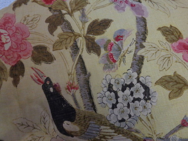
Decorative object - Paradise Bird Design Linen Curtains, GP&J Baker, 1920s
William Turner, a Scottish born free-lance designer, who was contracted to GP&J Baker, painted the image on which the design was based in 1918. Turner had trained as a furniture designer before leaving for London in the 1890s, where he rose to prominence as an Arts & Crafts designer. The bird that gives this design its name is adapted from Robert Havell’s ‘A Collection of Birds of Paradise’, published in 1835, and was a favourite of Victorian chintz designers.“Paradise Bird” has been in continuous production since its creation. The hand-block print, of which these curtains are an early example, was supplemented by a version engraved on copper rollers in 1962, and was updated onto screens in 1982. The curtains have significance to the collection because of their intrinsic value and for the link to one of the historic mansions in the City of Boroondara. The curtains by G.P & J Baker of London use one of the exemplary designs in this manufacturer’s output. The first use of the design was in 1918, following the Great War, and the design is said to reflect the hope for peace which was a feature of the postwar years. The curtains are an early example of the Paradise Bird design, and were block printed. A pair of curtains originally situated in one of the front reception rooms of 'Tourmont' in Balwyn Road, Balwyn (now Fintona Girls’ School). The fabric in the curtains was manufactured by the English firm of GP&J Baker. The textile design is variably named as ‘Paradise Bird’ or more recently, ‘Hydrangea Bird’. Turner’s bird perches in a blossoming branch directly above a woodpecker, which is an attribute of Mars, god of war. Thus the design reads as a symbolic statement where War is reversed and Paradise returns (a hopeful message at the end of WWI). “Paradise Bird” has been in continuous production since its creation. . curtains, fabric design, historic buildings -
 Kew Historical Society Inc
Leisure object - Construction Toy, Lott's Bricks Ltd, Lott's Bricks: British Made Throughout in Stone, 1945-1955
At the beginning of the 20th century the toy industry was based predominantly in Germany. During the First World War, imports from Germany were banned and the British government instead encouraged toy-making in Britain, as it helped the economy and provided jobs for ex-servicemen. Around this time, English manufacturer E. A. Lott devised a new system of bricks suitable for assembling small buildings. Together with a cardboard roof and instructions, Lott started selling these bricks as Lott’s Bricks in 1918. Lott’s Bricks eventually became even more popular then Anchor blocks, which were produced on the same principles by Richter, the well-known German manufacturer of construction toys. Lott’s success was assured when Queen Mary bought a set from him at the British Industries Fair in 1918. A number of sets were later produced, each with its own series, including Modern, Lodomo and Tudor. The bricks were the last of the old-fashioned composition blocks, which were later superseded by the very different styles exemplified by Minibrix, Bayko and Lego. Lotts Brick’s Ltd ceased to exist in the 1960s. (Source: V&A Museum)Toy with model building materials in wooden box with manufacturers label on lid. Th label pictures a white brick house with two equidistant chimneys. Included in the box are blocks to be used in building the house. These are in different shapes and sizes. The roofing panels are preformed.Manufacturer information and description lott's bricks, toy blocks, construction toys -
 Kew Historical Society Inc
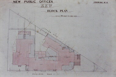
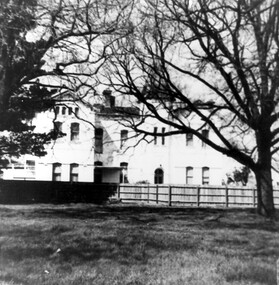
Slide - Architectural Drawing, Kew Public Offices, 1887
A civic campaign for new public offices developed in Kew in the 1880s. After much deliberation, the location chosen was the junction of Bulleen and Cotham Roads. The buildings were designed by George Watson and John Henry Harvey, architects within the Department of Public Works (Victoria). Building was commenced in 1887, and after one year, the buildings were opened. The Post Office was transferred to the new Commonwealth Government in 1901. The Police Station and Court House, sold by the Victorian Government to the City of Boroondara in 2007, are now a community cultural centre and performing arts venue.The buildings were listed on the Victorian Heritage Register Register (HO885) in 1991. They are historically and architecturally significant to the State Of Victoria because Watson and Harvey's designs exhibit diversity in integrating civil offices, they accommodate the apex of road junctions, and they demonstrate a departure from the contemporaneously favoured High Victorian Classical to the Queen Anne style in the design of civic buildings. 35mm colour transparency of an original plan by George Watson and John Henry Harvey, architects of the Department of Public Works (Victoria), in 1887 for New Public Offices at Kew. This plan was copied by the donor from an original held at the Commonwealth Archives in Brighton (Vic). The copy was made to illustrate a report that the donor made on ‘The functional planning design, building materials and construction methods of the Kew Post Office’ as part of course work at RMIT.NEW PUBLIC OFFICES KEW / BLOCK PLAN / SCALE 16 FEET TO ONE INCH / DRAWING NO 4kew court house, kew police station, kew post office, architectural drawings, khs - slides, new public offices — kew (vic.), architecture — queen anne style -
 Kew Historical Society Inc
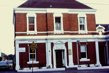
Slide - Kew Police Station, High Street, 1976
Colour transparency (slide) created in June 1976 during a tour by the Junior National Trust, which was led by members of Kew Historical Society. The collection of 21 slides reveals that the tour covered all parts of Kew, but focused understandably on heritage buildings and sites.Image of an historic place in Kew that can be dated to an exact time and place. The images, albeit amateurish in composition, frequently reveal aspects of important buildings and sites that have changed over time.35mm colour transparency of the former Kew Police Station (closed 2002) in High Street, Kew. The original structure was built as a house for the resident police sergeant and his family. Offices and a cell block were located at the rear of this building. The Queen Anne revival style employed by the Department of Public Works architects, favoured the use of red brick highlighted by stucco. The painted white stucco is not the original colour. The building is part of a suite of public offices opened in 1888.public offices -- kew (vic.), police stations -- kew (vic.) -
 Kew Historical Society Inc
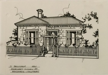
Drawing - Property Illustration, Margaret Picken, 71 Brougham Street, Kew, 1989
After training as a Cartographic Draftsman within the mining industry, I worked as a property illustrator for real estate firms in the eastern suburbs of Melbourne for 23 years from 1983. I initially photographed houses with a Polaroid camera and made a 'thumbnail' sketch while there. The photos were used to scale off a sketch in pencil and then that sketch was overlaid with drafting film and the 'pen and ink' completed. The pens I used were the Rotring ‘Rapidigraph’ drafting pens. The ink was also made by Rotring (German).The film was ‘Rapidraw’, polyester drafting film, double matte. It takes a very fine line and doesn’t bleed. As well as house sketches, there were often floor plans and site plans ordered. Aerial sketches were ordered when the property needed an overall view. (Margaret Picken, 2020)This drawing is one of a series created by Margaret Picken for a range of real estate agents in Melbourne between c.1983 and c.2005. Each work is signed and dated by the artist.Gift of Margaret Picken, 2020Property illustration of a block-fronted Victorian villa. Extant building 08/2020. The pen and ink architectural drawing on drafting film of 71 Brougham Street was made by Margaret Picken in 1989.71 BROUGHAM ST., KEW / MARGARET PICKEN '89 / WOODARDS ~ HAWTHORNartist -- margaret picken 1950-, architectural drawings -- houses -- kew (vic.), 71 brougham street -- kew (vic.) -
 Queen Victoria Women's Centre
Photograph, c.1996
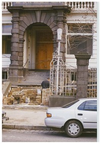
Colour photograph. From Lonsdale street looking north towards building. Front entrance, constructing access ramp and restoring stairs. 'The Queen Elizabeth Block' in gold above archway. Person in dark clothing in middle o frame. White sedan on right side of frame. Taken during restoration inspection.historic buildings, building construction -
 Queen Victoria Women's Centre
Photograph, August 1996
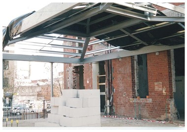
Colour photograph. Ground floor facing south towards Lonsdale street in what was to be the cafe and in 2015 is the Breacan office. Entrances show access corridors to former towers. White besser blocks in foreground. New structure for roof seen with tarp. Taken during restoration inspection.building construction, historic buildings, cultural structures and establishments -
 Queen Victoria Women's Centre
Photograph, c.1992
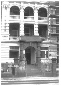
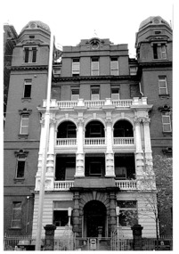
Black and white photograph. Photo of block E's facade of the Queen Victoria Memorial Hospital which was to be QVWC. Before restoration and after the hospital had moved to Clayton. Taken from Lonsdale street, scaffolding left of frame. historic buildings, hospitals, charitable organisations, cultural structures and establishments -
 Queen Victoria Women's Centre
Photograph, c.1992
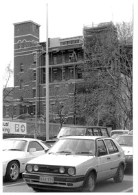
Black and white photograph. Photo o western side of block E of the Queen Victoria Memorial Hospital which was to be the QVWC before the restoration and after the hospital had moved to Clayton. From Lonsdale street with a number of cars in the foreground of photograph. Scaffolding at right of frame. historic buildings, hospitals, cultural structures and establishments -
 Queen Victoria Women's Centre
Photograph, c.1995
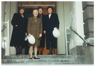
Colour photograph. On Lonsdale street and south entrance stairs of block during door of the building. Four women with hard hats face towards camera. Left to right: Minister for Arts Lorraine Elliot, Minister for Women's Affairs Jan Wade, Chair Janet England, Minister for Aboriginal Affairs Ann Henderson parliamentary representatives, historic buildings, building construction -
 Queen Victoria Women's Centre
Photograph, c.1992
Black and white photograph. Photo of whole facade of block E of the Queen Victoria Memorial Hospital. Taken from Lonsdale street. Before restoration and after the hospital had moved to Clayton.historic buildings, hospitals, cultural structures and establishments -
 Queen Victoria Women's Centre
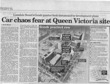
Newspaper excerpt, The Sunday Age, Car Chaos fear at Queen Victoria Site: Lonsdale Street's Greek quarter feels threatened by development plans, 29 October 2000
Newspaper excerpt from The Sunday Age. Page 5 and a smaller introduction probably from the front page. Smaller excerpt colour photo of blue-stone and cast-iron wall which was to be demolished. Larger excerpt, a black and white aerial view of QVWC and the block where it is situated. building construction, building permits, historic building -
 Queen Victoria Women's Centre
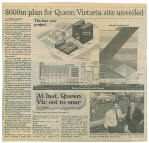
Newspaper clipping, Wayne Taylor, $600m plan for Queen Victoria site unveiled, 21 February 2001
Unveiling of the QV plans by Groconnewspaper clipping from The Age. Graphic representing the works to be done on the QV block between Swanston street and Russell street. Black and white photo at the bottom of page of Premier Steve Bracks with director of Grocon, Daniel Grollo after the plans for QV were announced. building construction, historic building, civic centres, town planning -
 Surrey Hills Historical Society Collection
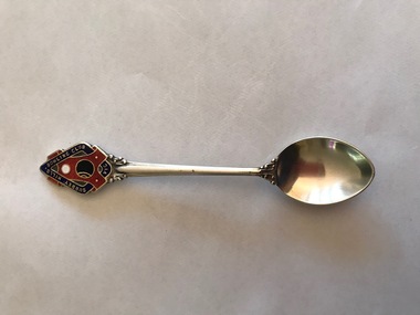
Souvenir - Souvenir teaspoon, Twentieth Century
James Albon is credited with building the first bowling green in Surrey Hills at his home on the corner of Mont Albert Road and Wilson Street (later occupied by the Roman Catholic convent). This green was so popular with his friends that he organised the formation of a bowling club at the corner of Montrose and Wilson Streets. It opened in 1912. Earliest club records date from 1916. The original club-house was rebuilt in 1922/23 using interlocking blocks as recommended by Walter Burley-Griffin. This was quite an innovative design at the time. In turn cream brick buildings replaced this building in the 1950s. The Surrey Hills Bowls Club disbanded in 1995. The donor believed that this spoon belong to her grandfather David Miller (Dave) Mair who lived at 20 Barton Street until his death in 1938. Dave was an extremely keen sportsman (particularly bowls and cricket). He started the Kangaroo Cricket Club and worked for the Melbourne Cricket Club. She initially sent the spoon to the Surrey Hills Bowling Club in 1996, not realising that it had closed the previous year. It was returned to her and over 20 years later was donated to this collection. This is part of a large donation of material relating to the Deakin, Mair and Young families, all with connections to the Surrey Hills and Mont Albert area. This augments other material relating to the history of the Surrey Hills Bowling Club that was saved by Jocelyn and Ken Hall after the club closed in 1995. The official records of the club were deposited with the State Library of Victoria, but prior to this some summary notes were made by the Halls. The material is evidence of one of the earliest sporting clubs established in the area.An EPNS metal teaspoon, consisting of a curved bowl with a decorative plaque at the top of the handle. On the front of this is an image of a lawn bowls ball and a jack within a scroll and linked with a band containing the words "SURREY HILLS BOWLING CLUB VIC". The plaque is inlaid in red, navy, white and black enamel. The makers name is impressed into the back of the handle.Rear: "Paramount" / "E.P.N.S."surrey hills bowling club, souvenir spoons, david miller mair, dave mair, laurie young, laurie newton -
 Surrey Hills Historical Society Collection
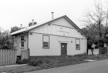
Photograph, Scout Hall at 7 Robinson Road, Surrey Hills in 1990
The Box Hill Reporter noted on 22 January 1926 that at the monthly meeting of the Surrey Hills Progress Association the Secretary reported that “the ground had been purchased for the Boy Scout Hall, that plans had been prepared, and accepted by the building committee. As soon as the timber was available the work would be proceeded with. The Boy Scout Hall movement has been taken up by the association to try to secure a permanent meeting place for the boys of the district. Up till now they have no fixed place, nor have they had a qualified scout master. Mr. Bert Chenu, one of the committee, has been appointed to that position, and is carrying out his duties energetically. Having raised enough money to purchase the land (situated in Robinson's road, Surrey-Hills near the Drill Hall) the association's committee is now about to erect the building by means of properly organised working bees.” The Association organised markets, card evenings and dances to raise necessary funds. The volunteer labour included the parents of boys who had become scouts, led by builder Robert Hayes of 186 Union Road and his son, who was also a builder. Early ownership is unclear as it is believed that it was not purchased by the scouting movement until 1955. The hall was used by other groups as well as the scouts. Benmont Kindergarten operated on the site from c1930. This is confirmed by oral testimony, Sands & McDougall entries and the Alan Hold property register (part of the SHNC Heritage Collection.) It was also used as a ballet school and for local dances. The hall was situated on a small block of land, just 410 sq m, and in late 2019 it was put up for sale by Scouts Victoria. Most recently home to 1st Boroondara Scout Group and previously 11th Camberwell Scouts, it was sold for something near $1.3M. During May 2020 the modest hall was demolished. Items of significance were removed before the sale by Scout Heritage. A black and white photograph of a building with a small sign identifying it as 11th Camberwell Central Scout Group.robinson road, surrey hills, scout halls, scouts, buildings, structures and establishments, (mr) robert hayes, union road, builders, surrey hills progress association, benmont kindergarten, dances, ballet schools -
 Surrey Hills Historical Society Collection
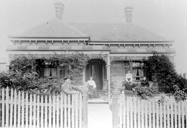
Photograph, "Braemar" 18 Suffolk Road, Surrey Hills
"Braemar" at 18 Suffolk Road, Surrey Hills - built c1894, demolished in1977 – and home of James Sneddon Snr. and family from 1890 until c1950. We believe it is James is at the gate and his family on the veranda. James was born in Alloa, Clackmannanshire Scotland in 1833, as was his wife Jane. He died in March 1901 and she in March 1911. They are buried in Boroondara Cemetery (Pres B0522) with their daughter Jane (1864-1928). James Sneddon (Snr) was an important man in early Surrey Hills. He established real estate and ironmongery businesses in Union Road – first on the corner of Stirling Crescent and later over the road on the corner of Windsor Crescent. He was chairman of Surrey Hills’ MUIOOF (Manchester Unity Independent Order of Oddfellows). James Sneddon Jnr. followed his father in the family real estate business and was an even busier community man. He was a JP and had roles in the Surrey Hills ANA, the Progress Association and the Choral Society. He lived 2 doors from his father. The real estate business continued on the corner of Windsor Crescent and Union Road (north side) until the business was sold to the Doubleday (family) after WW2.The Sneddon family were early settlers and business owners in Surrey Hills and remained over 3 generations. Different family members held many roles in community organisations. This photo is also important in documenting built heritage that has been demolished.Image of a Victorian, weatherboard, block fronted, single storey house with decorative veranda, viewed from the front. The garden in front of the house is well established and a light-coloured picket fence surrounds the property. Four people are in the photograph, three women (two seated and one standing) on the veranda and one male, who is leaning against the gate post.buildings, structures and establishments, houses, timber houses, house names, braemar, architectural styles, victorian style, families, family group, sneddon family, james sneddon (snr), boroondara cemetery, real estate agent, ironmonger -
 Surrey Hills Historical Society Collection
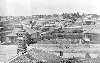
Photograph, Surrey Hills - Looking East from Essex Road, circa 1900, c1900
Date is approximate. Two original post cards of this image - "Surrey Hills - looking East" - were donated by Stephen Wyatt on 10 March 2012. One is blank; the other has been sent to Mrs A Wyatt, C/O Mrs E Young, 'Grand View', Warburton from daughter Nellie from 'The Quantocks', Surrey Hills - postmarked 10 Dec 1906. There is also a reproduction of this image in a framed collage of Surrey Hills photos.This is the earliest known image of the Surrey Gardens. The layout was originally designed by William Guilfoyle, who also designed Melbourne’s Royal Botanic Gardens.Black and white photo taken from an early postcard. Taken from the roof of a house in Essex Road, it shows the development of housing between Essex and Union Roads and includes the section of land fenced off for the Surrey Gardens with paths roughly laid out, one existing tree but no tree planting. The houses depicted are largely Edwardian timber buildings with corrugated rooves. There are still some vacant blocks. Kirkland on Union Road can be seen in the distance, as can some of the shops along Canterbury Road.Lower LHS within original image: " Surrey Hills - Looking East"; on the rear "No 17" in black pen in top LH corner.edwardian style, residential development, kirkland, essex road, suffolk road, norfolk road, surrey gardens, post card -
 Surrey Hills Historical Society Collection
Photograph, Nethercourt Private Hospital in Union Road Surrey Hills, 1976
The 3 front blocks facing Union Road were subdivided off in circa 1967, so this building now faces Barton Street. Since 1984 it has been a private residence. It was originally built in c1890 and from 1896 it was used as facilities for Surrey College, a private boys' boarding school. Dr F Darling was Principal. From 1935-1960s it became Nethercourt Private Hospital. This had previously operated from 1921 in Wilson Street. Later it was known as St Jude's Hospital; this closed in 1983.Black and white photo of Nethercourt Private Hospital taken from Union Road. It shows a 3 storey brick rendered building painted in a light colour. It is fronted by a paling fence and with a vacant area in the foreground, on which there is a bare-leafed mature tree to the right and an evergreen tree to the left. The fence appears to be new suggesting that the photo was taken at the time of subdivision of the land.The original has the following inscriptions: Top: In black biro "D Hall our collection / hall / family" in Jocelyn Hall's writing. Below in lead pencil "Old entrance of / St Judes" - unknown hand; presumed to be Duncan Hall's. In black biro in Jocelyn Hall's hand: "Taken c. 1976." nethercourt private hospital, the surrey college, norwich hall, st judes hospital, barton street, medical services, education, dr f darling -
 Surrey Hills Historical Society Collection
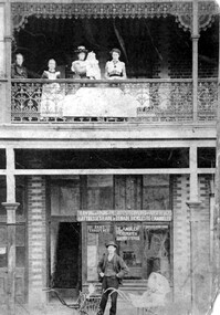
Photograph, Fred Ambler and Family
... building on the corner of Union and Sunbury Roads, c.1910. Fred... in 1888 reported: "Splendid block of brick buildings reaching ...Fred Ambler and family at Albert Mills Premier Land Agency building on the corner of Union and Sunbury Roads, c.1910. Fred had his carpenter and upholstery business on the ground level and his home above. (No.1) Premier Land Agency Building, was built in 1886-7 by Albert Mills, builder, at 122 Union Road, on the corner of Sunbury Crescent, opposite the Railway Station. Photo shows his wife and family. Alfred died in 1890 and the family moved. The Boroondara Standard in 1888 reported: "Splendid block of brick buildings reaching completion in Union Road adjacent to railway line – 2 storey. Frontage 120 feet for Premier Land Agency. Shops at Ground Level." A sepia coloured photograph of a two storey terrace building with 3 ladies and 2 children standing on the balcony. Downstairs, a gentleman stands outside the shopfront beside two prams. There is a child in one pram.albert mills premier land agency building, (mr) fred ambler, union road, carpenter, upholsterer, sunbury crescent -
 Surrey Hills Historical Society Collection
Work on paper - Photograph, Nethercourt Private Hospital, Surrey Hills, c 1924, 1924
Notes from a previous collection coordinator indicate that Miss Lucy Musselwhite (Lillywhite) opened the hospital in 1914 and Matron Eliza Tank took it over in 1921 and named it Nethercourt Private Hospital. However recent research suggests that Miss Musselwhite (name confirmed) moved from Tooronga to Wilson Street some time between 1903 and 1909. She and her mother Elizabeth are listed in the 1909 electoral rolls in Wilson Street and Lucy's occupation is given as nurse. (It is of course possible that the property was a residence only at this time and later opened as a private hospital.) The name Nethercourt was used prior to Matron Eliza Tank taking over. Her daughter Irene was also a nurse at Nethercourt. Lucy Musselwhite was born in 1873 in Hampshire. She married Henry James Dore in later life and lived in Brenbeal Street, Balwyn. She died in 1955. In 1930 / 1935 Matron Tank transferred the hospital to 219-223 Union Road. Later it was known as Norwich Hall / St Jude's. Mosgiel Hospital in Mont Albert Road also opened in 1924. After this time home births became less common. Nethercourt Hospital closed in the 1960s.Small hospitals such as this one were primarily used for midwifery, preceding the development of larger centralised general hospitals. Black and white photo of Nethercourt Private Hospital at 11 Wilson Street in c 1924 taken from the street in winter. The building is Victorian in style; block-fronted with lacework detail to the verandah and has 2 chimneys. It is set behind a wooden picket fence behind which is a well-manicured hedge which appears to have been grown across the front entrance gate.nethercourt private hospital, midwifery, hospitals, matron eliza tank, miss lucy musselwhite, miss irene tank, mrs irene anderson -
 Surrey Hills Historical Society Collection
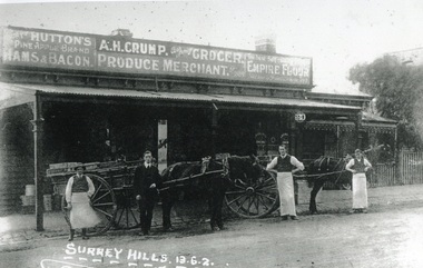
Photograph, Alfred Henry Crump's grocery and produce store in Canterbury Road, Surrey Hills, 1913, 1913
This building was adjacent to Surrey Lodge, on the corner of Canterbury and Union Roads. The store was established by George Sim in 1885 and in 1889 he set up the 1st Surrey Hills Post Office here. The business was bought by Alfred Claude Geer in 1909; the Camberwell Rate books show that from 1913 Geer remained owner but the business was occupied by Alfred Henry Crump; confirmed by electoral rolls for 1913-1918. Prior to moving to Surrey Hills, Alfred was a grocer in Dandenong. Otto Kuhn was Alfred Crump's store manager and may have taken this photo. Alfred married Hazel May Ordish in 1913 in Dandenong. The marriage notice in the Argus on 5 July indicates that the couple resided at 'Hazeldene' in Leopold Crescent. Moran and Cato had already established a business across Union Road from McNeill's Hotel and in time this business and one other grocery store opposite closed as a result.Black and white photo of A H Crump's grocery and produce store in Canterbury Road, Surrey Hills in 1913. There are 4 men and 2 horse-drawn carts in front of a timber single-storey building with a verandah with a corrugated-iron roof. At least one of the carts has "A H CRUMP" painted on the side. Three of the men are wearing long white aprons; the other, AH Crump, is in a suit. Advertising signs on the hoardings are for Huttons hams and bacon and Empire flour. Cadbury's cocoa is advertised on the shop window. The hoarding above the verandah also indicates that the business was established in 1884. There is a block-fronted single storey house with a picket fence adjacent to the shop, to the east along Canterbury Road."SURREY HILLS.13.6.2" diagonally across the bottom LH side of the photo.post offices, grocers, shops, businesses, horse drawn vehicles, alfred henry crump, alfred crump, alfred claude geer, alfred geer, otto kuhn, george sim, hazel may ordish, hazel may crump -
 Surrey Hills Historical Society Collection
Photograph, Grovedale Road Quarry in the 1920s - looking south, c1920
The quarry was part of John Butler Maling's property. He was one of the original settlers of the area and farmed the area between Weybridge Street and Whitehorse Road. Clay was quarried from part of this area and used to make the bricks used in the construction of his home, known as 'Ancyra'. This is still extant at the corner of Weybridge and James Streets. Maling grazed cows and used the quarry as a water source. He was the uncle of John Butler Maling, Mayor of Camberwell. He was married to Kate Conlon in 1882. They had 3 children: Silas Young, Alick and Zillah. Maling was born in c1829 in Shepreth, Cambridgeshire; he died in Surrey Hills on 9 October 1912 and is buried in Box Hill Cemetery - CE-*-0586. Mrs Kate Maling (born c1859 in Co Meath, Ireland) died at the property on 8 March 1921. She is buried in Brighton General Cemetery. Probate was valued at over 10,000 pounds and included other properties in Sandringham, Hawthorn and Macedon. At the time of her death the Surrey Hills property was described as being 23 acres with 2 brick houses, 1 cow, 2 heifers and 40 fowls or chickens. The property was subdivided after her death. The property was subdivided into 110 house blocks in c1923 - see Maling's Estate subdivision flyer on the State Library of Victoria's website. This shows that the Grovedale Park site had been acquired by Camberwell Council by this time. An attached newspaper clipping documents prices realised for a cross-section of blocks. The MMBW map of 1925, also on the SLV website, shows the outline of the clayhole / quarry. The quarry was filled in after several drownings or near drownings and the land is now occupied by a park and playground, known as Grovedale Road Park, maintained by the City of Boroondara. Beckett Park is sited on horizon to the left beyond the trees. This documents the landscape prior to close settlement and is material to early building and farming in the Surrey Hills area.Black and white photo of the quarry between Grovedale Road and James Street taken in the 1920s and looking south. In the foreground is an area of water with reeds in the LH corner. Beyond on the high banks there are single storey houses in the background and (?) some light poles. An object that looks like a tank on posts is in a cutting on the far bank.quarries, grovedale road, james street, clay quarries, farming, kate conlon, kate maling, john butler maling, ancyra