Showing 1416 items matching "bushfires"
-
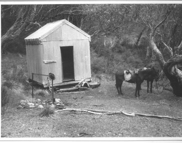
 Parks Victoria - Wilsons Promontory Lightstation
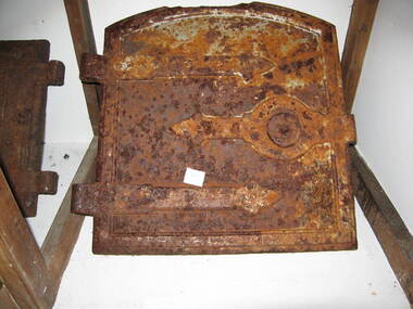
Door, oven
The collection includes a small number of cast iron kitchen range components which appear to originate from more than one fuel-burning cooker. They are possibly relics from the two nineteenth century kitchens destroyed in the 1951 bushfire or bits from abandoned obsolete cookers. There are two oven doors, both with different types of hinges and handles discernible despite their badly corroded condition. One door is rectangular with a raised edging and a handle in the shape of a fist gripping a rod; the other door has a slightly curved top and is also framed and retains its strap hinges and central lock/handle. Door from a fuel burning domestic oven. It has a slightly curved top, is framed and retains its strap hinges and central lock/handle -
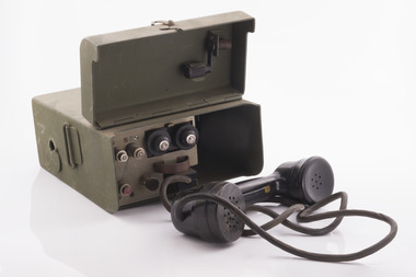
 Forests Commission Retired Personnel Association (FCRPA)
Radio set
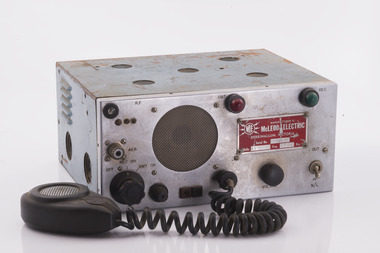
After the 1939 bushfires, the Forests Commission invested heavily in a radically new communications network. After suffering some inevitable delays due to the War, radio VL3AA switched into full operation in October 1945 proudly beaming out 200 watts across the State. The communication systems were regarded at the time to be more technically advanced than the police and the military. These pioneering efforts were directed by Geoff Weste, and later technical experts like Rex Philpot, John Whitehead, Charlie Reisinger and many others who designed, built and repaired most of the radio equipment. There was a dedicated radio laboratory at Surrey Hills in Melbourne.Radio setManufactured by McLeod Electric - Derrinallumradios, forests commission victoria (fcv) -
 Forests Commission Retired Personnel Association (FCRPA)
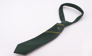
Uniform - Forests Commission Victoria (FCV) tie and epaulets (to be worn on polyester shirt) as dress uniform, pre 1984
Polyester shirts plus a green tie and epaulets were the only form of dress unform issued to FCV staff. In later years a brown tie was available. Blue work overalls and safety boots were issued for bushfire work. These were replaced with the now familiar bright green overalls in about 1984. There were no dress pants, jumpers, jackets or shoes issued. This led to a long running dispute between the staff association and the Commission over departmental uniform policy at the time. David Parnaby was a District Forester and accomplished cartoonist who provided insightful and humorous commentary on uniforms through the Victorian State Forester’s Association Newsletter.Example of early staff uniform.Green polyester tie with yellow stripe and round FCV logo. Green FCV epaulet to be worn on polyester shirt as dress uniform. uniforms, forests commission victoria (fcv) -
 Forests Commission Retired Personnel Association (FCRPA)
Radio set, STC Star Radio Telephone
After the 1939 bushfires, the Forests Commission invested heavily in a radically new communications network. After suffering some inevitable delays due to the War, radio VL3AA switched into full operation in October 1945 proudly beaming out 200 watts across the State. The communication systems were regarded at the time to be more technically advanced than the police and the military. These pioneering efforts were directed by Geoff Weste, and later technical experts like Rex Philpot, John Whitehead, Charlie Reisinger and many others who designed, built and repaired most of the radio equipment. There was a dedicated radio laboratory at Surrey Hills in Melbourne.Radio setSTC Star Radio Telephone Type FR5.1.25-STradios, forests commission victoria (fcv) -
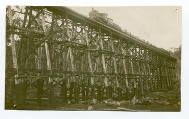
 Orbost & District Historical Society
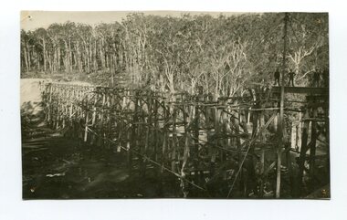
Photograph - Photograph. black + white
The Stony Creek Trestle Bridge was built in 1916 when the existing rail line from Melbourne to Bairnsdale was extended to Orbost. This 97km Bairnsdale to Orbost extension through rugged terrain was reputed to have been the most difficult rail project undertaken in Victoria. In service for over 60 years the bridge was damaged by bushfire in 1980, with the last train crossing in 1987. At 247m long and 20m high, it is the largest standing bridge of its kind in the State, and is listed on the Register of Historic Sites. Built of red ironbark and grey box timber, it is a fine example of the early engineering skills that utilised the resources and materials found on site. (More information Newsletter July 2013)Built during the period 1914-16, of Gippsland Grey Box and Red Ironbark, the Stoney Creek bridge on the East Gippsland Railway is a fine example of early engineering skilll , being constructed without the aid of any of the modern machinery available today. This is a rare photograph and of high significance in showing the bridge under construction.Landscape format black + white photograph (unframed). Four pin holes in each corner, tear to top left quadrant and fold / crease top to bottom in centre of image.construction, 1916, railway bridge, timber industry, trestle construction, stony creek bridge, east gippsland, bairnsdale to orbost line -
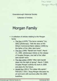 Greensborough Historical Society
Newspaper clippings, Articles on the Morgan family, 1949o
The Sun (c1979) 'The terror remains' [no date] (photocopy). Tells the story of the Eltham Commercial Bank robbery (1949) by the father of the ‘after dark twins’. The Sun (1990) 'Bandit twin freed', March 14, 1990. (photocopy) Article on the release of Douglas Morgan, one half of the ‘after dark bandit’ twins. The Age online (2009) 'After dark bandit steps into the light of giving'. March 7 2009. Douglas Morgan outlines his work in 2009 and plans for the future. Herald Sun (2011) 'Ex-robber lifts spirits'. February 2 2011. Doug Morgan discusses his art and work with survivors after the 2009 bushfires. 4 newspaper clippings (some photocopies).douglas morgan, peter morgan, after dark bandits, robberies, artists -
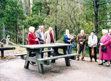 Eltham District Historical Society Inc
Photograph, Dedication of picnic table at Wilks Creek Bridge, Marysville by Marysville Historical Society, 13 October 1993, 13/10/1993
Wilks Creek Bridge was built in 1870. It was last used for heavy vehicle traffic in 1980 and left to decay until it was demolished in 2008. The last remnants of the timber structure were destroyed in the Black Saturday bushfire of 7 February 2009. [from EDHS Newsletter No. 93, November 1993:] OTHER NEWS A small group of members represented the Society at the opening of the picnic ground at the historic Wilks Creek Bridge at Marysville. The event included the launching of a booklet by our friend Ann Thomas on the history of the bridge which was located on the old Yarra Track coaching route between Eltham and Woods Point. Ann has donated a copy of the booklet to our Society.Two colour photographsactivities, marysville, wilks creek bridge -
 City of Moorabbin Historical Society (Operating the Box Cottage Museum)
Newsletter, City of Moorabbin Historical Society No. 10 Vol. 4 October 1964, City of Moorabbin Historical Society Newsletter No. 10 Vol. 4 October 1964, 1964
Topics; Bushfire 1907; Library; Historian Report The Aims of the CMHS are ‘to record the history of the City, and register something of the Australian Atmosphere, which the necessary speed-up in post-world-war two (WW11) immigration has caused to be lost; to produce a magazine at regular intervals, featuring the work of pioneers and the changing Australian scene; to work constantly with a long range view towards building a hall where records and exhibits can be housed’ (1961) The Original Newsletters reflect the history and heritage of the former City of Moorabbin — derived from Mooroobin, ‘a resting place’ in the Bunurrung spoken language. In 1994, the City of Moorabbin was integrated into the Cities of Bayside, Glen Eira, Kingston and Monash. This is Newsletter No. 10 Vol. 4 of the CMHS October 1964 CMHS obtained a Kingston City Council Community Grant 2016 for the digitization and preservation of these Original CMHS Newsletters commenced in 1961 Foolscap L34cm x W 21cm paper printed on both sides folded for 4 pages CITY OF MOORABBIN HISTORICAL SOCIETY NEWSLETTER / Vol. 4 No. 10 October 1964 / / (Affiliated with the Royal Historical Society of Victoria )./ PRESIDENT R.Ashley SECRETARY Mrs L Harvey HISTORIAN T.A.Sheehy city of moorabbin historical society 1961, sheehy t.a., newsletters, library, beaumaris bushfire 1907; -
 Forests Commission Retired Personnel Association (FCRPA)
FCV testing meter
After the 1939 bushfires, the Forests Commission invested heavily in a radically new communications network. After suffering some inevitable delays due to the War, radio VL3AA switched into full operation in October 1945 proudly beaming out 200 watts across the State. The communication systems were regarded at the time to be more technically advanced than the police and the military. These pioneering efforts were directed by Geoff Weste, and later technical experts like Rex Philpot, John Whitehead, Charlie Reisinger and many others who designed, built and repaired most of the radio equipment. There was a dedicated radio laboratory at Surrey Hills in Melbourne. The purpose and operation of this particular instrument is unknown.FCV testing meterMade in the radio laboratory of the Forests Commission Victoriaradio, forests commission victoria (fcv) -
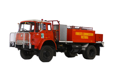 Department of Energy, Environment and Climate Action
Bedford M Series fire tanker
Ash Wednesday Veteran This Bedford M Series tanker spent its working days at the Forests Commission depot at Gembrook, and among its many forays, fought the deadly Ash Wednesday bushfires at nearby Upper Beaconsfield and Cockatoo on 16 February 1983. Earlier in 1975, the M Series tankers underwent a design change at the Altona North workshops, replacing the cylindrical water tank with a “V” bottom 4090 litre water tank that sat low between the chassis rails to reduce its centre of gravity. Aluminium heat shields were also added to protect the pump operators on the back. While generally considered "bulletproof" the petrol fuel lines on this particular model were very prone to vaporise in the heat causing the motor to stall, often at the most dangerous moment.... in this case frightening the hell out of its driver, affable knockabout bloke, and firefighting legend Lex Wade. Some jokingly said this design quirk was an inbuilt safety feature to stop crews getting too close to the fire in the first place. The Gembrook tanker was later sent into the workshop and all its brake and fuel lines fitted with heat resistant lagging. Fortunately, this remarkable bushfire survivor was rescued from the scrap heap by Lex and fire equipment wizard Barry Marsden upon its retirement from a loyal and lengthy service. After a lick of fresh paint and most of its battle scars "buffed out", this time-honoured veteran now takes pride of place at the Altona North workshop.Bedford M series fire tankerMZF 347fire pump, fire tanker, forests commission victoria (fcv) -
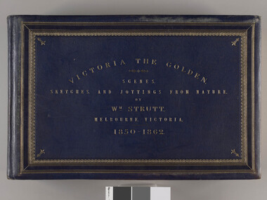 Parliament of Victoria
Victoria the Golden, Strutt, William 1825-1915, Victoria the golden : scenes, sketches, and jottings from nature, 1850-1862, 1850-1862, c.1895
"Victoria the Golden" documents life in Victoria between 1850 and 1862 as viewed by artist William Strutt. Momentous events in the Colony’s history such as Separation Day (1 July 1851), the sitting of the first Legislative Council (13 November 1851), the death of Burke (June 1861) and the Black Thursday bushfires (6 February 1851) are depicted. In 1907 the Premier of Victoria Thomas Bent purchased "Victoria the Golden" from Strutt for £120 and presented it to the Library. The album depicts events in chronological order with what Strutt considered “fidelity to nature and accuracy”, so that present day Victorians may view the sketches “as records of what we may now look upon as the dim past in the rapidly progressive history of Victoria”. Victoria the Golden is celebrated as one of the Parliament’s great treasures. It is a testament to William Strutt’s skill as a draughtsman and contains over 100 assorted images which were executed between the years of 1850-1862. Strutt’s particular talent was to be able to step back and record each event with particular care to detail. Many of the pieces contained within this album are littered with notes, such as the correct resting position of a corporal’s sword or details about the cloth and cut of a subject’s jacket. Strutt also notes in one of his many sketches of the new Legislative Council chamber at Spring Street that the President, Sir James Palmer, is seated ‘a little too high’ (page 30). Throughout the album, Strutt’s illustrations bring to life the diverse nature and peoples of the new colony. His range of subjects is comprehensive and includes parliamentarians, lawyers, wives and daughters, merchants, labourers, police and military officers, indigenous communities, farmers, miners, prisoners and explorers. The everyday and the extraordinary are depicted with each turn of the page. 44 leaves heavy card, approximately 1mm thick. Sketches, watercolours and prints of varying sizes and papers are glued onto the pages. Full leather binding in blue leather with title and decorative border in gold. There are four raised bands on the spine, with gold decoration on the bands and at the head and tail of the spine. Marbled end papers and flyleaves. Gold on the edges of the book block. Card pages have a sheet of mottled blue paper on recto. Album leaf connection is a guarded system with stiff stubs and cloth hinges. Each page has a sheet of glassine paper attached at the binding edge to protect the images. Many pages stamped with "Parliament of Victoria" verso. Printed in gold, recto: "VICTORIA THE GOLDEN/ SCENES,/ SKETCHES,/ AND JOTTINGS FROM NATURE./ BY/ Wm. STRUTT/ MELBOURNE, VICTORIA./ 1850-1862" First pages include handwritten 'introductory remarks' and index of plates.parliament of victoria, colony of victoria, separation day, victorian legislative council, burke and wills expedition, wills, william john, 1834-1861, burke, robert o'hara, 1821-1861, strutt, william, 1825-1915, bent, thomas sir, 1838-1909, native police corps, fawkner, john pascoe, 1792-1869, black thursday bushfires, gold rush, princes bridge, melbourne -
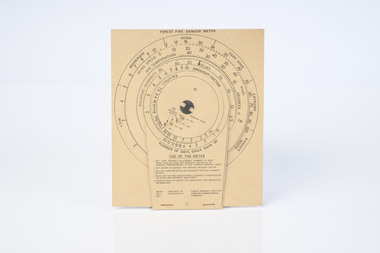 Department of Energy, Environment and Climate Action
McArthur Forest Fire Danger Meter MK5 1973
The Forest Fire Danger Index (FFDI) was originally invented by the grandfather of Australian bushfire science, Alan Grant McArthur, during the 1950s and ‘60s. Alan published his landmark paper, “Controlled burning in eucalypt forests” in 1962. Leaflet No. 80, as it was known, proved a turning point for forest and fire managers across Australia. More importantly, Alan was very practical forester and wanted his work to be useful to people in the field, so after several iterations he came up with the now familiar circular slide rule called the Forest Fire Danger Meter (FFDM). The Mk 4 version first appeared in operational use in 1967. This is the Mark 5 from 1973Alan McAthur's scientific legacy with the FFDI meter is unquestionably huge and has served forest firefighters very well over the decades.Cardboard fire danger meter Series of circular slide rules to calculate Forest Fire Danger Index (FFDI)forests commission victoria (fcv), bushfire -
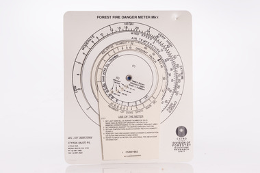 Forests Commission Retired Personnel Association (FCRPA)
McArthur Forest Fire Danger Meter - Mk 5, 1992
The Forest Fire Danger Index (FFDI) was originally invented by the grandfather of Australian bushfire science, Alan Grant McArthur, during the 1950s and ‘60s. Alan published his landmark paper, “Controlled burning in eucalypt forests” in 1962. Leaflet No. 80, as it was known, proved a turning point for forest and fire managers across Australia. More importantly, Alan was very practical forester and wanted his work to be useful to people in the field, so after several iterations he came up with the now familiar circular slide rule called the Forest Fire Danger Meter (FFDM). The Mk 4 version first appeared in operational use in 1967. This is the Mark 5 from 1992Alan McAthur's scientific legacy with the FFDI meter is unquestionably huge and has served forest firefighters very well over the decades.Control burning meter Series of circular slide rules to calculate Forest Fire Danger Index (FFDI)bushfire, forests commission victoria (fcv) -
 Forests Commission Retired Personnel Association (FCRPA)
Radio Telephone with handset
After the 1939 bushfires, the Forests Commission invested heavily in a radically new communications network. After suffering some inevitable delays due to the War, radio VL3AA switched into full operation in October 1945 proudly beaming out 200 watts across the State. The communication systems were regarded at the time to be more technically advanced than the police and the military. These pioneering efforts were directed by Geoff Weste, and later technical experts like Rex Philpot, John Whitehead, Charlie Reisinger and many others who designed, built and repaired most of the radio equipment. There was a dedicated radio laboratory at Surrey Hills in Melbourne. Little is known about this particular radio handsetField radio telephone with handset.radios, forests commission victoria (fcv) -
 Orbost & District Historical Society
black and white photograph, 1977?
In 1977 great efforts were being made to preserve this bridge, the highest trestle bridge in Victoria at Stoney Creek. The Stony Creek Trestle Bridge was built in 1916 when the existing rail line from Melbourne to Bairnsdale was extended to Orbost. This 97km Bairnsdale to Orbost extension through rugged terrain was reputed to have been the most difficult rail project undertaken in Victoria. In service for over 60 years the bridge was damaged by bushfire in 1980, with the last train crossing in 1987. At 247m long and 20m high, it is the largest standing bridge of its kind in the State, and is listed on the Register of Historic Sites. Built of red ironbark and grey box timber, it is a fine example of the early engineering skills that utilised the resources and materials found on site.The Bairnsdale to Orbost rail line contains the most varied range of timber & timber composite bridges on any Victorian line. The Stoney Creek bridge is listed on the Victorian Heritage Register for its architectural and historical significance.A black / white photograph of a very large trestle bridge. a steam locomotive, with loaded goods trucks, is on the bridge. stoney-creek trestle-bridge railway east-gippsland-railway -
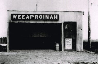 Otway Districts Historical Society
Photograph, R. Preston, Weeaproinah mallee shed, c.1920, c.1920
Originally named 'McInnes' after a local selector, this station opened during construction of the Crowes railway on 1 May 1911. The name was altered to Weeaproinah, the second station of that name, on 9 December 1912, after the parish in which the station was situated. (The original 'Weeaproinah' on the railway became earlier 'Dinmont' in the Olangolah Parish.) The station comprised a passenger shelter and a loop siding with a ramped platform for a sheep and pig race. A departmental residence was built for a track repairer based at the station, but no station or caretaker staff were employed there. The residence was burnt down during the 1919 bushfire but it was replaced and remained in use as a departmental residence until 1930. Weeaproinah became an unattended crossing station in December 1927 under the Train Section Order system.B/W. Weeaproinah mallee shed. In the shed there are five large wall-mounted posters and a cream can. An unlocked door with a "Skins / Hides" poster gives access the inside. A tree trunk stands to the right.weeaproinah; railways; shed; -
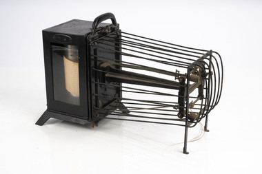 Department of Energy, Environment and Climate Action
Thermo-hygrograph
Bushfire behaviour is influenced by many factors including temperature, relative humidity (RH), forest type, fuel quantity and fuel dryness, topography and even slope. Wind has a dominant effect on the Rate of Spread (ROS), as well as fire size, shape and direction. Temperature and relative humidity have major impacts on fuel dryness and therefore upon the availability of fuel for combustion. A thermo-hygrograph measures and records both temperature and humidity. It produces a continuous record by drawing ink traces on a paper chart held in revolving cylinder. Humidity is measured by shortening or lengthening of specially treated horse hair. Temperature is measured by means of a bi-metallic strip. This particular instrument is a seven day recorder. The instrument is driven by clockwork. Thermo-hygrographNegretti & Zambra -
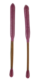
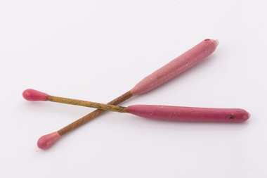 Forests Commission Retired Personnel Association (FCRPA)
Delayed Action Incendiary Device (DAID), Bryant and May - Richmond, Large double ended match
The Forests Commission developed the use of helicopters for aerial ignition from the mid 1960s. Bryant and May at Richmond worked with the Commission to develop a Delayed Action Incendiary Device. DAIDs as the were known, had an overall length of 180 mm, striker end length - 10 mm. Ignition end length - 80 mm, then a layer of high melting point wax (to prevent accidental ignition when rubbing together in transit). Both ends coated with a modified match head compound with safety fuse exposed length between coated match ends. There was a 17-second delay from when the small end was struck to an intense flaming of the large end, which lasted for 40 seconds. DAIDs were dangerous so were stored in a metal box outside the helicopter along with a disposable striker patch attached with a quick release pin to a special half-door. The first test was with a Bell 47G on 4 October 1967 and the first use, anywhere in the world, of DAIDs to backburn a large bushfire was undertaken in north eastern Victoria in February 1968. There was a crash of an FCV helicopter conducting aerial ignition near Wandiligong on 19 April 1978 with the tragic death of two forest officers and their pilot. The crash led to the immediate end of the use of DAIDs and the adoption of the safer Premo ping-pong ball incendiary machine which originally came from Canada but was modified at the Altona workshops. Overall, the development of aerial ignition techniques by the Forests Commission from the mid-1960s resulted in a steady climb in the area burnt each year…. peaking at 477,000 ha in 1980-81 and with an impressive 10-year rolling average of 220,000 ha around the time of 1983 Ash Wednesday Bushfires.Developed in Victoria for aerial ignitionLarge double ended match used for aerial ignition and back burning by dropping from a helicopterbushfire, forests commission victoria (fcv) -
 Department of Energy, Environment and Climate Action
Delayed Action Incendiary Device (DAID)
The Forests Commission developed the use of helicopters for aerial ignition from the mid 1960s. Bryant and May at Richmond worked with the Commission to develop a Delayed Action Incendiary Device. DAIDs as the were known, had an overall length of 180 mm, striker end length - 10 mm. Ignition end length - 80 mm, then a layer of high melting point wax (to prevent accidental ignition when rubbing together in transit). Both ends coated with a modified match head compound with safety fuse exposed length between coated match ends. There was a 17-second delay from when the small end was struck to an intense flaming of the large end, which lasted for 40 seconds. DAIDs were dangerous so were stored in a metal box outside the helicopter along with a disposable striker patch attached with a quick release pin to a special half-door. The first test was with a Bell 47G on 4 October 1967 and the first use, anywhere in the world, of DAIDs to backburn a large bushfire was undertaken in north eastern Victoria in February 1968. There was a crash of an FCV helicopter conducting aerial ignition near Wandiligong on 19 April 1978 with the tragic death of two forest officers and their pilot. The crash led to the immediate end of the use of DAIDs and the adoption of the safer Premo ping-pong ball incendiary machine which originally came from Canada but was modified at the Altona workshops. Overall, the development of aerial ignition techniques by the Forests Commission from the mid-1960s resulted in a steady climb in the area burnt each year…. peaking at 477,000 ha in 1980-81 and with an impressive 10-year rolling average of 220,000 ha around the time of 1983 Ash Wednesday Bushfires.Developed in Victoria for aerial ignition by the FCV and Byant & MayLarge double ended match used for aerial ignition and back burning by dropping from a helicopterforests commission victoria (fcv), bushfire, planned burning -
 Kiewa Valley Historical Society
Photo - Bogong Township, March 1944
In 1940 Field Headquarters for the Kiewa Scheme were established at Bogong with office, workshop facilities and accommodation for workmen, staff and some families constructed. (There had been a 'tent camp' on this site in 1939 but was destroyed by bushfires) Construction of accommodation continued until 1947. A total of 40 houses plus a hostel for single staff, post office, police station, medical centre and primary school all with water and sewerage and electricity supply. The staff hostel was known as Kiewa House and is now occupied by the Education Department. Lake Guy was named after Mr. L.T. Guy who was the Resident Engineer in charge of construction work and associated activities on the Kiewa area. He held this position from 1939 to November 1946 when he was transferred to Head Office. The Bogong Township was developed firstly as an accommodation centre (base camp) for construction workers employed under the Kiewa Hydroelectric Scheme. Due to the influx of European workers into the Township the beautification of the immediate surrounds (gardens etc.) had a distinct European flavour. This environment has been very beneficial for tourism in later years. At the completion of the scheme, in the 1960's, the village was opened to public/tourism use. Strict environmental control has not allowed for any extensive redevelopment in tourist accommodation and basically restricted it to the accommodation initially built for the construction workers. Activities such a bike riding, snow skiing, restricted horse riding and bush walking on the Alpine plains and mountains are now a viable part of the Kiewa Valley Tourist Industry. The lake is one of the many water storage reservoirs used to supply the power stations their main power to run the huge turbines generating the final product, electricityBlack and white photograph of Bogong Township taken March 1944Handwritten on the back of photo - Township March '44bogong village, secv -
 Kiewa Valley Historical Society
Photograph - Bogong Village (7 copies), Approx 1940
In 1940 Field Headquarters for the Kiewa Scheme were established at Bogong with office, workshop facilities and accommodation for workmen, staff and some families constructed. (There had been a 'tent camp' on this site in 1939 but was destroyed by bushfires) Construction of accommodation continued until 1947. A total of 40 houses plus a hostel for single staff, post office, police station, medical centre and primary school all with water and sewerage and electricity supply. The staff hostel was known as Kiewa House and is now occupied by the Education Department. Lake Guy was named after Mr. L.T. Guy who was the Resident Engineer in charge of construction work and associated activities on the Kiewa area. He held this position from 1939 to November 1946 when he was transferred to Head Office. The Bogong Township was developed firstly as an accommodation centre (base camp) for construction workers employed under the Kiewa Hydroelectric Scheme. Due to the influx of European workers into the Township the beautification of the immediate surrounds (gardens etc.) had a distinct European flavour. This environment has been very beneficial for tourism in later years. At the completion of the scheme, in the 1960's, the village was opened to public/tourism use. Strict environmental control has not allowed for any extensive redevelopment in tourist accommodation and basically restricted it to the accommodation initially built for the construction workers. Activities such a bike riding, snow skiing, restricted horse riding and bush walking on the Alpine plains and mountains are now a viable part of the Kiewa Valley Tourist Industry. The lake is one of the many water storage reservoirs used to supply the power stations their main power to run the huge turbines generating the final product, electricity. Evidence can be seen of the 1939 bushfires.Set of 7 identical black and white photographs of Bogong Village after 1939 bush firesHandwritten on the back of one photo - Bogong Village approx. 1940, after 1939 bush fires. Staff residences to left. Kiewa House, General offices and test lab to the right. Hand drawn map on the back of one photo.bogong village, secv -
 Kiewa Valley Historical Society
Photo - Bogong Village Township, October 8, 1946
In 1940 Field Headquarters for the Kiewa Scheme were established at Bogong with office, workshop facilities and accommodation for workmen, staff and some families constructed. (There had been a 'tent camp' on this site in 1939 but was destroyed by bushfires) Construction of accommodation continued until 1947. A total of 40 houses plus a hostel for single staff, post office, police station, medical centre and primary school all with water and sewerage and electricity supply. The staff hostel was known as Kiewa House and is now occupied by the Education Department. Lake Guy was named after Mr. L.T. Guy who was the Resident Engineer in charge of construction work and associated activities on the Kiewa area. He held this position from 1939 to November 1946 when he was transferred to Head Office. The Bogong Township was developed firstly as an accommodation centre (base camp) for construction workers employed under the Kiewa Hydroelectric Scheme. Due to the influx of European workers into the Township the beautification of the immediate surrounds (gardens etc.) had a distinct European flavour. This environment has been very beneficial for tourism in later years. At the completion of the scheme, in the 1960's, the village was opened to public/tourism use. Strict environmental control has not allowed for any extensive redevelopment in tourist accommodation and basically restricted it to the accommodation initially built for the construction workers. Activities such a bike riding, snow skiing, restricted horse riding and bush walking on the Alpine plains and mountains are now a viable part of the Kiewa Valley Tourist Industry. The lake is one of the many water storage reservoirs used to supply the power stations their main power to run the huge turbines generating the final product, electricityBlack and white photograph of Bogong Village which appeared in the Herald Sun newspaper on October 8, 1946. Page 13Handwritten on the back - Town of Bogong on a rugged mountain slope above Lake Guy. State Electricity Committee workers on the Kiewa Hydro Electric scheme live here in all electric homes. Stamped on the back - Copyright Not for reproduction Herald Sun Feature Service Melbourne Australiabogong village; lake guy; kiewa hydro electric scheme -
 Kiewa Valley Historical Society
Postcard - Lake Guy and Bogong Village
In 1940 Field Headquarters for the Kiewa Scheme were established at Bogong with office, workshop facilities and accommodation for workmen, staff and some families constructed. (There had been a 'tent camp' on this site in 1939 but was destroyed by bushfires) Construction of accommodation continued until 1947. A total of 40 houses plus a hostel for single staff, post office, police station, medical centre and primary school all with water and sewerage and electricity supply. The staff hostel was known as Kiewa House and is now occupied by the Education Department. Lake Guy was named after Mr. L.T. Guy who was the Resident Engineer in charge of construction work and associated activities on the Kiewa area. He held this position from 1939 to November 1946 when he was transferred to Head Office. The Bogong Township was developed firstly as an accommodation centre (base camp) for construction workers employed under the Kiewa Hydroelectric Scheme. Due to the influx of European workers into the Township the beautification of the immediate surrounds (gardens etc.) had a distinct European flavour. This environment has been very beneficial for tourism in later years. At the completion of the scheme, in the 1960's, the village was opened to public/tourism use. Strict environmental control has not allowed for any extensive redevelopment in tourist accommodation and basically restricted it to the accommodation initially built for the construction workers. Activities such a bike riding, snow skiing, restricted horse riding and bush walking on the Alpine plains and mountains are now a viable part of the Kiewa Valley Tourist Industry. The lake is one of the many water storage reservoirs used to supply the power stations their main power to run the huge turbines generating the final product, electricityBlack and white photographic postcard of Lake Guy and Bogong Village. Kiewa Hydro electric Project (showing Junction Dam in front)Handwritten on the back of postcard ' Like most of our camps, this looks like something from the Canadian Rockies' Stamped on the back - Valentine's Post Card A genuine photographlake guy, bogong village, secv -
 Kiewa Valley Historical Society
Photo - Bogong Township, September 1953
In 1940 Field Headquarters for the Kiewa Scheme were established at Bogong with office, workshop facilities and accommodation for workmen, staff and some families constructed. (There had been a 'tent camp' on this site in 1939 but was destroyed by bushfires) Construction of accommodation continued until 1947. A total of 40 houses plus a hostel for single staff, post office, police station, medical centre and primary school all with water and sewerage and electricity supply. The staff hostel was known as Kiewa House and is now occupied by the Education Department. Lake Guy was named after Mr. L.T. Guy who was the Resident Engineer in charge of construction work and associated activities on the Kiewa area. He held this position from 1939 to November 1946 when he was transferred to Head Office. The Bogong Township was developed firstly as an accommodation centre (base camp) for construction workers employed under the Kiewa Hydroelectric Scheme. Due to the influx of European workers into the Township the beautification of the immediate surrounds (gardens etc.) had a distinct European flavour. This environment has been very beneficial for tourism in later years. At the completion of the scheme, in the 1960's, the village was opened to public/tourism use. Strict environmental control has not allowed for any extensive redevelopment in tourist accommodation and basically restricted it to the accommodation initially built for the construction workers. Activities such a bike riding, snow skiing, restricted horse riding and bush walking on the Alpine plains and mountains are now a viable part of the Kiewa Valley Tourist Industry. The lake is one of the many water storage reservoirs used to supply the power stations their main power to run the huge turbines generating the final product, electricityBlack and white photograph of Bogong Township taken from Little Arthur fire track. September 1953Faded handwritten inscription on back - Bogong Township taken from Little Arthur fire track. Sept 1953bogong village, secv -
 Kiewa Valley Historical Society
Photo - First Bogong Camp, September 1950
In 1940 Field Headquarters for the Kiewa Scheme were established at Bogong with office, workshop facilities and accommodation for workmen, staff and some families constructed. (There had been a 'tent camp' on this site in 1939 but was destroyed by bushfires) Construction of accommodation continued until 1947. A total of 40 houses plus a hostel for single staff, post office, police station, medical centre and primary school all with water and sewerage and electricity supply. The staff hostel was known as Kiewa House and is now occupied by the Education Department. Lake Guy was named after Mr. L.T. Guy who was the Resident Engineer in charge of construction work and associated activities on the Kiewa area. He held this position from 1939 to November 1946 when he was transferred to Head Office. The Bogong Township was developed firstly as an accommodation centre (base camp) for construction workers employed under the Kiewa Hydroelectric Scheme. Due to the influx of European workers into the Township the beautification of the immediate surrounds (gardens etc.) had a distinct European flavour. This environment has been very beneficial for tourism in later years. At the completion of the scheme, in the 1960's, the village was opened to public/tourism use. Strict environmental control has not allowed for any extensive redevelopment in tourist accommodation and basically restricted it to the accommodation initially built for the construction workers. Activities such a bike riding, snow skiing, restricted horse riding and bush walking on the Alpine plains and mountains are now a viable part of the Kiewa Valley Tourist Industry. The lake is one of the many water storage reservoirs used to supply the power stations their main power to run the huge turbines generating the final product, electricityBlack and white photo of Bogong Village. September 1950Handwritten on the back - 1st Bogong Camp. SEC Kiewa Scheme Sept 1950bogong camp, bogong village, secv -
 Kiewa Valley Historical Society
Photo - Bogong Village Township
In 1940 Field Headquarters for the Kiewa Scheme were established at Bogong with office, workshop facilities and accommodation for workmen, staff and some families constructed. (There had been a 'tent camp' on this site in 1939 but was destroyed by bushfires) Construction of accommodation continued until 1947. A total of 40 houses plus a hostel for single staff, post office, police station, medical centre and primary school all with water and sewerage and electricity supply. The staff hostel was known as Kiewa House and is now occupied by the Education Department. Lake Guy was named after Mr. L.T. Guy who was the Resident Engineer in charge of construction work and associated activities on the Kiewa area. He held this position from 1939 to November 1946 when he was transferred to Head Office. The Bogong Township was developed firstly as an accommodation centre (base camp) for construction workers employed under the Kiewa Hydroelectric Scheme. Due to the influx of European workers into the Township the beautification of the immediate surrounds (gardens etc.) had a distinct European flavour. This environment has been very beneficial for tourism in later years. At the completion of the scheme, in the 1960's, the village was opened to public/tourism use. Strict environmental control has not allowed for any extensive redevelopment in tourist accommodation and basically restricted it to the accommodation initially built for the construction workers. Activities such a bike riding, snow skiing, restricted horse riding and bush walking on the Alpine plains and mountains are now a viable part of the Kiewa Valley Tourist Industry. The lake is one of the many water storage reservoirs used to supply the power stations their main power to run the huge turbines generating the final product, electricityBlack and white photograph of Bogong Village from across Lake Guy. Photo mounted on buff cardbogong village, secv -
 Kiewa Valley Historical Society
Photograph - Photographs x 13 - Cattlemen
11 of the 13 photos were taken by Tor Holth and used in his book "Cattlemen of the High Country" first published in 1980. Co writer was Jane Holth (Barnaby). Of the other two photos, one was taken by C. Roper (2 old gentlemen of the High Plains) and the other (Fred Roper, Tom Hollonds, Kyran Marum - early cattlemen) unknown photographer. The book tells the story of the lives of the mountain cattlemen of Victoria's high country, the harsh conditions and challenges they faced when they mustered their cattle before winter to bring them down to lower pastures. Huts were built of any materials available and were scattered about the high plains to provide shelter from the elements. Some are still standing despite the many bushfires that have ravaged the area.The photographs are of historic significance as they are of early pioneers in the cattle industry in the Kiewa Valley. The huts are of significant interest as they show different types of construction and materials as does the cattle yard at Bogong Jack's. All 13 photos are black and white and printed on photographic paper and are of varying size. 1.On the back, hand written in pencil - "Bogong Jacks hut on Fainter Spur". 2.15 in top right hand corner and 120% centre of photo and circled. 2.On the back a typewritten label cut out and fixed with sticky tape "45 b.&w. Cope Hut, known also as the Menzies of the high plains." Lower left corner is a handwritten label, written in red biro, COPE HUT (underlined) V circled and Journeys into History. 3. Top right hand corner '2.32(a) and across the back, written in pencil, 'Wallace's Hut 1976' and 'TOR HOLTH' in red biro on small sticker lower R corner. 4.2.32(c) in pencil top R corner. 'Wallaces Hut 1976' in pencil across back of photo. 5. '42.7a' in pencil top R corner. Written in pencil across back of photo 'Remains of the second Tawanga Hut.' 6. 'Jim Edmundson Mt. Beauty' handwritten in blue biro across back of photo. 7. '2.26' in pencil top R corner. 'Cattle yard at Bogong Jack's' handwritten in blue biro across back of photo. 8. 'Jim Edmondson of Edmondsons hut' written in pencil on back of photo. 9. 'Geoff Wallace Kergunyah' written in pencil on back of photo. 10.' Geoff Wallace Kergunyah' handwritten in pencil on back of photo. 11. 2.11 in pencil top R corner. 'Fred Roper & Jack Platt. Ph. C.Roper' handwritten in orange pen and under, in pencil, '2 old gentlemen of the High Plains.' 12. Written in black pen across back of photo 'Left to right Fred Roper, Tom Hollonds, Kyran Marum - early cattlemen' 13. Hand written on back of photo 'Sid Ryder' photos, cattlemen, high plains, huts -
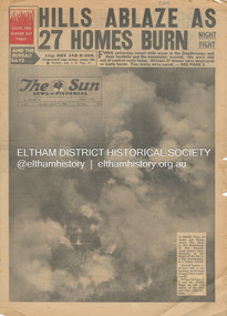 Eltham District Historical Society Inc
Newspaper - Newspaper articles, Sun News-Pictorial, Hills Ablaze As 27 Homes Burn, The Sun News-Pictorial, Monday, January 15, p1, 1962
Various news articles pertaining to the January 1962 Victorian bushfires in the Dandenong and Healesville districts. • Hills Ablaze As 27 Homes Burn; Night Fight, p1 (Illust.) • Yarra Glen, Healesville Saved; Fire into main street, p2 (Illust.) • Flare-up at Montrose, p2 • 20 scouts flee as fire sweeps camp, p2 • Gaol for fires today …, p2 • Timber lost, p2 • Heathmont home lost, but others saved, p2 • The desperate fight, p3 (Illust.) • Rubbish fire got away; Basin blaze, p3 • Panorama of destruction, p3 • Fire Captain Killed; 7 road deaths at week-end, p5 (Illust.) • Heartbreak, ruin as … Fire Sweeps the Hills, pp18-19 .(Illust.) • Tea; they made it for the fire fighters, pp18-19 (Illust.) tom fielding collection, victorian bushfires - 1962, victorian bushfires – 1962, dandenongs, the basin, yarra glen, healesville, montrose, chum creek, scouts, australian logging co., a.w. larkins, heathmont, vermont, r. pearson, mike ryan, vic parker, c.g. wilson, hillside farm, clive brewer, ron anderson, mrs anderson, mt dandenong, healesville rural fire brigade, malcolm barber, yarra flats, r. bicknell, ferny creek, blue hills gues house, heatherset road, sassafras, olinda, presbyterian manse, john gorie, janice gorie, lynette gorie, jacky wilson, patricia cortie -
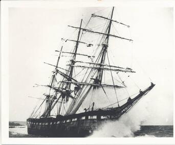 Phillip Island and District Historical Society Inc.
Photograph, The Speke, 22/02/1906
The Speke was an all steel ship of 310 feet, beam of 35 feet and weight of 2,712 tons and triple masted. She was built in 1891 at Carnarvon in Wales for a cost of 22,000 pounds. The wreck of the Speke was purchased for a mere 12 pounds after it went aground in 1906. The Speke had come from Peru to Sydney. She was then on her way to load wheat in Geelong when she ran aground on the 22 February 1906. Captain Tiltson confused a bushfire, near Cowes, for navigation lights. The ship drifted close to shore in Kitty Miller Bay and was eventually holed at 3 pm on the rocks. Life boats were immediately lowered and the ship’s crew all made it to shore except Seaman Frank Henderson, who lost his life.Black & White photograph of The Speke running aground on the south coast of Phillip Island.wreck of the speke, the speke, jack loney -
 Kiewa Valley Historical Society
Photograph from Lake Guy, Bogong Village, Scene from shores of Lake Guy to Mountain range, 1930s to 1950s
In 1940 Field Headquarters for the Kiewa Scheme were established at Bogong with office, workshop facilities and accommodation for workmen, staff and some families constructed. (There had been a 'tent camp' on this site in 1939 but was destroyed by bushfires) Construction of accommodation continued until 1947. A total of 40 houses plus a hostel for single staff, post office, police station, medical centre and primary school all with water and sewerage and electricity supply. The staff hostel was known as Kiewa House and is now occupied by the Education Department. Lake Guy was named after Mr. L.T. Guy who was the Resident Engineer in charge of construction work and associated activities on the Kiewa area. He held this position from 1939 to November 1946 when he was transferred to Head Office.The Bogong Township was developed firstly as an accommodation centre (base camp) for construction workers employed under the Kiewa Hydroelectric Scheme. Due to the influx of European workers into the Township the beautification of the immediate surrounds(gardens etc.) had a distinct European flavour. This environment has been very beneficial for tourism in later years. Strict environmental control has not allowed for any extensive redevelopment in tourist accommodation and basically restricted it to the accommodation initially built for the construction workers. Activities such a bike riding, snow skiing, restricted horse riding and bush walking on the Alpine plains and mountains are now a viable part of the Kiewa Valley Tourist Industry. The lake is one of the many water storage storage reservoirs used to supply the power stations their main power to run the huge turbines generating the final product, electricityThis black and white photograph shot from the shores of Lake Guy toward the mountain range of the Victorian Alps details the early construction of the construction worker's accommodation of the Bogong Village. The paper is of 200gms and is not photographic paper and can be assumed to be a reproduction of an original photobogong village circa 1930 to 1950, kiewa hydro-electricity scheme, victorian alpine region mid 1900s