Showing 19773 items
matching coast
-
 Parks Victoria - Port Campbell Rocket Shed
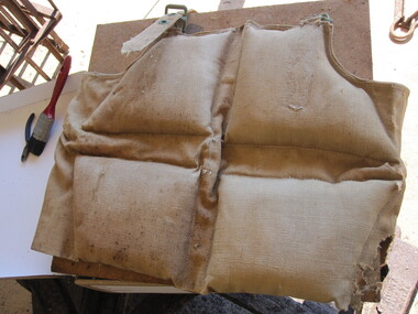
Life jackets
This rocket equipment has been used in various lifeboat and rocket stations on Victorian Coast. It is unclear if this is the original rocket equipment from Port Campbell. This equipment, if not original to the site, has been used in rescue operations and is identical to the equipment that was in use at Port Campbell from C.1890 onwardsTwo canvas lifejackets, one is filled with cotton or silk and the other with cork. The jackets are sewn in sections that hold either the cork or the cotton/silk. One of the lifejackets has a separate strap and brass eyelets and buckles. -
 Parks Victoria - Port Campbell Rocket Shed
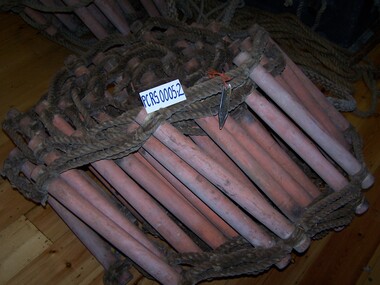
Rope ladders
This rocket equipment has been used in various lifeboat and rocket stations on Victorian Coast. It is unclear if this is the original rocket equipment from Port Campbell. This equipment, if not original to the site, has been used in rescue operations and is identical to the equipment that was in use at Port Campbell from C.1890 onwardsTwo rope ladders, identical in format and length. The rungs are made from another type of material. -
 Parks Victoria - Port Campbell Rocket Shed
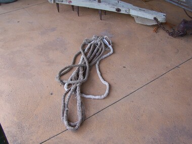
Rope strops
This rocket equipment has been used in various lifeboat and rocket stations on Victorian Coast. It is unclear if this is the original rocket equipment from Port Campbell. This equipment, if not original to the site, has been used in rescue operations and is identical to the equipment that was in use at Port Campbell from C.1890 onwardsFour rope strops, three are of equal length. Lengths of rope spliced or joined to form a circle of approx. 100cm diameter. The long rope is triple laid rope and the three shorter ropes are made of multiple small strings (approx.40) bound together. Use is yet to be determined. -
 Parks Victoria - Port Campbell Rocket Shed
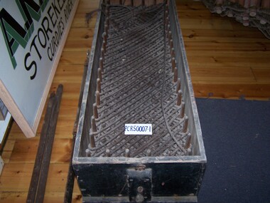
Rocket line
This rocket equipment has been used in various lifeboat and rocket stations on Victorian Coast. It is unclear if this is the original rocket equipment from Port Campbell. This equipment, if not original to the site, has been used in rescue operations and is identical to the equipment that was in use at Port Campbell from C.1890 onwardsRope handled timber box with faking pins. The Rocket Line was attached to the rocket and fired over the ship in distress. The light rocket line, was folded in such a way that it paid out easily as the rocket shot through the air. -
 Parks Victoria - Port Campbell Rocket Shed
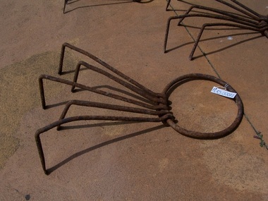
Anchors
This rocket equipment has been used in various lifeboat and rocket stations on Victorian Coast. It is unclear if this is the original rocket equipment from Port Campbell. This equipment, if not original to the site, has been used in rescue operations and is identical to the equipment that was in use at Port Campbell from C.1890 onwardsEach of the five anchors have an iron ring (2 large, 1 medium, 2 small) to which are attached 5 iron hooks. Medium has 4 hooks.Each has an iron ring 2 large, 2 small to which is attached iron hooks. -
 Parks Victoria - Port Campbell Rocket Shed
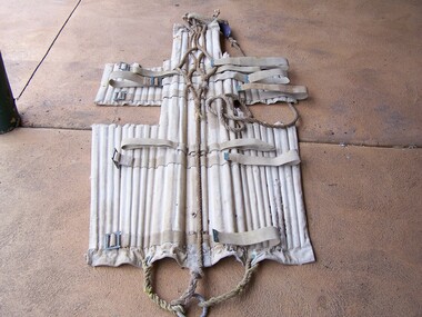
Stretcher
This rocket equipment has been used in various lifeboat and rocket stations on Victorian Coast. It is unclear if this is the original rocket equipment from Port Campbell. This equipment, if not original to the site, has been used in rescue operations and is identical to the equipment that was in use at Port Campbell from C.1890 onwardsBody of rescue stretcher is canvas and timber slats. Straps of canvas webbing attached to sides. Rope loops at either end, rope runs along the length of stretcher. Opens out to secure patient. -
 Parks Victoria - Port Campbell Rocket Shed
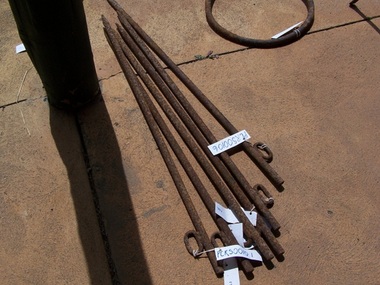
Anchor pegs
This rocket equipment has been used in various lifeboat and rocket stations on Victorian Coast. It is unclear if this is the original rocket equipment from Port Campbell. This equipment, if not original to the site, has been used in rescue operations and is identical to the equipment that was in use at Port Campbell from C.1890 onwardsEach of the six iron pegs has a spike on one end and eyelet on the other. -
 Parks Victoria - Port Campbell Rocket Shed
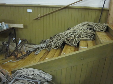
Rope
This rocket equipment has been used in various lifeboat and rocket stations on Victorian Coast. It is unclear if this is the original rocket equipment from Port Campbell. This equipment, if not original to the site, has been used in rescue operations and is identical to the equipment that was in use at Port Campbell from C.1890 onwardsRope, 1cm light line -
 Parks Victoria - Port Campbell Rocket Shed
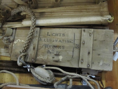
Box
This rocket equipment has been used in various lifeboat and rocket stations on Victorian Coast. It is unclear if this is the original rocket equipment from Port Campbell. This equipment, if not original to the site, has been used in rescue operations and is identical to the equipment that was in use at Port Campbell from C.1890 onwardsRectangular box with fitted lid. All wood. Two rope handles at each end. Inscribed on lid -"Lights Illuminating Wrecks. Mark-IV 3 . 4/7/1910"Inscribed on lid -"Lights Illuminating Wrecks. Mark-IV 3 . 4/7/1910" -
 Flagstaff Hill Maritime Museum and Village
Document - Navigation Chart, Admiralty Office, Lady Bay and Warrnambool Harbour, 1893
This navigation cart of Lady Bay and Warrnambool Harbour was originally surveyed in 1870 but this version includes the update for magnetic variation in 1893. Since the printing of the chart several annotations have been added. These include an additional stamp dated 15-8-1910, a handwritten comment across the top of the page dated August 1910, and another handwritten comment regarding the ‘Proposed Extension of Dock’ dated 19-2-1925, plus connected drawings, notes and figures. The 1925 proposal on this chart may have been a reaction to the Royal Commission of 1923, when the damaged stonework on the seaward side of the Warrnambool Breakwater, caused by the action of the sea, was the subject of enquiry. A conference between the Public Works, Water Commission and the Harbour Trust concluded that it would less costly to make repairs to prevent further damage rather than replaced the damage portion of the wall. A contract was raised in late 1924 to deposit rubble on the damaged side of the breakwater to minimise the Southern Ocean’s destructive action and work had started by August 1925. The Breakwater construction had begun in 1874 and was completed in 1890. The Victorian Government had commissioned Sir John Coode, a British harbour engineer, to present a plan to complete the Warrnambool Breakwater but his original plan was too expensive. He prepared a revised plan for a shorter structure. The construction proved to be too short to protect adequately from the weather and didn't allow enough depth for larger vessels to come into port. The decreasing trade was further affected by siltation in the bay due to the breakwater, and the completion of the railway line. The situation of the harbour became a real problem by 1910 and required continuous dredging. In 1914 the Breakwater was extended but proved to be a failure because the work began to subside and by 1920 about two thirds of the harbour was silted up. Alterations made in the 1920's increased the silting problem and by the 1940's the harbour was no longer used. More alterations were made in the 1950's and 1960's. This chart is significant for its strong connection to the maritime history of Warrnambool Harbour and Lady Bay and the Warrnambool Breakwater. The Warrnambool Breakwater is registered as a place of significance on the Victorian Heritage Database (VHR H2024). The Warrnambool Breakwater is one of the most important late 19th century maritime engineering projects in Victoria and significant in the development of Victorian coastal shipping. It is also significant for its connection with British harbour engineer, Sir John Coode. The chart is a historical record of structures existing in 1893; the Warrnambool Jetties, Warrnambool Breakwater in Lady Bay, the leading lights (lighthouses), streets, roads, bridges and many buildings. It also shows the lay of the land and seabed. Navigation Chart: Lady Bay and Warrnambool Harbour, Australia - South Coast - Victoria. Surveyed by Nav. Lieut. H.J. Stanley, R.N., 1870. Updated for Magnetic Variation, 1893. The rectangular chart is printed on heavy cream paper. Stamps are shaped rectangular, oval and round. Around the Breakwater and Jetty area are handwritten notes, dotted and joined lines, numbers and signatures, and shading of red and green. The chart shows the surrounds of Warrnambool Harbour, Lady Bay, the Breakwater and Jetty, roads, bridges and the streets in Warrnambool. It has sounding details, and angles of line from the leading lights.Stamp, rectangular, including "AUG 1910" Stamp, double oval " - - - -CHART" Stamp, hand drawn, red circle, with "B" inside Hand written note "22-8-1910 - - - - - of surveying C. Ca - - - request of 15-8-10 [initials] " Notes and lines in red pen, including a grid of sounding numbers: "1300" "1050" "1200" "Possible Extension of Dock" "19-2-25" "Dock Dredged to 20 Ft" Notes and lines in blue pen "Extension of Dock to accommodate vessels drawing 20 Feet" and "Light not visible south of this line" Red dots (4) with yellow highlight at both leading lights, breakwater and jettyflagstaff hill, warrnambool, flagstaff hill maritime museum & village, maritime museum, maritime village, shipwreck coast, map, chart, navigation chart, plan, lady bay, warrnambool harbour, port of warrnambool, breakwater, jetty, pier, dock extension, proposed extension, vhr h2024, 1870, 1893, 1910, 1925, warrnambool town late 1800s, warrnambool streets late 1800s royal commission, 1923, public works, water commission, harbour trust, victorian harbours, sir jon coode -
 Bayside Gallery - Bayside City Council Art & Heritage Collection
Photograph, Department of Crown Lands and Survey, Victoria, Melbourne Project: Brighton and Elwood, 1976
The Department of Crown Lands and Survey (1857-1983) was responsible for the administration of survey and mapping and the sale, occupation and management of crown land throughout its existence. This aerial photograph shows parts of Brighton and Elwood and was taken on 1 December 1976brighton, elwood, department of crown lands and survey, aerial photograph, elsternwick park, point ormond, north road, ormond esplanade, st kilda street, glen huntly road, bayside, port phillip bay, map, cartographic material, melbourne project 1976 -
 Tennis Australia
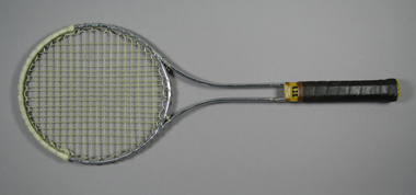
Racquet, Circa 1969
A Wilson 'T2000' metal tennis racquet, with double shaft; yellow plastic shaft casing & gold whipping. Handle wrapped with brown leather. Net anchored to metal wire wrapped around head frame. Yellow plastic butt cap with white label featuring 'W' logo in red. White plastic reinfrcement strip fixed around crown. Adhesive label inside shaft states: STRUNG WITH PRIDE & TLC/SOUTH COAST TENNIS & GOLF SHOPS. Materials: Metal, Plastic, Adhesive tape, Nylon, Adhesive label, String, Leathertennis -
 Kew Historical Society Inc
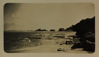
Photograph - Mouth of the Hopkins River, Point Ritchie, Warrnambool, c.1926
Henry Beater Christian (1886-1962) , was a descendant of one of the earliest settler families in Kew. Employed at the Kew Asylum as a 'public servant', he was a skilled amateur photographer, photographing numerous scenes in Kew and on his travels around Victoria. The majority of his photographs date from 1916 to 1929. His finest photographs are housed in two photograph albums. Digital copy of a photograph from page 23 of the 47-page photograph album containing 261 gelatinous silver images, loaned by Diane Washfold with permission given to digitise and hold a copy in our collection. Henry Christian took a number of walking and rail trips, individually or with friends, around regional and rural Victoria during the 1920s. This photo is from a series of twelve photographs of parts of the west coast of Victoria, including Port Fairy and Warrnambool. The location in this photograph has been identified by Kathleen Gervasoni as the mouth of the Hopkins River, Point Ritchie, Warrnambool. henry beater christian (1886-1962), landscape photography, christian-washfold collection, photograph albums, hopkins river, point ritchie, warrnambool -
 Kew Historical Society Inc
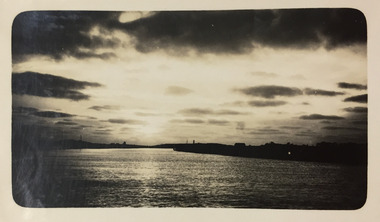
Photograph - River Moyne at Port Fairy, c.1926
Henry Beater Christian (1886-1962) , was a descendant of one of the earliest settler families in Kew. Employed at the Kew Asylum as a 'public servant', he was a skilled amateur photographer, photographing numerous scenes in Kew and on his travels around Victoria. The majority of his photographs date from 1916 to 1929. His finest photographs are housed in two photograph albums. Digital copy of a photograph from page 23 of the 47-page photograph album containing 261 gelatinous silver images, loaned by Diane Washfold with permission given to digitise and hold a copy in our collection. In the 1920s, the photographer travelled throughout Victoria, including on the west coast from Port Campbell to Port Fairy. Trips were presumably made by train and by foot. Lynda Tieman and her team at the Port Fairy Historical Society have tentatively identified a number of Henry Christian's photographs of Port Fairy, of which this is one. The scene is believed to be the River Moyne.henry beater christian (1886-1962), landscape photography, christian-washfold collection, photograph albums, river moyne, port fairy -
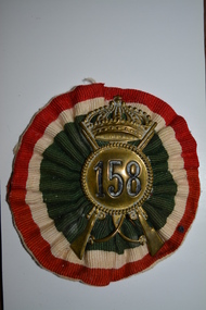 Wangaratta RSL Sub Branch
Badge - Hat Badge, Italian
Brass hat badges of the 158th Infantry Division Zara a regular infantry division of the Royal Italian Army and a garrison unit stationed on the Dalmation Coast during WW2. It surrendered to the Germans after the Italian surrender to the Allies in September 1943. Badges were often souvenired by Australian soldiers during WW2The 158th Infantry Division Zara was a regular infantry division of the Royal Italian Army during World War II. The Zara Division formed in March 1942, was a garrison division stationed on the Dalmatian coast. It surrendered to the Germans after the Italian surrender to the Allies in September 1943Two brass Italian Army hat badges showing crossed rifles and '158' within a rope circle surmounted by a crown. One badge is mounted on a red, white and green striped ribbon rosette 158ww2, italian army, badge -
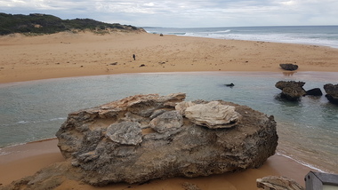
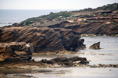 Ballarat Heritage Services
Digital photographs, Middle and Merri Islands Warrnambool, 2016
Digital images showing Middle Island and Merri Island, Warrnambool.landscape, seascape, geology, warrnambool, middle island, merri island, coast, coastal, thunderpoint -
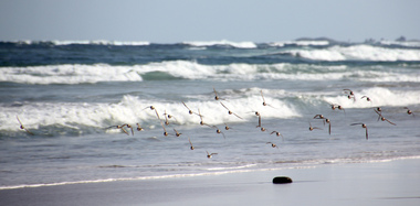 Ballarat Heritage Services
Photograph - Digital photographs, L.J. Gervasoni, Hooded Plovers Flying, Killarney Beach, 2015, c2015
Killarney Beach is located at the end of Mahoney's Road. It is sheltered from wave action by offshore reefs. Colour photograph of Hooded Plovers flying at Killarney Beach, Victoria. killarney beach, killarney, beach, coast, ocean, hooded plovers, birds, flying, seascape -
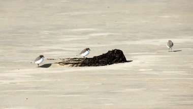 Ballarat Heritage Services
Digital photographs, L.J. Gervasoni, Hooded Plovers on the beach, c2015
killarney beach, killarney, beach, coast, ocean, hooded plovers, birds, seascape, seaweed -
 Ballarat Heritage Services
Digital photographs, L.J. Gervasoni, Hopkins River Mouth, c2010 - 2017
Three colour photographs of the mouth of the Hopkins River at Warrnambool.hopkins river, mouth, point ritchie, bluehole, warrnambool, coast, coastal, beach, seascape -
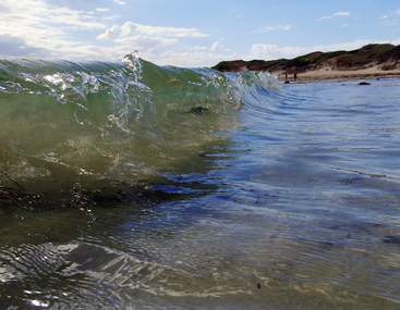 Ballarat Heritage Services
Photograph - Digital photographs, L.J. Gervasoni, Wavelet at Killarney Beach, 2016, c2016
Killarney Beach is located at the end of Mahoney's Road. It is sheltered from wave action by offshore reefs. Colour photograph of a wavelet at Killarney Beach.beach, wave, killarney, killarney beach, killarney, victoria, coast, ocean, seascape, landscape -
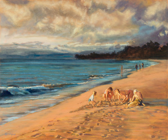 Bayside Gallery - Bayside City Council Art & Heritage Collection
Painting - oil on board, Thel Cardwell, Last light, 1992
This painting was entered into the Annual Brighton Art Exhibition in 1992 and was the winner of Brighton City Council Acquisitive Award category.Thel Cardwell, Last light 1992, oil on board, 74.8 x 90 cm Bayside City Council Art and Heritage Collection. Purchased 1992beach, coast, thel cardwell, last light, sand, children, recreation, brighton art exhibition, brighton rotary -
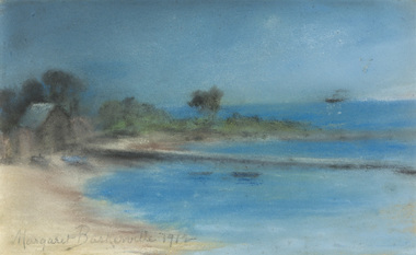 Bayside Gallery - Bayside City Council Art & Heritage Collection
Work on paper - pastel, Margaret Baskerville, Bathing box by beach, 1912
pastelbeach, coast, bathing box, margaret baskerville, bayside, port phillip bay, jetty, ship, bush -
 Bayside Gallery - Bayside City Council Art & Heritage Collection
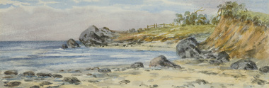
Work on paper - watercolour, Brighton Beach opposite Grimbley's Hotel
watercolourbrighton, beach, grimbley's hotel, coast, water, landscape, rocks, port philip bay, seascape -
 Bayside Gallery - Bayside City Council Art & Heritage Collection
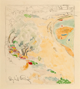
Work on paper - watercolour, Sybil Craig, Half Moon Bay, c.1930
Sybil Craig, Half Moon Bay c.1930, pencil and watercolour, 21 x 18.8 cm. Bayside City Council Art and Heritage Collection. Purchased 2020.half moon bay, sybil craig, bayside, coast, bathing box, bathers, black rock, boat, landscape -
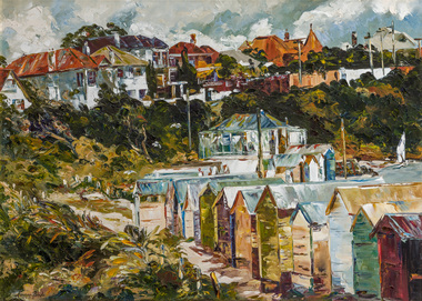
 Bayside Gallery - Bayside City Council Art & Heritage Collection
Painting - acrylic on canvas, Craig Gough, Sandringham 20, 1983
acrylic on canvassandringham, craig gough, bayside, half moon bay, coast, port phillip bay, sailing, landscape, sandringham band rotunda -
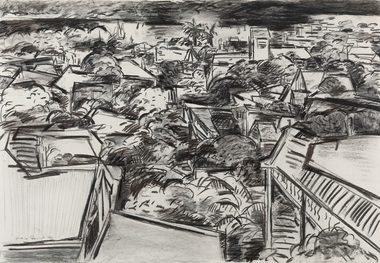
 Bayside Gallery - Bayside City Council Art & Heritage Collection
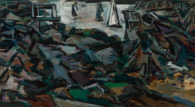
Work on paper - charcoal on paper, Craig Gough, Half Moon Bay (from 'Sandringham series'), 1983
charcoal on papersandringham, craig gough, coast, boat, port phillip bay, sailing, black rock jetty, pier, half moon bay -
 Bayside Gallery - Bayside City Council Art & Heritage Collection
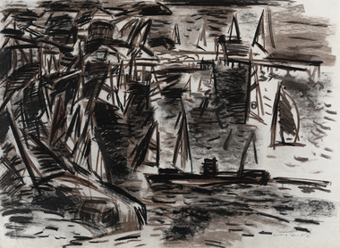
Work on paper - charcoal on paper, Craig Gough, To the Bay (from 'Sandringham series'), 1983
charcoal on papersandringham, craig gough, coast, boat, port phillip bay, sailing, half moon bay, roof tops, palm tree -
 Bayside Gallery - Bayside City Council Art & Heritage Collection
Painting - oil on canvas, Margery Boyle, Bathing Boxes, Brighton, c. 1978
bathing box, bathing shed, bathing boxes, brighton, brighton beach, beach, coast, port phillip bay, margery boyle -
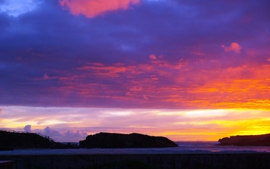 Ballarat Heritage Services
Photograph - Digital photographs, L.J. Gervasoni, Sunset Middle Island, Warrnambool, 2009-2012
Digital images of a sunset at Middle Island, Warrnambool. seascape, sunset, coast, coastal, landscape, middle island, merri island, stingray bay, warrnambool -
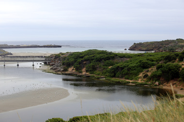 Ballarat Heritage Services
Photograph - Digital photographs, L.J. Gervasoni, Stingray Bay and the Mouth of the Merri River, 2016
Digital image of the mouth of the Merri River at Stingray Bay. landscape, seascape, geology, warrnambool, coast, coastal, stingray bay, merri river, mouth