Showing 10091 items matching "demolished"
-
 Kew Historical Society Inc
Photograph - High Street, Kew, 1960-65
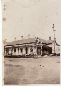
The borders of the main components of Kew and Kew East have not always conformed to current boundaries. In the past this photograph has been labelled as East Kew, whereas for most of the twentieth century the site has been within Kew's borders. The purpose of the photograph is unrecorded yet it has value in that it shows those businesses who occupied this site in Kew during the early 1960s.This small photograph is significant as it shows the location of and building used by WD Vaughan, former Mayor of Kew who was a successful newspaper proprietor in Melbourne.Small polaroid colour positive of High Street in Kew, probably in the 1960s. From left we can see the brick viaduct covering the tracks of what was once the Outer Circle Railway. Behind this brick wall, Dunnings Timber Yard was situated. At the end of the walls of the viaduct there is an entrance to a walkway [now the Anniversary Trail], which once provided access to Windsor Avenue, and also to the East Kew Station (now demolished and part of the Outer Circle Railway Reserve). On the other side of this walkway is a cream brick building (demolished) occupied at this time by WD Vaughan Pty Ltd, printer and publisher of the Kew Advertiser (newspaper). Stretching behind the brick facade is an extensive building that must have housed the printing works. Beside Vaughan's, there is a large building (demolished) housing at that time an estate agent named AJ Kennedy. This area is now separated by kerbing.High St East Kew / Corner of Harp Rd. / Looking South -
 Port Melbourne Historical & Preservation Society
Photograph - Bay Street, Port Melbourne, looking north, 1980s
Photo of Bay St, looking North, from beach side of Graham St. Photo shows TEAC building (later demolished), former National Bank building and warehouse and milk bar. Approx late 1980s or early 1990sbuilt environment - commercial, teac, bay street, national bank -
 Whitehorse Historical Society Inc.
Photograph, Whitehorse Hotel, 1935
Black and white photo of original Whitehorse Hotel being demolished. Situated on South East corner of Elgar Road and Whitehorse Road. White Horse was model for statue of Horse currently in median strip, Box Hill. Taken in 1935.atkinson, e., white horse hotel, white horse statue -
 Kilmore Historical Society
Photograph, 13 Sydney Street, 1970's?
Was the site of J. Quinn Bakery20cm x 12.5cm black and white photograph of the south side and rear of Breakells Bakery and shop. At the rear of the shop the wall was demolished in part to remove the oven from the bakery. On the second story of the back building a crude wooden door. Written on the back: 487 14-86-36bakers, bakeries, bakers and bakeries, bakery -
 Ringwood and District Historical Society
Photograph, Maroondah Highway West, Ringwood- 1962. Looking west from Town Hall
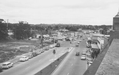
Black and white photograph (2 copies)Written on back of one photograph: "From Town Hall roof, Dec 1962. Image shows demolished site of Cool Stores on corner of Maroondah Highway and Wantirna Road. -
 Ringwood and District Historical Society
Photograph, Maroondah Highway Central, Ringwood. Ringwood Hall fronting Melbourne Street, Ringwood - 1936
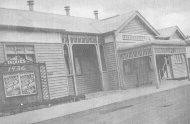
Taken 1936, advertising the Talkies, Melbourne St fronting, "look up and laugh"Written on backing sheet, "Ringwood Hall - later demolished and replaced by the Town Hall. Taken in 1936." Advertising board at front reads- Talkies, 1936. "Look Up and Laugh". -
 Bendigo Historical Society Inc.
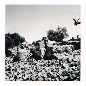
Photograph - PORTLAND HOUSE, GROWLER STREET, EAGLEHAWK
Photo: black and white photo of demolition of Portland House, Growler Street. Appended notes state ' Portland House, a wine house, owned by Cr. Babbage, demolished 1960.' Written on back of photo: ' The end of Portland House, Growler Street'cottage, miners, babbage, portland house, eaglehawk, growler street -
 Whitehorse Historical Society Inc.
Photograph, Whitehorse Hotel, 1935
(2) Black and white photos of original Whitehorse Hotel being demolished. South East corner of Elgar Road and Whitehorse Road. White Horse was model used for statue of Horse currently in median strip, Box Hill. Taken in 1935.atkinson, e., white horse hotel, white horse statue -
 Whitehorse Historical Society Inc.
Photograph, House, Queen Street Mitcham
Coloured print of a 110 slide of a house in Queen Street, Mitcham. (Not a good print - slide very dark) House is built of Australian Tesselated Tile Co., materials. Formerly the home of Raglans. Demolished c1974.|See also NP1214 - 17queen street, mitcham, australian tesselated tile co. pty ltd, raglans -
Canterbury History Group
Photograph - Soldiers Memorial Hall, Canterbury, [1925]
The Soldiers Memorial Hall was built in 1923 as a memorial to the soldiers of the First World War 1914-1918. The hall was demolished in 1979 and replaced by the Canterbury Memorial Home Units. A Roll Of Honour was at the left of the main entrance to the hall, this is now at the entrance to the units.canterbury, soldiers memorial hall, canterbury memorial home units, honour boards, canterbury road, halls -
 Eltham District Historical Society Inc
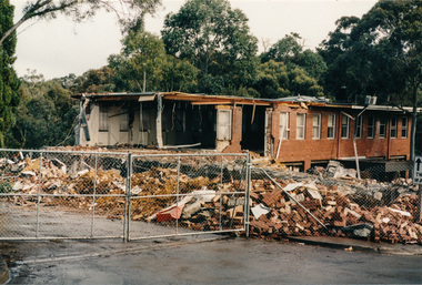
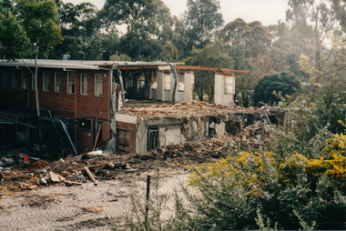
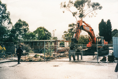
Photograph, Demolition of Eltham Shire Offices, 17 Aug 1996, 17/8/96
Three colour photographs of the Shire of Eltham Council Offices, Main Road, Eltham being demolished. 17 August, 1996. This followed Victorian Local Government re-amalgamations in 1994. This was a multi-story building which also included the Eltham Library.shire of eltham, demolition, buildings -
 Eltham District Historical Society Inc
Photograph, Demolition of Eltham Shire Offices, 17 Aug 1996, 17/8/96
Three colour photographs of the Shire of Eltham Council Offices, Main Road, Eltham being demolished. 17 August, 1996. This followed Victorian Local Government re-amalgamations in 1994. This was a multi-story building which also included the Eltham Library.shire of eltham, demolition, buildings -
 Bendigo Historical Society Inc.
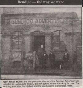
Newspaper - JENNY FOLEY COLLECTION: OUR FIRST HOME
Bendigo Advertiser "The way we were" from 1999. Our first home: the first permanent home of the Bendigo Advertiser was situated in Hargreaves Street, directly behind where the Addy is now. The building was later demolished and the site became Cambridge Press.newspaper, bendigo advertiser, the way we were -
 Villa Alba Museum
Photograph - Exterior wall, c.1987
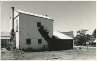
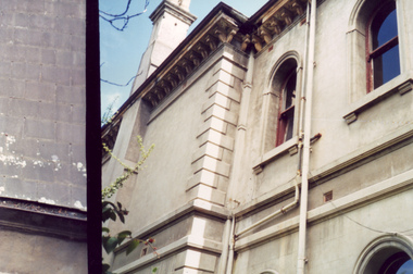
Built for William and Anna-Maria Greenlaw in the early 1880s, and with interiors decorated by the Paterson Bros, Villa Alba remained in private ownership until 1949. From 1950, the house was owned by a number of institutions. By 1984, the Villa Alba Preservation Society had been formed, and three years later, the Mount Royal Hospital granted a 25-year lease to Kew Council. In 2004, the title to Villa Alba was passed by the Victorian Government to The Villa Alba Museum Incorporated. The Museum, at 44 Walmer Street, Kew, is now a cultural institution committed to the collection, study and display of 19th century interior decorative finishes, and the components of 19th and 20th century interior decoration.This is one of a number of historically and aesthetically significant photos of the interiors and exterior of Villa Alba when it was still owned by the Mount Royal Hospital, showing twentieth century accretions and deterioration of the historic fabric of the building. This was a benchmark survey against which future conservation and restoration activities can be measured.In December 1987, Mockridge Stahle & Mitchell Pty Ltd Architects prepared ‘Villa Alba Survey: A Report on the fabric for Mount Royal Hospital’ of which this photograph is a part. Photo of exterior walls of Villa Alba with added building, later demolished, at left.villa alba museum, conservation photographs, victorian architecture, cement render -
 Mt Dandenong & District Historical Society Inc.
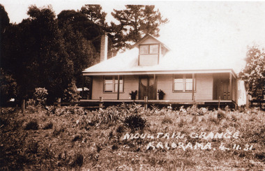
Photograph, Mountain Grange Kalorama 4.11.31, 4/11/1931
House in photo is handsome, well maintained with ornamental double doors and dormer window. Narrow view of rear of building. Picture does not resemble earlier photos but Mountain Grange demolished in 1932. Present location of the Karwarra Gardens and Kalorama Memorial Reserve.kalorama memorial reserve, mountain grange -
 Kew Historical Society Inc
Slide - 'St Helliers', 152-54 Edward Street, 1979
One of a group of slides taken by members of the Society of built heritage in Kew in 1979-80. The selection of subject matter reflects the priorities of the period. The colour of some slides has degraded.The slides represent a snapshot in time of built architecture in Kew, much of which has changed in the forty-plus period since they were created.Colour positive transparency (slide) of St Helliers, 152-54 Edward Street , Kew. St Helliers was the home of the Dumaresq family, one of the original crown lands sale purchasers in the district. Also known as 'The Grange', it was built in 1889 and demolished in 1982. historic houses -- kew (vic.), dumaresq family, st helliers -- 152-154 alfred street -- kew (vic.), st helliers -
Canterbury History Group
Ephemera - An opportunity awaits, 77 Highfield Road Canterbury, 2007
Real estate brochure for the sale of 77 Highfield Road Canterbury by auction on 7 July 2007. Includes a coloured photograph of the exterior and floor and site plan. Also a note by Robin Kelly that the property was sold for $1.3 million (September 2007) to be demolished.canterbury, highfield road, edwardian style -
 Lakes Entrance Historical Society
Photograph, Lakes Post Newspaper, 1991
Newspaper article appeared in Lakes Post 28 August 1991Black and white photograph showing Graham Ellis demolishing a residence at 37 Carpenter Street, formerly lived in by Viv and Tommy Harbeck. During demolition many old newspapers were found. Site was redeveloped as residential units. Lakes Entrance Victoriahouses, historic site -
 Kew Historical Society Inc
Photograph - 'Fernhurst', 13 Fernhurst Grove, 1978
George Wharton arrived in Melbourne in 1844. An architect and surveyor, he was appointed to lay out the 'Village of Kew' by N.A. Fenwick following the land sales of 1851. A protagonist for Kew's separation from the Boroondara District Road Board, he was elected chairman when Kew achieved municipal status in December 1860. His home, 'Fernhurst', was built in 1866 on eight acres in Studley Park, with a four-storey tower and pyramidal roof. The Italianate home was a prominent Kew landmark. It was demolished in 1979 and replaced by St Paul's College in 1980.Rare colour photograph of what was once a significant mansion in Kew.Original colour positive photograph (Kodak print) of 'Fernhurst' in 1978. Photographed by Stewart West in May 1978, one year before it was demolished, the photograph gives little idea of the large landholding once surrounding the house. Originally accessed from near the corner of Princess Street and Studley Park Road, its gardens had been subdivided in the 1900s and its footprint restricted to 13 Fernhurst Grove. Like many other grand houses, by the 1970s it had been converted into apartments. From the photograph, one can see that the house had retained many of its original features such as the distinctive tower and the wide bow-fronted verandah. The slates on the roof (apart from those on the tower) had been replaced by tiles and the cement render of the exterior painted white. Annotated reverse: "View of Fernhurst Home Taken from Street / 10"fernhurst, 13 fernhurst grove -- kew (vic.), george wharton, italianate architecture, vila maria society, st paul's school for the blind -
 Kew Historical Society Inc
Photograph - 'Fernhurst', 13 Fernhurst Grove, 1978
George Wharton arrived in Melbourne in 1844. An architect and surveyor, he was appointed to lay out the 'Village of Kew' by N.A. Fenwick following the land sales of 1851. A protagonist for Kew's separation from the Boroondara District Road Board, he was elected chairman when Kew achieved municipal status in December 1860. His home, 'Fernhurst', was built in 1866 on eight acres in Studley Park, with a four-storey tower and pyramidal roof. The Italianate home was a prominent Kew landmark. It was demolished in 1979 and replaced by St Paul's College in 1980.Rare colour photograph of what was once a significant mansion in Kew.Original colour positive photograph (Kodak print) of 'Fernhurst' in 1978. Photographed by Stewart West in May 1978, one year before it was demolished, the photograph gives little idea of the large landholding once surrounding the house. Originally accessed from near the corner of Princess Street and Studley Park Road, its gardens had been subdivided in the 1900s and its footprint restricted to 13 Fernhurst Grove. Like many other grand houses, by the 1970s it had been converted into apartments. From the photograph, one can see that the house had retained many of its original features such as the distinctive tower and the wide bow-fronted verandah. The slates on the roof (apart from those on the tower) had been replaced by tiles and the cement render of the exterior painted white. Annotated reverse: "Fernhurst from higher ground level side shot / 7"fernhurst, 13 fernhurst grove -- kew (vic.), george wharton, italianate architecture, vila maria society, st paul's school for the blind -
 Kew Historical Society Inc
Photograph - 'Fernhurst', 13 Fernhurst Grove, 1978
George Wharton arrived in Melbourne in 1844. An architect and surveyor, he was appointed to lay out the 'Village of Kew' by N.A. Fenwick following the land sales of 1851. A protagonist for Kew's separation from the Boroondara District Road Board, he was elected chairman when Kew achieved municipal status in December 1860. His home, 'Fernhurst', was built in 1866 on eight acres in Studley Park, with a four-storey tower and pyramidal roof. The Italianate home was a prominent Kew landmark. It was demolished in 1979 and replaced by St Paul's College in 1980.Rare colour photograph of what was once a significant mansion in Kew.Original colour positive photograph (Kodak print) of 'Fernhurst' in 1978. Photographed by Stewart West in May 1978, one year before it was demolished, the photograph gives little idea of the large landholding once surrounding the house. Originally accessed from near the corner of Princess Street and Studley Park Road, its gardens had been subdivided in the 1900s and its footprint restricted to 13 Fernhurst Grove. Like many other grand houses, by the 1970s it had been converted into apartments. From the photograph, one can see that the house had retained many of its original features such as the distinctive tower and the wide bow-fronted verandah. The slates on the roof (apart from those on the tower) had been replaced by tiles and the cement render of the exterior painted white. Annotated reverse: "Back view of Fernhurst / 8"fernhurst, 13 fernhurst grove -- kew (vic.), george wharton, italianate architecture, vila maria society, st paul's school for the blind -
 Kew Historical Society Inc
Photograph - 'Fernhurst', 13 Fernhurst Grove, 1978
George Wharton arrived in Melbourne in 1844. An architect and surveyor, he was appointed to lay out the 'Village of Kew' by N.A. Fenwick following the land sales of 1851. A protagonist for Kew's separation from the Boroondara District Road Board, he was elected chairman when Kew achieved municipal status in December 1860. His home, 'Fernhurst', was built in 1866 on eight acres in Studley Park, with a four-storey tower and pyramidal roof. The Italianate home was a prominent Kew landmark. It was demolished in 1979 and replaced by St Paul's College in 1980.Rare colour photograph of what was once a significant mansion in Kew.Original colour positive photograph (Kodak print) of 'Fernhurst' in 1978. Photographed by Stewart West in May 1978, one year before it was demolished, the photograph gives little idea of the large landholding once surrounding the house. Originally accessed from near the corner of Princess Street and Studley Park Road, its gardens had been subdivided in the 1900s and its footprint restricted to 13 Fernhurst Grove. Like many other grand houses, by the 1970s it had been converted into apartments. From the photograph, one can see that the house had retained many of its original features such as the distinctive tower and the wide bow-fronted verandah. The slates on the roof (apart from those on the tower) had been replaced by tiles and the cement render of the exterior painted white. Annotated reverse: "Fernhurst front view taken from across Fernhurst Grove / 6"fernhurst, 13 fernhurst grove -- kew (vic.), george wharton, italianate architecture, vila maria society, st paul's school for the blind -
 Kew Historical Society Inc
Photograph - 'Fernhurst', 13 Fernhurst Grove, 1978
George Wharton arrived in Melbourne in 1844. An architect and surveyor, he was appointed to lay out the 'Village of Kew' by N.A. Fenwick following the land sales of 1851. A protagonist for Kew's separation from the Boroondara District Road Board, he was elected chairman when Kew achieved municipal status in December 1860. His home, 'Fernhurst', was built in 1866 on eight acres in Studley Park, with a four-storey tower and pyramidal roof. The Italianate home was a prominent Kew landmark. It was demolished in 1979 and replaced by St Paul's College in 1980.Rare colour photograph of what was once a significant mansion in Kew.Original colour positive photograph (Kodak print) of 'Fernhurst' in 1978. Photographed by Stewart West in May 1978, one year before it was demolished, the photograph gives little idea of the large landholding once surrounding the house. Originally accessed from near the corner of Princess Street and Studley Park Road, its gardens had been subdivided in the 1900s and its footprint restricted to 13 Fernhurst Grove. Like many other grand houses, by the 1970s it had been converted into apartments. From the photograph, one can see that the house had retained many of its original features such as the distinctive tower and the wide bow-fronted verandah. The slates on the roof (apart from those on the tower) had been replaced by tiles and the cement render of the exterior painted white. Annotated reverse: "Front view of Fernhurst showing tower to advantage / 9"fernhurst, 13 fernhurst grove -- kew (vic.), george wharton, italianate architecture, vila maria society, st paul's school for the blind -
 Kew Historical Society Inc
Photograph - 'Fernhurst', 13 Fernhurst Grove, 1978
George Wharton arrived in Melbourne in 1844. An architect and surveyor, he was appointed to lay out the 'Village of Kew' by N.A. Fenwick following the land sales of 1851. A protagonist for Kew's separation from the Boroondara District Road Board, he was elected chairman when Kew achieved municipal status in December 1860. His home, 'Fernhurst', was built in 1866 on eight acres in Studley Park, with a four-storey tower and pyramidal roof. The Italianate home was a prominent Kew landmark. It was demolished in 1979 and replaced by St Paul's College in 1980.Rare colour photograph of what was once a significant mansion in Kew.Original colour positive photograph (Kodak print) of 'Fernhurst' in 1978. Photographed by Stewart West in May 1978, one year before it was demolished, the photograph gives little idea of the large landholding once surrounding the house. Originally accessed from near the corner of Princess Street and Studley Park Road, its gardens had been subdivided in the 1900s and its footprint restricted to 13 Fernhurst Grove. Like many other grand houses, by the 1970s it had been converted into apartments. From the photograph, one can see that the house had retained many of its original features such as the distinctive tower and the wide bow-fronted verandah. The slates on the roof (apart from those on the tower) had been replaced by tiles and the cement render of the exterior painted white. Annotated reverse: "Fernhurst corner shot through trees / 12-22"fernhurst, 13 fernhurst grove -- kew (vic.), george wharton, italianate architecture, vila maria society, st paul's school for the blind -
 Federation University Historical Collection
Photograph - Colour, Ballarat School of Mines Brewery Building, 2011, 17/11/2011
The Ballarat School of Mines Brewery Complex was built on the site of the former Ballarat Brewery. The Cowley's Eureka Iron Works boilers remain from the brewery era.A number of colour photographs of exterior and interior the The Ballarat School of Mines Brewery Complex was built on the site of the former Ballarat Brewery. Two photographs show the Cowley's Eureka Iron Works boilers which were used at the Ballarat Brewery before it was closed and demolished.ballarat school of mines, brewery complex, brewery building, cowley's, eureka ironworks -
 Bendigo Historical Society Inc.
Photograph - PHOTO OF SANDHURST POST OFFICE. 1861, 1861
Black and white photo of Sandhurst Post Office Bendigo. View street. 1861. This building opened June 1858 and was demolished 1867. A new Post Office was built on same site. The building behind the lamp is the Shamrock Hotel. People standing out front.place, building, post office -
 Surrey Hills Historical Society Collection
Photograph, Demolition of Tower House Day and Boarding School, Surrey Hills in 1932 (2), 20/08/1932
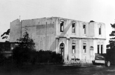
This building dated back to the 1880s and had previously operated as Delany's Hotel and then the Royal Hotel. It was built near the site of the original Delany's Hotel, built in 1856. The Royal Hotel closed in 1921 after the area voted to be a 'dry area'. Tower House Day and Boarding School operated from 1921 until 1932. Norman Carter took many photos of Surrey Hills and Mont Albert from the 1920s; many were associated with events and activities of the Church of England.Black and white photo of a partially demolished building. The roof is missing and there is a pile of rubble along the front wall. What remains indicates that it has been a large building in the Victorian style. There is a mixture of treatments to the surrounds of the windows. On the RHS part of a truck can be seen.Original: Top LH corner in blue biro "see matching photo"; top RH corner "498 / spare"; bottom LH corner in lead pencil "N Carter"; bottom RH corner in blue biro "20-8-32" - all Jocelyn Hall's handwriting.tower house day and boarding school, schools, education, royal hotel, hotels, construction and demolition, dry area, licensing polls, temperance movement, delany's hotel, norman carter -
 Whitehorse Historical Society Inc.
Photograph - Coloured Photograph, Narmara Primary School, 13/01/1994 12:00:00 AM
Coloured photo of Narmara Primary School looking East from North West corner, showing site of removal of school buildings. School on North side of Highbury Road between Middleborough Road and Blackburn Road. Since demolished and site developed for housing.narmara primary school, warner, philip -
 Ringwood and District Historical Society
Photograph, Maroondah Highway East, Ringwood- 1914. Mr. O.J. Pratt's butcher shop under construction, cnr Main Street and Warrandyte Road
Black and white photograph (2 copies)Typed below photograph: "Mr. O.J. Pratt's butcher shop being constructed corner Warrandyte Rd. and Main St. (Demolished for road widening) 1914. Site became C.B.C. Bank.