Showing 12220 items
matching historical museum
-
 The Beechworth Burke Museum
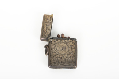
Functional object - Vesta Case, Unknown
This detailed example of a match holding Vesta was owned by someone with the initials GBW but is otherwise difficult to identify ownership. Vestas are the historical name for what are now known as matches. They were named for the Roman goddess Vesta whose domain was the hearth and home. The Swan company began production of short matches, mostly useful for lighting pipes and cigarettes due to their deliberately short length. Due to their small size it became convenient to carry these Vestas within a Vesta Case kept somewhere on the person, large enough to contain enough matches for a days use. The cases prevented their contents from becoming damaged and damp while also stopping them from accidentally striking if held loose in a pocket. This example of a Vesta case is particularly ornate.The social history objects held in the Burke Museum's collection help to tell the stories of Beechworth's past by showing the social, cultural, and economic aspects of the town's history.A decorative silver coloured vesta or match book. It has detailed engraving across the obverse and reverse sides with delicate scrollwork and a monogram set in a circular setting in the centre. The vesta has a hinged top and side loop to allow for attachment.GBW/ A01171/burke museum, vesta case, vesta, matches, silver, social history, luxury -
 The Beechworth Burke Museum
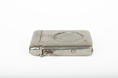
Functional object - Vesta Case, Unknown
Vestas are the historical name for what are now known as matches. They were named for the Roman goddess Vesta whose domain was the hearth and home. The Swan company began production of short matches, mostly useful for lighting pipes and cigarettes due to their deliberately short length. Due to their small size it became convenient to carry these Vestas within a Vesta Case kept somewhere on the person, large enough to contain enough matches for a days use. The cases prevented their contents from becoming damaged and damp while also stopping them from accidentally striking if held loose in a pocket. This is a simple example of a Vesta Case.The social history objects held in the Burke Museum's collection help to tell the stories of Beechworth's past by showing the social, cultural, and economic aspects of the town's history.A decorative silver coloured vesta or match book. It has a raised crosshatch pattern in a circular pattern on the obverse side. The vesta has a hinged top and side loop to allow for attachment.A01199/burke museum, vesta case, vesta, matches, silver, social history -
 The Beechworth Burke Museum
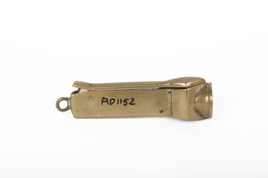
Tool - Cigar Cutter, Unknown
The exact creation of this Cigar Cutter is unknown, however the vintage nature and style of this cutter indicate that it was made in the early to mid 20th century. This cutter closely resembles the V-cut style of cigar cutter. These cutters are the most common type of cigar cutters and have been historically widely used. They cut a 'wedge' into the cigar cap rather than removing the whole cap like guillotine cutters do. This type of cut allows the smoker to get a deep cut into the V shaped cigar. Social history objects held in the Burke Museum help to tell the stories of Beechworth's past by showing the town's social, artistic and cultural community. This cutter shows significance through it's vintage artistic style and it's ability to show the social habits within Beechworth's history. A small bronze metallic cigar cutter with cigar insert on one side of the object and handle on the other side. A01152beechworth museum, cigar cutter, bronze, burke museum, social history -
 Camperdown & District Historical Society
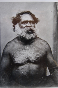
Photograph - Wombeetch Puyuun (Camperdown George), c1874
When he died at Camperdown in February 1883, Wombeetch Puyuun, also known as 'Camperdown George', was the last member of the Liwira Gundidj clan of the Djargurd Wurrung, still living on Country.Black and white photograph of Wombeetch Puuyun (Camperdown George)Back: XP 1924 Museum Victoriacdhs, wombeetch puyuun, djargurd wurrung, djargurdwurrung, cdhsfirstnations -
 Camperdown & District Historical Society
Photograph - Chest plate "King George Colungulac", c1860s
In the early days of colonial Australia the governors and the land holders saw advantage in singling out certain First Nations people as leaders and distinguishing them in some way. This chest plate was issued to "King George" of the Koenghegulluk Clan of the Djargurd Wurrung whose Country was near Lake Colongulac. This chest plate is inscribed "King Colungulac" and is held in the Museum Victoria collection. ""King George"" is pictured wearing the chest plate in a photograph of First Nations people at Framlingham Mission in 1867.Colour photograph of brass chest plate inscribed "KING GEORGE COLUNGULAC" Front: "KING GEORGE COLUNGULAC"; Back: XP49214 Museum Victoriabreast plate, cdhs, cdhsfirstnations -
 Orbost & District Historical Society
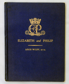
book, Elizabeth and Philip, January 1, 1947
This is a short study of Princess Elizabeth and Lieutenant Philip Mountbatten, written expressly to coincide with their wedding. It tells some of the stories behind the Royal romance as well as sketching the personalities and characters of the young Royal couple. The book probably belonged to Mary Gilbert, a prominent member of the Orbost community - a teacher and historian who was the first curator of the Orbost Museum. This book is a useful reference tool.A 64 pp dark blue hardback book with gold print on the cover - ELIZABETH and PHILIP and underneath a gold line - LOUIS WULFF, M.V.O. It contains b/w photographs and stories of Princess Elizabeth and Lieutenant Philip Mountbatten. It is authored by Louis Wulff, M. V. O.Inside front cover - in brown pencil - Gilbertsroyal-family princess-elizabeth gilbert-mary -
 Orbost & District Historical Society
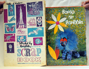
scrapbooks, Gilbert, Mary, 1960's
Belonged to Mary Gilbert who was a passionate local historian. She was awarded a British Empire medal in recognition of her work for education and the community. . Mary Isabelle Gilbert was born in 1905 in Orbost, Australia. She was born to John Gilbert and Annie Cameron Gilbert, and had seven sisters and one brother. Four siblings died at a young age. .She was a teacher historian loved and respected by her family and the wider community.Mary Gilbert was the first curator of the Orbost Museum, and a local teacher. These scrapbooks contain articles which reflect the social standards of the 1960's.Two scrapbooks containing pasted in cut-out magazine articles on manners, presentation and clothes for young women.Handwritten on the front cover of 1840.1 : Words of Wisdomgilbert-mary scrapbooks 1960's -
 Orbost & District Historical Society
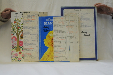
scrap books, Gilbert, Mary, 1960's
Belonged to Mary Gilbert who was a passionate local historian. She was awarded a British Empire medal in recognition of her work for education and the community. .Mary Isabelle Gilbert was born in 1905 in Orbost, Australia. She was born to John Gilbert and Annie Cameron Gilbert, and had seven sisters and one brother. Four siblings died at a young age. .She was a teacher historian loved and respected by her family and the wider community. Mary Gilbert was the first curator of the Orbost Museum, and a local teacher. These scrapbooks contain articles which describe historical events of the 1960's.Three scrapbooks containing clippings of newspaper articles of historical events. A list of contents is pasted on the front cover of each.Handwritten on the covers: 1842.1-Mary Gilbert Book1 ; 1842.2 - Mary Gilbert Book 2 ; 1842.3- Mary Gilbert Book 3gilbert-mary scrapbooks 1960's -
 Orbost & District Historical Society
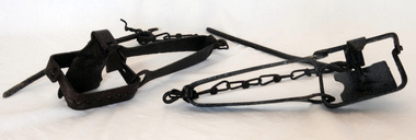
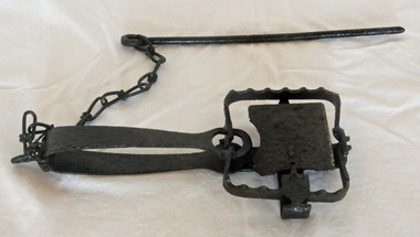
rabbit traps, First half 20th century
During the Great Depression from 1929 to 1932, rabbit trapping was a means of survival for many people. Rabbits provided meat and pelts which were sold for making felt hats such as the Akubra. Rabbit populations are controlled in the 21st century by poisoning, destroying or 'ripping' burrows (warrens), biological control with rabbit haemorrhagic disease and myxomatosis, and by shooting. Rabbit-proof fences also prevent the spread of rabbits into some areas. (ref. Powerhouse Museum) Steel-jawed rabbit traps were widely used in urban and rural Australia from 1880 to 1980. This trap is symbolic of the battle that Australians have waged against burgeoning rabbit populations for over a century. Rabbits cause enormous damage to Australian soils and biodiversity. The introduction of rabbits to this country was an environmental disaster.Two iron rabbit traps. Each consists of a pair of jaws held closed by spring tension and a triggering mechanism. When the trap is triggered the jaws close over the top of the bridge, plate and tongue mechanism that is designed to trigger the trap. A chain is attached by a hook on the bent end of the trap's spring with a long steel spike looped over the last link of the other end of the chain. The trap is designed so that the metal jaws snap shut against each other when the trap is activated by the application of weight to the pressure plate. In use, traps are set with open jaws, buried lightly just below the surface of the earth. When an animal steps on the pressure plate, the jagged teeth of the jaws snap around the animal's leg, usually breaking bone and sinew. Thus the animal is immobilised.rabbits rural trapping -
 Orbost & District Historical Society
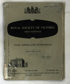
magazine, Royal Society of Victoria Proceedings, 29 January 1969
The Royal Society of Victoria was formed in 1859 from a merger between The Philosophical Society of Victoria and The Victorian Institute for the Advancement of Science, both founded in 1854. The first president of the Royal Society was Baron Sir Ferdinand von Mueller, then Government botanist. In 1860 the R.S.V. organised the Burke and Wills expedition. The Society has played an important role in the life of Melbourne and Victoria including establishing the Melbourne Museum and National Parks, convening the first Australian Antarctic Exploration Committee in 1885, organising the Burke and Wills expedition and establishing the Victorian Institute of Marine Sciences in 1978. The Royal Society of Victoria has published articles of scientific interest in the Proceedings of the Royal Society of Victoria annually since 1854. The aim of the Proceedings magazine is to contribute to the advancement of science by enhancing the knowledge and appreciation of science and technology and their impact on society. This magazine is a useful research tool.A 148 pp magazine, Royal Society of Victoria Proceedings - East Gippsland Symposium Vol 82 Part 1 - 29 Jan 1969. It contains a series of scientific articles pertaining to East Gippsland. The Proceedings of the Royal Society of Victoria is a refereed journal, published annually. The front cover is grey with black text. At the top is the royal coat of arms. Below that is the title Royal Society of Victoria Proceedings in white print on a black background. On the bottom left is a black drawing of the Royal Society of Victoria building.Stamped twice on front cover is ORBOST HIGH SCHOOLscience-research-east gippsland royal-society-of-victoria -
 Orbost & District Historical Society
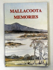
book, Mallacoota Memories, 1980
This book was produced by the Mallacoota and District Historical Society. The Society, founded in 1974, has a museum housed in a World War 2 Bunker in Mallacoota . The bunker was handed over to the Society by the R.S.L.A small 104 pp book titled Mallacoota Memories. On the front cover is a coloured photo of lakes and trees. The title is in red. The book contains early observations by J.[G] A. Robinson; contact with settlers; mentions Biduelli, Kruatungulung, Murring, Ben- Kurnai, Mallekotang Mittong, Tinnon, Kyrekong, Ponedyang, Worarer Mittong groups. The history is from 1841 -1945. It was produced by Mallacoota and District Historical Society.mallacoota-history robinson-j.a -
 Orbost & District Historical Society
rabbit trap, first half 20th century
During the Great Depression from 1929 to 1932, rabbit trapping was a means of survival for many people. Rabbits provided meat and pelts which were sold for making felt hats such as the Akubra. Rabbit populations are controlled in the 21st century by poisoning, destroying or 'ripping' burrows (warrens), biological control with rabbit haemorrhagic disease and myxomatosis, and by shooting. Rabbit-proof fences also prevent the spread of rabbits into some areas. (ref. Powerhouse Museum) This trap was used in the Orbost district. Steel-jawed rabbit traps were widely used in urban and rural Australia from 1880 to 1980. This trap is symbolic of the battle that Australians have waged against burgeoning rabbit populations for over a century. Rabbits cause enormous damage to Australian soils and biodiversity. The introduction of rabbits to this country was an environmental disaster.A rusted iron rabbit trap which consists of a pair of jaws held closed by spring tension and a triggering mechanism. When the trap is triggered the jaws close over the top of the bridge, plate and tongue mechanism that is designed to trigger the trap. A chain is attached by a hook on the bent end of the trap's spring with a long steel spike looped over the last link of the other end of the chain. The trap is designed so that the metal jaws snap shut against each other when the trap is activated by the application of weight to the pressure plate. In use, traps are set with open jaws, buried lightly just below the surface of the earth. When an animal steps on the pressure plate, the jagged teeth of the jaws snap around the animal's leg, usually breaking bone and sinew. Thus the animal is immobilised. rabbit-trap rural -
 Orbost & District Historical Society
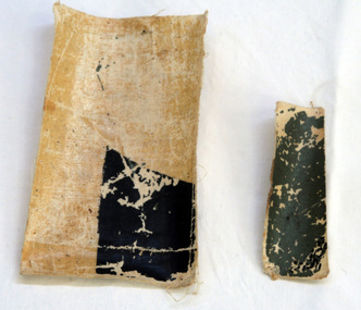
war souvenir
These pieces of canvas are from a German plane brought down by an allied fighter. The pilot was shot through the head. It was given to Mary Gilbert by Alex P. Cameron to be donated to the museum.This item is a reminder of the personal stories of WW1.Two small pieces of canvas from a German plane brought down by another fighter. It is part of a black cross on the plane. There is hand-written information written on the back of both pieces.souvenir ww1 -
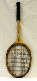 Orbost & District Historical Society
tennis racquet, 1930-1940
The tennis racquet belonged to John Phillips who used it in the late 1950s / early 1960s. It was not a new racquet when Ihe started using it, but a pass-me-down from his father. He purchased his first new racquet in the mid 60s and gave this racquet to the Orbost Museum to go in the racquet press so that people would have an idea of what the item (press) was used for - to stop wooden framed racquets with gut strings from warping. John played tennis at Orbost Tennis Club from 1969-1981 - vice president 1971-77, president 1977-81, secretary of Orbost & District Tennis Association 1975-81. He is a Life Member of the Orbost Tennis Club (1980). John is also a Life Member of the Orbost & District Historical Society.This item is an example of an early piece of sports' equipment which was manufactured using different materials.A wooden tennis racquet with a reinforced cane handle. The handle has a black leather grip. The frame is wooden ash with gut strings.ALL ENGLAND Genuine Weather Proof SLAZENGER Reinforced Cane Sealed finishtennis-raquet sport recreation phillips-john orbost-tennis-club -
 Orbost & District Historical Society
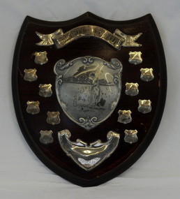
shield
First croquet committee in Orbost started up in 1919. (ref : The Whos' Who of Orbost Settlers - Mary Gilbert). Often croquet lawns were in private gardens eg. at Connort (now Moogji)..This shield is part of the history of the Orbost Croquet Club. In the museum, there is also an old copy of the rules of Croquet, a mallet and a photo of the first committee.A wooden shield. The Dorothy Andrews Handicap Singles Memorial Shield for the Orbost Croquet Club. There are smaller metal shields for the names of the winners.Names on the shields are: Amy Gall; Gwen Reynolds; Ann Nixon; Don Herbert; Ann Kerr; Ella Evans; May Herbert; Izy Trewin; Maisie Nixon; Millie Leatham; Dot Eatoncroquet recreation leisure trophy -
 Orbost & District Historical Society
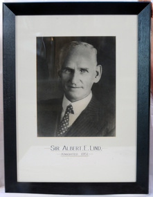
framed photo, APFA- Davisigns (PG & ME Davis)
This photo was inherited with the building when the museum was established. Lind was born in 1878 in East Charlton, Victoria, the son of Oliver Nicholas Lind, a farmer from Denmark, and his Welsh wife Mary Ann Clay. In 1882, drought forced the family to move to East Gippsland where Lind was educated at Lucknow, and then to Bairnsdale in 1884 where he attended Bairnsdale state school. In October 1920, he was elected to the Victorian Legislative Assembly for the seat of Gippsland East for the Victorian Farmers' Union. Lind was made Minister of Forests, President of the Board of Land and Works and Commissioner of Crown Lands and Survey in Albert Dunstan's cabinet. He was knighted in 1951. In 1926 two national parks east of Orbost were named the Albert and the Lind national parks after him.A framed photo of Sir Albert Eli Lind. It is a black and white head and shoulders photo in a black wooden frame.Sir Albert E. Lind Knighted !951photograph politician lind-albert government -
 Orbost & District Historical Society
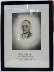
framed photograph, APFA- Davisigns (PG & ME Davis)
This photo was inherited when the Orbost Museum was established in its present building. R.G.Davey was the Orbost Shire Engineer from 1922 -1930,Secretary and Engineer from 1930-1937 and Shire Engineer in 1938.A framed photo, head and shoulders of R.G. Davey. It is a black and white photo in a black wooden frame with a label on the back.R.G.Davey Shire Engineer 1922-1930 Secretary & Engineer 1930-1937 -Shire Engineer-1938municipal shire-engineer davey-r.g. orbost-shire-council -
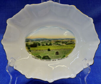 Orbost & District Historical Society
dish, 1950-1970
Small china pieces carrying scenic views of holiday destinations were a popular kind of souvenir during much of the 20th century. The pictures on the souvenirs ranged across natural beauty spots (beaches, waterfalls, rivers), civic buildings and monuments (town halls, war memorials), and indicators of local progress (commercial centres and occasionally even industrial sites). Ref: Powerhouse Museum Sydney.Small souvenir dish. White with gold edging and a picture of Orbost in bottom centre. Picture is a view from Grandview Heights. White, square, bone china dish with fluted rim trimmed with gold. In the centre of the dish there is a coloured transfer of a scene labelled as 'Sturt Street, Ballarat'. The scene shows grand Victorian buildings in the background, shops with verandahs and verandah posts lining one side of Sturt Street, trees on the other side of the street, and a tram in the foreground. A transfer on the underside gives manufacturer's information. Read more: http://www.powerhousemuseum.com/collection/database/?irn=12118#ixzz23rwkysrO Under Creative Commons License: Attribution Non-CommercialUnderneath- Royal Stafford -Bone China, Made in England, 3444 Top- Orbost From Grandview Heights, Vic.souvenir dish orbost grandview-heights crockery domestic stafford-royal -
 Orbost & District Historical Society
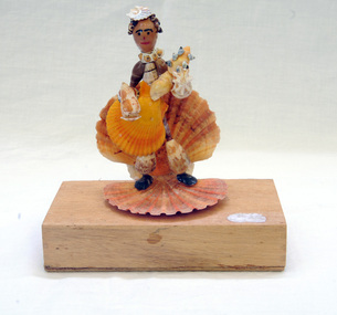
shell ornament, c. early to mid 20th Century
Mrs Elma Camm (nee Freeman) was the wife of Herbert Desmond Camm. Des and Elma lived in Orbost from 1971-1980/1. Des died on 9/11/1980 and is buried in Orbost Cemetery. Elma moved away and is presently (2013) in care at Lakes Entrance. Elma's hobby was collecting shells and crafting them into interesting forms. Much of her work is in the Shell Museum in Lakes Entrance. The figurine in Orbost Museum was donated by Elma.This item is an example of the handcraft skills of women in the early to mid 20th century.A small figurine made completely of different shaped shells and set onto a wooden block as its base. The block was originally a Wee William cigar box. The figure is playing a stringed instrument, possibly a guitar, held in front of him/her. The hat is a small shell.shell-art figurine recycled-materials -
 The Beechworth Burke Museum
Photograph, Unknown
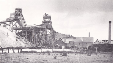
The A1 Gold Mine is located north of Woods Point, near Jamieson, in the Upper Goulburn region of Victoria. Gold was discovered at the A1 site in 1861 and mining operations began in 1864. The A1 Mine Settlement refers to a small township known variously as Castle Reef, Castle Point, and Raspberry Creek, which developed in the 1860s around mining industry centred on a crushing machine that worked the three gold reefs in the area. Historically, the name "A1"referred to the high quality of gold found in the quartz reefs at depths of at least two thousand feet. Along with the Morning Star mine at Woods Point, the A1 gold mine produced almost sixty percent of Victoria's gold output in the 1950s to 1970s and continued operating until 1992 when it went into administration. Operations at the site were revived in 2016 and the A1 Mine is now considered one of Victoria's premier gold mines. The A1 mine is part of the extensive and prospective Lachlan Fold Belt, a north-west trending belt of tightly folded Early Devonian sedimentary rocks extending from New South Wales to Victoria. Mineralisation is hosted within or immediately adjacent to diorite dykes. Contemporary development of the 'Queens Lode' at the A1 mine signals a move from high-grade, narrow vein airleg mining into larger scale, mechanical mining designed to increase ore production volume. This original, undated photograph of the A1 Mine appears to depict an area or phase of disuse or abandonment. The aged and humble appearance of the cottage suggests association with the historical A1 Mine Settlement, therefore the image may have been taken prior to the 1950s-1970s revival period in which the A1 mine is known to have produced high gold yields. The photograph contributes to our understanding of the A1 Gold Mine's impact on the landscape and the social, environmental impacts of mining on communities and may be compared with others in the Burke Museum's extensive collection of mining photographs to deepen our understanding of mining in the Jamieson area.Black and white rectangular photograph printed on photographic paperReverse: 5577 / A1 Mine / Near Jamieson / Vic. /burke museum, beechworth museum, beechworth, gold fields, gold rush, victorian gold rush, mining tunnels, gold ming history, colonial australia, australian gold rushes, mining technology, beechworth historic district, indigo gold trail, indigo shire, upper goulburn shire, jamieson, woods point-walhalla goldfield, a1 gold mine, victorian high country, modern mining methods, orogenic gold province, gold mineralisation, devonian, dykes -
 The Beechworth Burke Museum
Photograph - Photograph - Reproduction
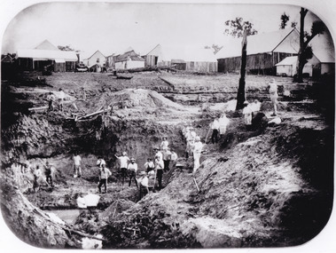
After gold was discovered to be deposited "for miles along Woolshed Valley" in the early 1850s, the Woolshed became a major site of mining activity in the north-east . This region was divided into large claims of 80 yards long, one of which was the one depicted in this photograph, called 'Big Johnson's Claim'. Claims such as this utilised a range of technology, including water wheels, steam engines, sluices and toms, most of which would not arrive until after 1856 when this photograph was taken. The Woolshed initially became prosperous in 1855, and labourers, such as the ones depicted in this photograph, engaged in sinking work for 7 pounds a week, whilst other mining labourers could earn up to nine. The search for gold is ingrained into the history of Victoria and therefore, images like this one which portray an open cut sluicing site can reveal important information for society and technology for the date when the photograph was taken. This image is of important historical significance for its ability to convey information about the operations of mining claims, particularly of the Woolshed Valley area that this photograph documents. This image is important for current research into the history of Woolshed, which was a major site of mining significance and operations. Therefore, this image has the capacity to be beneficial for research into society and the motivations of those living and working in this region during this period and therefore, has social significance. The Beechworth Burke Museum has additional images relating to gold sluicing and the Woolshed area which can be analysed and studied alongside images like this one. A black and white rectangular photograph printed on matte photographic paper.Reverse: 7791 / page 34. / 52% / Big Johnstone / Claim on Woolshed Goldfields / 1856 / Note canvas [illegible] building / Burke Museum /woolshed, mining, claims, mining claims, big johnson, gold -
 The Beechworth Burke Museum
Photograph - Photograph - Reproduction
This photograph depicts the Great Southern Mine located in Rutherglen as it was during the 1900. After the initial Gold Rush of 1853-1854, Gold was discovered deeper under the surface of the earth in the 1860 after the discovery of another deep lead system. Due to the discovery of Gold in Rutherglen, Rutherglen developed into a community in its own right, possessing a population of 6600 by December 1860 and developed into a municipality in 1862. The Great Southern Mine depicted in this photograph required the use of a range of modern technologies, including the hydraulic pumps, in order to reach gold. This photo depicts the mining operations as they were undertaken around the turn of the century.The search for gold is ingrained into the history of Victoria and therefore, images like this one which portray a modern mining operation undertaken in the 1860s, can reveal important information for society and technology for the date when the photograph was taken. This image is of important historical significance for its ability to convey information about the methods used to extract gold in 1900. It is significant as most mining operations around the region, particularly earlier on in the period, used different technologies such as water races. This image is important for current research into the history of Rutherglen more generally, a town which developed singlehandedly due to the discovery of minerals and mining, as depicted here in this photograph, thus indicating an element of social significance as well as historic. The Beechworth Burke Museum has additional images relating to mining and Rutherglen which can be analysed and studied alongside images like this one.A black and white rectangular photograph printed on matte photographic paper.Reverse: $ 3.00 19972503 / a02503 / Great Southern Mine Rutherglen 1900rutherglen mine, rutherglen, great southern mine, beechworth, mine, mining, post goldrush, victoria, gold, 1860s, sluicing, hydrolic sluicing -
 The Beechworth Burke Museum
Photograph
The photograph, captured around 1900, depicts a large group of minors located in Beechworth. Importantly, this photograph can provide information into the clothing and fashion of minors during this period of history. These men wear loose fitting shirts which are mostly a pale white colour, several wear vests and/or jackets and loose fitting trousers with boots. The majority of men wear wide brimmed hats to protect their skin and eyes from the sunlight. One man has a wooden pipe in his mouth and a few have ties/neckerchief's tied around their necks. The outfits of these miners has the potential to provide insight into their social status, these men are all dressed equally which provides the notion that they are of equal societal standing. The outfits of these miners dating to the 1900s is not dissimilar to photographs of those captured in the 1880s. The location of this photograph is not easy to interpret, but the photograph is recorded to have been taken in the Beechworth region. Displayed in this image is some wild shrubbery and grass where the men are standing/sitting and behind the group is a tin wall or even tin building. At the end of 1899, companies were continuing to search for gold in Beechworth and the surrounds but these attempts were not overly successful. In the early 1900's Quartz mining was occurring but this was done by individuals or smaller parties. It is unclear if these men are mining for gold or for quartz.The search for gold is ingrained into the history of Victoria and therefore, the study of images like this one which portrays some of the miners who worked behind-the-scenes for these discoveries has the potential to reveal important information regarding society, fashion etc. The date when the photograph was taken is vague but it allows us to form a timeline of mining activities in the North East. This image is of important historical significance for its ability to convey information about society at the time, regarding fashion (which can potentially reveal social status) and mining in Beechworth in 1900. Black and white rectangular photograph printed on matte photographic paper mounted on board.Reverse: BMM 8032/ Group(?) Beechworth Mines about 1900/ 80quartz, north east gold, sluicing, gold sluicing, hydraulic sluicing, mining, gold mining, north-east victoria, beechworth, burke museum, 1900, group, miners, hats, vests, ties, wild shrubs, tin, quartz mining -
 The Beechworth Burke Museum
Photograph - Photograph - Reproduction, Unknown
This image is a reproduction of an 1899 original depicting the 'Williams Good Luck Mine' on the Mopoke Reef (also called 'Morepork Gully') in the Dingle Ranges, approximately three miles from Beechworth. The foreground of the image is littered with piles of smashed rock and detritus, known as ‘mullock’, beside a reinforced mine shaft, a vertical access passageway allowing miners to enter the mine and haul ore out using lifting technology such as a poppet heads, whims or windlasses. A group of miners and a dog appear close to an open-sided miner’s hut. Following the discovery of gold at Beechworth in 1852, rushes quickly followed at surrounding creeks and gullies in the district. In the late nineteenth and early twentieth centuries, small syndicates of miners continued to work old or abandoned quartz reefs, often persisting without the assistance of heavy machinery to remove the large amounts of rock, in order to obtain yields at ever greater depths. The group of miners in this photograph are Mr. Roger Williams and Sons, who revived operations at the ‘Old Good Luck’ mine on the Mopoke Reef in the Dingle Range near Beechworth around 1892, working the site for more than two decades. An emigrant from Cornwall with experience in the tin mining industry, 19 year old Roger Williams senior sailed to New Zealand in 1840, then to Australia where he spent time in the Bendigo Gold Fields before settling in Beechworth in the early 1860s. Mr Williams senior worked on various mining activities in the district, including the Rocky Mountain Tunnel project. Conversant with the character of gold-bearing reefs in the area, the syndicate dug an eight hundred foot tunnel, digging down as far down as two hundred feet with little capital save their labour, to connect and provide better working access to the mass of reefs and veins in the vicinity. Progress was hampered by poor air quality charged with fumes from dynamite and large quantities of rock had to be crushed to obtain payable yields. The Victorian Goldfields are filled with ruins and remnants of the area's rich mining history, ranging from small alluvial diggings to the remains of huge mining companies. Site names often changed several times throughout the nineteenth and twentieth centuries. Some sites were abandoned and forgotten, others were worked continuously over many decades. The names of mines were often repeated at different locations throughout the Victorian Goldfields. For example, there is a Mopoke Gully heritage mine near Fryers Creek, Victoria. 'Mopoke' is a common onomatopoeic name for Morepork and Australian Boobook owls. This image has historical, social and research significance for patterns of emigration during of the Victorian Gold Rush, and the historical, social and environmental impacts of mining at Beechworth at the turn of the nineteenth and twentieth centuries. As gold became scarce and government support and large company investment waned, poor hard-working miners laboured intensively to make a living through periods of high unemployment. This image can be compared and studied alongside other historical mining photographs and objects in the Burke Museum Collection. It has potential to improve our understanding of miners working conditions and the shifting character of mining in the Beechworth district. Black and white rectangular reproduction photograph printed on matte photographic paper.Obverse: Williams Good Luck Mine Beechworth / Roger! / Reverse: 6858 / burke museum, beechworth museum, beechworth, gold fields, gold rush, victorian gold rush, gold ming history, colonial australia, australian gold rushes, mining technology, beechworth historic district, indigo gold trail, migration, indigo shire, good luck gold mine, victorian goldfields, mining syndicates, gold fever, quartz-mining, small-scale mining, old good luck mine, mopoke gully, quartz reefs beechworth -
 The Beechworth Burke Museum
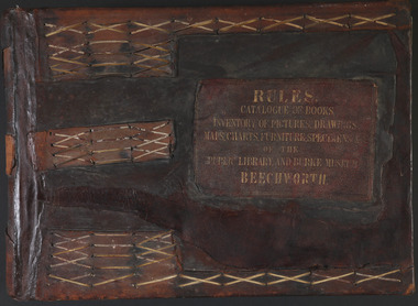
Book - 1875 Catalogue, William Detmold, RULES / CATALOGUE OF BOOKS / INVENTORY OF PICTURES, DRAWINGS, / MAPS, CHARTS, FURNITURE, SPECIMENS / OF THE / PUBLIC LIBRARY AND BURKE MUSEUM / BEECHWORTH, 1875
This large, leather bound journal was made for the Public Library and Burke Museum in Beechworth by book manufacturer, William Detmold in 1875. It was commissioned by the President of the Library and Burke Museum committee, Dr Antoine Mousse, for the purpose of cataloguing all the items in the collection. The cataloguer was the curator at that time, William Morton, whose hand-writing appears in the journal today. When William Morton first started recording in this journal in 1875, there were already a number of existing items in the institution. The Public Library and Burke Museum in Beechworth had actually been operating since the 1850s; first as a Young Men’s Association in 1856, then as Beechworth Athenaeum in 1858, then as the Beechworth Public Library in 1860. Then in 1861 when news of the death of Beechworth’s former police superintended, Robert O’Hara Burke, reached the town, it was agreed that the Public Library would also become a museum to tribute his legacy, renaming it as the ‘Public Library and Robert O’Hara Burke Memorial Museum, Beechworth’. Many of the items from the early institutions would have been used to form the nucleus of this new organisation. Plus, the additional items that were either collected or donated to develop it into a museum. The catalogue is extensive. There are exactly 461 pages of recorded items, each page detailing the various collections the museum acquired in the late 19th century. Collections recorded in this catalogue include a large collection of geological specimens, that were given to the museum in 1868 by the Geological Survey Department of Victoria. A large collection of taxidermy mounts, that were given to the museum as skins by the Museum of Australia in 1865. An extensive collection of Aboriginal artefacts that were purchased from amateur anthropologist R. E . Johns in 1868. As well as artworks, charts, photographs, machinery, maps etc., all of which have been held in the museum since. This catalogue also details the governance and management of the organisation. There were originally 30 rules that governed the actions for the management committee and, while anyone could read in the free library, only subscribers could borrow two books and one periodical. At first, subscriptions rates were 7/6 a quarter. This was later changed to £1 per annum, paid quarterly in advance. This was a considerable amount; 7/6 per quarter meant that the annual fee was £1.10. This was equivalent to about £650.00 or about $1,182.00AUD today, while the reduced subscription fee of £1 a year was the equivalent to £450.00 or about $818.00AUD today. Membership of the athenaeum would have been the reserve of the town's notable citizens. The vale of the catalogue lies not only in its historical connect with the establishment of the Athenaeum and the current museum, but also in its record of the names and positions of all members of the institution's committees of management from 1875-1876. This is a unique object that contains important records for a notable country town. Large brown leather bound book made in 1875 for the Beechworth library and museum by William Detmond. Inside is a comprehensive and detailed itemised listing of the paintings, drawings, charts, photographs, specimens and books that entered the institution from 1850 -1882. non-fictionCover: RULES / CATALOGUE OF BOOKS / INVENTORY OF PICTURES, DRAWINGS, / MAPS, CHARTS, FURNITURE, SPECIMENS / OF THE / PUBLIC LIBRARY AND BURKE MUSEUM / BEECHWORTHburke museum, beechworth, catalogue, museum catalogue, 1875, william morton, william detmold, exposition universelle, ferdinand von mueller, public library, collection, book, leather bound, restored, digitised, robert o'hara burke, hand-written -
 The Beechworth Burke Museum
Photograph, 1920-1950
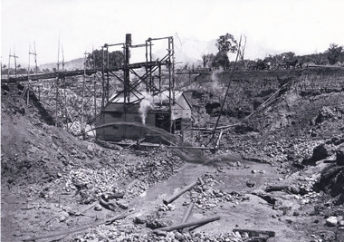
This image taken between 1920-1930 depicts open-cut hydraulic sluicing at the Three Mile Mine, located about five kilometres south of Beechworth. Alluvial, or surface, mining began on this site in the 1850s, but was soon replaced by hydraulic sluicing methods. By the start of 1880 it is estimated that nine hundred miles of water races had been cut though soil and rock in the Beechworth district. Hydraulic sluicing employs high pressure jets of water to blast away large areas of earth and wash it down to be run through a sluice box. Gold gets caught in the sluice and the remaining slurry is washed away. Large water quantities were required for hydraulic sluicing, and the long water races and deep tailraces that were constructed were considered great engineering feats. This method of mining is extremely effective, but causes significant environmental damage and impacts to waterways and agricultural operations. Miners at Beechworth built extensive networks of races and dams to secure reliable supplies of water on a scale far greater than elsewhere in Victoria. By the 1880s Beechworth's water barons continued to hold more than half of all the water right licences on issue and undertook sluicing operations on a massive scale. The manipulation of surface and ground water via race networks was well planned and recorded in detail by local mining surveyors. The maps that were created, combined with modern geo-spatial technologies, provide a vital key in understanding the great lengths to which miners went to capture and control critical water resources. Today, Three Mile mine is called Baarmutha. The Three Mile Mine was unproductive until 1865 when John Pund and three other miners secured a fifteen year license and constructed a water race from Upper Nine Mile Creek to Three Mile Creek. In the early twentieth century Pund & Co. averaged over one thousand ounces of gold per year from the mine. After Pund's death in 1915, GSG Amalgamated Co operated the site, continuing sluicing until 1950. This image of hydraulic sluicing methods shows the extent of water-works engineering in the landscape. This photograph has historic and research potential for understanding changes to the landscape, the evolution of mining methods, and the extensive construction, manipulation and management of water networks in the Beechworth district. Black and white rectangular photograph on matte paperReverse: 7597-1 / Sluice Mining / Copied from original on loan from Webb (Qld) / Donated Nov 2009 / Baarmutha Three Mile Mine c1920-1950 / Managed by the Plain Bros then Parkinsons / Current Location is: Beechworth Animal Shelter / used for Baarmuthaburke museum, beechworth museum, beechworth, gold fields, gold rush, victorian gold rush, hydraulic sluicing, spring creek, netwown falls, mining tunnels, water races, tailraces, gold ming history, colonial australia, australian gold rushes, mining technology, beechworth historic district, indigo gold trail, indigo shire, john pund, water manipulation, water engineering, three mile creek, three mile mine, water race, large-scale mining methods, historical mining construction, alluvial mining, mining environmental impacts, baarmutha, water barons -
 The Beechworth Burke Museum
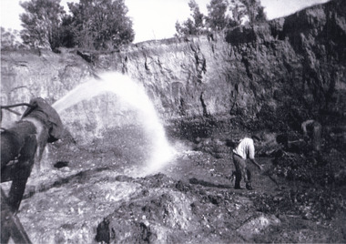
Photograph, Circa 1920 - 1950
Taken between circa 1920 - 1950 this photograph depicts a man dressed in dark trousers, a white long sleeved shirt and broad-brimmed workers hat digging around in the Three Mile Mine at Barramutha. The mine was an important gold resource and was typically mined using a method known as hydraulic sluicing whereby high powered water jets are used to dislodge rock or move sediment. The remaining water sediment slurry is directed through sluice boxes to remove the gold. The Beechworth mining district was one of six mining districts established by the governor-in-council on 4th of January 1858 under the provisions of An Act for Amending the Laws Relating to the Goldfields (21 Vic no. 32). This photograph shows historic and research value into the historical methods of hydraulic sluicing in the Beechworth mining disctrict. It also shows the evolution of the mining methods and has potential for understanding future engineering endeavors in the context of victorian mine goldfields. Black and white rectangular photograph printed on matte photographic paper.Reverse: 7597.3/ Copied from original on loan from Webb (QLD)/ Donated Nov 2009/ Barnawatha Three Mile Mine 1920-1950/ Owned by Plain Bros then Parkinsons/ Managed by John Weir, Peter Jenson, Jack Cox/ Slicing. three mile creek, three mile goldfields, three mile beechworth, goldfields, #beechworth, hydraulic mining, hydraulic sluice, burke museum -
 The Beechworth Burke Museum
Photograph, 1920 - 1930
Taken between circa 1920 - 1930 this photograph depicts a Hydraulic water jet in the foreground and a man dressed in dark trousers, a white long sleeved shirt and broad-brimmed workers hat digging around in the Three Mile Mine at Barramutha. The mine was an important gold resource and was typically mined using a method known as hydraulic sluicing whereby high powered water jets are used to dislodge rock or move sediment. The remaining water sediment slurry is directed through sluice boxes to remove the gold. The Beechworth mining district was one of six mining districts established by the governor-in-council on 4th of January 1858 under the provisions of An Act for Amending the Laws Relating to the Goldfields (21 Vic no. 32).This photograph shows cultural and research value into the historical methods of hydraulic sluicing in the Beechworth mining disctrict. It also shows the evolution of the mining methods and has potential for understanding future engineering endeavors in the context of victorian mine goldfields.Black and White rectangular photograph printed on matte photographic paper. Reverse: Copied from original on loan from Webb (QLD)/ Donated Nov 2009/ Barnawatha Three Mile Mine c1920-1950/ Owned by Plain Bros then Parkinsons/ Managed by John Weir, Peter Jenson, Jack Cox/ Slicing. three mile creek, three mile goldfields, three mile beechworth, goldfields, #beechworth, hydraulic mining, hydraulic sluice, burke museum -
 The Beechworth Burke Museum
Photograph, 1920 - 1930
Taken between circa 1920 - 1950 this photograph depicts the open mine in the Three Mile Mine at Barramutha. The mine was an important gold resource and was typically mined using a method known as hydraulic sluicing whereby high powered water jets are used to dislodge rock or move sediment. The remaining water sediment slurry is directed through sluice boxes to remove the gold. The Beechworth mining district was one of six mining districts established by the governor-in-council on 4th of January 1858 under the provisions of An Act for Amending the Laws Relating to the Goldfields (21 Vic no. 32).This photograph shows cultural and research value into the historical methods of hydraulic sluicing in the Beechworth mining disctrict. It also shows the evolution of the mining methods and has potential for understanding future engineering endeavors in the context of victorian mine goldfields.Black and White rectangular photograph printed on matte photographic paper.Reverse: Copied from original on loan from Webb (QLD)/ Donated Nov 2009/ Barnawatha Three Mile Mine c1920-1950 Minehead & Slicing/ Managed by John Weir, Peter Jensen, Jack Cox/ Owned by/ the Plain Bros then Parkinsons/ John worked for Pqarkinsons. three mile creek, three mile goldfields, three mile beechworth, goldfields, #beechworth, hydraulic mining, hydraulic sluice, burke museum -
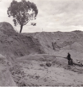 The Beechworth Burke Museum
Photograph
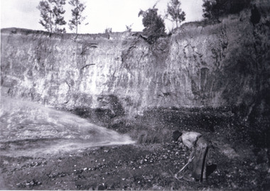
This photograph depicts a man in dark clothing, standing in front of a cut away section of earth. He is undertaking hydraulic sluicing, which involves the use of high powered hoses, in order to cut away the earth which can then be sifted for gold. There is a single tree in the background and the earth contains numerous signs of damage because of the mining. Beechworth become a mining settlement after the discovery of gold in 1852. Gold fever had already spread across Australia's colonies and the American states. Sluicing the landscape for gold, as shown in this photograph, was done by diverting water and washing away the lighter dirt, allowing the gold particles to sift down in to catchments for collection. In Beechworth, there was considerable discontent caused by attempts to restrict water use for sluicing to those with certain 'water rights'. The extensive use of hydraulic sluicing, and the washing away of top soils has continued to impact the surrounds of Beechworth in to the present day. Sluicing as a method for gold mining which was widespread across Victoria during the 1870s. The erosion of the top soil in search of gold has a continuing environmental impact on the landscape and this photograph depicts but one example of this occurring and can provide much information to a researcher interested in understanding the history of gold mining in Victoria. This image of the miner and hose is historically important because it demonstrates the methods of goldmining employed in the later years of the goldrush at Beechworth. It shows how much land is washed away by the use of this technology. The image has good interpretive capacity because it allows researchers to see a different mining technique to what is usually presented. Black and white square photograph on card.reverse: 84-50-3 / 1997 3141 / smdsluicing, goldmining, beechworth, burke museum, miners, gold miners, gold sluicing, environmental impact