Showing 623 items
matching landscape gardener
-
 Ballarat Tramway Museum
Photograph - Black & White Photograph/s - set of 2, mid 1972
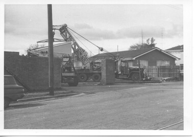
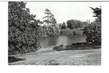
... Ballarat Tramway Museum South Gardens Reserve Wendouree ...Yields information about the construction of the depot building for the BTPS in the south Gardens Reserve and the landscape at the time.Black and white photograph of the bike or bicycle shed at the old SEC Depot Ballarat being lifted by a Bob Davies crane onto a truck for transport front the depot mid 1972 - part of the demolition work undertaken at the depot. Possibly one of the last buildings to be removed. trams, tramways, depot, bike shed, demolition -
 Bendigo Historical Society Inc.
Photograph - Glass Slide Photos of Bendigo, Early 1900s
Bendigo followed much the same pattern as Ballarat, and was not ready for an up-to-date studio until 1880 when the Bartlett Bros. (Francis and Henry) who bad conducted a successful business in Melbourne for many years opened a small studio there. It was such a success that they decided to build large modern premises, and Francis made two trips to England and the Continent for the latest ideas. In 1884 Henry died, and to replace him, Francis secured the services of Robert W. Bugg, then employed by Foster & Martin (both pupils of Batchelder's) in Collins Street, Melbourne. In that studio Bugg made some fine portraits of Anthony Trollope during the novelist's long tour of Australia. Francis Bartlett was a keen business man, and Robert Bugg was a great operator and a fine painter. Together, their success was quite outstanding. Fifteen years later Bartlett retired with a fortune, and Bugg took over the studio. Robert William Bugg, one of our leading Painter-Photographers, was born in London in 1853, and came to Melbourne when he was five years old. He became a pupil of Louis Buvelot and, in 1879, a member of the Victorian Academy of Arts. In Bendigo he gave annual exhibitions of his oils and water colours, a number of his exhibitions being officially opened by his friend Alfred Deakin. There are a number of Bugg's Paintings in the Bendigo Art Gallery. All the portraits, landscapes, buildings, and city views illustrated in "Bendigo and Vicinity, 1897", are from photographs taken by Robert Bugg. He was a clever, genial and popular soul, and his influence on the cultural life of his adopted city was considerable. He retired in 1932 and died in his early eighties.Eleven Photos of Bendigo from Glass Plate Negatives, Campaspe River at Axedale, Axe Creek, Lake Weroona, White Hills Botanical Gardens, Conseratory Gardens, Bendigo Fernery. Slides are ex Bartlett Brother Bendigo. history, bendigo, bendigo conservatory gardens, campaspe river axedale, axe creek victoria, lake weroona bendigo, white hills botanical gardens bendigo, bartlett brothers bendigo, rosalind park bendigo -
 Bendigo Historical Society Inc.
Document - Amy Huxtable Memorial History Prize Winners, 1992-93
Amy Huxtable was born at Cheltenham in 1918, to Robert Henry Huxtable and Violet a Dagg. Her father was an installer for an oil company and travelled the State. taking his family with him. She completed her education at the Bendigo High School and later attended the Bendigo Business College, becoming an expert shorthand writer. Her first position was as a copy writer with Radio 3BO, in the mid 1930s. She worked with an advertising agency in Melbourne and then with the Age,newspaper. In 1953, Miss Huxtable was appointed temporarily to succeed Miss E B Millane as social editress of the Bendigo Advertiser, during the latter's absence abroad. In 1956, Amy travelled abroad and on her return in 1957 was appointed permanently as Women's editor, a position she held for twenty-three ears. During her early years with The Advertiser she wrote under the name Toora, but in later years her own name became widely known. Miss Huxtable was well known both in her professional capacity and through a interest and involvement in community activites. She was life governor of the Bendigo Hospital, the Bendigo Home for the Aged, and Mirridong Home for the Blind, she was a member of Soroptimist International and the Business and Professional Women's Club. Amy was also a tireless worker for the spastic society and a strong supporter of the YWCA. When Amy Huxtable died at Mt AJvernia Hospital on 16 January 1980 Mayor Campbell ordered the city flag to be flown at half-mast. "Lowering the flag is the least we can do for such a lady" Cr Campbell said. Douglas Lockwood, editor of the Bendigo Advertiser said, "She was a devot d colleague who gave her craft and her newspaper the kind of service which identified a rare and generous spirit." She was a true professional who decided to make Bendigo her home. More than 300 people packed St Paul's Church for her funeral ervice the bell tolled as the casket was carried from the church. At a ceremony in the Conservatory Gardens on No ember 22 1981 The Amy Huxtable Memorial Committee presented to the City of Bendigo, a garden seat in memory of the late Miss Huxtable. This Bendigo manufactured seat was a fitting tribute to one ofBendigo's most loved and esteemed citizens. All Miss Huxtable's Advertiser articles were microfilmed and presented to the Library by the above committee. Amy Huxtable Memorial History Prize Winners for 1992 as announced in 1993 by the Bendigo Historical Society, Dudley House, View Street, Bendigo. * First Prize - Michael Jaeger. Paper: A reconstruction of the landscape of a portion of the Parish of Runnymede, Northern Plains, Victoria. * Highly Commended - Mrs Jeanette Margison. Paper: A review of pre-federation and post federation education, and the transitional changes that took place.history, amy huxtable, bendigo, amy huxtable memorial history awards -
 Ballarat Tramway Museum
Book, Keith Kings, "Bendigo's Vintage Talking Trams"
Book - "Bendigo's Vintage Talking Trams" - Edited by Keith Kings tells the story of Bendigo's trams from the battery tram days through to the operation by the Bendigo Trust. Includes the script of the Talking tram (Nov. 1996) and the tram fleet at the time. Has a table of contents, editor's notes and a colour map of the trip with script or talking points.Yields information about Bendigo's trams and that of the Bendigo Trust operations and fleet.Book - A5 landscape, 100 pages + card covers centre stapled, with some colour pages.bendigo, musuems, bendigo trust, keith kings, trams, tramways -
 Ballarat Tramway Museum
Postcard, Kookaburra and ?, Flinders St. Railway station
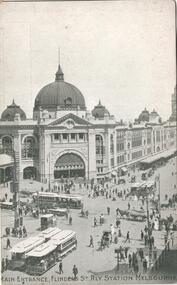
334.1 - Kookaburra Series No. 25 postcard, vertical format, view of the Swanston St entrance to Flinders St. Railway station with five sets of cable trams with horse drawn vehicles and many people. Photo is formally printed using a screen. Title 'Main Entrance, Flinders St. Rly Station Melbourne' along base. On rear in landscape format is areas for address, card number, a kookaburra symbol and saying, publisher notes and areas for address and correspondence. Off white card. c 1910. 334.2 - Photograph as a postcard of the Swanston St. entrance of Flinders St. Railway station from ground level with horse drawn vehicles and pedestrians in view. No motor cars in view or cable cars. c1910. On base in white ink (faded) handwriting 'Railway Station Melbourne'. On rear is name of object and areas for Address and Correspondence and '29'. trams, tramways, melbourne, flinders st. station, cable trams -
 Buninyong & District Historical Society
Photograph - B/W photograph, View of The Gong, old Brewery in the background, September 1993
... , recreational uses and local wildlife Botanic Gardens Brewery Landscape ...The Gong has been part of the Buninyong industrial, cultural and recreational history pre and post 1837Fed by springs, the Gong has been a major source of water for industrial, pastoral, recreational uses and local wildlifeBlack and white photograph of the Gong, view of the South East Corner with the Old Brewery in the backgroundbotanic gardens, brewery, landscape, industry, water supply, springs -
 Buninyong & District Historical Society
Photograph - B/W photograph, View of the Gong, April 1994
... , recreational uses and local wildlife Botanic Gardens Landscape Industry ...The Gong has been part of the Buninyong industrial, cultural and recreational history pre and post 1837Fed by springs, the Gong has been a major source of water for industrial, pastoral, recreational uses and local wildlifeBlack and white photograph of the Gong, view from Scott Street to the South West cornerbotanic gardens, landscape, industry, water supply, springs -
 Kew Historical Society Inc
Plan, Melbourne & Metropolitan Board of Works : Borough of Kew : Detail Plan No.1576, 1904
The Melbourne and Metropolitan Board of Works (MMBW) plans were produced from the 1890s to the 1950s. They were crucial to the design and development of Melbourne's sewerage and drainage system. The plans, at a scale of 40 feet to 1 inch (1:480), provide a detailed historical record of Melbourne streetscapes and environmental features. Each plan covers one or two street blocks (roughly six streets), showing details of buildings, including garden layouts and ownership boundaries, and features such as laneways, drains, bridges, parks, municipal boundaries and other prominent landmarks as they existed at the time each plan was produced. (Source: State Library of Victoria)This plan forms part of a large group of MMBW plans and maps that was donated to the Society by the Mr Poulter, City Engineer of the City of Kew in 1989. Within this collection, thirty-five hand-coloured plans, backed with linen, are of statewide significance as they include annotations that provide details of construction materials used in buildings in the first decade of the 20th century as well as additional information about land ownership and usage. The copies in the Public Record Office Victoria and the State Library of Victoria are monochrome versions which do not denote building materials so that the maps in this collection are invaluable and unique tools for researchers and heritage consultants. A number of the plans are not held in the collection of the State Library of Victoria so they have the additional attribute of rarity.Original survey plan, issued by the MMBW to a contractor with responsibility for constructing sewers in the area identified on the plan within the Borough of Kew. The plan was at some stage hand-coloured, possibly by the contractor, but more likely by officers working in the Engineering Department of the Borough and later Town, then City of Kew. The hand-coloured sections of buildings on the plan were used to denote masonry or brick constructions (pink), weatherboard constructions (yellow), and public buildings (grey). Development in the 20th century has irreparably altered that part of Kew represented in this plan. In the block bounded by Cotham Road, Charles Street, Wellington Street and Gellibrand; just one house standing in 1903 remains. This block included two of the most historic houses in Kew: ‘Ordsall’ (later ‘Southesk’) and ‘Madford’ (previously ‘Elm Lodge’). Ordsall was the home of the second chairman of Kew, John Halfey. It contained some of the most significant interior murals in Kew, created for Halfey by artists working for Cullen & Co. It was demolished in 1960 to make way for the Kew Civic Centre. Elm Lodge had been built for William Siddeley in ca. 1864. Arthur Septimus King purchased it in 1874. The lower paddocks of Madford were sold in 1905 by his wife to the Borough of Kew and, after landscaping by George and Thomas Pockett, opened as the Alexandra Gardens in 1908. Elm Lodge/Madford was in 1922 to become St. Anthony’s Home for Little Children before its subsequent demolition in the 1980s.melbourne and metropolitan board of works, detail plans, maps - borough of kew, mmbw 1576, cartography -
 Kew Historical Society Inc
Photograph - Double-fronted Edwardian Villa, c.1918
The Kew Historical Society's map collection includes a substantial number of real estate subdivision plans, mainly of Kew but also of surrounding suburbs in Melbourne. Most of the subdivision plans date from the 1920s and 1930s when the districts old homes and local farmland were being split up to accommodate residential growth in the postwar period. These early plans were assembled by a local firm, Jas R Mather & McMillan, which had an office in Cotham Road. Many of the plans, and sometimes photos, were annotated by the agents.Subdivision plans are historically important documents used as evidence for the growth of suburbs in Australia. They frequently provide information about when the land was sold as well as evidence relating to surveyors and real estate and financial agents. The numerous subdivision plans in the Kew Historical Society's collection represent working documents, ranging from the initial sketches made in planning a subdivision to printed plans on which auctioneers or agents listed the prices for which individual lots were sold. In a number of cases, the reverse of a subdivision plan in the collection includes a photograph of a house that was also for sale by the agent. These photographs provide significant heritage information relating house design and decoration, fencing and household gardens.The photograph may also be aesthetically significant depending on the importance of the photographic atelier.On the reverse of a subdivision plan of the Palmyra Estate (Kew) is a photograph of a double-fronted Edwardian villa. The weatherboard and stucco house with high brick chimneys provides a clear indication of the style of curtains and gardens in houses of the period. Holland blinds with lace inserts are used in the left front window. They are combined with long lace curtains. The garden, with its curved pathway is bordered with garden beds that include marguerite daisies and roses. Reflecting a new interest in the Australian landscape, tree ferns and ground ferns are planted closer to the house.houses - kew, architecture - edwardian, real estate photographs -
 Kew Historical Society Inc
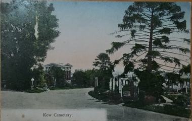
Postcard, Unknown, Kew Cemetery, 1905
This view of the Boroondara General (Kew) Cemetery is dated to 1905 by the inscription and postmark on the reverse. It provides an important visual record of this part of the Cemetery. The postcard can be used to identify the original configuration of the roads and vegetation, some of which was subsequently removed (eg the bunya pine at right). On the Victorian Heritage Database, the construction period given for the Springthorpe Memorial is given as 1897-1907, yet this view of the Memorial in 1905 would suggest that it was virtually completed at an earlier date. (It should be noted that additions such as the wheel of life sculpture were not completed until 1910).This dated photograph is historically important as its inscription confirms it to be one of the earliest postcard representations of the Boroondara General (Kew) Cemetery. It also provides visual evidence of the size and extent of the landscaping by 1905, particularly the layout of the roads (now altered), plantings of the period, and the extent of the land occupied by the Springthorpe Memorial and its gardens, which was subsequently reduced by the trustees of the cemetery in the 1930s. Panoramic view of the entrance driveway in Boroondara General (Kew) Cemetery. At left can be seen the Springthorpe Memorial, and further down on the left the entrance gate, or one of the gates, to the Memorial. Inscribed on reverse: "Miss Brown / Shuan [sic] / Grosvenor Street / M. Brighton. Love from Mother Oct 28th 1905" Postmark: "Melbourne 8 / 2 PM, 28/10/05".springthorpe memorial, boroondara general (kew) cemetery, postcards -- cemeteries -
Kew Historical Society Inc
Journal, Kewriosity : May 1988
Garden Party for Kew / p1. Calling landscape architects / p1. Dates for May p2. New production of 'Ten Times Tables' [The Hartwell Players] / p2. Scouts in Kew [4th Kew Scouts] / p2. Community education / p2. Commentary / Cr Jim Tutt [Prue Leggoe (Sibree), Jan Wade] / p3. Rates reminder / p3. Ron retires after 19 years with Kew [Ron Cook, Kew By-Laws officer] / p3. News from Kew Bicentennial Committee / p4. Notices / p4. Kew's only Bingo game / p4. Neighbourhood Watch / p4. Do you play scrabble / p4. Immunisation date for Kew / p4. Happy Easter from local bakery / p5. Kew Cottages wins Advance Australia award / p5. New [Kew Council] Ward names [Prospect, Sackville, Studley Park, Willsmere] p5. Kew Community House / Judy Price p6. Annoyed by noise? / p6. Top honours to Kew [Citizens'] Band / p6. Training sessions for voluntary literacy tutors / p6. Cast wanted [Viola Musical Comedy Society] / p6. Historical horse trough and hitching post restored / p7. History making service club [Kew Lioness Club] / p7. Mothers matter to [Kew Nursing Mothers] / p8. [Citizens' Ceremonies - Citizens Advice Bureau] / p8. Interested in 'Jack High' [Kew Bowling Club] / p8. Footy News [Kew Football Club] / p8.Kewriosity was a local newsletter combining Kew Council and community news. It was published between November 1983 and June 1994, replacing an earlier Kewriosity [broad] Sheet (1979-84). In producing Kewriosity, Council aimed to provide a range of interesting and informative articles covering its deliberations and decision making, together with items of general interest and importance to the Kew community and information not generally available through daily media outlets.non-fictionGarden Party for Kew / p1. Calling landscape architects / p1. Dates for May p2. New production of 'Ten Times Tables' [The Hartwell Players] / p2. Scouts in Kew [4th Kew Scouts] / p2. Community education / p2. Commentary / Cr Jim Tutt [Prue Leggoe (Sibree), Jan Wade] / p3. Rates reminder / p3. Ron retires after 19 years with Kew [Ron Cook, Kew By-Laws officer] / p3. News from Kew Bicentennial Committee / p4. Notices / p4. Kew's only Bingo game / p4. Neighbourhood Watch / p4. Do you play scrabble / p4. Immunisation date for Kew / p4. Happy Easter from local bakery / p5. Kew Cottages wins Advance Australia award / p5. New [Kew Council] Ward names [Prospect, Sackville, Studley Park, Willsmere] p5. Kew Community House / Judy Price p6. Annoyed by noise? / p6. Top honours to Kew [Citizens'] Band / p6. Training sessions for voluntary literacy tutors / p6. Cast wanted [Viola Musical Comedy Society] / p6. Historical horse trough and hitching post restored / p7. History making service club [Kew Lioness Club] / p7. Mothers matter to [Kew Nursing Mothers] / p8. [Citizens' Ceremonies - Citizens Advice Bureau] / p8. Interested in 'Jack High' [Kew Bowling Club] / p8. Footy News [Kew Football Club] / p8. publications -- city of kew (vic.), kewriosity, council newsletters, community newsletters -
Kew Historical Society Inc
Journal, Kewriosity : July 1984
Street trees in Kew [Carol Frank-Mas & Associates, Landscape Architects Report] / p1. Community [Gamblers Annymousl Action Programme; Save the Children Fund; Kew Garden Club; Native Plant Group; Kew Baptist Church; Hyde Park Fellowship; Film afternoon; Toy Library; Kew Junction Traders - advertising] / p2. Raoul Wallenberg Gardens / p3. Kew Recreation Centre / p3. Kew Historical Society / p3. Kew Community House / p4. Youth Pages [New Youth Centre for Kew; Unemployed? / p5. International Youth Year 1985 [What is it? So..., In Kew! Plans] / p6-7. [Youth] Talkback / p7. Things to do in Kew [&] A bit further afield [Kew Drop-in; After school activities; The Gap; Teen Club; Community House] / p8. Mayoral Comment - "Villa Alba" / Cr Jill O'Brien [Mayor of Kew] / p9. Community Directory updates / p9. Sahara Yoga [Centre] / p10. Community artists / p10. Highbury Grove Playgroup / p10. Kew Senior Citizens' Centre / p10. Powerlines and street trees / p11. Kindergarten enrolments / p11. Immunisation sessions / p11. Roadworks / p11. Drivers needed [Kew Community Bus] / p11. Domestic noise / p11. C.A.B. [Citizens' Advice Bureau] / p11. Kew (Daytime) Garden Club / p11. Kew people for nuclear disarmament / p11. H.K.C. Activities Centre / p11. Children's Services in Kew [Occasional Care Centre; Children's Services Officer; Full-Time Day Care Centre; Three Year Old Kindergarten; After School Programme; Extended Hours Kindergarten] / p12.Kewriosity was a local newsletter combining Kew Council and community news. It was published between November 1983 and June 1994, replacing an earlier Kewriosity [broad] Sheet (1979-84). In producing Kewriosity, Council aimed to provide a range of interesting and informative articles covering its deliberations and decision making, together with items of general interest and importance to the Kew community and information not generally available through daily media outlets.non-fictionStreet trees in Kew [Carol Frank-Mas & Associates, Landscape Architects Report] / p1. Community [Gamblers Annymousl Action Programme; Save the Children Fund; Kew Garden Club; Native Plant Group; Kew Baptist Church; Hyde Park Fellowship; Film afternoon; Toy Library; Kew Junction Traders - advertising] / p2. Raoul Wallenberg Gardens / p3. Kew Recreation Centre / p3. Kew Historical Society / p3. Kew Community House / p4. Youth Pages [New Youth Centre for Kew; Unemployed? / p5. International Youth Year 1985 [What is it? So..., In Kew! Plans] / p6-7. [Youth] Talkback / p7. Things to do in Kew [&] A bit further afield [Kew Drop-in; After school activities; The Gap; Teen Club; Community House] / p8. Mayoral Comment - "Villa Alba" / Cr Jill O'Brien [Mayor of Kew] / p9. Community Directory updates / p9. Sahara Yoga [Centre] / p10. Community artists / p10. Highbury Grove Playgroup / p10. Kew Senior Citizens' Centre / p10. Powerlines and street trees / p11. Kindergarten enrolments / p11. Immunisation sessions / p11. Roadworks / p11. Drivers needed [Kew Community Bus] / p11. Domestic noise / p11. C.A.B. [Citizens' Advice Bureau] / p11. Kew (Daytime) Garden Club / p11. Kew people for nuclear disarmament / p11. H.K.C. Activities Centre / p11. Children's Services in Kew [Occasional Care Centre; Children's Services Officer; Full-Time Day Care Centre; Three Year Old Kindergarten; After School Programme; Extended Hours Kindergarten] / p12. publications -- city of kew (vic.), kewriosity, council newsletters, community newsletters -
![Central Avenue, Fitzroy Gardens / [by] Nicholas Caire, circa 1876](/media/collectors/550653872162f11fb04854aa/items/57773e53d0cdd10a5c0ccd3b/item-media/57773f3fd0cdd10a5c0d358d/item-fit-380x285.jpg) Kew Historical Society Inc
Kew Historical Society IncPhotograph, Anglo-Australasian Photographic Company, Central Avenue, Fitzroy Gardens, c. 1876
Nicholas Caire was born on Guernsey in the Channel Islands in 1837. He arrived in Adelaide with his parents in about 1860. In 1867, following photographic journeys in Gippsland, he opened a studio in Adelaide. From 1870 to 1876 he lived and worked in Talbot in Central Victoria. In 1876 he purchased T. F. Chuck's studios in the Royal Arcade Melbourne. In 1885, following the introduction of dry plate photography, he began a series of landscape series, which were commercially successful. As a photographer, he travelled extensively through Victoria, photographing places few of his contemporaries had previously seen. He died in 1918. Reference: Jack Cato, 'Caire, Nicholas John (1837–1918)', Australian Dictionary of Biography.An original, rare photograph from the series 'Views of Victoria: General Series' by the photographer, Nicholas Caire (1837-1918). The series of 60 photographs that comprise the series was issued c. 1876 and reinforced a neo-Romantic view of the Australian landscape to which a growing nationalist movement would respond. Nicholas Caire was active as a photographer in Australia from 1858 until his death in 1918. His vision of the Australian bush and pioneer life had a counterpart in the works of Henry Lawson and other nationalist poets, authors and painters.Albumen Silver Photograph, mounted on Board.printed in ink on support l.c.: CENTRAL AVENUE, FITZROY GARDENS / COPYRIGHT REGISTERED. printed in ink on support reverse c.: VIEWS OF VICTORIA. / (GENERAL SERIES.) / No. 2. / CENTRAL AVENUE, FITZROY GARDENS. / The Fitzroy Gardens have, for several years past, become one of the most popular places for public resort- / attributable, no doubt, to the great variety of picturesque scenes they contain. Shrubs and flower plants, of almost / every description, can be seen growing in rich profusion within the enclosures, studded here and there with choice / pieces of statuary. The subject of the present illustration is but one of the many to be found within their precincts. / The distance of these gardens from the Melbourne Post Office is about one mile. printed in ink on support reverse l.c.l.: J.W. FORBES, Agent, printed in ink on support reverse l.c.: ANGLO-AUSTRALASIAN PHOTOGRAPHIC COMPANY, MELBOURNE. printed in ink on support reverse l.c.r.: 10 Temple Court, Collins Street West.nicholas caire (1837-1918), landscape photography -
![Scene in the Melbourne Botanical Gardens / [by] Nicholas Caire, circa 1876](/media/collectors/550653872162f11fb04854aa/items/577b5a2dd0cdd10948d09d9a/item-media/577b5a96d0cdd10948d0d84a/item-fit-380x285.jpg) Kew Historical Society Inc
Kew Historical Society IncPhotograph, Anglo-Australasian Photographic Company, Scene in the Melbourne Botanical Gardens, c. 1876
Nicholas Caire was born on Guernsey in the Channel Islands in 1837. He arrived in Adelaide with his parents in about 1860. In 1867, following photographic journeys in Gippsland, he opened a studio in Adelaide. From 1870 to 1876 he lived and worked in Talbot in Central Victoria. In 1876 he purchased T. F. Chuck's studios in the Royal Arcade Melbourne. In 1885, following the introduction of dry plate photography, he began a series of landscape series, which were commercially successful. As a photographer, he travelled extensively through Victoria, photographing places few of his contemporaries had previously seen. He died in 1918. Reference: Jack Cato, 'Caire, Nicholas John (1837–1918)', Australian Dictionary of Biography.An original, rare photograph from the series 'Views of Victoria: General Series' by the photographer, Nicholas Caire (1837-1918). The series of 60 photographs that comprise the series was issued c. 1876 and reinforced a neo-Romantic view of the Australian landscape to which a growing nationalist movement would respond. Nicholas Caire was active as a photographer in Australia from 1858 until his death in 1918. His vision of the Australian bush and pioneer life had a counterpart in the works of Henry Lawson and other nationalist poets, authors and painters.Views of Victoria (General Series) No.30 / ‘Scene in the Melbourne Botanical Gardens’ / Albumen silver photograph mounted on boardOn Reverse: ‘The Scene of the present illustration is taken from the Hill on the South Yarra side of the Gardens, shewing in the distance the Government Domain. In the centre of the picture a portion of the Lake may be seen. This Lake is of considerable extent, and being surrounded by hills, the slopes of which contain many beautiful Fern Groves and Vistas of the densest foliage, adds greatly to the beauty and picturesqueness of the surrounding scenery.’nicholas caire (1837-1918), australia - landscape photography -
![Scene in the Melbourne Botanical Gardens / [by] Nicholas Caire, circa 1876](/media/collectors/550653872162f11fb04854aa/items/57825c35d0cdd1176ce39a0a/item-media/57825c9fd0cdd1176ce3b5f0/item-fit-380x285.jpg) Kew Historical Society Inc
Kew Historical Society IncPhotograph, Anglo-Australasian Photographic Company, Scene in the Melbourne Botanical Gardens, c. 1876
... . nicholas caire (1837-1918) melbourne botanical gardens landscape ...Nicholas Caire was born on Guernsey in the Channel Islands in 1837. He arrived in Adelaide with his parents in about 1860. In 1867, following photographic journeys in Gippsland, he opened a studio in Adelaide. From 1870 to 1876 he lived and worked in Talbot in Central Victoria. In 1876 he purchased T. F. Chuck's studios in the Royal Arcade Melbourne. In 1885, following the introduction of dry plate photography, he began a series of landscape series, which were commercially successful. As a photographer, he travelled extensively through Victoria, photographing places few of his contemporaries had previously seen. He died in 1918. Reference: Jack Cato, 'Caire, Nicholas John (1837–1918)', Australian Dictionary of Biography.An original, rare photograph from the series 'Views of Victoria: General Series' by the photographer, Nicholas Caire (1837-1918). The series of 60 photographs that comprise the series was issued c. 1876 and reinforced a neo-Romantic view of the Australian landscape to which a growing nationalist movement would respond. Nicholas Caire was active as a photographer in Australia from 1858 until his death in 1918. His vision of the Australian bush and pioneer life had a counterpart in the works of Henry Lawson and other nationalist poets, authors and painters.‘Scene in the Melbourne Botanical Gardens’ : Views of Victoria (General Series) No.38 : Albumen silver photograph | Photo on card with Title and Description on reverse | Mounted 24 x 30 cm; Photo 12 x 17 cm.On Reverse: ‘The subject of this illustration is taken from near the Bridge, which crosses the Garden Lake. The grassy slope in the foreground of the picture is a portion of the North-West or Lower Lawn. Portions of the “Rockery” and the small lake can be seen in the mid-distance, near which is the new Rustic Summer-house. These Gardens are under the management of Mr. Guilfoyle, with about 20 assistant botanists, florists, and general gardeners.’nicholas caire (1837-1918), melbourne botanical gardens, landscape photography - victoria -
![Scene in the Carlton Gardens / [by] Nicholas Caire, circa 1876](/media/collectors/550653872162f11fb04854aa/items/57825eedd0cdd1176ce4cdaf/item-media/57825f52d0cdd1176ce50427/item-fit-380x285.jpg) Kew Historical Society Inc
Kew Historical Society IncPhotograph, Anglo-Australasian Photographic Company, Scene in the Carlton Gardens, c. 1876
... landscape photography - victoria On Reverse: ‘The Carlton Gardens ...Nicholas Caire was born on Guernsey in the Channel Islands in 1837. He arrived in Adelaide with his parents in about 1860. In 1867, following photographic journeys in Gippsland, he opened a studio in Adelaide. From 1870 to 1876 he lived and worked in Talbot in Central Victoria. In 1876 he purchased T. F. Chuck's studios in the Royal Arcade Melbourne. In 1885, following the introduction of dry plate photography, he began a series of landscape series, which were commercially successful. As a photographer, he travelled extensively through Victoria, photographing places few of his contemporaries had previously seen. He died in 1918. Reference: Jack Cato, 'Caire, Nicholas John (1837–1918)', Australian Dictionary of Biography.An original, rare photograph from the series 'Views of Victoria: General Series' by the photographer, Nicholas Caire (1837-1918). The series of 60 photographs that comprise the series was issued c. 1876 and reinforced a neo-Romantic view of the Australian landscape to which a growing nationalist movement would respond. Nicholas Caire was active as a photographer in Australia from 1858 until his death in 1918. His vision of the Australian bush and pioneer life had a counterpart in the works of Henry Lawson and other nationalist poets, authors and painters.‘Scene in the Carlton Gardens’ : Views of Victoria (General Series) No.40 : Albumen silver photograph | Photo on card with Title and Description on reverse | Mounted 24 x 30 cm; Photo 12 x 17 cm.On Reverse: ‘The Carlton Gardens are not so extensive as most of the other public gardens around Melbourne, and, being laid out on a flat piece of ground, have not the advantage of possessing much that is romantic in its scenery. The subject of this issue is the only interesting spot within the enclosure, which is the Rustic Fountain, surrounded by a small lake of water, on the banks of which grow some very beautiful specimens of the hanging willow. These Gardens are open to the public at all times.’nicholas caire (1837-1918), carton gardens, exhibition building, landscape photography - victoria -
 Kew Historical Society Inc
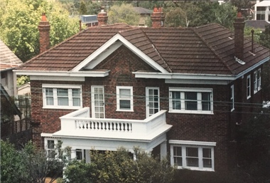
Photograph - 264 Cotham Road, 1988
The dwelling is representative of the development of the Georgian Revival style in the 1920s and 30s and its popularity amongst the upper-middle classes as a result of the work of William Hardy Wilson and Professor Leslie Wilkinson. It is of importance as a fine and largely intact designer/builder example of the Georgian Revival style, with American Georgian Revival influences. The dwelling embodies the principal characteristics of the style. American Georgian Revival influences are noted in the deep eaves with modillions, central broken pediment, brick quoins and presentation of the central porch. The garden wall, with arched opening, in the side setback appears to be an early or original landscape feature, based on the comparable brick work detail construction with that of the house. Considering this, it is the only early landscape feature extant which assists in providing some understanding of the original landscape layout of the property. (Criteria D and E) (Boroondara Planning Scheme)Colour photographic positive of 264 Cotham Road, Kew. The residence was constructed in 1931 for the Howitt family. 264 Cotham Road, Kew (HO813) is an individually listed building of significance under Amendment C294 of the Boroondara Planning Scheme. 264 cotham road -- kew (vic.) -
 Brimbank City Council Art Collection
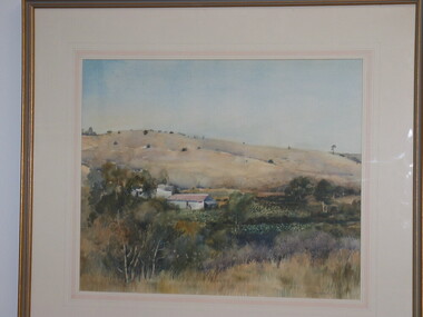
Painting, Summer Keilor, 1989
... Scene, Market Garden landscape Summer Keilor. Watercolour, 39 x ...Local Scene, Market Garden landscapeSummer Keilor. Watercolour, 39 x 48cm -
 Williamstown Botanic Gardens- Hobsons Bay City Council
Photos - Cannons, 1970
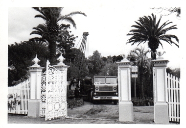
The Armstrong Cannons were originally placed at Fort Gellibrand, located at the southernmost tip of the Williamstown peninsula. The Fort was developed during the 1850s as part of a defensive system for the city and port of Melbourne. The importance of the Fort batteries declined from the 1890s, when they were effectively replaced by new facilities at Queenscliff and Point Nepean, but they were still used for gunnery practice. Local residents, through the Williamstown Town Council, complained to the Acting Minister for Defence that the concussion from the guns damaged windows, walls and foundations of buildings. The Armstrong Cannons were moved from Fort Gellibrand to the Gardens in 1906. A primary source of evidence of the cannons being in the Gardens. The cannons are remembered fondly as play equipment for the local children. Many tales have been told of climbing over them and pretending to be shot out of them A collection of seven black and white photographs documenting the removal of the cannons from the Gardens Photo 1 (a) Black and white landscape image. View is looking through the main gates looking at the front of the truck, which has the name Walter Wright across the front bumper, the crane and canon. The gates and fence are painted a light colour, probably white. Photo 2 (b) Black and white landscape image. Back of loader with cannon on it. Man standing on top of the cannon bending over either tying or untying ropes. Trunk of a palm tree is on the left side of the photo with a top of a palm tree in the background. Photo 3 (c) Black and portrait white image. A cannon being loaded by the crane on to trailer. Palm tree is in the background and fronds from a palm tree can be seen in the right top corner. Photo 4 (d) Black and white landscape image. Side on view of a cannon on the truck parked outside the grounds of the Gardens. The logo of the name of the trucking company is on the door of the truck above the words ‘WALTER H WRIGHT / TRANSPORT PTY LTD / S SCHULZ ST WEST MELB’. A second cannon can be seen in the background. A bus is in the background on the middle right side of the image. Photo 5 (e) Black and white landscape image. Truck with cannon on the back leaving the ground of the Gardens. Tree on the right side of the image and power pole is behind the truck. The logo of the name of the trucking company is on the door of the truck above the words ‘WALTER H WRIGHT / TRANSPORT PTY LTD / S SCHULZ ST WEST MELB’. ‘WALTER WRIGHT’ is on the front bumper Photo 6 (f) Black and white landscape image. Cannon tied down on the back of the truck as it is being driven across the street. Three houses in the background and two cars, one is a Volkswagen Photo 7 (g) Black and white landscape image. Cannon on the back of the truck which is parked over the street from the Gardens. Three houses are in the background. Two trees bare of leaves. The front of a car in in the foreground – it has a sun visor and the steering wheel is a light colour.armstrong cannons, williamstown botanic gardens, hobsons bay city council, 1970, walter h wright / transport pty ltd -
 Williamstown Botanic Gardens- Hobsons Bay City Council
Oral History_Williamstown Botanic Gardens_Helen Page, 24/02/2104
The interview is one of a series recorded in 2013-2014 to document memories and experiences of the Williamstown Botanic GardensA primary source of information on the lobbying that led to master planning for rejuvenation of the Gardens and the formation of the Friends of Williamstown Botanic Gardens. CD and transcript of interview with Helen Page and her memories and experiences in lobbying for the rejuvenation and long-term viability of the Gardens. Helen was a resident of Williamstown when she contacted local Councillor, Angela Altair, in May 1999 to express her concerns about the destruction of trees in Melbourne Road and the condition of the Williamstown Botanic Gardens. The result of her communications with Councillor Altair and the Council was the formation of the Landscape Advisory Group and the Williamstown Botanic Gardens Advisory Group. Still an active member of the Williamstown Botanic Gardens Advisory Group, Helen talks of these experiences, how they led to the formation of the Friends Group and her hopes for the future of the Gardens.helen-page, angela altair, mary klestadt, mike hirst, shelley wood, andrew shannon, williamstown botanic gardens advisory group, master plan, sue murray, kim sawyer, anja lee, golden elm, advisory group, gates, pinetum, victorian heritage register -
 Williamstown Botanic Gardens- Hobsons Bay City Council
Oral History_Williamstown Botanic Gardens_Shelley Wood, 25/09/2014
The interview is one of a series recorded in 2013-2014 to document memories and experiences of the Williamstown Botanic GardensA primary source of information on memories of the Gardens and witness to changes in the Gardens over those years. CD and transcript of interview with Shelley Wood. Shelley was born in Williamstown, as was her mother Margaret McLean. Shelley recalls her mother telling her about spending many hours in the Gardens when she was young with her friend Chic, who was the daughter of the Curator Ernie Anderson. Shelley, who was the first female gardener appointed in the western region, served her apprenticeship at Gardens and is currently the Curator. shelley wood, margaret mclean, tom wood, chic anderson, ernie anderson, 1979, apprentice, fish pond, pinetum, barry heath, golden elm, palms, brian turner, dean splatt, robert anderson, 1988, bicentennial funding, 1987, angela altair, helen page, mary klestadt, mike hirst, john hawker, landscape advisory group, williamstown technical school, gates, buffalo lawn, ian brown, storytime, adam lindsay gordon, statue, archie matthews, aviary, williamstown botanic gardens, hobsons bay city council -
 Surrey Hills Historical Society Collection
Photograph, 'Strathmore' 75 Victoria Crescent, Mont Albert
‘Strathmore’ Victoria Crescent (dem.) Joseph Sutton Crow and his wife Jessie (nee Temby) bought this property which had belonged to the Purbrick family in 1924. Sutton was an amateur ‘planner and landscape designer’ and had much pleasure in planning the use of their garden of 100 feet by 400 feet. While part remained rural with sheep, an orchard and vegetable garden, he laid out sweeping designs for the front garden which Jessie enjoyed converting into a garden worthy of display and which did gain prizes in the Herald Garden competitions of the 1930s. They entertained friends and often had as guests University Conservatorium staff and visiting musical personnel. They also opened the garden for local church fund-raising functions. Children, Jean and Ray, had areas set out for their recreation with pets and activities areas. The donor was their daughter. A black and white photograph of a Californian Style weatherboard house, painted in a dark colour. There is a well established garden in front. There is a bay window at one side of the house.house names, californian bungalow style, weatherboard, victoria crescent, surrey hills, (mr) joseph sutton crow, (mrs) jessie sutton crow, purbrick family, 1924, herald garden competitions, 1930-1939, (miss) jean sutton crow, (mr) ray sutton crow, 'strathmore' -
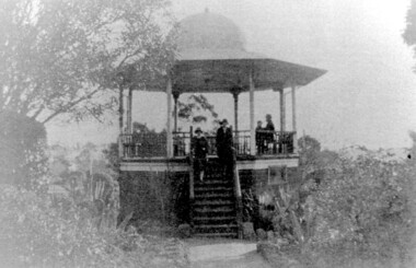 Surrey Hills Historical Society Collection
Photograph, John Gray Memorial Rotunda in Surrey gardens, Union Road, Surrey Hills, c 1925, c 1925
... was a central feature of the Surrey Gardens which was planted ...The rotunda was built in 1912 by Clarence Montgomery for the Surrey Hills Progress Association and the local community and dedicated to John Gray, "a highly respected and revered citizen". Surrey Hills Brass Band regularly gave concerts in the rotunda, provided music for regular 'loyal' celebrations and also for silent films held in the gardens. The rotunda was quite elevated off the ground due to the slope of the gardens and the bioscope was stored in the room underneath. This was later used as the infant welfare centre until the Progress Association built a dedicated facility for these purposes. The rotunda was demolished in 1972. Clarence Montgomery, carpenter, was living in Sunbury Crescent in 1914. By 1916 he had moved to 83 Croydon Road where he lived for the rest of his life. Clarence was born in 1869 in Taradale, son of John Montgomery and Jane Ford. He married Sarah Ann Ingram in Echuca in 1894. Their children were: 1. Annie (Mrs P Paynter) born Echuca in 1895 2. William Henry born Echuca in 1897 3. Christina Mary (Mrs F Meyers) born Echuca in 1898 4. Violet (Mrs G Ewing) born Echuca in 1902 5. Clarence George Ingram born Echuca in 1906 and died aged 7 months. Violet became a tailoress and Christina a dressmaker. William became a carpenter like his father. Sarah Ann Montgomery died at their home in June 1932 aged 62 years. Clarence died in August 1946 aged 77 years. They are buried in Box Hill Cemetery (P-EB-0020). John Gray was "actively associated with all movements for the benefit of neighbours and fellow citizens". [Quote from the official tribute on his death in 1909.] He was very active in the Surrey Hills Progress Association in the early 1900's. The rotunda built in the Surrey Gardens by the Progress Association in 1912 was dedicated to him. John Gray was born in 1861 in Eldorado. He died on 7 December 1909 in Surrey Hills and is buried in Box Hill Cemetery (M0472). He married Emma Beckett in 1888 at 'Guildford Villa' in Essex Road, the Beckett home. They are listed in both the 1903 and 1906 electoral rolls in Arundel Crescent; his occupation is given as bootmaker. The Alan Holt property register identifies this as 24 Arundel Crescent, known as 'Tumberumba'. John and Emma had a large family: (Gunner) John Robert Gray (1888, Surrey Hills - 21 June 1917, France) Benjamin Walter Gray (1890, Surrey Hills - 1949, Heidelberg) Herbert Harry Gray (1892, Surrey Hills - 1959, Queensland) William Beckett Gray (1897, Surrey Hills - 1899, Surrey Hills) Norman Douglas Gray (1901, Surrey Hills - 1947, Sydney) Evelyn Lizzie Gray (1906, Surrey Hills - 1983) Evelyn married Reginald Roberts and donated a number of photos to the collection. The donor Violet Ewing (nee Montgomery) was Clarence's daughter. She married George Isaac Henry Ewing (blacksmith) in 1934. They inherited the family home at 83 Croydon Road. Although constructed 5 years after their opening, this rotunda was a central feature of the Surrey Gardens which was planted to a design adapted from one suggested by the renowned landscape gardener and botanist William Robert Guilfoyle (1840-1912). Rotundas were a key feature of many late nineteenth and early twentieth century public parks. This particular rotunda was notable for the Chinoiserie influence reflected in its roof. Surrey Gardens are now regarded as one of the City of Boroondara's heritage gardens and this image is significant as evidence of the design of the rotunda which is no longer extant. It is also significant as evidence of the extent of the role of the Surrey Hills Progress Association in the provision of public facilities. A black and white photo of an octagonal rotunda situated within Surrey Gardens taken from the perspective of the main entrance. It is a largely wooden structure with a domed chinoiserie-style roof. The rotunda is enclosed by established gardens. There are 4 people in the photo, with 2 women standing on the steps at the rotunda's entrance. A man and a young person are seated within the rotunda. It has 8 support pillars, which are open with balustrades to 7 sides.rotundas, surrey gardens, union road, surrey hills progress association, surrey hills brass band, parks and reserves, 1925, john gray, clarence montgomery, box hill cemetery, cinema, john gray memorial rotunda, bandstands -
 Surrey Hills Historical Society Collection
Book, The National Trust Research Manual: investigating buildings, gardens and cultural landscapes, 1992
... Trust Research Manual: investigating buildings, gardens ...This book explains how to use the many documentary sources that are available, such as rate books, directories and titles; how to investigate and restore exteriors; and, how to recognise the main architectural styles.This book explains how to use the many documentary sources that are available, such as rate books, directories and titles; how to investigate and restore exteriors; and, how to recognise the main architectural styles.historic sites, historic buildings, conservation, (ms) celestina sagazio, national trust of australia -
 Federation University Art Collection
Painting - Artwork, Simpson, Harolyn, 'Garden of Earthly Delights' by Harolym Simpson, 2001
This item is part of the Federation University Art Collection. The Art Collection features over 2000 works and was listed as a 'Ballarat Treasure' in 2007.Brightly coloured landscape. If you can provide information on this artist or artwork please use the email link below. art, artwork, horsham campus art collection, harolym simpson -
 Port Fairy Historical Society Museum and Archives
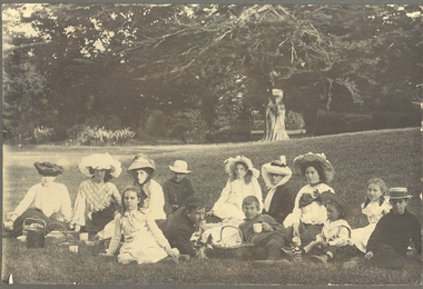
Photograph
Family group picnicing in the Botanical gardens Black and white landscape with 13 people in foreground dressed in clothing of the early 1900’sgardens, family, group, botanical -
University of Melbourne, Burnley Campus Archives
Plan, Laidlaw & Laidlaw, Landscape Design Concept for Children's Garden, May 2010
landscape design, teaching material, laidlaw & laidlaw, children's garden, clifton hill primary school -
University of Melbourne, Burnley Campus Archives
Plan, Andrew Laidlaw, Student Exercise - Landscape Design
Subject taught by Andrew Laidlawlandscape design, student work, teaching material, andrew laidlaw -
University of Melbourne, Burnley Campus Archives
Document - Student Work, Anton Bialylew, An investigative study on Eckersley Garden Architecture (E-GA) to identify the features of their garden design practices, distinguishing style, and philosophy of garden design, 2014
student work, assignment, landscape design -
University of Melbourne, Burnley Campus Archives
Document - Course Notes, Andrew Laidlaw et al, Graduate Certificate in Garden Design Course Notes, 2013
graduate certificate in garden design, garden design, course notes, teaching material, landscape construction