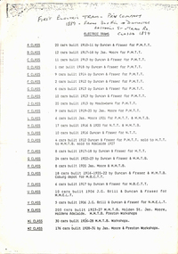
Showing 621 items matching "location map"
-
 Warrnambool and District Historical Society Inc.
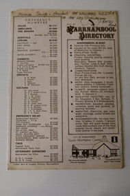
Pamphlet - Warrnambool Directories, Warrnambool City Council (Warrnambool Tourist Information Centre), Warrnambool Directory. Welcome to Warrnambool, Warrnambool and District Directory, 1970s and 80s
Warrnambool Directories.1 and .2 One sheet of paper folded twice to provide six pages. The pages contain a map and printed material. .3 One sheet pf paper folded to provide sixteen pages. The pages contain two maps and printed material. The front page has a stamp indicating the original owner. non-fictionWarrnambool Directorieswarrnambool tourism, shipwreck coast tourism -
 Ringwood and District Historical Society
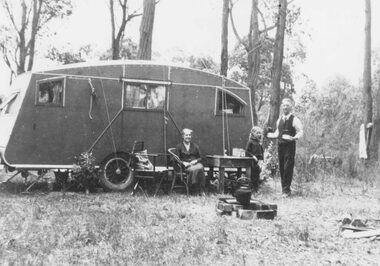
Photograph, Mr. and Mrs. East camping in Illoura Ave., East Ringwood 1941
... , Christmas 1941". Also shows a hand drawn map of location...., Christmas 1941". Also shows a hand drawn map of location. Black ...Black and white photograph (2 copies)Typed below one photograph: "Mr. and Mrs. East camping in Illoura Ave., East Ringwood opposite "Alexandra Ave. Christmas 1941." Written on back of other photograph: "Caravan in paddock opposite home of Mr. & Mrs. Harry Thomas, Alexander Road, Ringwood, Christmas 1941". Also shows a hand drawn map of location. -
 Lakes Entrance Historical Society
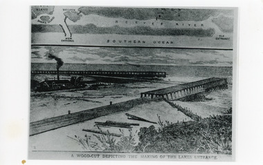
Photograph - Entrance Works, 1880c
... of the building of the entrance and map above of location.... of the building of the entrance and map above of location. Public Works ...Photographic reproduction of woodcut drawing of the building of the entrance and map above of location.Black and white photograph of a woodcut showing dredge working between timber constructed piers on entrance from the lakes to the ocean Bass Strait. Piers unfinished, timber lying around, sand in the entrance. Map above showing position of the lakes, old and new entrances, southern ocean and sand dune vegetation. Lakes Entrance VictoriaA woodcut depicting the making of the Lakes Entrance.public works, dredging, waterways -
 Melbourne Tram Museum
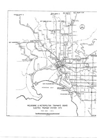
Drawing, Melbourne & Metropolitan Tramways Board (MMTB), "Melbourne & Metropolitan Tramways Board Electric Tramway System 1979", 1979
Photocopy of the track plan for the Melbourne Tramway System in 1979 over two separate sheets - titled "Melbourne & Metropolitan Tramways original pr Board Electric Tramway System 1979". Shows the route numbers and terminus names, depot locations, rail lines, cross overs and junctions. Has the name J.Chau in bottom left hand corner. See item 7740 for an original print.trams, tramways, melbourne, map, trackwork, depots, route numbers, railways, junction -
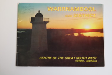 Warrnambool and District Historical Society Inc.
Booklet - Tourist Booklet, Warrnambool Chamber of Commerce and Industry, Warrnambool and District - Centre of the Great South West, Victoria, Australia, c. 1970
Warrnambool Tourist BookletThis is a booklet of 22 pages. The cover has two colour photographs and the pages contain a sketch map, printed text and colour photographs. The pages have ben stapled but the staples have been removed.non-fictionWarrnambool Tourist Bookletwarrnambool tourism, south west victoria tourist locations, warrnambool chamber of commerce -
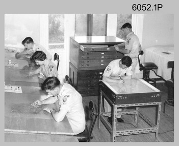
 Bendigo Military Museum
Photograph - Royal Australian Survey Corps - Map Production Processes, c1990
This is a collection of 20 photographs of Royal Australian Survey Corps phases of map production at the School of Military Survey, Bonegilla, the Army Survey Regiment, Bendigo, and the Army Map Depot, Bandiana circa 1990. Colour photos are on 35mm slide film and were scanned at 96 dpi. They are part of the Army Survey Regiment’s Collection. Photo .1P was probably taken on a survey station overlooking Lake Hume near Albury-Wodonga. The field party occupying the survey station was likely from a Map Control Survey course conducted by the School of Military Survey, Bonegilla. This survey station was part of a geodetic network used in field survey training and RASvy’s Lake Hume Test Range. Photos .3P to .16P were taken at the Army Survey Regiment, Bendigo and photos .17P & .18P were taken at the Army Map Depot, Bandiana. Photo .19P depicts a map of RASvy’s ARA units before the disbandment of 5th Field Survey Squadron, Perth and 2nd Field Survey Squadron, Sydney in 1990. This is a collection of 20 photographs of map production processes taken at the School of Military Survey, Bonegilla, the Army Survey Regiment, Bendigo, and the Army Map Depot, Bandiana circa 1990. Colour photos are on 35mm slide film and were scanned at 96 dpi. They are part of the Army Survey Regiment’s Collection. Photo .2P is printed on photographic and scanned at 300 dpi. .1) – Photo, colour, c1980s. Geodetic Surveying: AN/PRR-14 Geoceiver antenna on hill surrounding Lake Hume. Series 3 Land Rover, field party tent and survey station beacon in background. .2) – Photo, black & white, c1980s. Geodetic Surveying: AN/PRR-14 Geoceiver antennas set up at the School of Military Survey, Bonegilla, Victoria. .3) – Photo, colour, c1990. Aerotriangulation: Wild PUG4 point transfer device, SSGT Bruce Hammond. .4) – Photo, colour, c1990. Aerotriangulation: Zeiss (Jena) Stecometer, SSGT Bruce Hammond. .5) – Photo, colour, c1990. Aerotriangulation: computer tape maintenance, SSGT Noel McNamara. .6) – Photo, colour, c1990. AUTOMAP 2: computer tape maintenance, SPR Nadine (Paul) Read. .7) - Photo, colour, c1990s. AUTOMAP 2: Optronics 4040 scanning/film output in Lithographic Squadron, SGT Sherri (Dally) Burke. .8) - Photo, colour, c1990s. AUTOMAP 2: Benson verification plotter output, SPR Nadine (Paul) Read. .9) – Photo, colour, c1990. Aerotriangulation: data management, SGT Neil ‘Ned’ Kelly. .10) & .11) - Photo, colour, c1990s. AUTOMAP 2: Wild B8 Aviograph stereoplotter Feature Extraction, unidentified technician. .12) - Photo, colour, c1990s. AUTOMAP 2: Graphic Edit Workstation, SPR Nadine (Paul) Read. .13) - Photo, colour, c1990s. AUTOMAP 2: Graphic Edit Workstation, SPR Dawn Hoadley. .14) & .15) - Photo, colour, c1990s. AUTOMAP 2: Graphic Edit Workstation, unidentified technician. .16) – Photo, colour, c1990s. Heidelberg Speedmaster 102 computer-controlled five colour lithographic offset printing press. .17) & .18) – Photo, colour, c1990s. Army Map Depot, unidentified storeman, Bandiana. .19) – Photo, colour, c1990. RASvy ARA Unit Locations before disbandment of field units in Perth and Sydney. .20) – Photo, colour, c1990. Set of overlapping aerial photography..1P, .3P to .20P - Some equipment is identified on the frame of the 35mm slides.royal australian survey corps, rasvy, army survey regiment, army svy regt, fortuna, asr, school of military survey, army map depot -
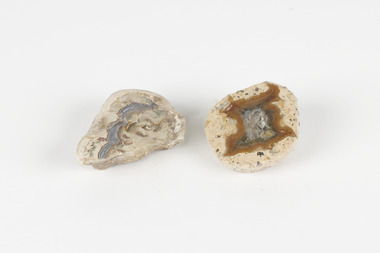 The Beechworth Burke Museum
Geological specimen - Thunderegg agates, Unknown
Thunderegg Agates are formed within rhyolite volcanic ash layers. They are rough spherical shapes, varying in size from less than an inch to over a metre long. Thundereggs usually contain centres of chalcedony which may have been fractured followed by deposition of agate, jasper or opal, either uniquely or in combination. A unique characteristic that these specimens have is the fact that they often look like ordinary rocks on the outside, but slicing them in half and polishing them may reveal intricate patterns and colours. These particular specimens are examples of thunderegg agates. Agate is a variety of chalcedony, a cryptocrystalline form of quartz. The agate component contributes to the intriguing internal patterns of the specimens. The specific locality of these specimens is unknown but they can be found in flows of rhyolite lava. They are formed in gas pockets in the lava, which act as moulds. These specimens can be found globally, with specific locations in Germany being particularly abundant. This specimen is part of a larger collection of geological and mineral specimens collected from around Australia (and some parts of the world) and donated to the Burke Museum between 1868-1880. A large percentage of these specimens were collected in Victoria as part of the Geological Survey of Victoria that begun in 1852 (in response to the Gold Rush) to study and map the geology of Victoria. Collecting geological specimens was an important part of mapping and understanding the scientific makeup of the earth. Many of these specimens were sent to research and collecting organisations across Australia, including the Burke Museum, to educate and encourage further study.Two small solid specimens with pale, sandy-coloured exteriors and fractured internal patterns. burke museum, beechworth, geological, geological specimen, thundereggs, thundereggs agate, agate, rhyolite, rhyolite lava, volcanic ash, chalcedony, cryptocrystalline -
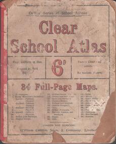 Bendigo Historical Society Inc.
Book - SCHOOL ATLAS, 1880s
Atlas. 34 page 'CLEAR SCHOOL ATLAS' in colour. Price sixpence. On the map of Australia, page 32, the location of Sandhurst is shown. Handwritten in ink at top of front cover, 'Fifth Class, Bamawm'William Collins, Sons & Company, London and Glasgoweducation, bendigo, atlas, bamawm, sandhurst -
 Bendigo Military Museum
Photograph - Scribing at the Army Survey Regiment, c1950s to 1979
These 10 photographs were taken over two decades from the late 1950s to 1979 at the Army Survey Regiment, Fortuna, Bendigo. The two photos taken in 1961 are annotated with named personnel and the date. The other photos are not annotated with dates, locations and names of personnel, although the technicians in the last three photos taken in 1979 are positively identified. The photos were most likely taken in the Ballroom, Ante Room and Attic, Cartographic Squadron’s main production rooms on the top floor of Fortuna Villa. Scribing was the cartographic process of drafting topographic features such as drainage, relief, vegetation, roads and culture on specially coated map reproduction material. The cartographic technician scribed out the map feature such as a creek to a specified line width on the map sheet, using a tool affixed with a metal or sapphire tipped cutter.This is a set of 10 photographs of technicians scribing topographic features at the Army Survey Regiment, Bendigo. The photographs were printed on photographic paper and are part of the Army Survey Regiment’s Collection. The photographs were scanned at 300 dpi. .1) - Photo, black & white, c1950s. unidentified personnel in Cartographic Squadron .2) - Photo, black & white, c1960s. unidentified personnel in Cartographic Squadron .3) - Photo, black & white, c1960s. unidentified personnel in Cartographic Squadron Attic .4) - Photo, black & white, c1960s. Cartographic Squadron Attic .5) - Photo, black & white, Oct 1961. L to R: PTE P. Carseldine, PTE H.S. Pasley, PTE C.A. Brown, WO2 M.A. McLaren, CPL Jennifer H. Murray. Cartographic Squadron .6) - Photo, black & white, Oct 1961. CPL Jennifer H. Murray. Cartographic Squadron .7) - Photo, black & white, 1979. SPR Mick Ellis in Cartographic Squadron .8) - Photo, black & white, 1979. SPR Mark Casey in Cartographic Squadron .9) - Photo, black & white, 1979. SPR Sharon (Jones) Treble in Cartographic Squadron .10) - Photo, black & white, 1961. PTE BJ Madex. Cartographic Squadron.1 to .4 - annotated “Scribing” .5 – annotated “Scribing PTE P. Carseldine, PTE H.S. Pasley, PTE C.A. Brown, WO2 M.A. McLaren, CPL Jennifer H. Murray. Oct 1961” .6 - annotated “Scribing CPL Jennifer H. Murray. Oct 1961” .7 to .9 - annotated “Scribing” .10 – annotated “PTE Madex Oct 61”royal australian survey corps, rasvy, army survey regiment, army svy regt, fortuna, asr, carto -
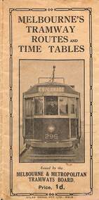 Melbourne Tram Museum
Map, Melbourne & Metropolitan Tramways Board (MMTB), Melbourne's tramway routes and timetables - MMTB, 1925
Map of the MMTB Tramway routes 1925 with a list of first and last cars, along with photographs of Wattle Park, Luna Park, and Studley Park. Provides information for the Prahran and Malvern lines, Hawthorn, Footscray, Essendon, Coburg, Kew, St Kilda, cable tram routes, and buses. Also provides information for passengers. The cover photo is of the front of W 296, with the destination of Esplanade. The map is dated by the opening of the line to West Brunswick as far as Albion St, the City Road to St Kilda line via Sturt St lines, and the electric line in Flemington Road which were all opened during mid to late 1925. See Reference. Shows a number of buildings and locations by a numbered reference list, including the Federal Parliament house. The map has advertisements around the outside of the map for Kiwi Shoe or boot polish.Yields information about the Melbourne tramway system in 1925 and demonstrates the methodology the MMTB used to provide information to travellers. Shows both cable and electric tram lines and the development of the Melbourne system.Map book - 15 fold paper titled "Melbourne's tramway routes and timetables"trams, tramways, mmtb, tramway maps, wattle park, studley park, timetables, cable trams, w class tram, tram 296, kiwi shoe polish -
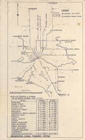 Melbourne Tram Museum
Map, Melbourne cable tram system, 1971?
Map showing the Melbourne cable tram system, with a list of opening and closing dates for the various lines, opened by the Melbourne Tramways Trust. Shows engine houses and car houses (or depots), location names, railways, and a scale. Includes notes on other dates tracks were changed and the Northcote to Clifton Hill line. No marks as to who prepared the map.Yields information about the Melbourne Cable Tram system.Foolscap sheet - Map - Melbourne cable tram system showing tracks, car houses and engine houses.Has a date stamp 22 Apr 1971 in bottom right hand corner.tramways, cable trams, trams, map, melbourne tramways trust, mtt, engine houses, depots, car houses -
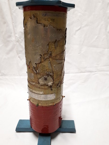 Vision Australia
Map - Object, R.F. Tunley, Braille cylinder map, 1940-1950s
This map was produced by Richard Francis Tunley and given to the Victorian Braille Library for use by it's patrons. Mr Tunley was a prolific Braille map maker as well as producing other items for blind and vision impaired children, advocated for compulsory education for blind and deaf children and established the Queensland Braille Map and Model Club. Leading by example, his maps were treasured by those who used them and were an outstanding piece of craftsmanship. In this example, the metal cylinder sits on a wooden base and can be turned via a handle in the wooden top or rotating the sides. A brailled red metal plate occupies the bottom third, and large continents have a metal plate, cut to shape, upon which braille country/continent names are placed. Major rivers are traced through raised lines in the metal continental plates, twisted wire traces shipping routes with associated brailled metal plates, raised metal pins in some major locations and more explanatory plates sit in various oceans.1 metal cylindrical map with tactile markersCommercial & Strategic Map of the British Empire Presented to the Victorian Braille Librarybraille library of victoria, r.f. tunley -
 Lakes Entrance Historical Society
Book, Jones Rebecca, An Ideal Excursion: A Recreation History of the Gippsland Lakes and its Guesthouses, 1880-1930, 1994
... as a thesis for a student during a master of arts degree sketch maps... degree sketch maps are used for location purposes photographs ...A history of guest houses and recreational pursuits of person holidaying in the gippsland lakes hinterland written as a thesis for a student during a master of arts degree sketch maps are used for location purposes photographs (photocopy) illustrations.guesthouses, settlers, tourism -
University of Melbourne, Burnley Campus Archives
Plan, VCAH Burnley College Swan Street Richmond - Classroom Locations Map, c.1991
... Street Richmond - Classroom Locations Map Plan ...2 copies of plan dated c1991. Buildings named, classrooms numbered.vcah, burnley, classrooms -
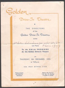 Bendigo Historical Society Inc.
Programme - Bendigo Golden Drive-in Theatre Gala Premier
... card with yellow and blue printing. Reverse has a map showing... and blue printing. Reverse has a map showing the location ...The Gala opening was held on 8/12/1955 and the Drive-in closed 3/2/1985. It was situated on the Western side of Crook Street and had one screen and the capacity for 700 cars. It was run by the Houlihan family.Invitation to the Gala Premier Opening of Bendigo's Golden Drive-in Theatre on Thursday 8th December 1955. Cream coloured card with yellow and blue printing. Reverse has a map showing the location of the Theatre.Invite has been offered to Mrs Ellen Colvin, Tom & Joe, also Mr & Mrs F. Colvin and familyinvitation, drive in theatre, golden drive-in theatre' -
 Bendigo Historical Society Inc.
Document - RALH BIRRELL COLLECTION: OLD MINING SITES WHITE HILLS, Dr. Ralph Birrell (now deceased)
4-page typed document, prepared by Dr. Ralph Birrell, on the significance of the former mining sites on the White Hills. Document describes the 'area adjacent to the old Railway Workshops as shown on attached map'. A further addition (slip of paper, typed) to the paper describes the location of the Whiter Hills of White Hills: 1st White Hill is east of Lake Weeroona The 2nd and 3rd White Hills are around Strickland Road, former East Bendigo Primary School, Baden/Powell Streets The 4th and 5th White Hills are east of Napier and Grace Street The 6th White Hill is east of Plumridge Street The 7th White Hill is east of Bosquet Street. -
 Whitehorse Historical Society Inc.
Book - Manufacturing History, 19th century, Victoria's Earliest Potteries (Our Convict Era Potters), 2019
... styles of the time and maps locating the pottery location. ... styles of the time and maps locating the pottery location ...This book covers the formative years of Victoria's pottery industry during the second half of the 19th Century. It includes a section on Nunawading's Dahle's Filter and Pottery Works operating between 1870 and1876.This book covers the formative years of Victoria's pottery industry during the second half of the 19th Century. It includes a section on Nunawading's Dahlke's Filter and Pottery Works operating between 1870 and1876. The White Bros acquired the pottery in 1888 and called it Springfield Pottery (1888-1911).non-fictionThis book covers the formative years of Victoria's pottery industry during the second half of the 19th Century. It includes a section on Nunawading's Dahle's Filter and Pottery Works operating between 1870 and1876.potteries, dahlke's filter and pottery works, geal's pottery, daniel robertson, australian tesselated tile company, wunderlich, 1800's -
 Bendigo Military Museum
Photograph - 4th Field Survey Squadron – Operation NERVOSE 85 Reconnaissance, Northern Territory, 1985
This is a set of 13 photographs taken in 1985* during reconnaissance of locations in regions of the Northern Territory. Later that year, Operation NERVOSE 85 was mounted by 4 Fd Svy Sqn in the EAST ARNHEM, VICTORIA RIVER DOWNS AND DALY WATERS areas of the Northern Territory from 26 May to 18 Sep 85. The aim of Operation NERVOSE 85 was to finalise the horizontal and vertical control for mapping at a scale of 1:50,000, to field check 40x 1:50,000 preliminary maps and to obtain mapping photography in support of the RAAF TINDAL redevelopment project. *Note –These photos were most likely taken in 1985, contrary to the ‘1987’ date annotated on the negative sleeves. The Op NERVOSE 85 Project Report available on RASVY’s web site lists a nominal roll of personnel. Photos of 4 Fd Svy Sqn taken in 1985 and 1987 provide names of posted personnel. Several personnel identified in these photos were posted to 4 Fd Svy Sqn in 1985, not in 1987.This is a set of 13 photographs taken during 4th Field Survey Squadron’s reconnaissance of Operation NERVOSE 85 locations in the Northern Territory in 1985. The colour photographs are on 35mm negative film and are part of the Army Survey Regiment’s Collection. The photographs were scanned at 96 dpi. .1) to .4) - Photo, colour, 1985. Unknown location in the Northern Territory. .5) - Photo, colour, 1985. Unidentified personnel in the back of a police vehicle. .6P to .12) - Photo, colour, 1985. Unknown location in the Northern Territory. .13) - Photo, colour, 1985. L to R: Possibly MAJ A. Vickers RE - UK Exchange Officer from Army Svy Regt, unidentified officer. .1P to .13P – There are no personnel identified. ‘1987 OP NERVOSE – RECON PHOTOG.’ annotated on negative sleeve.royal australian survey corps, rasvy, 4 fd svy sqn, op nervose 85 -
 Melbourne Tram Museum
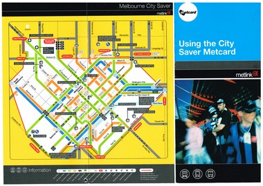
Pamphlet, Metlink, "Using the City Saver Metcard", 2004
Pamphlet - DL size, three fold full colour printed on gloss paper titled "Using the City Saver Metcard", giving details of the card, availability on both train, bus and tram, a map showing the area and major locations within the ticket area. Also has details of how they could be purchased. Printed by Metlink. Has a reference to the fare structure of 2004.trams, tramways, metcard, metlink, city saver, tickets -
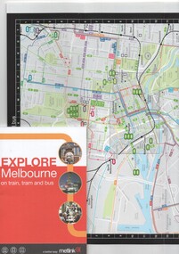 Melbourne Tram Museum
Book, Metlink, "Explore Melbourne on train, tram and bus", Jan. 2009
Book - 42 pages + cover + foldout map, perfect bound - titled "Explore Melbourne on train, tram and bus" giving details of many locations, venues that could be travelled to by public transport, how to buy Metcards, map of the inner area and transport routes. Places of Interesttrams, tramways, melbourne, local history, metlink, public transport, map -
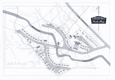 Marysville & District Historical Society
Map (Item) - Marysville Caravan Park map, Marysville CARAVAN PARK-Park Map, Unknown
A map of the Marysville Caravan Park showing the location of the various sites and facilities available to guests.A map of the Marysville Caravan Park showing the location of the various sites and facilities available to guests.marysville, victoria, australia, marysville caravan park, map -
Port Melbourne Historical & Preservation Society
Plan - Handcoloured location of Libbis family members' homes on copy of a section of 1894 MMBW map, 1894
Obtained from MMBW by Peter LIBBIS when researching Libbis family historyPhotocopy of a section of 1894 MMBW plan 118 which have been handcoloured to indicate locations such as homes of various Libbis family membershandcoloured to indicate locations such as homes of various Libbis family membersbuilt environment, families, peter libbis -
Port Melbourne Historical & Preservation Society
Plan - Handcoloured location of Libbis family members' homes on copy of a section of 1894 MMBW map, 1894
Obtained from MMBW by Peter LIBBIS when researching Libbis family historyPhotocopy of a section of 1894 MMBW plan 118 which has been handcoloured to indicate locations such as homes of various Libbis family membershandcoloured to indicate locations such as homes of various Libbis family membersbuilt environment, families, peter libbis -
 Mont De Lancey
Book, D.W. Chandler Ltd, D.W. Chandler General Hardware Ltd. Catalogue, 1937
A comprehensive 1937 catalogue of general hardware for household and farm use for buyers to order in Melbourne and rural cities in Australia. The company was established in 1876. This is the 49th issue.A comprehensive thick catalogue book: D.W. Chandler General Hardware Ltd. Catalogue established 1876 which has a very decorative busy front cover with green, burgundy and cream colours for the title, full details of the contents, address, Registered Trademark, phone numbers and more. It is bound on the spine with red tape, 27.5 Inside on the left front end paper are details about Chandler's mail orders, a map of the Melbourne city location and addresses for Melbourne, Fitzroy and country cities. Opposite is a NOTICE page, explaining prices were current at the time of issue, (October 1937) with several altered prices since printing. Pp. 180 with four thin blue paper Order Forms at the back; two which have been filled in and two with a child's scribble on them. There is a comprehensive four page Index at the back. Hundreds of black and white drawings of hardware items and general life of the times are included throughout. Inserted in the catalogue are four dried plants or flowers, a small leaflet which shows illustrations and information about "Rega" spraying nozzles with diagrams and handwritten prices. A leaflet of a Parts Price List for Stewart No.1 Clipping machine and clipping heads. A copy of a D. W. Chandler Ltd Fitzroy order dated 12 March 1937 for "Ringlock" Fencing. On page 146 is a light blue thin paper Note for P146 about models of Churchill's and Jeffery's guns. Attached to this paper with cellotape is a typed copy dated 10/11/37 for an order for Square Iron Tanks to be delivered by rail. The back cover has advertising for "Perfect" Welded Fencing from Chandler's hardware stores. There is a manufactured hole by the publisher in the top left hand corner to hang it for future reference.non-fictionA comprehensive 1937 catalogue of general hardware for household and farm use for buyers to order in Melbourne and rural cities in Australia. The company was established in 1876. This is the 49th issue. social history, australian history, history, hardware, catalogues, objects, tools -
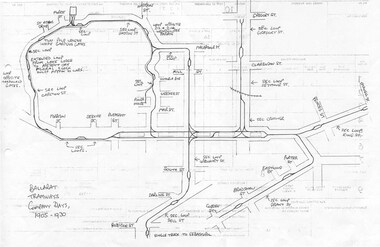 Ballarat Tramway Museum
Document - Photocopy, Dave Macartney, Drawing of ESCo Ballarat Tramways, c1990
Photocopy of a drawing prepared by Dave Macartney in the mid 1980's of the track layout of the Electric Supply Co. of Victoria's Ballarat Tramway system, excluding the single track to Sebastopol. Plan shows the location of the loops, loop type, street names, position of replacement loops installed by the SEC during the reconstruction, depot layout, powerhouse siding and railway in Lydiard St. North. Prepared from inspecting the Plans of Ballarat services drawings in the Ballarat Water Board's Offices. Drawn on the back of old import forms of a light weight paper and has shown through the printing underneath. Titled "Ballarat Tramways Company Days 1905 - 1930" Number of small differences to the map drawn for Keith Kings, "The Ballarat Tramways" book, page 22.trams, tramways, ballarat, esco, track layout, map -
 Melbourne Tram Museum
Document - Folder with papers, Australian Electric Traction Association (AETA), "Electric Trams", "Cable tramways", 1990
Folder (manila colour Avery Spiral Spring Action File" containing a 16 page A4 photocopied report or list titled "Electric Trams", looking at the Melbourne tram fleet history c1990, the history of the MMTB, cable trams, horse trams, the trusts and Trams preserved within Victoria at the time. The rear sheet is map of the Melbourne tramway system about 1901. Shows the location of the winding houses. 2nd loose copy added 9/12/2019 from the donation of Peter Cohen 9/11/2019.trams, tramways, history, mmtb, cable trams, tramcars, horse trams, preserved trams, map -
 Melbourne Tram Museum
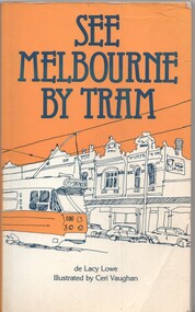
Book, Lacy Lowe, Ceri Vaughan, "See Melbourne by Tram", 1982
Book - 160 pages + card cover with maps on inside covers, titled "See Melbourne by Tram" written by de Lacy Lowe, illustrated by Ceri Vaughan, published 1982. Gives a description of 22 Melbourne tram routes with a stop description (not all stops covered) and sketches associated with the location. Has an index in the rear pages.trams, tramways, melbourne, tram routes, tram stops, tourist guides, illustrations -
 Melbourne Tram Museum
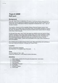
Document - Instruction, Yarra Trams, "Tram It 2006 - Staff Pack", Oct. 2006
Instruction or Staff Pack - 6 A4 pages, stapled in the top left hand corner, titled "Tram It 2006 - Staff Pack". Gives background to the even, location, activities, Entertainment, lunch, uniforms, parking, notes for Volunteers, important phone numbers, Roster and Map.trams, tramways, yarra trams, 100 years of electric trams, docklands, displays, tramcars, volunteers