Showing 14772 items
matching north road
-
 Ringwood and District Historical Society
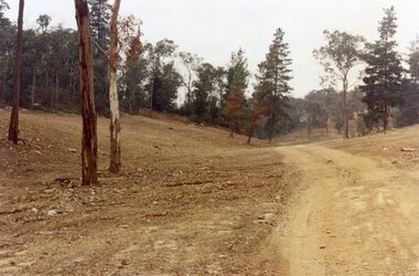
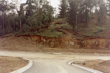
Photograph, Kubis Estate, North Ringwood in April 1978. Looking upstream from below the retaining wall of Loughnan's Lake that was where the truck tracks disappear. The wall was extended to the left across what was then a small gorge
... of the "Kubis" Estate, Ringwood North, including road works to Debbie... Road Ringwood North melbourne E548 N19 Part of a 51-photo ...E548 N19 Part of a 51-photo record of the development of the "Kubis" Estate, Ringwood North, including road works to Debbie Place, Kubis Drive, Werac Drive, Manuelo Drive, Iluka Place and Glenvale Road. From the Jack Lundy Clarke collection. -
 Ringwood and District Historical Society
Photograph, Kubis Estate, North Ringwood in April 1978. Looking west over site of Loughnan's Lake. The rope tree was on the slope to the right beyond the ridge with the lone pine
... of the "Kubis" Estate, Ringwood North, including road works to Debbie... Road Ringwood North melbourne E548 N15 Part of a 51-photo ...E548 N15 Part of a 51-photo record of the development of the "Kubis" Estate, Ringwood North, including road works to Debbie Place, Kubis Drive, Werac Drive, Manuelo Drive, Iluka Place and Glenvale Road. From the Jack Lundy Clarke collection. -
 Ringwood and District Historical Society
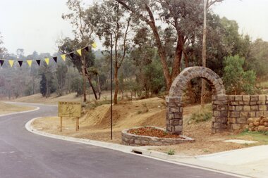
Photograph, Werac Drive, North Ringwood, entrance to Bel-Air Country Club in April 1978
... of the "Kubis" Estate, Ringwood North, including road works to Debbie... Road Ringwood North melbourne E548 N11 Part of a 51-photo ...E548 N11 Part of a 51-photo record of the development of the "Kubis" Estate, Ringwood North, including road works to Debbie Place, Kubis Drive, Werac Drive, Manuelo Drive, Iluka Place and Glenvale Road. From the Jack Lundy Clarke collection. -
 Ringwood and District Historical Society
Photograph, Loughnan Lake site over Kubis Drive, North Ringwood, on 14 April 1978. The retaining wall was where the car tracks disappear over the ridge where the spillway was
... of the "Kubis" Estate, Ringwood North, including road works to Debbie... Road Ringwood North melbourne E548 N13 Part of a 51-photo ...E548 N13 Part of a 51-photo record of the development of the "Kubis" Estate, Ringwood North, including road works to Debbie Place, Kubis Drive, Werac Drive, Manuelo Drive, Iluka Place and Glenvale Road. From the Jack Lundy Clarke collection. -
 Ringwood and District Historical Society
Photograph, "Kubis Estate", North Ringwood, in April 1978. Looking north-east over Loughnan's Lake greatest width. The rope tree was on the slope in the centre. The spillway was on the near left of the image
... of the "Kubis" Estate, Ringwood North, including road works to Debbie... Road Ringwood North melbourne E548 N17 Part of a 51-photo ...E548 N17 Part of a 51-photo record of the development of the "Kubis" Estate, Ringwood North, including road works to Debbie Place, Kubis Drive, Werac Drive, Manuelo Drive, Iluka Place and Glenvale Road. From the Jack Lundy Clarke collection. -
 Ringwood and District Historical Society
Photograph, Junction of Kubis Drive and Iluka Court, North Ringwood, in February 1979. Looking south with Hubbard Reserve beyond
... of the "Kubis" Estate, Ringwood North, including road works to Debbie... Road Ringwood North melbourne E552 N25 Part of a 51-photo ...E552 N25 Part of a 51-photo record of the development of the "Kubis" Estate, Ringwood North, including road works to Debbie Place, Kubis Drive, Werac Drive, Manuelo Drive, Iluka Place and Glenvale Road. From the Jack Lundy Clarke collection. -
 Ringwood and District Historical Society
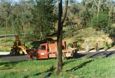
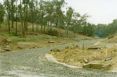
Photograph, The Telecom gang laying pipes in Kubis Drive, North Ringwood, near Jenkins Close, on 10th June 1978
... of the "Kubis" Estate, Ringwood North, including road works to Debbie... Road Ringwood North melbourne E550 N5 Part of a 51-photo record ...E550 N5 Part of a 51-photo record of the development of the "Kubis" Estate, Ringwood North, including road works to Debbie Place, Kubis Drive, Werac Drive, Manuelo Drive, Iluka Place and Glenvale Road. From the Jack Lundy Clarke collection. -
 Ringwood and District Historical Society
Photograph, Looking east up the gully over the intersection of Werac and Kubis Drives, North Ringwood, in February 1978
... of the "Kubis" Estate, Ringwood North, including road works to Debbie... Road Ringwood North melbourne E546 N3 Part of a 51-photo record ...E546 N3 Part of a 51-photo record of the development of the "Kubis" Estate, Ringwood North, including road works to Debbie Place, Kubis Drive, Werac Drive, Manuelo Drive, Iluka Place and Glenvale Road. From the Jack Lundy Clarke collection. -
 Ringwood and District Historical Society
Photograph, Corner of Pamela Court and Kubis Drive, North Ringwood, looking west on 3rd November 1978
... of the "Kubis" Estate, Ringwood North, including road works to Debbie... Road Ringwood North melbourne E551 N15 Part of a 51-photo ...E551 N15 Part of a 51-photo record of the development of the "Kubis" Estate, Ringwood North, including road works to Debbie Place, Kubis Drive, Werac Drive, Manuelo Drive, Iluka Place and Glenvale Road. From the Jack Lundy Clarke collection. -
 Ringwood and District Historical Society
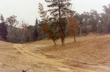
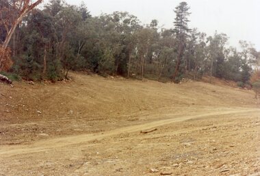
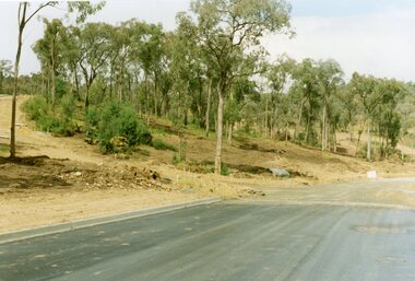
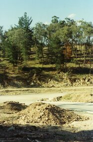
Photograph, Looking west across Werac and Kubis Drives, North Ringwood, in April 1978. Loughnan's Lake site. The retaining wall was where the truck tracks disappear over thhe ridge. The spillway was at that spot
... of the "Kubis" Estate, Ringwood North, including road works to Debbie... Road Ringwood North melbourne E548 N3 Part of a 51-photo record ...E548 N3 Part of a 51-photo record of the development of the "Kubis" Estate, Ringwood North, including road works to Debbie Place, Kubis Drive, Werac Drive, Manuelo Drive, Iluka Place and Glenvale Road. From the Jack Lundy Clarke collection. -
 Ringwood and District Historical Society
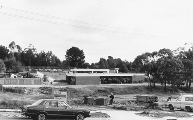
Photograph, Holy Spirit School, North Ringwood, viewed from Jull Road - 1981
... from Jull Road. North Ringwood at Holy Spirit School".... Road Ringwood North melbourne Written on back of photograph ...Written on back of photograph, "E620. 1981. Looking west from Jull Road. North Ringwood at Holy Spirit School". -
 Camberwell Historical Society
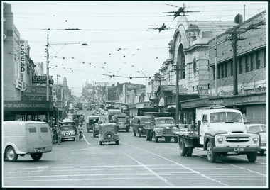
Photograph, Camberwell, Victoria, view of Burke Road and stores, c. 1950
... Print of photograph looking north up Burke Road... and stores c. 1950 Print of photograph looking north up Burke Road ...Print of photograph looking north up Burke Road, with Rivoli Cinema on the right. Inscription 'Camberwell, Victoria, view of Burke Road and stores c. 1950' Camberwell, Victoria, view of Burke Road and stores c. 1950camberwell -
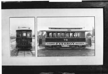 Melbourne Tram Museum
Photograph - Black and White photograph, c1910
... No. 72, lettered for "St Georges Fitzroy Road North" Copy print... Georges Fitzroy Road North" Copy print from a framed photograph ...Black and white photograph of four wheel cable trailer No. 72, lettered for "St Georges Fitzroy Road North" Copy print from a framed photograph.trams, tramways, cable trams, trailers, tram 72 -
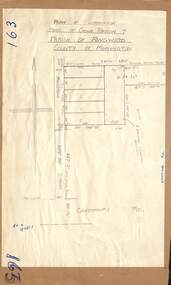 Ringwood and District Historical Society
Map - Plan of Subdivision, Part of Crown Portion 7, Parish of Ringwood, County of Mornington - circa 1950
... Ringwood, north of Canterbury Road.... of Maidstone Street Ringwood, north of Canterbury Road. Part of Crown ...Hand-drawn map attached to light cardboard backing showing 5 residential allotments on eastern side of Maidstone Street Ringwood, north of Canterbury Road.RFK 8/11/51 -
 Ringwood and District Historical Society
Photograph, Kubis Drive and Debbie Place, North Ringwood, on 3rd November 1978, looking east
... of the "Kubis" Estate, Ringwood North, including road works to Debbie... Road Ringwood North melbourne E551 N13 Part of a 51-photo ...E551 N13 Part of a 51-photo record of the development of the "Kubis" Estate, Ringwood North, including road works to Debbie Place, Kubis Drive, Werac Drive, Manuelo Drive, Iluka Place and Glenvale Road. From the Jack Lundy Clarke collection.51 -
 Ringwood and District Historical Society
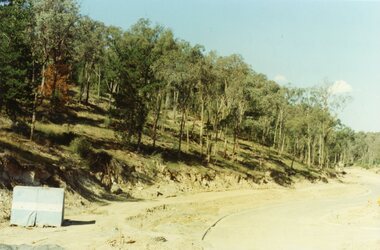
Photograph, Looking from Werac Drive, North Ringwood, on 14th April 1978, across the site of the headwaters of Loughnan's Lake. Main body of water lay to the left (west)
... of the "Kubis" Estate, Ringwood North, including road works to Debbie... Road Ringwood North melbourne E548 N7 Part of a 51-photo record ...E548 N7 Part of a 51-photo record of the development of the "Kubis" Estate, Ringwood North, including road works to Debbie Place, Kubis Drive, Werac Drive, Manuelo Drive, Iluka Place and Glenvale Road. From the Jack Lundy Clarke collection.51 -
 Ringwood and District Historical Society
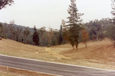
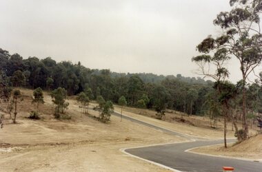
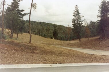
Photograph, Looking west from Kubis Drive, North Ringwood, in April 1978, over the full length of the site of Loughnan's Lake
... of the "Kubis" Estate, Ringwood North, including road works to Debbie... Road Ringwood North melbourne E548 N5 Part of a 51-photo record ...E548 N5 Part of a 51-photo record of the development of the "Kubis" Estate, Ringwood North, including road works to Debbie Place, Kubis Drive, Werac Drive, Manuelo Drive, Iluka Place and Glenvale Road. From the Jack Lundy Clarke collection.51 -
 Ringwood and District Historical Society
Photograph, Looking up Debbie Place, North Ringwood, on 3rd November 1978, that has box sheet of metal
... of the "Kubis" Estate, Ringwood North, including road works to Debbie... Road Ringwood North melbourne E551 N14 Part of a 51-photo ...E551 N14 Part of a 51-photo record of the development of the "Kubis" Estate, Ringwood North, including road works to Debbie Place, Kubis Drive, Werac Drive, Manuelo Drive, Iluka Place and Glenvale Road. From the Jack Lundy Clarke collection.51 -
 Ringwood and District Historical Society
Photograph, Looking north from between Werac and Kubis Drives, North Ringwood, in February 1978
... of the "Kubis" Estate, Ringwood North, including road works to Debbie... Road Ringwood North melbourne E546 N3 Part of a 51-photo record ...E546 N3 Part of a 51-photo record of the development of the "Kubis" Estate, Ringwood North, including road works to Debbie Place, Kubis Drive, Werac Drive, Manuelo Drive, Iluka Place and Glenvale Road. From the Jack Lundy Clarke collection.51 -
 Ringwood and District Historical Society
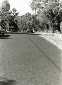
Photograph, Leaving Debbie Place, North Ringwood, now ready for metalling on 3 November 1978
... of the "Kubis" Estate, Ringwood North, including road works to Debbie... Road Ringwood North melbourne E551 N12 Part of a 51-photo ...E551 N12 Part of a 51-photo record of the development of the "Kubis" Estate, Ringwood North, including road works to Debbie Place, Kubis Drive, Werac Drive, Manuelo Drive, Iluka Place and Glenvale Road. From the Jack Lundy Clarke collection.51 -
 Eltham District Historical Society Inc
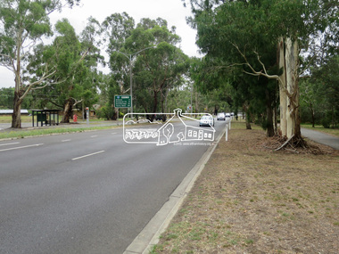
Photograph, Jim Connor, Main Road, Eltham, 14 Jan 2017
... Eltham Gateway, Looking north along Main Road near Eltham... melbourne Eltham Gateway, Looking north along Main Road near Eltham ...Eltham Gateway, Looking north along Main Road near Eltham Lower ParkTomorrow's history documented todayeltham, jim connor collection, main road, eltham gateway -
 Tarnagulla History Archive
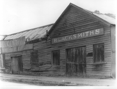
Photograph of blacksmith's shop, Tarnagulla, Blacksmith's shop, Tarnagulla, c. 1960
... the blacksmiths premises on the north end of Commercial Road, Tarnagulla... weatherboard building at the north end of Commercial Road, Tarnagulla...-down weatherboard building at the north end of Commercial Road ...Murray Comrie Collection. This photograph shows the blacksmiths premises on the north end of Commercial Road, Tarnagulla. Information collated by Murray Comrie: This building was demolished in the 1970s. The first use of the site was as the George Hotel licensed to an A.B. Clay in 1858, then Waller and Robinson. Charles Waller operated his Excelsior Line of coaches from the George Hotel stables. John Ousley took over the stables for use as a blacksmith's shop. He sold out to Stafford & Sons in 1908. Staffords found the existing premises at the George Hotel too small and built this building. Frank McNamee later took over the premises and operated it for many years. This photograph is a reasonable copy created from an older original. Copy probably made by Murray Comrie in the 1970s. Monochrome photograph depicting a large run-down weatherboard building at the north end of Commercial Road, Tarnagulla. Written in a sign on right side of building: 'Blacksmiths'. Same as image THA-2019.0053tarnagulla, commerce, industry, blacksmithing, smithing, coachbuilding, businesses, stafford & sons, norwood, mcnamee, buildings, hotels, horses, stables, commercial road, main street -
 Whitehorse Historical Society Inc.
Photograph, Blossom Street, Mitcham, 4/01/2001 12:00:00 AM
... Three streets West of Heatherdale Road - running north... of Heatherdale Road - running north and south - one street east ...Three streets West of Heatherdale Road - running north and south - one street east of Purches Street.blossom street, mitcham. -
 Whitehorse Historical Society Inc.
Photograph, Blackburn Post Office, 6/01/2001 12:00:00 AM
... North East from Railway Road, Blackburn....Whitehorse Historical Society Inc. 2-10 Deep Creek Road ...Black and white photograph of Blackburn Post Office looking North East from Railway Road, Blackburn.blackburn post office. -
 Tarnagulla History Archive
Photograph of Fiore Lodge, Tarnagulla, Fiore Lodge, Tarnagulla, Late 1960s
... Lodge', located at the north end of Commercial Road, Tarnagulla..... Was at one time the residence of Ena Bock. tarnagulla commercial road ...Murray Comrie Collection. Was at one time the residence of Ena Bock.Monochrome photograph depicting a house with name 'Fiore Lodge', located at the north end of Commercial Road, Tarnagulla.tarnagulla, commercial road, commerce, shopfronts, shops, businesses, bakery, food, stockfeed, grains, agriculture, doctor, surgeon, medical, medicine -
 Whitehorse Historical Society Inc.
Photograph, Blackburn Road
... Road looking north towards railway crossing... of beginning of Blackburn Road looking north towards railway crossing ...Black/white - Very early photo of beginning of Blackburn Road looking north towards railway crossingblackburn road, armstrong, ian -
 Melbourne Tram Museum
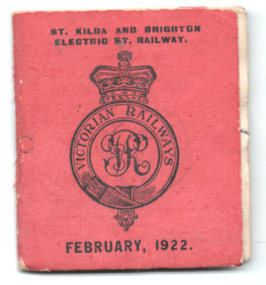
Ephemera - Tram Monthly ticket book, Victorian Railways (VR), Feb. 1922
... ) for Feb. 1922 from North Road to St Kilda. The traveller also had...) for Feb. 1922 from North Road to St Kilda. The traveller also had ...Victorian Railways Rail & Tram Monthly Periodical book of tickets with conditions of travel on the inside covers. See reference page 124/125 and Figure 6-35. Book of 60 tickets (No. 49) for Feb. 1922 from North Road to St Kilda. The traveller also had to hold a monthly rail ticket for St Kilda station to Melbourne. The conductor would tear out each ticket and hand half one portion back to the traveller. Has been stamped "cancelled". See item 1688 for a single sheet example.Demonstrates a Victorian Railways Rail and Tram monthly ticket for a specific section or trip on the St Kilda Brighton tramway. May have been used as a training sample. Shows the complexity of the monthly ticket system and the cost of printing such books for each month and each section of the tramway.Printed book, 30 pages + red cover, centre stapled with perforated tickets or coupons.tickets, vr, vr trams, victorian railways, st kilda brighton tramway, monthy -
 The Ed Muirhead Physics Museum
Photograph, “J” Apparatus in Laboratory
... Specialists, 337 Balwyn Road, North Balwyn 3104. Tel: 816 3691”... Balwyn Road, North Balwyn 3104. Tel: 816 3691” Black and white ...Black and white photograph of “J” Apparatus laboratory (refer to Reg No. 33 and Reg No. 34). Laminated photograph is mounted on wood and secured with masking tape. Metal hook on back for hanging. Frame is painted black.Stamped on back: “Artfilm Laminating Block Mounting Specialists, 337 Balwyn Road, North Balwyn 3104. Tel: 816 3691” -
Glenelg Shire Council Cultural Collection
Postcard - Postcard - Lighthouse and harbour Portland Victoria, n.d
... children walking on an unsealed road north of Whaler's Bluff.... road north of Whaler's Bluff. Postcard Postcard - Lighthouse ...Postcard, Lighthouse & Harbour, Portland, Victoria, from the "Rose" series ----colourview No 503, showing adult & three children walking on an unsealed road north of Whaler's Bluff. -
 Whitehorse Historical Society Inc.
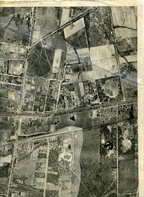
Map, Photo-map Ringwood A4A, 1945
... (North to south). Names of main roads inscribed.... Road (North to south). Aerial photo covering approximately from ...Aerial photo covering approximately from Box Hill to Mitcham (West to East) and Springfield Road to Hawthorn Road (North to south).Aerial photo covering approximately from Box Hill to Mitcham (West to East) and Springfield Road to Hawthorn Road (North to south). Names of main roads inscribed.Aerial photo covering approximately from Box Hill to Mitcham (West to East) and Springfield Road to Hawthorn Road (North to south).aerial photographs, box hill, blackburn, nunawading, forest hill, mitcham