Showing 37437 items
matching orbost-shire-council
-
 Eltham District Historical Society Inc
Book, Conservation Management Plan - Eltham Justice Precinct (January 2006) prepared for Nillumbik Shire
Guidance on the heritage issues in the management of the court house and former police buildings of the early justice precinct at Eltham.68 p, 30 cm. Also draft copy - Conservation Management Plan (draft) for Justice Precinct Eltham (July 2005) prepared for Nillumbik Shire 2006 This copy is the property of the Eltham District Historical Society Inc.eltham justice precinct, justice precinct eltham -
 Learmonth and District Historical Society Inc.
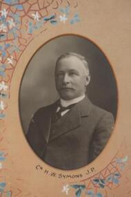
Photo - Symons, Richards & Co. Photos Ballaarat, H.W.Symons.J.P, "Circa 1912"
Councilor H.W.Symons, J.P. was elected to council in1893 until 1914.He was appointed Shire President in 1898-99,1904-05 and 1910-11.Original Historic Photo for 1911-12.Sepia photo, oval in shape, of Councilor H.W. Symons.J.P.It is set in a pinkish/tan mount with decorative features of flowers in tan,blue and white.The photo is on the right side of middle row of collection of photos of all councilors fo 1911-12.Presented to the Ballarat Shire Council,J.Dickie Esq.J.P.President 1911-12.ballarat shire council, 1893 1914, symons h w j p -
 Eltham District Historical Society Inc
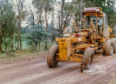
Photograph, Road Grading, Eltham Shire Council, c. Oct 1987, 1987
Date based on other similar display panels visible in images of the Shire of Eltham display at the Eltham Community Festival, 7 November 1987.Colour photograph mounted on green cardboard paneldisplay panel, eltham festival, infrastructure, shire of eltham, equipment, road maintenance, graders -
 Eltham District Historical Society Inc
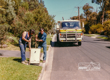
Photograph, Stormwater Maintenance, Eltham Shire Council, c. Oct 1987, 1987
Date based on other similar display panels visible in images of the Shire of Eltham display at the Eltham Community Festival, 7 November 1987.Colour photographdisplay panel, eltham festival, infrastructure, shire of eltham, maintenance works, eltham shire council -
 Eltham District Historical Society Inc
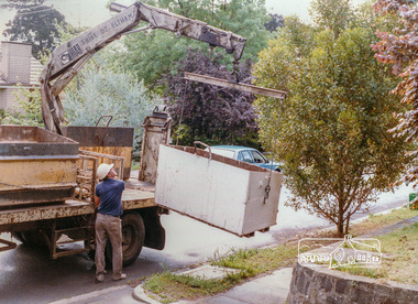
Photograph, Hard Waste Collection, Eltham Shire Council, c. Oct 1987, 1987
Date based on other similar display panels visible in images of the Shire of Eltham display at the Eltham Community Festival, 7 November 1987.Colour photographdisplay panel, eltham festival, infrastructure, shire of eltham, garbage collection, hard waste collection -
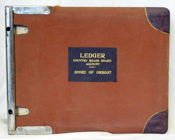 Orbost & District Historical Society
ledger, 1950's -1960's
This ledger was used bt the Shire of Orbost local government to record Country Roads Board accounts 1950's and 1960's. The item was donated to Orbost & District Historical society from P.R.O.V. as a Place of Deposit (POD) item for safe keeping by a local history group or museum. The shire covered an area of 9,347 square kilometres and existed from 1892 until 1994 when it became part of the East Gippsland Shire Council. Orbost was at first included in the Bairnsdale Shire from 1882 and was later part of the Tambo Shire. Because of travelling distances the Croajingalong Shire was created in 1892 (name changed to Orbost Shire 17.2.1893 with James Cameron as the first Shire President. In 1994 it amalgamated to become part of East Gippsland Shire Council. The Country Roads Board was the government authority for the construction and maintenance of main roads in Victoria between 1913 and 1983. It was succeeded by the Road Construction authority on 1 July 1983 and later merged with the Road Traffic Authority on July 1 1989 to form the Roads Corporation. James Cameron, an Orbost farming pioneer and Member of the Legislative Assembly, fathered the Country Roads Board. This ledger is a hand-written record of accounts for the Orbost Shire local council. It pre-dates computer records. The Orbost Shire Council no longer exists having been absorbed into the East Gippsland Shire Council.A heavy brown coloured ledger with covered wooden covers. it has steel metal binding. Inside are strips of paper marking pages. It contains blue ink hand-written records of monies in/out (?) to Shire of Orbost Council. On the front cover inside a black rectangle in gold print is " LEDGER COUNTRY ROADS BOARD ACCOUNT ORBOST". It is an "Emu Binder".ledger orbost-shire accounts country-roads-board -
 Greensborough Historical Society
Book, Nillumbik Shire Council, 1997 Community Guide Nillumbik, 1997_
Guide to services provided by Nillumbik Shire Council. Nillumbik Shire is located 25 kilometres north-east of Melbourne and the southern boundary is the Yarra River. The south of Nillumbik is predominantly urban, with commercial centres at Eltham and Diamond Creek. The north of the municipality includes significant natural features like Kinglake National Park and Sugarloaf ReservoirAnnual guide to services in Nillumbik. 64 pages. Cover is pale yellow with colour drawings. nillumbik shire council, handbooks -
 Greensborough Historical Society
Book, Nillumbik Shire Council, 1998 Community Guide Nillumbik, 1998_
Guide to services provided by Nillumbik Shire Council. Nillumbik Shire is located 25 kilometres north-east of Melbourne and the southern boundary is the Yarra River. The south of Nillumbik is predominantly urban, with commercial centres at Eltham and Diamond Creek. The north of the municipality includes significant natural features like Kinglake National Park and Sugarloaf ReservoirAnnual guide to services in Nillumbik 72 pages. Cover has white background and some 3-D artwork.nillumbik shire council, handbooks -
 Greensborough Historical Society
Book, Nillumbik Shire Council, 1999 Community Guide Nillumbik, 1999_
Guide to services provided by Nillumbik Shire Council. Nillumbik Shire is located 25 kilometres north-east of Melbourne and the southern boundary is the Yarra River. The south of Nillumbik is predominantly urban, with commercial centres at Eltham and Diamond Creek. The north of the municipality includes significant natural features like Kinglake National Park and Sugarloaf ReservoirAnnual guide to services in Nillumbik76 pages, illus. Cover has photographs of local people and title in white on orange background.nillumbik shire council, handbooks -
 Greensborough Historical Society
Book, Nillumbik Shire Council, Nillumbik Community Guide 2000/2001, 2000-2001
Guide to services provided by Nillumbik Shire Council. Nillumbik Shire is located 25 kilometres north-east of Melbourne and the southern boundary is the Yarra River. The south of Nillumbik is predominantly urban, with commercial centres at Eltham and Diamond Creek. The north of the municipality includes significant natural features like Kinglake National Park and Sugarloaf ReservoirAnnual guide to services in Nillumbik76 pages, black and white illustrations. Cover has a collage of local children with title in white on mid-blue background.nillumbik shire council, handbooks -
 Lakes Entrance Historical Society
Book, Tambo Shire Society Members, Tambo Shire Historical Society, 1999
Newspaper clippings recording activities of Tambo Shire Historical Society until the name change to Lakes Entrance regional Historical Society at 4 Marine Parade Lakes Entrance Victoriahistorical society, community services -
 Beechworth Honey Archive
Publication, State of the industry 2012: essential information: facts and figures. (Australian Food and Grocery Council). Canberra, 2012, 2012
70 pages, illustrated. -
 Beechworth Honey Archive
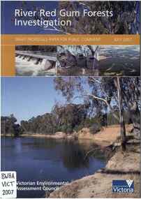
Publication, River Red Gum forests investigation: draft proposal paper for public comment (Victorian Environmental Assessment Council), East Melbourne, 2007, 2007
-
 Federation University Historical Collection
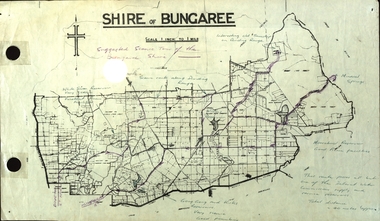
Plan, Shire of Bungaree
The former Shire of Bungaree is now part of Moorabool Shire.Plan of the Shire of Bungaree. Scale is 1 inch to 1 mile with the total distance approximately 40 miles. Includes Gong Gong Reservoir, Kirks Reservoir, White Swan Reservoir, Wilson's Reservois and Moorabool Reservoir. Purple line in purple pencil indictaes suggested scenic tour of the Bungaree Shirebungaree, water supply, barkstead, humffray street, ballarat, doveton (north) stret, ballarat, ballarat water commission, great dividing range, wombat state forest, mineral water springs, gong gon reservoir, kirks reservoir -
 Learmonth and District Historical Society Inc.
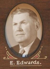
Photo - Edwards, Thornton Richards & Co Ballarat, Edwards. E. Councilor, 1954, 1954 (exact)
Councilor E.Edwards was elected to council in1951 until 1970.He served two terms as Shire President 1957-58 and 1965-66.This photo, which is part of a composite collection of photos, was taken to commemorate the 1954 visit of her Majesty Queen Elizabeth 11,and was presented by the Shire President,G.A.Fraser, to mark the occaision.Section of The Original Historical Photo of Councilors for the year 1954.Sepia/brown photo of Councilor E.Edwards. Situated second from left,middle row of composite photos of Councilors for the year 1954.PRESENTED TO BALLARAT SHIRE COUNCIL BY SHIRE PRESIDENT TO COMMEMORATE THE VISIT OF HER MOST GRACIOUS MAJESTY QUEEN ELIZABETH 11. 1954..ballarat shire council, e edwards, visit of her majesty queen elizabeth 11 1954 -
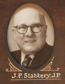 Learmonth and District Historical Society Inc.
Photo - Slattery, Thornton Richards & Co Ballarat, Slattery. J.P. (J.P.) Councilor 1954, 1954 (exact)
Councilor J.P.Slattery (J.P.), was elected to council in 1943 until 1955.He served one term as Shire President, 1949 - 50.This photo,which is part of a collection of photos, was taken to commemorate the 1954 visit of Her Majesty Queen Elizabeth 11, and was presented by the Shire President, G.A.Fraser, to mark the occaision.Section of the Original Historical Photo of Councilors for the financial year 1954.Sepia/brown photo of Councilor J.P.Slattery,(J.P.).Situated second from right, middle row, of composite photo of Councilors for the year 1954.PRESENTED TO BALLARAT SHIRE COUNCIL BY SHIRE PRESIDENT TO COMMEMORATE THE VISIT OF HER MOST GRACIOUS MAJESTY QUEEN ELIZABETH 11 1954ballarat shire council, visit of her majesty queen elizabeth 11 1954, j p slattery jp -
Greensborough Historical Society
Report, Banyule City Council, Saxam report 2014, Banyule Council, 10/06/2014
Reports by Banyule Council officers and minutes of Council meetings relating to the Heritage importance of Saxam Homestead in Greensborough.16 pages in 3 documents.saxam -
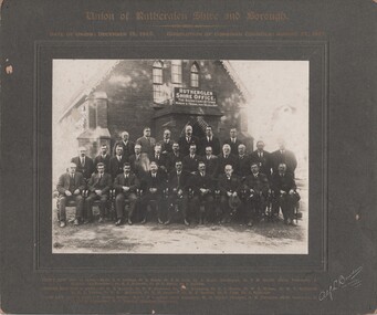 Rutherglen Historical Society
Photograph - Image, Alf L. Bowden, The Studio, Union of Rutherglen Shire and Borough, 1921
The building is the old Shire Hall (formerly a Church) in High Street. Roy Ready Senior bought the land and building and built his house with it as a part.Black and white photograph, mounted on cardboard, of a number of men in front of a building labelled Rutherglen Shire Office. Printed at top of mount: "Union of Rutherglen Shire and Borough | Date of Union: December 15, 1920. dissolution of Combined Councils: August 25, 1921." Complete list of individual names printed at bottom of mount. At bottom right of mount: "Alf L Bowden, The Studio, Corowa, N.S.W." Note from donor pasted on back of mount.rutherglen shire, rutherglen borough, shire buildings, rutherglen shire councillors, roy ready -
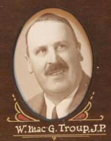 Learmonth and District Historical Society Inc.
Photo - Mac'G Troup, Thornton Richards & Co Ballarat, William Mac'Gregor Troup.W. (J.P.) Councilor 1954, 1954 (exact)
Councilor William Mac'Gregor Troup was elected as a member of council in1953 until 1970.He served one term as Shire President in1960-61.This photo which forms part of a collection of photos was taken to commemorate the 1954 visit of Her Majesty Queen Elizabeth 11,and was presented by the Shire President G.A.Fraser to mark the occaision.Section of the Original Historic Photo of Councilors for the financial year 1954,to commemorate the visit of Queen Eliabeth 11.Sepia/brown photo of Councilor William Mac'Gregor Troup,(J.P.),situated second from right, bottom row, of composite photo of Councilors for the year 1954.PRESENTED TO BALLARAT SHIRE COUNCIL BY SHIRE PRESIDENT TO COMMEMORATE THE VISIT OF HER MOST GRACIOUS MAJESTY QUEEN ELIZABETH 11,1954.shire of ballarat 1954, visit of her majesty queen elizabeth 11, william macgregor troup jp -
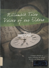 Eltham District Historical Society Inc
Book, Nillumbik Shire Council, Nillumbik tales : voices of our elders, 2014
On 4th October 2014 Nillumbik Shire Council launched a publication titled ‘Nillumbik Tales - Voices of our Elders’, which is a collection of colourful and personal snapshots of our local community. The unique Nillumbik based stories have been written by a variety of authors, including some who are members of our Society. In collating and publishing this historically important collection Nillumbik Shire Council has documented many aspects of our area and of the people who contributed to our community. The original print run of ‘Nillumbik Tales’ was sold out and there has been a reprint.Catalogue labels on spine and cover from Yarra Plenty Regional Library. Electronic ID label (RFID tag) inside rear covergardens, school, family, characters, organisations, place, local history, kangaroo ground, kinglake, nillumbik, bend of islands, eltham, cave, reminscences -
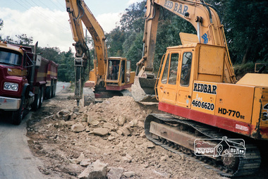 Eltham District Historical Society Inc
Photograph, Council Road Construction works, Shire of Eltham, c. Oct 1987, 1987
Date based on other images from negative roll of similar display panels visible in images of the Shire of Eltham display at the Eltham Community Festival, 7 November 1987.Roll of 35mm colour negative film, 3 of 7 stripsKodak GA 100 5095shire of eltham, infrastructure, road construction, roadworks -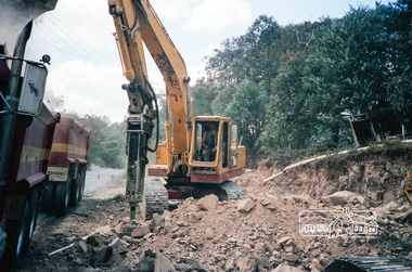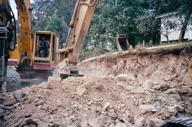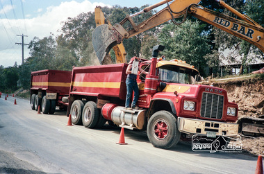
University of Melbourne, Burnley Campus Archives
Album - Colour slides, Orbost Trip, 1969-1985
Box of slides labelled "Orbost Trip Oct. 69" with some additional slides dated 1980, 1982, 1985orbost, excursions, 1969 -
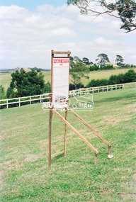 Eltham District Historical Society Inc
Negative - Photograph, Harry Gilham, Nillumbik Shire Council Notice of an Application for Planning Permit, 385 Eltham-Yarra Glen Road, Kangaroo Ground, 2002
Planning application 293/2002/06P by Harry Gilham for the Moor-rul viewing platform, road entrance revisions, earthworks and coach parking bays at the Shire of Eltham Memorial ParkRoll of 35mm colour negative film, 1 strip, 2 framesKodak Gold 200-6eltham-yarra glen road, kangaroo ground, moor-rul viewing platform, shire of eltham memorial park, harry gilham, nillumbik shire council, planning permit -
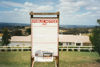 Eltham District Historical Society Inc
Photograph, Harry Gilham, Nillumbik Shire Council Notice of an Application for Planning Permit, 385 Eltham-Yarra Glen Road, Kangaroo Ground, 2002
Planning application 293/2002/06P by Harry Gilham for the Moor-rul viewing platform, road entrance revisions, earthworks and coach parking bays at the Shire of Eltham Memorial ParkColur photo print (4)eltham-yarra glen road, kangaroo ground, moor-rul viewing platform, shire of eltham memorial park, harry gilham, nillumbik shire council, planning permit -
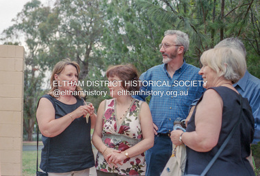 Eltham District Historical Society Inc
Photograph, Local government election celebrations outside Nillumbik Shire Council offices, 34 Civic Drive, Greensborough, Nov. 2004
Newly elected Nillumbik Shire Councillors Helen Coleman, Bronnie Hattam and Michael Young celebrate with re-elected Councillor Greg Johnson following the November 2004 Local Government elections.Roll of 35mm colour negative film, 7 stripsKodak GC400-8bronnie hattam, greg johnson, helen coleman, jim connor, local government elections, marg johnson, nillumbik shire council -
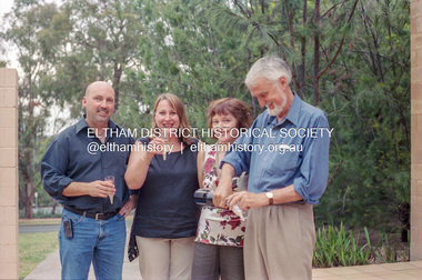 Eltham District Historical Society Inc
Photograph, Local government election celebrations outside Nillumbik Shire Council offices, 34 Civic Drive, Greensborough, Nov. 2004
Newly elected Nillumbik Shire Councillors Helen Coleman, Bronnie Hattam and Michael Young celebrate with re-elected Councillor Greg Johnson following the November 2004 Local Government elections.Roll of 35mm colour negative film, 7 stripsKodak GC400-8bronnie hattam, greg johnson, helen coleman, local government elections, marg johnson, nillumbik shire council, michael young -
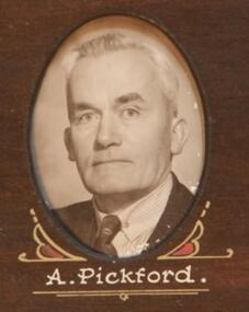 Learmonth and District Historical Society Inc.
Photo - Pickford.A, Thornton Richards & Co Ballarat, Pickford. Arthur, Councilor 1954, 1954 (exact)
Councilor Arthur Pickford was elected as a member of council in 1941 until 1951 and again in 1953 until 1958. He served one term as Shire President in 1947-48.This photo which is part of a collection of photos was taken to commemorate the 1954 visit of Her Majesty Queen Elizabeth 11,and was presented by the Shire President G.A Fraser, to mark the occaision.Original historic photo of all councilors for 1954,taken to commemorate the visit of Queen Elizabeth 11. Sepia/brown photo of Councilor Arthur Pickford,situated at bottom right hand corner of composite photo of Councilors for the year 1954.PRESENTED TO BALLARAT SHIRE COUNCIL BY SHIRE PRESIDENT TO COMMEMORATE THE VISIT OF HER MOST GRACIOUS MAJESTY QUEEN ELIZABETH 11, 1954arthur pickford, ballarat shire council 1954, queen elizabeth 11